
Journal of Geo-information Science >
Reasons and Risk Assessment of Housing Damage in the National Mountain Torrent Disaster Prevention County
Received date: 2017-07-10
Request revised date: 2017-10-28
Online published: 2017-12-25
Copyright
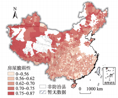
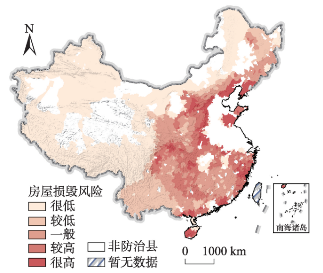
The economic losses caused by torrential disaster in China are increasing. Housing damage plays an important role in economic losses and casualties. Based on the data provided by the survey and evaluation of torrent disaster, we analyzed the temporal and spatial distribution features of house exposure, constructed the damage risk assessment model of torrent disaster, analyzed the causes of housing damage risk and explored the reasons. The results showed that: (1) The houses in China rural area are mainly one-layer building, and distribution of one-layer dominated county is roughly the same with the boundary of the third terrain ladder of China; brick-concrete structure is the main housing structure in mountainous rural areas, followed with brick-wood structure, steel-concrete structure and other structures are the least. (2) Overall, the housing vulnerability is high in the northwest and low in the southeast, while the housing damage risk is high in the east and low in the west. The areas with extremely high damage risk are concentrated in the Liaodong Peninsula, Shandong Peninsula, Hainan Island and the Southeastern coastal areas and Yanshan-Taihang Mountains. The areas with high damage risk are banded or agglomerated, which are mainly distributed in the Taihang Mountains and middle-lower reaches of Yangtze River. (3) The high housing damage risk in Shandong, Shanxi and Hebei province are more relied on housing structure types. The houses with high damage risk which are mainly due to torrent strength are located within three stripes: Yanshan-Taihang Mountains Belt, Zhejiang-Fujian Coastal Hilly Belt, Guangdong-Guangxi Coastal Belt.
WANG Nan , CHENG Weiming , ZHANG Yichi , LIU Dongcheng . Reasons and Risk Assessment of Housing Damage in the National Mountain Torrent Disaster Prevention County[J]. Journal of Geo-information Science, 2017 , 19(12) : 1575 -1583 . DOI: 10.3724/SP.J.1047.2017.01575
Tab. 1 Definitions of the four types of housing structure in the Fifth National Census表1 房屋结构类型的定义 |
| 结构类型 | 定义 |
|---|---|
| 钢混结构 | 指承重的主要构件是用钢筋混凝土建造的。包括薄壳结构、大模板现浇结构及使用滑模、升板等建造的钢筋混凝土结构的建筑物 |
| 砖混结构 | 指承重的主要构件是用钢筋混凝土和砖木建造的。如一幢房屋的梁是用钢筋混凝土制成,以砖墙为承重墙,或者梁是用木材建造,柱是用钢筋混凝土建造 |
| 砖木结构 | 指承重的主要构件是用砖、木材建造的。如一幢房屋是木制房架、砖墙、木柱建造 |
| 其他结构 | 指凡不属于上述结构的房屋都归此类。如竹结构、砖拱结构、窑洞 |
Tab. 3 Building damage coefficient of torrent disaster表3 全国山洪灾害防治区房屋易损系数 |
| 结构类型 | 建筑类型 | |||
|---|---|---|---|---|
| 一层住宅 | 二层住宅 | 三层住宅 | 其他住宅形式 | |
| 其它结构 | 0.9 | 0.8 | 0.7 | 0.6 |
| 砖木结构 | 0.8 | 0.7 | 0.6 | 0.5 |
| 砖混结构 | 0.7 | 0.6 | 0.5 | 0.4 |
| 钢混结构 | 0.6 | 0.5 | 0.4 | 0.3 |
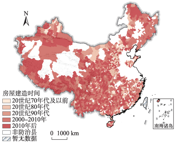
Fig. 2 Distribution of housing construction age图2 全国山洪灾害防治县房屋主要建造年代分布 |
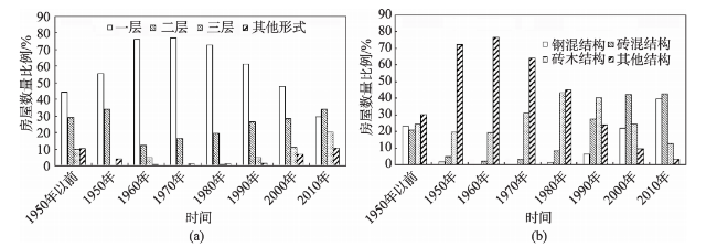
Fig. 3 Inter-decadal changes in the proportion of housing图3 全国山洪灾害防治县房屋比例年代际变化 |
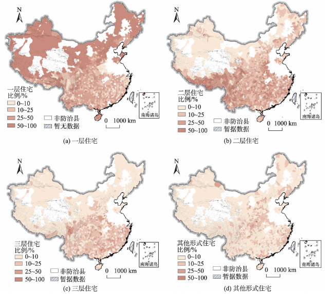
Fig. 4 Distribution of housing building types图4 全国山洪灾害防治县房屋建筑类型空间分布 |
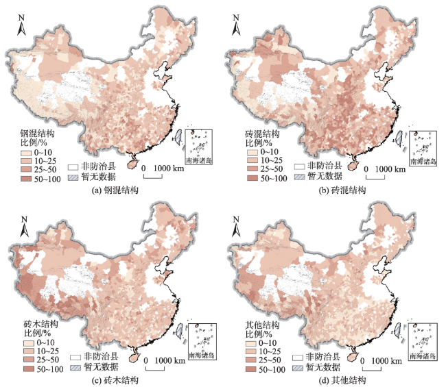
Fig. 5 Distribution of housing structure types图5 中国县级尺度山洪灾害防治区房屋结构类型空间分布 |
Fig. 6 Distribution of housing vulnerability图6 全国山洪灾害防治县房屋脆弱性分布 |
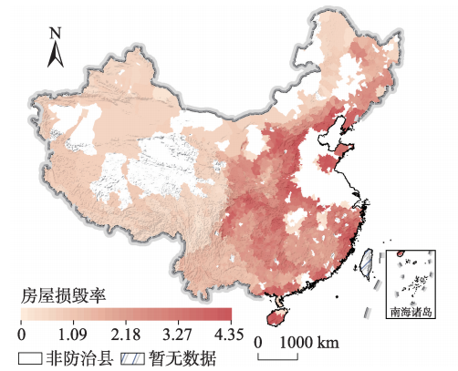
Fig. 7 Distribution of housing damage ratios图7 全国山洪灾害防治县房屋损毁率分布 |
Fig. 8 Distribution of housing damage risk图8 全国山洪灾害防治县房屋损毁风险分布 |
The authors have declared that no competing interests exist.
| [1] |
[
|
| [2] |
[
|
| [3] |
[
|
| [4] |
[
|
| [5] |
[
|
| [6] |
[
|
| [7] |
|
| [8] |
|
| [9] |
[
|
| [10] |
|
| [11] |
[
|
| [12] |
|
| [13] |
|
| [14] |
[
|
| [15] |
|
| [16] |
[
|
| [17] |
[
|
| [18] |
[
|
| [19] |
[
|
| [20] |
[
|
| [21] |
[
|
| [22] |
[
|
| [23] |
[
|
| [24] |
[
|
| [25] |
[
|
/
| 〈 |
|
〉 |