Geologic Time Scale Ontology and Its Applications in Semantic Retrieval

  • HOU Zhiwei , 1, 2 ,
  • ZHU Yunqiang 1, 4, 5 ,
  • GAO Ying 3 ,
  • SONG Jia , 1, * ,
  • QIN Chengzhi 1, 2, 4
Expand
  • 1. State Key Laboratory of Resources and Environmental Information System, Institute of Geographic Sciences and Natural Resources Research, Chinese Academy of Sciences, Beijing 100101, China
  • 2. University of Chinese Academy of Sciences, Beijing 100049, China
  • 3. Honours College of Capital Normal University, Beijing 100048, China
  • 4. Jiangsu Center for Collaborative Innovation in Geographical Information Resource Development and Application, Nanjing 210023, China
  • 5. Baiyangdian Lake Ecological Protection and Sustainable Development of Jing-jin-ji Collaborative Innovation Center, Baoding 071002, China
*Corresponding author: SONG Jia, E-mail:

Received date: 2017-07-17

  Request revised date: 2017-10-18

  Online published: 2018-01-20

Supported by

Natural Science Foundation of China, No.41371381, 41631177;National Special Program on Basic Works for Science and Technology of China, No.2013FY110900;the Public and Basic Geological Project of Guizhou Province, China, No.[2014]23;GuiZhou Welfare and Basic Geological Research Program of China, No.201423, 2016269.

Copyright

《地球信息科学学报》编辑部 所有

Abstract

Different countries or organizations publish different versions or language editions of geologic time scales. Problems of ambiguity, such as synonymy or near-synonym and polysemy or other kinds of semantic heterogeneity arise in those geochronological concept systems, along with the lack of semantic linkage among different concepts and data, have hindered people from understanding and using those concepts accurately. Also, this caused insufficient results of integration and retrieval of geo-data for users’ requirements. The ontology of geologic time proved to be an effective solution to these problems. However, current studies focus on international geologic time scales, and their content and formalizations are not fully applicable in China. In this paper, we present a new Geologic Time Scale Ontology which mainly focuses on Chinese geochronological and stratigraphic concept systems. It describes the formalizations of attributes, especially the temporal features and relations of those concepts. It adopts a modular method to build this ontology. In addition, we propose a design of a pilot system to study the utility of this ontology as the basis of a geoscience knowledge graph in knowledge retrieval. Furthermore, we implemented an approach of semantic geo-data retrieval in the pilot system which uses a hybrid strategy of fulltext and ontology-based search. Applications of knowledge graph and geo-data retrieval based on the abilities such as temporal reasoning of Geologic Time Scale Ontology, proved that the proposed researches are effective in resolving semantic heterogeneity issues in geoscience knowledge and data. They can not only facilitate discovery of geoscience knowledge but also achieve the function of semantic data retrieval more intelligently, comprehensively and accurately for the discovery of specified and relevant data.

Cite this article

HOU Zhiwei , ZHU Yunqiang , GAO Ying , SONG Jia , QIN Chengzhi . Geologic Time Scale Ontology and Its Applications in Semantic Retrieval[J]. Journal of Geo-information Science, 2018 , 20(1) : 17 -27 . DOI: 10.12082/dqxxkx.2018.170328

1 引言

地质年代是表明地质事件发生时代及其相互关系的时间系统,是地球科学研究中最基本的要素之一[1]。地质年代与时空上分布的地质事件、地层等都存在密切关系,对地学各领域、全球变化研究及地质信息化建设等都具有十分重要的理论和实际意义[2,3,4,5]。然而,不同国家或组织所提出的地质年代等概念在定义、更新、应用等过程中都存在一词多义、异词同义等语义异质性问题[6]。概念间复杂的、显性或隐性存在的时空、语义关联关系也缺少形式化表达等。这些问题严重阻碍了地学知识与数据的准确应用和相互关联与智能推荐、高效检索,是地学数据共享、地学信息化建设必须解决的重要问题之一[7,8,9]
本体是共享概念模型明确的形式化规范说 明[10],用于确定领域内共享的词汇,并明确定义这些词汇和词汇间的关联关系[11]。本体还具备语义推理能力,能根据规则自动建立词汇间的关联。本体的这些特性使其被广泛应用于地质年代相关领域知识、时空数据的形式化表达和语义关联应用,以满足用户对分布式多源异构、多语言知识和数据服务的查询检索、共享与互操作需求[12,13,14]。知识图谱泛指各种大规模的、结构化的语义知识库,是一种揭示实体之间关系的语义网络,在智能搜索、个性化推荐等领域有重要的应用价值[15]。本体对公理、规则和约束条件的支持能力被用于规范知识图谱中的实体及其联系[16]。包含大量概念实体及各类关系的地质年代本体,可用于研究地质年代知识图谱的基本模式与应用。
国际上已对地质年代本体开展了较多的研究,代表性研究如表1所示。结合Ma等[12]及Cox等[17]的梳理可发现,这些本体在所表达的概念内容、时间关系和属性(起始和终止时间、地质年龄)表达方式方面都存在一定的共性。在内容方面,主要以多语言地质年代概念,全球标准层型剖面和点位(Global Standard Stratotype-Section and Points, GSSP)、地层等内容为主[14, 17-18]。而在概念时间属性表达方面,为同时表达年代值与误差、单位等内容,多数本体使用了面向对象的表达方式,即将时间属性表达为一个概念(或称实例)。如SWEET (Semantic Web for Earth and Environmental Terminology) 本体中的“251.0MYA”概念[19]及GTS本体中的“isc:BaseMiddleJurassicTime”[17]实例等。在地质年代时间关系表达方面,主要趋势是采用通用的时间拓扑模型。SWEET本体采用了时间区间代数[20],Perrin等[21]采用了OWL-Time本体,而Cox等[4,17]则采用实现了ISO 19108:2002时间拓扑模型和时间顺序参考系统模型 TORS (Temporal Ordinal Reference System Model)的THORS(Temporal Hierarchical Ordinal Reference System)本体,通过thors:nextEra等关系谓词表示年代概念间的时间拓扑关系。在本体应用方面,主要关注点在于建立地质年代与地层知识库,克服概念语义歧义,建立地质年代相关概念与数据间的关联,促进知识发现、数据集成与查询检索、共享[8, 12, 17-18, 22]
Tab. 1 Some representative ontologies of geologic time scale

表1 部分代表性地质年代本体

本体名称 文献 主要内容 年代关系表达 概念时间值表达 应用
SWEET Raskin等[19] 国际地质年代 时间区间代数 “{百万年值}[8]MYA”对象及其数值属性 建立概念关联,促进地学数据的发现与使用
Geological Time & Dating Ontology Perrin 等[18] 国际地质年代、地层、地质事件 OWL-Time 本体 GeochronologicBoundary 与GeochronologicInstant对象及其数值属性 地质年代及地层层序的形式化描述与关联、定年
GTS ontology Ma等[14] 国际地质年代、GSSP、多语言注释 gts:lowerThan等关系谓词 gts:upperBoundaryTime、gts:lowerBoundaryTime属性及其值 在线地质图地质年代信息标注、可视化
GTS ontology (isc{版本年}) Cox等[17] 多版本国际地质年代与地层、GSSP、多语言注释 THORS本体 “{isc:Base年代}Time”对象及其数值属性 地学专家的地质年代参考系统,地质年代调查、发展参考资料
国内目前对地质年代本体的研究较少。董少春等[6]研究了地质时间本体的构建,探讨了地质时间本体在异构数据语义检索中的应用;吴立新等[23]研究了沉积地层本体及其在数据集成与地层关系判断中的应用。二者在本体内容、多语言概念、时间关系的表达上都不完善,难以解决语义异质性问题和实现时间语义推理、地质年代与地层等的关联。中国古生物学与地层学数据库[5]、基于地层时空拓扑关系的地质图数据自动检查系统[24]等信息系统,尚不具备语义查询、推理等功能,无法充分发挥地质年代和地层信息的作用。综上可见,国际上以国际年代地层表为主要依据的地质年代本体研究目前已取得不少成果。但中国地质年代在概念定义和命名、时间段划分等方面与国际地质年代划分不完全一致。如《中国地层表》[25]中的震旦纪在《国际年代地层表》[26]中称为埃迪卡拉纪,“泥河湾期”被划分为Calabrian(“卡拉布里雅期”)与Gelasian(“杰拉期”或“格拉斯期”)。而国内相关研究较少,不能解决中国地质年代本身及其与国际地质年代概念之间的语义异构、地质年代与地层等概念的语义关联缺失等问题。为此,通过分析地质年代概念及其特征,本文构建了以中国地质年代和地层划分等为主要内容的地质年代本体,对概念和时间信息的语义表达、本体构建方法等进行了设计。最后,以应用案例形式展示了该本体在地质年代知识查询和地学数据语义检索中的应用。

2 地质年代概念及其特征

2.1 地质年代与年代地层表

地质年代分为相对年代和绝对年龄(同位素年龄)。相对地质年代根据生物演化及岩石、地质构造等特征,把整个地质历史划分为一系列不同级别的历史阶段,即地质年代单位,借以展示岩石、地质事件等在时间上的顺序和包含关系。同位素年龄是指利用放射性元素的蜕变规律来测定的地质事件发生时刻距今(公元1950年)的单位时间值[22,27-28]。在表述地质年龄时,必须同时包含样品和测年方法等内容。因为对同一样品,采用不同的元素和方法测定的年龄及其误差是存在差异的。地质年代表(年代地层表)是地质年代的主要内容载体和表现形式。不同国家或组织的不同版本的地层表在年代单位命名和时间划分方面不尽相同。例如,2014版《中国地层表》[25]对部分界线的划分方案做了调整,同时对一些阶进行了重命名[29]

2.2 地质年代时间属性及其特征

根据侯志伟等[30]的论述,时间实体可分为时间点与时间段两种类型,并具有时间坐标系、时间位置与距离、时间关系、时间方向等基本属性。这些时间属性对于地质年代时间同样适用。例如,万晓樵等[1]指出,地质年代时间包含3个基本问题:① 地质事件是何时发生或结束的?② 各事件是否同时发生?③ 事件的持续时间和发生的速率如何?问题①的实质是确定时间位置,问题②的实质是确定事件间的时间拓扑关系。问题③与时间距离相关,涉及时间的量测。时间的量测首先需要确定时间坐标系,即时间起算点、尺度基准(时间单位系统)和时间方向;然后确定时间点的坐标值;最后进行持续时间及发生速率的计算。在时间特征方面,地质年代时间也符合侯志伟等[30]总结的地学数据时间的多尺度性、相对性、不确定性等特征。如不同级别地质年代单位的划分体现了其多尺度性和相对性,地质年龄误差、地质年代划分及底界年龄的不一致等则体现了不确定性。

2.3 地质年代与其他领域概念关系

地质年代是地层划分和对比、古生物、构造地质、地球化学等研究的最基本要素,在科学研究及工程实践中都有重要应用[1, 6]。地层分为岩石地层、生物地层、事件地层、年代地层等不同的类型。其中,生物地层和事件地层研究的基础,在于确定古生物化石、地质事件的相对年代或绝对年龄。年代地层单位与地质年代单位一一对应,其他地层类型则存在穿时现象[31]。年代地层还是划分和对比地层的最重要手段之一,任何其他相关地质学科如沉积环境分析、古地理重建等都首先要建立在时间对比准确的地层体基础之上[5]。为了建立这样一套精确划分的地层(时间)框架,国际地层委员会推行GSSP来定义年代地层单位[32]。地质年代信息也是地质图编绘、地质数据库建设中的主要内容之一。地质年代代码是地质图数据库中最重要的代码,在计算机生成图件时,它决定着地质体的着色及地质符号的生成[3]

3 本体结构设计与语义表达

3.1 地质年代本体结构设计

为充分利用现有时间本体和地质年代研究成果,并解决中国与国际地质年代系统、地层学、古生物学等领域中与地质年代相关的语义异构和数据关联问题,为科学研究与工程应用提供丰富的知识服务,基于上述地质年代概念及特征的分析,设计了由基础层、核心层与应用层3个层次内容组成的地质年代本体,如图1所示。
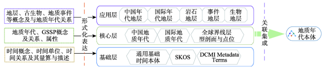
Fig. 1 Architecture of the Geologic Time Scale Ontology (GTSO)

图1 地质年代本体结构

基础层由领域无关的本体内容组成,主要内容包括侯志伟等[30]构建的定义了时间单位、时间坐标系、时间拓扑关系等基本时间概念、关系和公理的基础时间本体,用于知识共享和关联的通用数据模型SKOS(① https://www.w3.org/TR/skos-reference/#L895。)(Simple Knowledge Organization System)及网络资源描述元数据标准都柏林核心元数据集术语DCMI (Dublin Core Metadata Initiative) Metadata Terms(② http://dublincore.org/documents/dcmi-terms/#H3。)。基础层的目标是为地质年代本体提供“建立与人类社会接轨的时间单位和地质学时间坐标”[1,33],同时便于与其他类型的本体整合集成,扩展其应用范围。
核心层是地质年代本体的核心内容,是连接本体内部不同概念、实现概念相互关联的纽带和进行时态推理的基础。包含多语言的中国和国际地质年代单位概念及其属性和关系,还包括定义了精确地层时间框架,为地质年代提供了大量的点位地层和时空间信息的GSSP。
应用层由多个地层模块组成,以年代地层等地层信息及其与地质年代的关联关系等内容为主。另外,由于地层、地质过程和地质事件、古生物等将地质年代概念与其他地学学科概念相关联,是地质年代本体面向更广泛的地学科研、应用服务的关键内容,因此也是本体的重要组成部分。
地质年代本体中各主要模块基本内容、代表性实例和主要属性或关系的简要说明如表2所示。
Tab. 2 Definitions of ontology modules of geologic time scale

表2 地质年代本体模块定义

模块名称 主要内容 主要概念类 主要属性/关系 概念实例示例
基础时间本体 时间类型、单位、方向;时间属性与关系、时间信息描述规则 时间单位,时间坐标系,百万年等 timeAfter、intAfter、intMeets、intContains B.P.、逆时、百万年、145Ma
中国地质年代 中国地层表中确定的地质年代 宙、代、纪、世、期等 对应年代地层/对应国际地质年代 阳新世、周口店期
国际地质年代 国际地层委员会确定的地质年代 Eon、Era、Period、Epoch、Age等 对应年代地层、对应中国地质年代 Cambrian Period、Calabrian Age
全球界线层型剖面与点位 国际地层委员会确定的作为两个年代地层单位之间界线的定义和识别标准的专有标志点 按国际年代地层单位分类 地质年龄、经度、纬度、地理位置、综合图链接 Tortonian、Messinian
中国年代地层 在特定地质时间间隔内形成的岩石体。其顶底界线都是以等时面为界的 宇、界、系、统、阶等 标准RGB颜色、地质年龄、符号、岩性特征 第四系、更新统、周口店阶
国际年代地层 国际地层委员会确定的年代地层划分 Eonothem、Erathem、Series、System、Stage等 标准RGB颜色、地质年龄、符号、岩性特征 Guadalupian、Calabrian
中国岩石地层 根据地壳中岩石的特征和相互关系组织成的地层单位 群、组、段、层等 特点、正层型、分布 泰山岩群、上湖组、绒布寺冰碛层
中国事件地层 利用能在地层中留下某种印记并可被识别的较大范围分布的等时地质事件划分的对比地层 事件层、事件带、事件面及沉积事件、气候事件等 事件发生年代、事件发生区域、事件标志物 加里东运动、三叶虫首现、南极冰盖重大扩张
中国生物地层 将岩层根据地层中所含化石的特性编制成的若干地层单元 富集带、谱系带等;脊索动物门等 标准化石、包含生物种类 Claraia aurita富集带、三叶虫

3.2 概念语义表达

本体的核心是领域内共享概念的形式化表达。将概念用一个词和一组结构化的属性组表示,是实现概念形式化表达的有效途径[34]。属性是关于类成员的一般事实的断言以及个体的具体事实的断言,一个属性是一个二元关系[35]。概念属性包括性质(Property)与关系(Relation)2类。因而,本体中概念C的语义定义可表达为:
∃(term, P, R)[∀ CtermRP ] (1)
式中:C表示概念;term指概念术语;P表示概念的性质;R表示概念的关系。
概念的性质既可以是文本或数值,也可以是其他概念。前者在本体中使用数据属性(data property)或注释属性(annotation property)表达,如地层单位概念的层形剖面属性等;后者表达了概念之间的某种关联,使用对象属性(object property)表达,如地质年代单位对应的年代地层单位,年代地层单位对应的GSSP单位等。
依据上述定义,本文根据地层表等文献资料抽取了地质年代本体模型各主要概念术语及概念的属性和概念间关系,以实现地质年代本体内各组成模块概念及其相互关系的形式化表达。各主要概念分类及其主要属性与关系如图2所示。
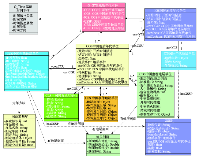
Fig. 2 Semantic representations of Geologic Time Scale Ontology modules

图2 地质年代本体模型概念语义表达

各地质年代单位相互之间通过来自基础时间本体的时间拓扑关系“intMeets”(时间段相接)等建立时态关联,并通过“cor.CCU”(“对应的中国年代地层单位”)等关系谓词建立与各地层单位的关联。同时,地层单位又通过“hasGSSP”与GSSP概念相关联。基于相互之间的语义关联,建立起各概念之间的语义关联网络。
版本信息、概念多语言注释(标注)也是地质年代概念的重要属性。不同版本概念其定义、属性既有区别又有联系。本文采用DCMI中的“terms:hasVersion”来表示一个概念的版本信息,并定义关系“hasNewVersion”与“hasOldVersion”来表达概念的新旧版本,规定没有变化的概念不需要对URI中的版本信息做出更新。相对于GTS本体[15]的版本表达方式,这种方式不仅便于对概念进行更新,同样便于对概念进行版本追溯和版本信息提取。对于概念多语言标注,本文借鉴Ma等[8]的方法,使用SKOS中的“altLabel”与“prefLabel”来表示概念多语言标注,并使用“xml:lang”来表示语言类型。

3.3 时间信息语义表达

时间是地质年代本体概念的本质属性。地质年代本体中的时间语义表达包括二个方面,即时间属性的表达(如地质年龄)和时间拓扑关系的表达。
3.3.1 时间属性表达
地质年代单位起止时间、生物始现或绝灭时间等可认为是时间点;事件持续时间、旋回周期等可认为是时间段。因而时间属性的语义表达主要指地质年龄及其时间误差等点信息,和持续时间、间隔时间与重叠时间等段信息的属性值及相关的定年方法、地层剖面点位等信息的表达。使用简单的文字或数字难以表达如此丰富的时间属性内容。为此,本文采用以时间描述对象为中心的RDF(Resource Description Framework)链实现时间属性的表达(图3)。1个地质年代概念实体可有多个时间描述对象(如“开始时间”、“生物始现时间”),而每一时间描述对象可有时间坐标系类型(如B.P.(Before Present)等)和单位、测年方法等对象属性以及时间误差等数值属性。时间值对象通过“hasValue”等关系谓词来表达具体的时间值和时间单位属性。根据时间计算精度及应用需要,时间值对象及持续时间等时间距离可以用一个时间粒度进行描述(如“1.806 Ma”),或采用不同粒度的组合进行描述(如“1 Ma,806 Ka”)。
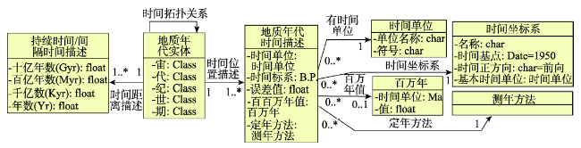
Fig. 3 Semantic representations of temporal properties of a geo-data object

图3 地学数据对象时间属性语义表达

相比使用数据属性以字符串形式表达时间信息的方式,用时间概念对象表达时间属性这种多数地质年代本体采用的方法,虽然相对复杂,但更便于扩展和提取时间信息,可表达更丰富的时间语义。
3.3.2 时间拓扑关系表达
时间拓扑关系是实现时态推理的基础,其描述地学现象或过程在时间上的相关关系,是时间语义关系的子集。地质年代单位之间的先后、包含关系,古生物种类与其始现与灭亡时间、生存年代的关系,地质事件与其发生年代的关系等都属于时间拓扑关系。侯志伟等[30]基于时间区间代数扩展了一系列时间段、时间点之间的时间拓扑关系描述,主要包括相接、相离、相交、相等和包含5类关系及早于、晚于等衍生关系。本文采用其方法进行时间拓扑关系描述,具体内容包含于基础时间本体之中。

4 本体的构建与应用

4.1 地质年代本体构建

本体构建是本体由概念模型向工程应用过渡的关键步骤。本体的构建将产生一系列相关的OWL或RDF文件,便于分发和应用程序解析、应用。在借鉴吸收七步法[36]、模块化本体构建方法[37]及本体论开发步骤[38]的基础上,本文采用了一种本体模块化构建流程。多模块的划分使本体结构清晰、关系明确,便于复用、维护和团队分工协作,保证了本体构建的高效性和科学性。具体流程如图4所示。
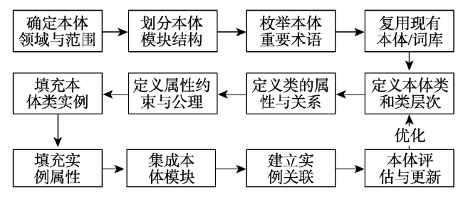
Fig. 4 Procedures of ontology construction

图4 本体构建流程

本文以《中国地层表》和《国际年代地层表》的中、英、法、日等多个语言版本及GSSP表(③ https://engineering.purdue.edu/Stratigraphy/gssp/index.php?parentid=all。)作为地质年代本体的重要术语来源,同时参照地层表说明等资料及表2图2图3中的本体设计,将本体划分为多个模块,并完成类的定义与类的层次结构划分。最终使用Protégé软件完成类及类属性、关系和实例、约束等内容的定义、生成和关联操作,初步构建完成了地质年代本体。目前共完成宙、代、宇、界等120个类,显生宙、新生代等1988个实例及几十种各类型对象属性与数据属性的构建,并为绝大多数属性定义了取值类型、个数与范围约束。本体中主要的类及其关系使用Protégé的OntoGraf插件展示如 图5所示。
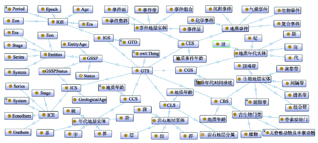
Fig. 5 Classes of GTSO built with Protégé

图5 地质年代本体类关系图

图5中,GTS为地质年代本体根类,CGS等为对应各个子模块的子类,具体含义及属性如图2所示。ICE、IGE、地质年代实体等类为概念实体类,其概念实例的时间描述信息由GTD与地质年代时间描述等辅助类中实例提供。

4.2 地质年代本体应用案例

4.2.1 地质年代概念语义查询
知识图谱的一个主要应用是概念语义查询。这对于增强用户对地质年代知识的理解,解决异词同义等语义异构问题,促进知识的有效利用有重要意义。以“新近纪”概念查询为例,系统先对术语“新近纪”进行语义解析,查询获得本体中对应概念与定义、多语言标注等属性,并通过“owl:sameAs”和“owl:differentFrom”或“owl:AllDifferent”声明获取等价和非等价概念。然后,根据如式(2)、(3)所示规则(采用Apache Jena(④ http://jena.apache.org/)规则语法)进行语义推理,获得起止时间属性和不同层级的地质年代、地层、地质事件、GSSP等概念和概念属性。
[(?a TimeRela:intContains ?b)(?b TimeRela:
intContains ?c)->(?a TimeRela:intContains ?c)] (2)
[(?a TimeRela:intContains ?b) (?b CGS:有地质
事件 ?c) -> (?a CGS:有地质事件 ?c)] (3)
查询结果经过转换最终以知识卡片的形式展现给用户。概念属性等结构化知识可以表格形式展现,地质年代概念之间的层级关系则以动态树状图的方式进行展示,而地质年代关联的地层、地质事件和古生物、GSSP等概念中包含的丰富空间信息,可结合WebGIS技术实现地理可视化。
4.2.2 地学数据语义检索
自然语言存在的语义歧义和数据间缺少关联的现实,使基于关键词匹配的数据检索功能难以满足日益复杂的应用需求[39]。本文采用一种结合本体和全文检索技术的语义检索方法,基于本体对一词多义及概念间显性和隐性关联进行形式化处理和语义推理,经过语义转换、本体解析、推理、查询等过程对输入的检索条件进行响应,能获得比关键词检索更好的效果[11]。本文从百度学术、地球系统科学数据共享平台、东亚古环境科学数据库等整理了200余条地质年代相关中英文文献和数据集元数据进行试验。部分数据检索结果如图6所示。
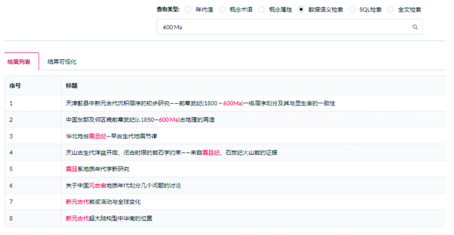
Fig. 6 Results of semantic geodata retrieval

图 6 地学数据语义检索结果

图6可发现,直接使用地质年代时间值进行查询时,本文实现的数据语义检索方法,不仅获得了字面上完全匹配的数据,还通过时态语义推理,获得了600 Ma所对应的地质年代单位概念震旦纪、新元古代、元古宙的相关数据。而传统的全文检索结果无法获得任何与时间值对应的地质年代概念相关的数据。显然地,语义检索所得结果更符合用户需求,说明本文的方法能够较好的理解用户搜索意图,具有一定的关联数据发现和数据推荐能力。由图7可发现,使用地质年代概念作为检索关键词时,在概念多语言注释的帮助下,可获得中文、日语、英语等不同语言的数据结果。此外,在本体的支持下,还可同时检索获得“大湾阶”及等价的“大坪阶”概念的数据。术语变更已不再是人们获取数据的阻碍。由此可见,本文的方法解决了由于多语言和概念更新等造成的异词同义等语义异构问题,弥补了关键词检索在发现等价语义概念数据方面的不足。
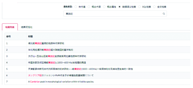
Fig. 7 Results of Cambrian Period semantic retrieve

图7 寒武纪语义查询结果

5 结论

解决地质年代概念和地学数据中普遍存在的语义异构问题,建立各概念之间及概念与数据之间的语义关联,对于提升地学概念和数据的查询检索效果,促进数据集成、共享等都有重要作用。国内外学者对地质年代本体的构建与应用研究,缺少对中国地质年代和地层划分的本体表达及其与国际地质年代和地层划分的关系的分析。为此,本文建立了由基础层、核心层和应用层组成的,以中国和国际地质年代与地层系统、GSSP等为主要内容的多模块地质年代本体。对地质年代概念和时间语义的表达方法进行了详细的设计。探索了地质年代本体在地学知识图谱和数据语义检索中的应用方法,设计开发了具有本体解析、存取、查询等功能的应用系统。实验结果表明,本研究建立的地质年代本体,建立了不同概念间的语义关联,较完整地表达了地质年代概念的语义信息,为快速而准确地发现地学研究与应用所需的地学知识与数据,提供了一种科学有效的方法。所提出的语义检索方法,不仅提高了检索效果,同时保证了检索工具的实用性和高效性,尤其对于领域专题数据库,具有一定的理论和应用价值。
本体的应用效果如何,很大程度上取决于本体库的规模。因此,在后续研究中,需进一步完善地质年代本体结构和数据,补充地层剖面、古生物化石、地质图、古地理重建图等各类知识和数据,形成较完善的大规模的地质年代知识图谱。此外,还需对时间语义相似度、相关度的计算和数据语义标注方法等进行研究,提高数据检索等应用的准确度;而在应用方面,开展与各类地学数据共享平台的系统集成方法研究,向外开放知识查询服务接口,为社区提供知识服务。增加对概念属性信息的多语言标注,并建立与国际上现有地质年代本体的概念与关系映射,实现成果的国际化应用,也是后续需要研究的问题。

The authors have declared that no competing interests exist.

[1]
万晓樵,王成善,吴怀春,等.从地层到地时[J].地学前缘,2014,21(2):1-7.

[ Wan X Q, Wang C S, Wu H C, et al.From stratigraphy to Earthtime[J]. Earth Science Frontiers, 2014,21(2):1-7. ]

[2]
陈宣华,董树文,史静.地质年代学发展历史的简要回顾及前景[J].世界地质,2009,28(3):384-96.lt;p>根据全国性煤炭矿产资源潜力数据库的建设要求, 设计了系统的功能模型; 并在充分考虑其他矿种的前提下, 建立了基于Oracle Spatial和Geodatabase的煤炭空间数据模型, 使用SDO-GEOMETRY 类型字段保存GIS的空间数据, 采用面向对象程序设计语言C#和ArcObjects组件的二次开发实现了该系统。应用结果表明, 本系统不但达到了预期目标, 并能为可供性分析等系统提供有效的数据支持。</p>

DOI

[ Chen X H, Dong S W, Shi J.Brief review and prospect of geochronological development[J]. Global Geology, 2009,28(3):384-96. ]

[3]
邬宽廉,左群超,邬可筠.建立地质图数据库的地质年代代码问题[J].地质通报,2008,27(7):1103-6.在建立全国1:50万地质图数据库的工作中,根据使用的需要,对原有国家标准中的地质年代代码做了改编,使之适用于按地质年代进行任意检索和各种统计.按不同需要对各种面元进行合并.根据年代代码由计算机自动生成所需的面色、花纹和地质符号等。近10年来的应用证明效果良好。结合国外的情况,建议以地质年龄为主体编制地质年代代码。

DOI

[ Wu K L, Zuo Q C, Wu K Y.Problems in the codes of geological ages in the process of establishment of the geological map database[J]. Geological Bulletin of China, 2008,27(7):1103-1106. ]

[4]
Cox S J, Richard S M.A formal model for the geologic time scale and global stratotype section and point, compatible with geospatial information transfer standards[J]. Geosphere, 2005,1(3):119-37.The geologic time scale is a complex data structure composed of abstract elements that represent time intervals and instants and their relationships with specific concrete representations in the geologic record as well as the observations made of those concrete representations. The International Union of Geological Sciences9 International Commission on Stratigraphy guidelines recommends a very precise usage of the relationships between these components in order to establish a standard time scale for use in global correlations. However, this has been primarily described in text. Here, we present a formal representation of the model using the Unified Modeling Language (UML). The model builds on existing components from standardization of geospatial information systems. The use of a formal notation enforces precise definition of the relationships between the components. The UML platform also supports a direct mapping to an eXtensible Markup Language (XML) ased file format, which may be used for the exchange of stratigraphic information using Web-service interfaces.

DOI

[5]
樊隽轩,张华,侯旭东,等.古生物学和地层学研究的定量化趋势——GBDB数字化科研平台的建设及其意义[J].古生物学报,2011,50(2):141-53.自上世纪八十年代末以来,基于数据库和各种定量分析方法的古生物学、地层学、古地理学、古生态学研究逐渐成为当今国际地学研究的前沿和热点。中国的古生物学和地层学数字化科研平台的建设,最早的设计思路始于2001年,于2003年进行了首次尝试,并于2007年整合了多种相关数据资源,正式启动了GeoBiodiversity database(GBDB)这一古生物学和地层学数字化科研平台的建设。在这一平台中,目前已整合了古生物分类数据、剖面地理信息数据、岩石地层数据、化石产出数据、生物地层数据、文献数据等多项数据资源,同时还结合科学研究和生产应用的需求开发了地理信息可视化和地层信息可视化功能,以及初步的多样性分析和定量地层对比功能。这一平台的最终建设目的,是成为科学家和相关人员使用古生物学和地层学数据,开展各种定性和定量分析的国际化、网络化的科研辅助平台。

[ Fan J X, Zhang H, Hou X D, et al.Quantitative research trends in Palaeobiology and Stratigraph - Construction of the GeoBiodiversity Database (GBDB) using e-science technology[J]. Acta Palaeontologica Sinica, 2011,50(2):141-153]

[6]
董少春,尹宏伟,许刚.地质时间本体在异构数据检索中的应用[J].地球信息科学学报,2010,12(2):194-199.地质时间是地球科学基础研究的重要内容,在异构数据集和文献中有多种描述方式,其语义异构问题成为影响数据共享与集成的瓶颈之一。本体(Ontology)是共享概念模型的明确的形式化规范说明,可以用来描述数据的语义信息,近年来,被广泛应用于解决语义异构问题。本文以地质时间作为研究对象,分析了地质时间这一特定领域蕴含的基本概念、属性和关系,构建了地质时间的领域本体和OWL的编码表达,并以关系型数据库为例,阐述了地质时间本体的语义映射和翻译机制。该机制能够有效地在W eb环境下为传统数据检索增强语义表达能力,识别地质时间不同表达方式中的等价、包含等隐含关系,实现语义的数据检索。该方法也适用于地球科学其他领域本体的构建和语义翻译,为解决地球科学数据的语义异构问题提供了思路。

[ Dong S C, Yin H W, Xu G.Application of geologic time ontology in heterogeneous data searching[J]. Journal of Geo-Information Science, 2010,12(2):194-199. ]

[7]
李学军. 地学论文中常见的表达问题及解决方法和建议[J].中国科技期刊研究,2011,22(5):779-83.

[ Li X J.Solutions and suggestions for common expression problems in geoscience papers[J]. Chinese Journal of Scientific and Technical Periodicals, 2011,22(5):779-83. ]

[8]
Ma X, Carranza E J M, Wu C, et al. A SKOS-based multilingual thesaurus of geological time scale for interoperability of online geological maps[J]. Computers & Geosciences, 2011,37(10):1602-1615.The usefulness of online geological maps is hindered by linguistic barriers. Multilingual geoscience thesauri alleviate linguistic barriers of geological maps. However, the benefits of multilingual geoscience thesauri for online geological maps are less studied. In this regard, we developed a multilingual thesaurus of geological time scale (GTS) to alleviate linguistic barriers of GTS records among online geological maps. We extended the Simple Knowledge Organization System (SKOS) model to represent the ordinal hierarchical structure of GTS terms. We collected GTS terms in seven languages and encoded them into a thesaurus by using the extended SKOS model. We implemented methods of characteristic-oriented term retrieval in JavaScript programs for accessing Web Map Services (WMS), recognizing GTS terms, and making translations. With the developed thesaurus and programs, we set up a pilot system to test recognitions and translations of GTS terms in online geological maps. Results of this pilot system proved the accuracy of the developed thesaurus and the functionality of the developed programs. Therefore, with proper deployments, SKOS-based multilingual geoscience thesauri can be functional for alleviating linguistic barriers among online geological maps and, thus, improving their interoperability.

DOI

[9]
诸云强,孙九林.面向e-GeoScience 的地学数据共享研究进展[J].地球科学进展,2006,21(3):286-90.lt;p>在总结比较国内外e-GeoScience研究进展的基础上,介绍了中国科学院地理科学与资源研究所自20世纪80年代以来开展的相关工作。提出了按&ldquo;圈层&mdash;学科&mdash;数据类别&rdquo;三级模式的地球系统科学数据分类体系,以主体数据库为核心,初步构建了&ldquo;主体数据库&mdash;数据资源点&rdquo;为支撑的地球系统科学数据资源体系。在J2EE环境下,采用Web Services、地理信息等技术开发了地球系统科学数据共享平台。最后,探讨了e-GeoScience未来的研究方向。</p>

DOI

[ Zhu Y Q, Sun J L.The research progress in Geo-data sharing based on e-GeoScience[J]. Advances in Earth Sciences, 2006,21(3):286-290. ]

[10]
Studer R, Benjamins V R, Fensel D.Knowledge engineering: Principles and methods[J]. Data & Knowledge Engineering, 1998,25(s1-2):161-197.This paper gives an overview of the development of the field of Knowledge Engineering over the last 15 years. We discuss the paradigm shift from a transfer view to a modeling view and describe two approaches which considerably shaped research in Knowledge Engineering: Role-limiting Methods and Generic Tasks. To illustrate various concepts and methods which evolved in recent years we describe three modeling frameworks: CommonKADS, MIKE and PROT G -II. This description is supplemented by discussing some important methodological developments in more detail: specification languages for knowledge-based systems, problem-solving methods and ontologies. We conclude by outlining the relationship of Knowledge Engineering to Software Engineering, Information Integration and Knowledge Management.

DOI

[11]
邓志鸿,唐世渭,张铭,等.Ontology 研究综述[J].北京大学学报(自然科学版),2002,38(5):730-738.Ontology是描述概念及概念之间关系的概念模型,通过概念之间的关系来描述概念的语义。作为一种有效表现概念层次结构和语义的模型,Ontology被广泛地应用到计算机科学的众多领域。本文作者对目前Ontology的研究与应用现状进行了综述性地介绍,从Ontology的定义Ontology理论研究、Ontology在信息系统中的应用以及在语义Web中的地位等方面加以了系统阐述。

[ Deng Z H, Tang S W, Zhang M, et al.Overview of ontology[J]. Acta Scientiarum Naturalium Universitatis Pekinensis, 2002,38(5):730-738. ]

[12]
Ma X, Fox P.Recent progress on geologic time ontologies and considerations for future works[J]. Earth Science Informatics, 2013,6(1):31-46.Semantic Web technologies bring innovative ideas to computer applications in geoscience. As an essential part of the Semantic Web, ontologies are increasingly discussed in the geoscience community, in which geologic time scale is one of the topics that have received the most discussion and practices. This paper aims to carry out a review of the recent progress on geologic time ontologies, discuss further improvements, and make recommendations for other geoscience ontology works. Several models and ontologies of geologic time scale are collected and analyzed. Items such as ontology evaluation, ontology mapping, ontology governance, ontology delivery and multilingual labels are discussed for advancing the geologic time ontologies. We hope the discussion can be useful for other geoscience ontology works, and we also make a few further recommendations, such as referring to an ontology spectrum in ontology creation, collaborative working to improve interoperability, and balancing expressivity, implementability and maintainability to achieve better applications of ontologies.

DOI

[13]
Richard S M, Boisvert E, Brodaric B, et al.GeoSciML - A GML Application for Geoscience Information Interchange[J]. Philadelphia Annual Meeting, 2007:47-59.ABSTRACT

DOI

[14]
Ma X, Carranza E J M, Wu C, et al. Ontology-aided annotation, visualization, and generalization of geological time-scale information from online geological map services[J]. Computers & geosciences, 2012,40:107-119.Geological maps are increasingly published and shared online, whereas tools and services supporting information retrieval and knowledge discovery are underdeveloped. In this study, we developed an ontology of geological time scale by using a Resource Description Framework model to represent the ordinal hierarchical structure of the geological time scale and to encode collected annotations of geological time scale concepts. We also developed an animated graphical view of the developed ontology, and functions for interactions between the ontology, the animation and online geological maps published as layers of OGC Web Map Service. The featured functions include automatic annotations for geological time concepts recognized from a geological map, changing layouts in the animation to highlight a concept, showing legends of geological time contents in an online map with the animation, and filtering out and generalizing geological time features in an online map by operating the map legend shown in the animation. We set up a pilot system and carried out a user survey to test and evaluate the usability and usefulness of the developed ontology, animation and interactive functions. Results of the pilot system and the user survey demonstrate that our works enhance features of online geological map services and they are helpful for users to understand and to explore geological time contents and features, respectively, of a geological map.

DOI

[15]
徐增林,盛泳潘,贺丽荣,等.知识图谱技术综述[J].电子科技大学学报,2016,45(4):589-606.

[ Xu Z L, Sheng Y P, He L R, et al.Review on techniques of knowledge graph[J]. Journal of University of Electronic Science and Technology of China, 2016,45(4):589-606. ]

[16]
刘峤,李杨,段宏,等.知识图谱构建技术综述[J].计算机研究与发展,2016,53(3):582-600.谷歌知识图谱技术近年来引起了广泛关注,由于公开披露的技术资料较少,使人一时难以看清该技术的内涵和价值.从知识图谱的定义和技术架构出发,对构建知识图谱涉及的关键技术进行了自底向上的全面解析.1)对知识图谱的定义和内涵进行了说明,并给出了构建知识图谱的技术框架,按照输入的知识素材的抽象程度将其划分为3个层次:信息抽取层、知识融合层和知识加工层;2)分别对每个层次涉及的关键技术的研究现状进行分类说明,逐步揭示知识图谱技术的奥秘,及其与相关学科领域的关系;3)对知识图谱构建技术当前面临的重大挑战和关键问题进行了总结.

DOI

[ Liu Q, Li Y, Duan H, et al.Knowledge graph construction techniques[J]. Journal of Computer Research and Development, 2016,53(3):582-600. ]

[17]
Cox S J D, Richard S M. A geologic timescale ontology and service[J]. Earth Science Informatics, 2015,8(1):5-19.We have developed an OWL ontology for the geologic timescale, derived from a Unified Modeling Language (UML) model that formalized the practice of the International Commission for Stratigraphy (ICS) (Cox and Richard 2005 ). The UML model followed the ISO/TC 211 modeling conventions, and was the basis for an XML implementation that was integrated into GeoSciML 3.0. The OWL ontology is derived using rules for generating OWL ontologies from ISO-conformant UML models, as provided in a (draft) standard from ISO/TC 211 . The basic ontology is also aligned with SKOS to allow multilingual labels, and to enable delivery through a standard vocabulary interface. All versions of the International Stratigraphic Chart from 2004 to 2014 have been encoded using the ontology. Following ICS practice, the elements of the timescale retain the same identifiers across the multiple versions, though the information describing each geochronologic unit evolves with the versions of the timescale. The timescales are published through multiple web interfaces and APIs.

DOI

[18]
Perrin M, Mastella L S, Morel O, et al.Geological time formalization: an improved formal model for describing time successions and their correlation[J]. Earth Science Informatics, 2011,4(2):81-96.Geological time description largely rests on an event based chronology based on the stratigraphical model . It uses a hierarchy of chronologically ordered geochronological units and boundaries . In order to be easily dealt with within large databases used by complex engineering systems, the geological time chronology must be formalized. Stratigraphical time successions should accordingly be described by using adequate semantic tools (ontologies) complemented by a set of logical rules. At present, geological time formalization mainly rests on the GeoSciML model. This model is fit for describing individual geological time scales but does not provide all the necessary tools for comparing various time successions and for operating full stratigraphic correlations. For complementing the GeoSciML model, we define two ontologies for geological time description and for geological dating. They extend the GeoSciML model, so that it becomes possible to fully use the Allen rules for operating time correlations between any couple of time scales or stratigraphic successions. We additionally propose a codification resting on the defined ontologies, which allows operating all age identification and correlation by means of simple computation rules.

DOI

[19]
Raskin R G, Pan M J.Knowledge representation in the semantic web for Earth and environmental terminology (SWEET)[J]. Computers & Geosciences, 2005,31(9):1119-1125.The semantic web for Earth and environmental terminology (SWEET) is an investigation in improving discovery and use of Earth science data, through software understanding of the semantics of web resources. Semantic understanding is enabled through the use of ontologies, or formal representations of technical concepts and their interrelations in a form that supports domain knowledge. The ultimate vision of the semantic web consists of web pages with XML namespace tags around terms, enabling search tools to ascertain their meanings by following the link to the defining ontologies. Such a scenario both reduces the number of false hits (where a search returns alternative, unintended meanings of a term) and increases the number of successful hits (where searcher and information provider have a syntax mismatch of the same concept). For SWEET, we developed a collection of ontologies using the web ontology language (OWL) that include both orthogonal concepts (space, time, Earth realms, physical quantities, etc.) and integrative science knowledge concepts (phenomena, events, etc.). This paper describes the development of a knowledge space for Earth system science and related concepts (such as data properties). Some of the ontology contents are irtual by means of an OWL wrapper associated with terms in large external databases (including gazetteers and Earthquake databases). We developed a search tool that finds alternative search terms (based on the semantics) and redirects the expanded set of terms to a search engine.

DOI

[20]
Allen J F.Maintaining knowledge about temporal intervals[J]. Communications of the ACM, 1983,26(11):832-843.We have described a system for reasoning about temporal intervals that is both expressive and computationally effective. The representation captures the temporal hierarchy implicit in many domains by using a hierarchy of reference intervals, which precisely control the amount of deduction performed automatically by the system. This approach is partially partially useful in domains where temporal information is imprecise and relative, and techniques such as dating are not possible.

DOI

[21]
Hobbs J R, Pan F.Time Ontology in OWL. 2006, Time Ontology in OWL. 2006, .

[22]
Laxton J, Serrano J-J, Tellez-Arenas A.Geological applications using geospatial standards: An example from OneGeology-Europe and GeoSciML[J]. International Journal of Digital Earth, 2010,3(1):31-49.The Geoscience Markup Language (GeoSciML) has been developed to enable the interchange of geoscience information, principally that portrayed on geological maps as well as boreholes. A GeoSciML testbed was developed both to test the implementation of the data model and its application in web services. The OneGeology-Europe project aims to use the GeoSciML data model, and build on the experience of the GeoSciML testbed, in implementing a geoportal for a harmonised geological map of Europe at 1:1 million scale. This involves the integration of web services from 20 participating organisations. An important objective of OneGeology-Europe is to contribute to Infrastructure for Spatial Information in the European Community (INSPIRE), both through the development of a geological data specification and the use of the INSPIRE technical architecture. GeoSciML and the OneGeology-Europe project are also steps towards incorporating geoscience data into a Digital Earth. Both the development of GeoSciML and the implementation of web services for GeoSciML and OneGeology-Europe, have followed a standards-based methodology. The technical architecture comprises a geoportal providing access to a Catalogue Service for the Web for metadata describing both the data and services available. OneGeology-Europe will provide both Web Map Services view and Web Feature Services download services, which aim to be compliant with the INSPIRE implementing rules.

DOI

[23]
吴立新,徐磊,车德福.地层本体及其在大区域钻孔数据集成中的应用[J].武汉大学学报·信息科学版,2008,33(2):144-148.简要介绍了地学本体论与地学本 体的发展脉络,分析了地学本体的组成及其层次结构,提出了作为地层本体重要实例的沉积地层应用本体的设计方法,通过地层本体的定义及其应用本体的属性分析 与选择,讨论了地层本体的语义内容、语义关系及其BNF范式表达方法,并以苏皖交界地区张夏组沉积地层连接为例,介绍了地层本体与沉积地层本体实例及其在 大区域钻孔数据集成与地层关系判断中的应用。

[ Wu L X, Xu L, Che D F.Stratum-Ontology and its application in bore-hole data integration[J]. Geomatics and Information Science of Wuhan University, 2008,33(2):144-148. ]

[24]
熊义辉,汪新庆,李国庆.地层时空拓扑关系的计算机自动检查设计与实现[J].国土资源遥感,2016,28(1):197-202.lt;p>为了实现对地质图中地层时空拓扑关系的计算机自动检查,以湖北省宜昌市地质建造构造图为例,应用地层学知识剖析了研究区地层的时空特性,建立了地层时空拓扑关系检查规则集,采用VC<sup>++</sup>语言对MapGIS6.7进行二次开发,实现了地层时空拓扑关系的计算机自动检查功能,并将该功能模块嵌入到&quot;全国矿产资源潜力评价项目&quot;数据模型使用软件GEOMAG中,对地质建造构造图进行了空间数据库质量检查。结果表明,应用该模块可以准确地判定地质图中地层的时空拓扑关系,有效地提高了地质图件空间数据库的质量。</p>

DOI

[ Xiong Y H, Wang X Q, Li G Q.Design and realization of computer automatic checking of the stratigraphic spatio- temporal topological relationships[J]. Remote Sensing for Land & Resources, 2016,28(1):197-202. ]

[25]
全国地层委员会.中国地层表[J].地球学报,2014,35(3):附图1.

[ National Commission on Stratigraphy of China, The Stratigraphic Chart of China ( Illustration 1)[J]. Acta Geoscientica Sinica, 2014,35(3): Attached map 1. ]

[26]
Cohen K M, Finney S C, Gibbard P L, et al.The ICS International Chronostratigraphic Chart[J]. Episodes, 2013,36(3):199-204.The International Commission on Stratigraphy (ICS) has a long tradition of producing international charts that communicate higher-order divisions of geological time and actual knowledge on the absolute numerical ages of their boundaries. The primary objective of ICS is to define precisely a global standard set of time-correlative units (Systems, Series, and Stages) for stratigraphic successions worldwide. These units are, in turn, the basis for the Periods, Epochs and Ages of the Geological Time Scale. Setting an international global standard is fundamental for expressing geological knowledge. It is also of considerable pragmatic importance as it provides the framework through which regional-scale higher-resolution divisions can be linked, equated and collated. This is a status update on the International Chronostratigraphic Chart and the ICS website www.stratigraphy.org.

[27]
刘德良. 地球科学中时间段的定年问题——一种不同于地球化学的地球物理定年方法[J]. 中国科学技术大学学报,2011,41(1):1-8.

[ Liu D L.Duration measurement in geological sciences : A geophysical approach[J]. Journal of University of Science and Technology of China, 2011,41(1):1-8. ]

[28]
柳成志,赵荣,赵利华.地球科学概论[M].北京:石油工业出版社,2006.

[ Liu C Z, Zhao R, Zhao L H.Introduction to earth science[M]. Beijing: Petroleum Industry Press, 2006. ]

[29]
王泽九,黄枝高,姚建新,等.中国地层表及说明书的特点与主要进展[J].地球学报,2014,35(3):271-276.

[ Wang Z J, Huang Z G, Yao J X, et al.Characteristics and main progress of the stratigraphic chart of China and directions[J]. Acta Geoscientica Sinica, 2014,35(3):271-276. ]

[30]
侯志伟,诸云强,高星,等.时间本体及其在地学数据检索中的应用[J].地球信息科学学报,2015,17(4):379-390.lt;p>高效、准确地获取目标数据及其关联数据,是决定大数据共享与挖掘分析能否实现的关键因素。传统的数据检索方法无法利用地学数据间的显性或隐含关系,已不能满足日益增长的对检索结果质和量的需求,而本体理论和技术的语义检索成为当前的研究热点。本文针对时间这一地学数据的本质属性,在系统研究地学数据时间概念与特征的基础上,建立了地学数据时间本体模型,并深入论述了模型中的时间关系、时间坐标系等内容,提出了时间位置和时间距离的描述函数,同时研究了二者的本体表达方式。构建了包括地质年代等在内的地学数据时间本体库,并以语义网开发框架Jena为基础,经本体解析、元数据时间信息抽取与标注等过程,将时间本体应用于地球系统科学数据共享平台的元数据检索之中。结果表明,以时间本体的地学数据语义检索查全率约为关键字方法的1倍,检索结果排序,以及关联数据推荐方面也有更好的效果,为促进地学数据共享与关联发现提供了一种有效的方法。</p>

DOI

[ Hou Z W, Zhu Y Q, Gao X, et al.Time-ontology and its application in geodata retrieval[J]. Journal of Geo-information Science, 2015,17(4):379-390. ]

[31]
龚一鸣,张克信.地层学基础与前沿[M].武汉:中国地质大学出版社,2007.

[ Gong Y M, Zhang K X.Basics and frontiers in stratigraphy[M]. Wuhan: China University of Geosciences Press, 2007. ]

[32]
彭善池. 全球标准层型剖面和点位(“金钉子”)和中国的“金钉子”研究[J].地学前缘,2014,21(2):8-26.国际年代地层表》中显生宇所有的年代地层(地质年代)单位和元古宇的部分年代地层(地质年代)单位都已经或将要由全球标准层型剖面和点位("金钉子")定义。这是研发一个完全连续的、既无重复也无间断的年代地层(地质年代)等级系统的唯一途径。文中回顾了过去近50年在国际地层委员会倡导和推行下"金钉子"概念形成和发展过程,简介了"金钉子"概念和由国际地层委员会制定建立"金钉子"的程序;同时简要回顾了中国科学家研究"金钉子"的历史和卓越成就,包括竞争"金钉子"中的失利和收获10枚确立在我国的"金钉子"。

DOI

[ Peng S C.Global standard stratotype-section and points (GSSP, "Golden Spike") and the GSSP research in China[J]. Earth Science Frontiers, 2014,21(2):8-26. ]

[33]
龚一鸣,史晓颖.关于时间、沉积与地层学的几点思考[J].地学前缘,2014,21(2):27-35.地层学与其他自然科学中的时间概念可区分为存在的时间和演化的时间两类,地层学就是依据这两类时间概念和标志构建地质学的时间坐标。选定百万年为地质学的基本时间单位在某种意义上来说是地层学的武断和盲从,它 8.刘成英朱日祥.试论峨眉山玄武岩的地球动力学含义[J]. 地学

DOI

[ Gong Y M, Shi X Y.Thinking on time, sedimentation and stratigraphy[J]. Earth Science Frontiers, 2014,21(2):27-35. ]

[34]
李霖,朱海红,王红,等.基于形式本体的基础地理信息语义分析——以陆地水系要素为例[J].测绘学报,2008,37(2):230-235.以国家基础地理信息中陆地水系要素为案例,讨论其规范定义中语义描述的模糊性。鉴于本体被认为是一种克服语义屏障的有效方法,本文基于形式本体的原理,提出一种对地理信息形式化语义分析的范例方法,即在概念化的基础上,利用属性组来表达概念语义,通过定义概念的本体属性来明确及规范化地表达概念的语义。通过具体分析,本文给出基础地理信息陆地水系要素的形式化语义。

DOI

[ Li L, Zhu H H, Wang H, et al.Semantic analyses of the fundamental geographic information based on formal ontology: Exemplifying hydrological category[J]. Acta Geodaetica et Cartographica Sinica, 2008,37(2):230-235. ]

[35]
钟秀琴,刘忠,丁盘苹.基于混合推理的知识库的构建及其应用研究[J].计算机学报,2012,35(4):761-766.

[ Zhong X Q, Liu Z, Ding P P.Construction of knowledge based on hybrid reasoning and its application[J]. Chinese Journal of Computers, 2012,35(4):761-766. ]

[36]
Noy N F, McGuinness D L. Ontology development 101: A guide to creating your first ontology[M]. Stanford knowledge systems laboratory technical report KSL-01-05 and Stanford medical informatics technical report SMI-2001-0880. 2001.

[37]
冯兰萍,朱礼军,蒋亚东.一种模块化本体构建方法研究[J].现代图书情报技术,2010,26(6):53-59.<p>提出一种通过本体模块的裂变、重组、重用实现模块化本体的构建方法,详细分析该方法实现的流程、模块裂变和模块集成的规则,最后讨论该方法在水资源本体构建中的应用及其构建过程中存在的问题。该方法能够实现模块化本体的细粒度、协作构建,从而提高本体的构建效率和重用能力。</p>

[ Feng L P, Zhu L J, Jiang Y D.Study on a method of building modular onotlogy[J]. New Technology of Library and Information Service, 2010,26(6):53-59. ]

[38]
冯志勇,李文杰,李晓红.本体论工程及其应用[M].北京:清华大学出版社,2007.

[ Feng Z Y, Li W J, Li X H.Ontology engineering and its applications[M]. Beijing: Tsinghua University Press, 2007. ]

[39]
Lutz M, Klien E.Ontology-based retrieval of geographic information[J]. International Journal of Geographical Information Science, 2006,20(3):233-260.Discovering and accessing suitable geographic information (GI) in the open and distributed environments of current Spatial Data Infrastructures (SDIs) is a crucial task. Catalogues provide searchable repositories of information descriptions, but the mechanisms to support GI retrieval are still insufficient. Problems of semantic heterogeneity caused by the ambiguity of natural language can arise during keyword‐based search in catalogues and when formulating a query to access the discovered data. In this paper, we present an approach to ontology‐based GI retrieval that contributes to solving existing problems of semantic heterogeneity and hides most of the complexity of the required procedure from the requester. A query language and graphical user interface allow a requester to intuitively formulate a query using a well‐known domain vocabulary. From this query, an ontology concept is derived, which is then used to search a catalogue for a data source that provides all the information required to answer the requester's query. If a suitable data source is discovered, the relevant data are accessed through a standardized interface. The approach is implemented through several components that can be used as an extension to standard SDIs.

DOI

Outlines

/