
Journal of Geo-information Science >
Analysis on the Characteristics of Change and Recovery of Vegetation Indices for Forests in Burned Area
Received date: 2017-10-03
Request revised date: 2018-01-20
Online published: 2018-03-20
Supported by
National Key Research and Development Program of China, No.2017YFB0504102, 2017YFC1502402
Global Ecosystems and Environment Observation Analysis Report Program, No.1061302600001
National Natural Science Foundation of China, No.41671412
The Fundamental Research Funds for the Central Universities.
Copyright
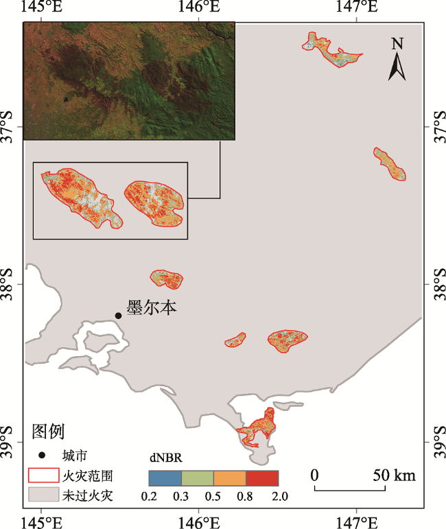
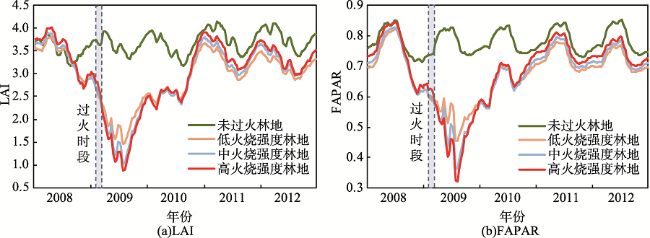
The application of remote sensing technology to study the response and recovery of forest vegetation in burned area can provide scientific basis for quick and accurate disaster prevention and mitigation. We focus on the forest fire occurred in Victoria, Australia from February 7, 2009 to March 14, 2009, which was the most serious forest fire in Victoria. In order to analyze the characteristics of change and recovery of forest vegetation indices in response to forest fire, we first used Landsat5 TM data of pre-fire and post-fire to extract the burned area of Victoria in Australia in 2009 and calculate the burn severity based on the Differential Normalized Burn Ratio (dNBR). We analyzed the effects of forest fire with different burn severity on vegetation using the anomaly value of Leaf Area Index (LAI) and the Fraction of Absorbed Photosynthetically Active Radiation (FAPAR) of Global Land Surface Satellite product(GLASS). Based on the time series data of LAI and FAPAR, we analyzed the vegetation recovery characteristics affected by forest fire with different burn severity. The results showed that LAI, FAPAR can reflect the damage effects of forest fire on vegetation and tract the recovery process of vegetation well. The LAI and FAPAR values decreased rapidly after the forest fire. The greater the burn severity, the higher the decreasing amplitude. The maximum decreasing amplitude of LAI and FAPAR of high burn severity area were 1.2, 1.3 times higher than that of low burn severity area and medium burn severity area, respectively. The LAI and FAPAR values increased over a period of time after the forest fire and restored to normal levels in 2-3 years. The recovery time of LAI and FAPAR is related to fire scale, burn severity, the natural conditions of the burned area, the growth of the original vegetation and other factors. For example, one year after the forest fire in Victoria, the decreasing amplitude of LAI and FAPAR in small burned area was 4.8% of the big burned area. The recovery time of LAI and FAPAR in high burn severity area and big burned area was 1 year or 2 years later than that of low burn severity area and small burned area. This study analyzed the characteristics of the change of the vegetation indices (LAI and FAPAR) of vegetation affected by the forest fire and summarized the recovery characteristics of damaged vegetation in Victoria, which can provide scientific basis for formulation of the measures of forest fire recovery.
Key words: forest fire; vegetation change; vegetation recovery; vegetation index; burn severity; GLASS
LI Jing , GONG Adu , CHEN Yanling , WANG Jingmei , ZENG Tingting . Analysis on the Characteristics of Change and Recovery of Vegetation Indices for Forests in Burned Area[J]. Journal of Geo-information Science, 2018 , 20(3) : 368 -376 . DOI: 10.12082/dqxxkx.2018.170464
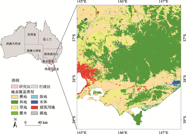
Fig. 1 Location and land cover of the study area图1 研究区位置及地表覆盖 |
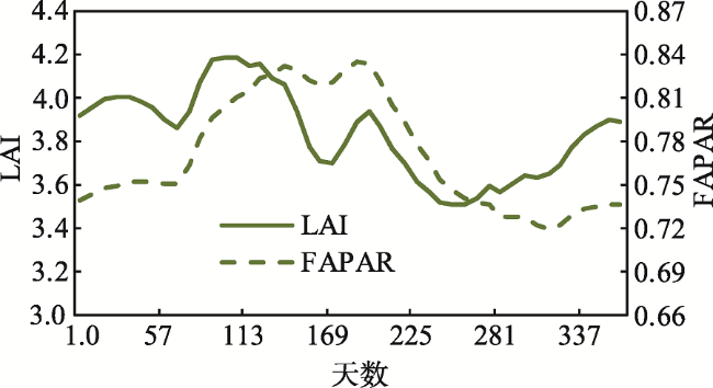
Fig. 2 Changes of LAI and FAPAR in unburned forest area图2 未过火林地LAI、FAPAR年内变化规律 |
Fig. 3 The distribution of burn severity in burned area图3 过火区火烧强度 |
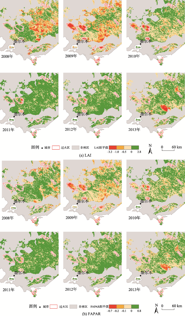
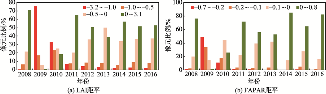
Fig. 4 Spatial distribution of anomaly of remote sensing vegetation indices of the forest in the study area图4 研究区林地植被遥感参数距平值分布 |
Fig. 5 Changes of the anomaly of vegetation indices in the burned area图5 过火区植被遥感参数距平值变化 |
Fig. 6 Changes of vegetation indices in the study area图6 研究区植被遥感参数变化 |
The authors have declared that no competing interests exist.
| [1] |
|
| [2] |
|
| [3] |
|
| [4] |
[
|
| [5] |
[
|
| [6] |
[
|
| [7] |
|
| [8] |
|
| [9] |
|
| [10] |
|
| [11] |
[
|
| [12] |
|
| [13] |
|
| [14] |
[
|
| [15] |
[
|
| [16] |
[
|
| [17] |
[
|
| [18] |
[
|
| [19] |
|
| [20] |
|
| [21] |
[
|
| [22] |
[
|
| [23] |
|
| [24] |
[
|
| [25] |
[
|
| [26] |
[
|
| [27] |
Bushfires in Australia[Z]. 2018-01-13.
|
| [28] |
|
| [29] |
|
| [30] |
[
|
| [31] |
[
|
| [32] |
[
|
| [33] |
|
/
| 〈 |
|
〉 |