
Journal of Geo-information Science >
Typical Spatial Distribution of Merchant Vessels and Trade Flow in South China Sea
Received date: 2017-12-28
Request revised date: 2018-03-22
Online published: 2018-05-20
Supported by
National Natural Science Foundation of China, No.41501490
Key Project of the Chinese Academy of Sciences, No.ZDRW-ZS-2016-6-3
Fujian Provincial Educational Department Fundation, No.JAT160257
Fujian Provincial Teaching Reform Fundation, No.JZ160302
Li Shangda College Fundation, No.ZC2016005.
Copyright
With the deepening of China's opening to the outside world and the advancement of the Belt and Road Initiative, South China Sea, as an important gateway to China's opening-up and a vital joint for important sea-routes gathering in the world, is embodying prominently strategic position. How to ensure the safety of routes and regulate the vessels sailing in the open water of the south China Sea, safeguard national rights and enhance regional trade is a difficult problem for governmental administrators. In this paper, we excavated the typical spatial distribution of vessels by calculating and visualizing the traffic density of navigation in the South China Sea to analyze the main routes selected by full use of the satellite AIS data of South China sea in 2015 and vessel information database, so the habitual routes could be detected in this region. On the other hand, the statistics on the number of vessels in South China Sea were computed by the statistic line set to find the peak points of the vessel crossing data on the main routes being selected by the most of vessels. Via the above steps, the typical spatial distribution of vessels was defined clearly. Meanwhile, the main flow of trades in South China Sea was determined based on 4 dominant sorts (Bulk, Container, Oil&Chemical and Ro-Ro) of vessels' main routes selected. Research indicated that: (1) The main routes followed the authoritative sailing book《Admiralty Ocean Passage for the World》, which provides sailors with the routes consisting of the waypoints recommended. As a result, the construction and development have little influence on the navigation in this region. Maritime safety administrator can set traffic separation scheme efficiently based on this research; (2) Long-distance shipping is the major mode of transportation. Pearl River Delta being one of the main ends of trade flow indicates the China's dominant position in the South China Sea Trade. This research also attracts more attention to the Beibu Gulf and Hainan Island’s trade potentiality.
MEI Qiang , WU Lin , PENG Peng , ZHOU Peng , CHEN Jinhai . Typical Spatial Distribution of Merchant Vessels and Trade Flow in South China Sea[J]. Journal of Geo-information Science, 2018 , 20(5) : 632 -639 . DOI: 10.12082/dqxxkx.2018.180017
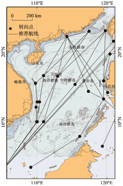
Fig. 1 Main recommended routes for merchant vessels in South China Sea图1 《世界大洋航路》南海区域主要商船推荐航路 |
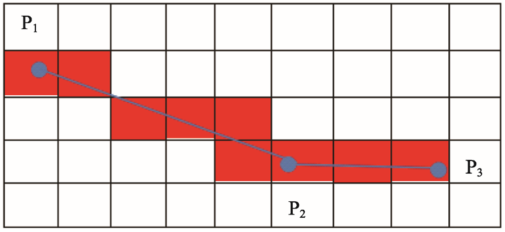
Fig. 2 Schematic diagram of traffic density calculation图2 交通密度计算示意图 |
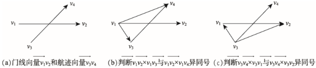
Fig. 3 Flow diagram of judging intersection of and图3 判断与相交流程图 |
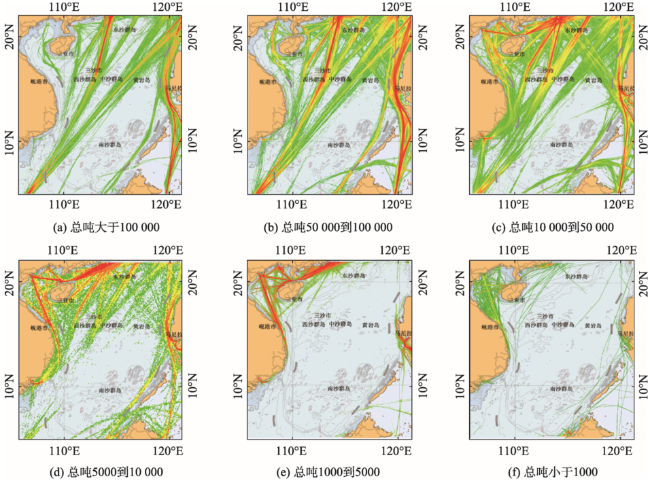
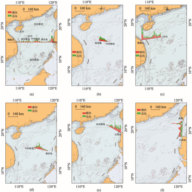
Fig. 4 Traffic density maps of ships' gt in different intervals图4 典型吨位区间船舶的交通密度图 |
Fig. 5 Charts of vessels crossing statistics lines in South China Sea图5 南海船舶通过数量门线统计图 |
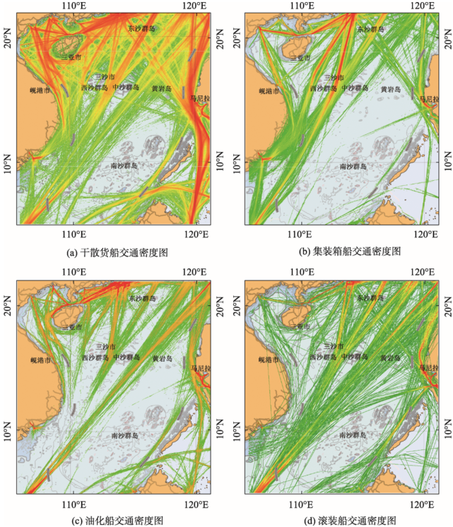
Fig. 6 Traffic density maps of four main types of vessels图6 4种主要船型船舶交通密度图 |
The authors have declared that no competing interests exist.
| [1] |
|
| [2] |
[
|
| [3] |
[
|
| [4] |
[
|
| [5] |
[
|
| [6] |
|
| [7] |
|
| [8] |
[
|
| [9] |
[
|
| [10] |
|
| [11] |
|
| [12] |
|
| [13] |
Admiralty. Ocean passages for the World (NP136)[M]. London: United Kingdom Hydrographic Office. 2014:169-210.
|
| [14] |
中国航海学会,上海海事大学.南海航行研究报告. [ EB/OL]. .
China Institute of Navigation, Shanghai Maritime University. Research Report on Navigation status in the South China Sea[EB/OL]. .
|
| [15] |
|
| [16] |
|
| [17] |
|
| [18] |
中华人民共和国海事局.南中国海至马六甲海峡航行指南[M].北京:人民交通出版社,2017:1-5.
[
|
| [19] |
[
|
| [20] |
|
| [21] |
[
|
| [22] |
|
/
| 〈 |
|
〉 |