
Journal of Geo-information Science >
Accessibility of Scenic Spots in Typical Poverty-Stricken Mountainous Areas
Received date: 2017-11-06
Request revised date: 2018-02-03
Online published: 2018-07-13
Supported by
The 2nd Place-name Census of China from the Ministry of Civil Affairs, No.Y55L0500AJ
Copyright
The accessibility level of scenic spots can not only reflect the convenient degree of tourism, but also can be used to measure the development potential of regional tourism. Moreover, the research on accessibility of tourist attractions in poverty-stricken mountainous areas could provide academic reference for the implement of poverty alleviation tourism strategy. Thus, this paper focused on the typical poverty-stricken mountainous areas to explore the influences of traffic cost and complex terrain features on the accessibility of tourist attractions, and discussed the influencing factors and driving mechanisms of scenic spots accessibility, by taking Dabie Mountain Area of Hubei province as an example. Firstly, this paper utilized connectivity index and accessibility index to study the tourism network structure of the study area. Then with the application of raster cost weighted distance method, this paper attempted to measure the accessibility of scenic spots and overall accessibility at county level from the perspectives of complicated terrain and transportations in different grades comprehensively. Results indicated that: (1) From the perspective of terrain factors, the accessibility of scenic spots located in such areas which have lower altitude and more gentle slope is relatively better, and the accessibility of humanistic tourist attractions is better than ecological tourist attractions; (2) Based on the analysis of transportation factors, the accessibility of scenic spots which located in the intersection areas of higher-grade highways is relatively better, hence the spatial distribution of accessibility has a strong traffic orientation; (3) By contrasting and analysis, the method of making comprehensive considerations for the complex terrain features and different grades highways in poverty-stricken mountain areas, can not only effectively identify the blocking influences of waters for the accessibility of tourist attractions, but also can highlight the improvement of scenic spots accessibility under the influence of natural factors through the melioration of traffic conditions. Consequently, this improved method may lead to more objective assessment of accessibility, even reflect the mutual influences between human and nature to a certain extent.
WANG Yingying , WANG Yingjie , GE Dazhuan , LI Daichao , ZHANG Shengrui , ZHANG Tongyan , FANG Lei , QI Junhui . Accessibility of Scenic Spots in Typical Poverty-Stricken Mountainous Areas[J]. Journal of Geo-information Science, 2018 , 20(7) : 957 -966 . DOI: 10.12082/dqxxkx.2018.170508
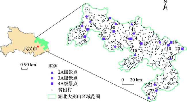
Fig. 1 Distribution map of A-grade scenic spots and poverty villages in Dabie mountain area of Hubei province图1 湖北大别山区A级旅游景点与建档立卡贫困村分布图 |
Tab. 1 Time cost on different grade highways表1 不同等级公路交通时间成本值 |
| 公路等级 | 高速公路 | 国道 | 省道 | 县道 | 其他 |
|---|---|---|---|---|---|
| 速度/(km/h) | 100 | 80 | 60 | 30 | 15 |
| 时间成本/min Cost(A) | 0.6 | 0.75 | 1 | 2 | 4 |
注:表中速度数值来源于《中华人民共和国公路工程技术标准(JT-GB01-2003)》,并根据文献[20]、[24]-[26]做了相应调整 |
Tab. 2 Time cost value of major spatial objects表2 主要空间对象的时间成本设定值 |
| 坡度/° | ||||||
|---|---|---|---|---|---|---|
| 0~5 | 6~15 | 16~25 | 26~35 | 36~45 | >45 | |
| 速度/(km/h) | 5 | 4 | 3 | 2 | 1 | 0.5 |
| 时间成本/min Cost(B坡度) | 0.72 | 0.9 | 1.2 | 1.8 | 3.6 | 7.2 |
| 海拔/m | ≤400 | 401~800 | 801~1200 | 1201~1600 | >1600 | 水域 |
| 速度/(km/h) | 5 | 4 | 3 | 2 | 1 | 0.5 |
| 时间成本/min Cost(B海拔) | 0.72 | 0.9 | 1.2 | 1.8 | 3.6 | 7.2 |
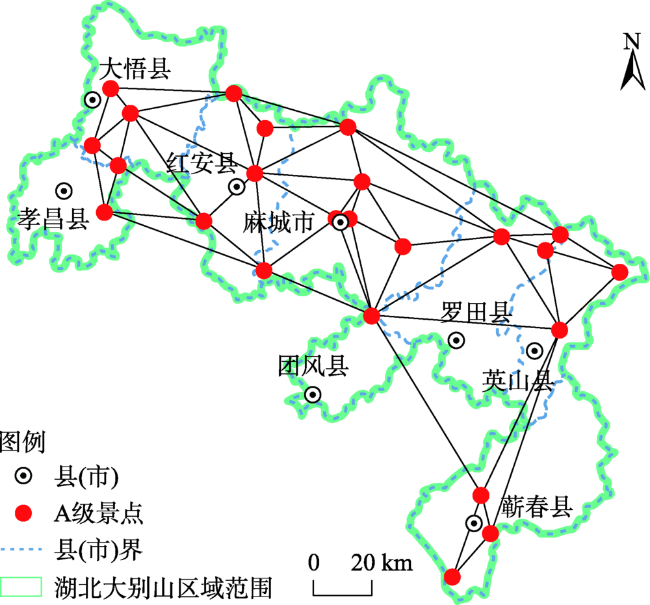
Fig. 2 The spatial structure topology map of A-grade scenic spots图2 A级旅游景点空间结构平面拓扑关系图 |
Tab. 3 The accessibility index of A-grade scenic spots表3 A级旅游景点通达度指数 |
| 旅游节点 | 通达度指数Ai | 旅游节点 | 通达度指数Ai | ||
|---|---|---|---|---|---|
| 数值 | 排序 | 数值 | 排序 | ||
| 五脑山森林公园 | 60.94 | 1 | 大别山主峰旅游风景区 | 86.44 | 13 |
| 麻城市烈士陵园 | 61.12 | 2 | 观音湖旅游度假区 | 88.49 | 14 |
| 麻城市博物馆 | 63.68 | 3 | 天堂寨景区 | 90.15 | 15 |
| 龟峰山景区 | 64.93 | 4 | 徐海东大将亲属烈士陵园 | 90.84 | 16 |
| 黄麻起义和鄂豫皖苏区革命烈士陵园 | 66.30 | 5 | 双峰山旅游度假区 | 91.65 | 17 |
| 杏花村 | 67.23 | 6 | 英山烈士陵园 | 94.08 | 18 |
| 大崎山风景区 | 68.88 | 7 | 新四军五师司令部旧址 | 96.34 | 19 |
| 乘马会馆 | 70.26 | 8 | 鄂豫边区烈士陵园 | 99.17 | 20 |
| 长胜街景区 | 70.43 | 9 | 桃花冲森林公园 | 105.79 | 21 |
| 李先念故居纪念园 | 71.73 | 10 | 三江生态旅游度假区 | 109.38 | 22 |
| 大别山薄刀峰风景区 | 78.26 | 11 | 鄂人谷生态旅游度假村 | 119.51 | 23 |
| 天台山风景区 | 79.03 | 12 | 李时珍纪念馆 | 128.15 | 24 |
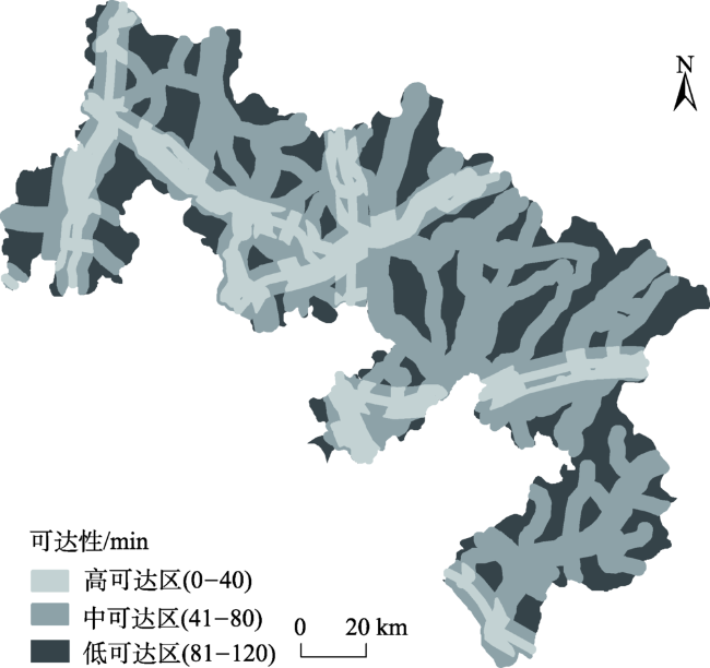
Fig. 3 Accessibility distribution map of scenic spots based on transportation factors图3 研究区旅游景点可达性分布图 |
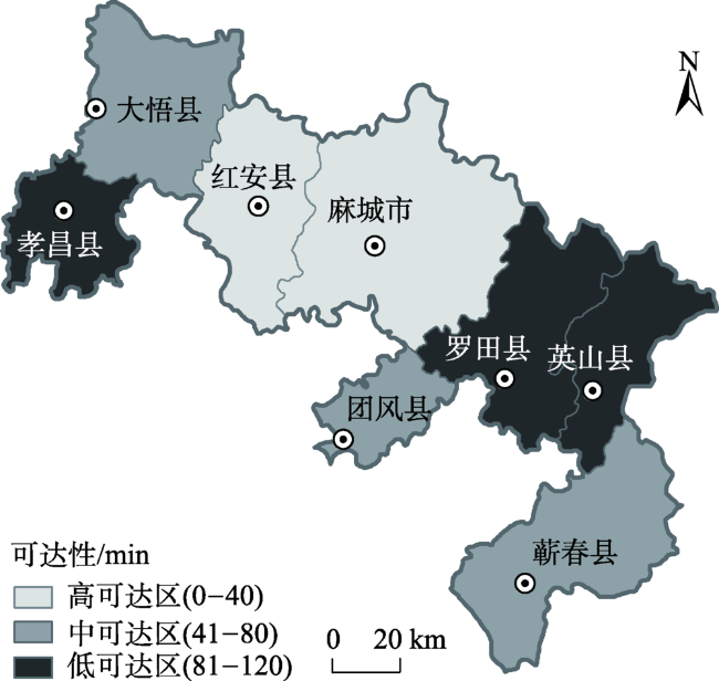
Fig. 4 County administrative map of accessibility based on transportation factors图4 县域单元旅游景点可达性等级图(交通因素) |
Fig. 5 Accessibility distribution map of scenic spots based on terrain factors图5 研究区旅游景点可达性分布图 |
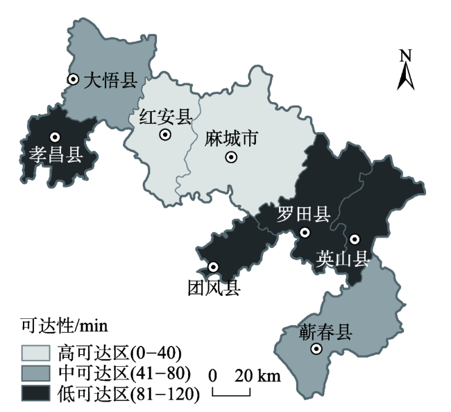
Fig. 6 County administrative map of accessibility based on terrain factors图6 县域单元旅游景点可达性等级图(地形因素) |
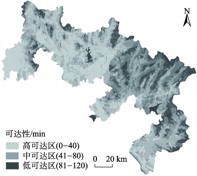
Fig. 7 Accessibility distribution map of scenic spots based on comprehensive factors图7 研究区旅游景点可达性分布图 |
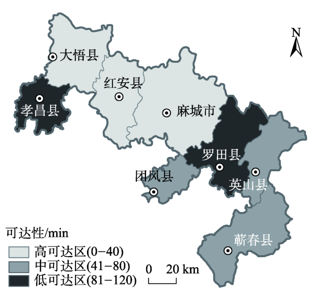
Fig. 8 County administrative map of accessibility based on comprehensive factors图8 县域单元旅游景点可达性等级图(综合因素) |
The authors have declared that no competing interests exist.
| [1] |
|
| [2] |
[
|
| [3] |
|
| [4] |
|
| [5] |
|
| [6] |
|
| [7] |
[
|
| [8] |
[
|
| [9] |
[
|
| [10] |
[
|
| [11] |
[
|
| [12] |
[
|
| [13] |
[
|
| [14] |
[
|
| [15] |
[
|
| [16] |
[
|
| [17] |
[
|
| [18] |
[
|
| [19] |
[
|
| [20] |
[
|
| [21] |
[
|
| [22] |
斯蒂芬·史密斯.旅游决策与分析方法[M].北京:中国旅游出版社,1991.
[
|
| [23] |
[
|
| [24] |
[
|
| [25] |
[
|
| [26] |
[
|
| [27] |
[
|
| [28] |
[
|
/
| 〈 |
|
〉 |