
Journal of Geo-information Science >
Review on Dynamic Monitoring of Mangrove Forestry Using Remote Sensing
Received date: 2018-05-16
Request revised date: 2018-09-14
Online published: 2018-11-20
Supported by
Strategic Priority Research Program of the Chinese Academy of Sciences(A class), No.XDA19060302
Mangrove Resources Remote Sensing Monitoring and Evaluation, No.2017FY100706
China Geological Survey “Belt and Road” Regional Resource and Environment Satellite Remote Sensing Interpretation and Application Funding Project, No.DD20160117.
Copyright
:Mangrove dynamics is one of the hotspots of geography, ecology and wetland science. Remote sensing technology is characterized by macroscopicity, high efficiency and economy, and plays an increasingly important role in the dynamic monitoring of mangroves. This paper searches and summarizes the articles published by Web of Science and China Knowledge Network from 2000 on the basis of keywords, from research area distribution, number of documents, remote sensing data sources and methods, global mangrove dynamics and national red The five aspects of dynamic change analysis of forests summarize the research progress on dynamic monitoring of mangrove remote sensing in the past 20 years. The research results show that multi-sensor high spatial and temporal resolution data will become an important data source for mangrove remote sensing dynamic monitoring. The fusion of radar data and optical remote sensing data will help to further enhance the mangrove satellite remote sensing monitoring capability. The UAV platform is equipped with various types of sensors (such as multi-spectral, hyperspectral or lidar sensors), which can obtain mangrove ecosystem parameters from different aspects. Combined with remote sensing intelligent analysis algorithms, it helps mangrove remote sensing research in the depth direction. development of. The total area of mangrove forests monitored by mangrove remote sensing is roughly 11 million to 24 million hectares , and the overall trend is still decreasing. In the region, the area of mangroves in China has recovered. At the end of this paper, the development trend of mangrove remote sensing dynamic monitoring is prospected.
Key words: mangrove; remote sensing; classification; sensor; dynamic monitoring
ZHOU Zhenchao , LI He , HUANG Chong , LIU Qingsheng , LIU Gaohuan , HE Yun , YU Han . Review on Dynamic Monitoring of Mangrove Forestry Using Remote Sensing[J]. Journal of Geo-information Science, 2018 , 20(11) : 1631 -1643 . DOI: 10.12082/dqxxkx.2018.180247
Fig. 1 Researchers' distribution of remote sensing dynamic monitoring of mangrove in China and Abroad图1 国内外对红树林遥感动态监测的研究者分布 |
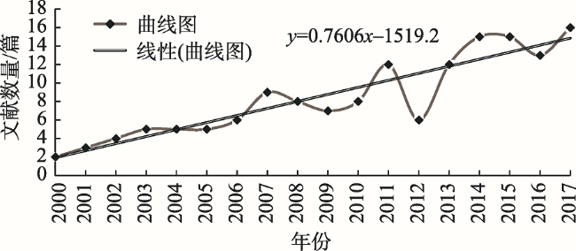
Fig. 2 Number of studies in each year based on Web of Science图2 基于Web of Science的各个年份研究数量 |
Tab. 1 Overview of optical sensors and methods for dynamic monitoring mangrove remote sensing information表1 红树林遥感动态监测运用的光学传感器和方法 |
| 数据源 | 卫星传感器 | 目视解译 | 基于像元的分类法 | 智能化分类方法 | 面向对象 分类法 | 综合 提取法 | ||||
|---|---|---|---|---|---|---|---|---|---|---|
| 波段 组合法 | 像元 分解法 | 专家 决策树 | 人工神经 网络 | 支持 向量机 | 随机 森林 | |||||
| 中分辨率 影像 | Landsat MSS | 6 | 2 | 5 | 1 | 1 | 4 | 3 | ||
| Landsat-5 TM | 8 | 6 | 21 | 5 | 2 | 1 | 1 | 10 | 4 | |
| Landsat-7 ETM+ | 5 | 4 | 12 | 3 | 2 | 1 | 6 | 3 | ||
| Landsat-8 OLI | 5 | 9 | 2 | 4 | 1 | 6 | 2 | |||
| SPOT2-4 | 6 | 1 | 5 | 1 | 2 | |||||
| Sential-2 | 1 | 1 | ||||||||
| THEOS | 1 | 1 | 1 | |||||||
| SPOT5 | 4 | 3 | 3 | 2 | 2 | |||||
| IRS 1C/1D LISS III/IV | 2 | 1 | 1 | 1 | 1 | |||||
| ASTER | 1 | |||||||||
| 高分辨率 影像 | RapidEye | 2 | 1 | 1 | ||||||
| IKONOS | 1 | 4 | 1 | 1 | ||||||
| QuickBird | 5 | 2 | 1 | 1 | ||||||
| Worldview | 3 | 1 | 3 | 1 | 2 | 1 | 1 | |||
| GeoEye | 1 | 5 | 2 | 2 | 2 | |||||
| 航空摄影 | CIR videography/photography | 1 | 1 | 1 | 3 | 2 2 | 1 1 | |||
Tab. 2 Overview of hyperspectral data and methods for extracting mangrove remote sensing information表2 红树林遥感动态监测运用高光谱数据和方法 |
| 数据源 | 卫星传感器 | 目视解译 | 基于像元的分类法 | 智能化分类方法 | 面向对象 分类法 | 综合 提取法 | ||||
|---|---|---|---|---|---|---|---|---|---|---|
| 波段 组合法 | 像元 分解法 | 专家 决策树 | 人工神经 网络 | 支持 向量机 | 随机 森林 | |||||
| 机载 | AISA+ | 2 | 1 | |||||||
| CASI | 1 | 1 | ||||||||
| 星载 | EO-1 Hyperion | 2 | 2 | 3 | 1 | 1 | ||||
Fig. 3 The 10 most mangrove-rich countries from global图3 全球10个红树林面积丰富的国家 |
Tab. 3 Overview of RADAR data and methods for extracting mangrove remote sensing information表3 红树林遥感动态监测运用雷达数据和方法 |
| 数据源 | 卫星传感器 | 目视解译 | 基于像元的分类法 | 智能化分类方法 | 面向对象 分类法 | 综合 提取法 | ||||
|---|---|---|---|---|---|---|---|---|---|---|
| 波段 组合法 | 像元 分解法 | 专家 决策树 | 人工神经 网络 | 支持 向量机 | 随机 森林 | |||||
| 机载 | AIRSAR | 1 | 1 | 1 | 1 | |||||
| ALOS PALSAR | 2 | 5 | 3 | 4 | 1 | |||||
| ALOS AVNIR | 1 | 3 | 3 | 1 | 1 | 1 | ||||
| JERS-1 | 1 | 2 | 1 | 1 | ||||||
| 星载 | Envisat ASAR | 1 | ||||||||
| Radarsat-1 SAR | 1 | 2 | 1 | |||||||
| Sential-1A SAR | 1 | 2 | ||||||||
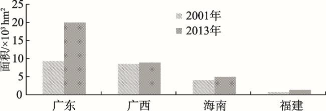
Fig. 4 The Changes of mangrove area in all provincesof the country图4 国家林业局普查中各省份红树林面积对比 |
Tab. 4 The changes of mangrove area in China and application data sources表4 基于不同研究的中国红树林面积对比及运用数据源 |
| 资料出处 | 总面积/ ×104hm2 | 数据源 |
|---|---|---|
| 国家林业局2001年调查 | 2.2025 | Aerial photography |
| 吴培强(2010) | 2.4579 | Landsat TM/ETM+/HJ-1 CCD |
| Jia(2013) | 3.2996 | Landsat MSS/TM/ETM+/OLI |
| 国家林业局2013年调查 | 3.4472 | CBERS-CCD |
Tab. 5 Status of remote sensing monitoring of mangrove forests in each province表5 各省份红树林面积监测研究状况的对比 |
| 省份 | 各个年份红树林的面积/hm2 | 参考文献 | |||||||
|---|---|---|---|---|---|---|---|---|---|
| 2000 | 2001 | 2007 | 2008 | 2010 | 2012 | 2013 | 2014 | ||
| 广西 | 6.679×10³ | 6.448×10³ | 6.758×10³ | [98] | |||||
| 8.781×10³ | [78] | ||||||||
| 7.243×10³ | [99] | ||||||||
| 7.015×10³ | 6.743×10³ | 7.054×10³ | [87] | ||||||
| 1.9714×10⁴ | [78] | ||||||||
| 广东 | 1.0065×10⁴ | 9.5×101 | [9] | ||||||
| 8.722×10³ | 9.9×101 | [5] | |||||||
| 海南 | 4.891×10³ | [79] | |||||||
| 4.736×10³ | [78] | ||||||||
| 3.3×10³ | [88] | ||||||||
| 福建 | 1.184×10³ | [78] | |||||||
| 浙江 | 2×101 | [78] | |||||||
The authors have declared that no competing interests exist.
| [1] |
[
|
| [2] |
[
|
| [3] |
[
|
| [4] |
[
|
| [5] |
[
|
| [6] |
[
|
| [7] |
FAO. Status and trends in mangrove area extent world wide[R]. Rome: Forest resources assessment programme, 2003.
|
| [8] |
[
|
| [9] |
[
|
| [10] |
[
|
| [11] |
[
|
| [12] |
国家林业局森林资源管理司.全国红树林资源报告[R],2002.
[ Forest Resources Management Division, State Forestry Administration. National Mangrove Resources Report [R]. 2002. ]
|
| [13] |
[
|
| [14] |
[
|
| [15] |
[
|
| [16] |
[
|
| [17] |
国家海洋局908专项办公室.海岸带调查技术规程[M].北京:海洋出版社,2012.
[ National Oceanic Administration 908 Special Office. Coastal Zone Survey Technical Regulations[M]. Beijing: Ocean Publishing House, 2012. ]
|
| [18] |
[
|
| [19] |
[
|
| [20] |
[
|
| [21] |
[
|
| [22] |
[
|
| [23] |
[
|
| [24] |
|
| [25] |
[
|
| [26] |
[
|
| [27] |
[
|
| [28] |
[
|
| [29] |
[
|
| [30] |
|
| [31] |
|
| [32] |
[
|
| [33] |
[
|
| [34] |
|
| [35] |
[
|
| [36] |
|
| [37] |
[
|
| [38] |
|
| [39] |
[
|
| [40] |
|
| [41] |
|
| [42] |
|
| [43] |
|
| [44] |
|
| [45] |
|
| [46] |
FAO (Food and Agriculture Organization of the United Nations). The world's mangroves 1980-2005[R]. Rome: 2007: 153-157.
|
| [47] |
FAO (Food and Agriculture Organization of the United Nations)[R]. The State of World Fisheries and Aquaculture. Food and Agriculture Organization, Rome, 2012.
|
| [48] |
|
| [49] |
|
| [50] |
|
| [51] |
|
| [52] |
|
| [53] |
|
| [54] |
|
| [55] |
|
| [56] |
|
| [57] |
|
| [58] |
|
| [59] |
|
| [60] |
|
| [61] |
|
| [62] |
|
| [63] |
|
| [64] |
|
| [65] |
|
| [66] |
|
| [67] |
|
| [68] |
|
| [69] |
|
| [70] |
|
| [71] |
|
| [72] |
|
| [73] |
|
| [74] |
|
| [75] |
|
| [76] |
|
| [77] |
|
| [78] |
|
| [79] |
[
|
| [80] |
[
|
| [81] |
|
| [82] |
|
| [83] |
|
| [84] |
|
| [85] |
|
| [86] |
|
| [87] |
|
| [88] |
|
| [89] |
|
| [90] |
[
|
| [91] |
|
| [92] |
|
| [93] |
|
| [94] |
|
| [95] |
|
| [96] |
|
| [97] |
|
| [98] |
|
| [99] |
|
/
| 〈 |
|
〉 |

