
Journal of Geo-information Science >
Quantifying Spatial Pattern of Built-up Areas in China
Received date: 2018-09-03
Request revised date: 2018-11-26
Online published: 2019-01-30
Supported by
Beijing Nova Program, No.Z181100006218049
Copyright
Accurately quantifying spatial pattern of built-up areas is of great significance to analyzing the ecological and environmental impacts of the built-up landscape and planning for regional development. In this paper, we used the Global Urban Footprint (GUF) data with 12 m spatial resolution in 2012 to analyze the spatial pattern of built-up areas in China at three scales, i.e., the national, economic zone and urban agglomeration scales. Specifically, we chose six landscape metrics, i.e., total area of the built-up area, percentage of the built-up area of the landscape, number of patches, patch density, landscape shape index and mean Euclidean nearest-neighbor distance to measure spatial pattern of the built-up areas. Then, we explored the relationship between spatial pattern of built-up area and socioeconomic variable at different scales. The results showed the 12 m GUF dataset can delineate the built-up area in China with higher accuracy and more details, compared to previous coarse resolution datasets. The built-up areas reached 1.73×10⁵ km2 in 2012, accounting for 1.81% of the total land area in China. At the economic zone scale, more than half of built-up areas concentrated in three economic zones, the Northern Coastal region, the Middle Reaches of the Yellow River and the Eastern Coastal region. From the perspective of the spatial pattern of the built-up areas, the fragmentation of built-up areas was highest at the urban agglomeration scale. The mean patch density at the urban agglomeration scale were 3.66 and 1.62 times as large as those at the national and economic zone scales. The results of correlation analysis indicated that population and economic level played important roles in influencing the spatial pattern of built-up areas. The number of patches and the degree of fragmentation for built-up areas increased with the amount of urban residents, gross domestic product and investment in the fixed assets. The correlation coefficients between these two sets of measurements ranged from 0.55 to 0.94 (P<0.05). In the future, we should make place-based plans to solve the fragmentation of the built-up areas and to promote a rational development of built-up areas in China.
YANG Shuangshuma , HUANG Qingxu , HE Chunyang , LIU Ziwen . Quantifying Spatial Pattern of Built-up Areas in China[J]. Journal of Geo-information Science, 2019 , 21(2) : 178 -189 . DOI: 10.12082/dqxxkx.2019.180438
Tab. 1 The landscape metrics used in this study表1 研究中选取的景观指数 |
| 指数类型 | 指数名称 | 计算公式 | 取值范围 | 含义 |
|---|---|---|---|---|
| 空间组成 | 建设用地面积(CA) /104 km2 | CA>0 | 表征区域中的建设用地斑块面积(aij)的总和 | |
| 建设用地占比(PLAND) /% | 0<PLAND≤100 | 描述了区域中建设用地面积占区域面积(A)的比例 | ||
| 空间配置 | 斑块数量(NP)/个 | NP≥1 | 反映了区域中建设用地斑块的个数(N) | |
| 斑块密度(PD) /(个/km2) | PD>0 | 反映了单位面积上的建设用地斑块数量。其值越高,建设用地斑块越破碎 | ||
| 景观形状指数(LSI) | LSI≥1 | 用来衡量建设用地形状的规则程度。E为建设用地斑块总边长。LSI值越高,建设用地形状越趋向不规则 | ||
| 平均最近邻距离(ENN_MN) /m | ENN_MN>0 | 反映了不同建设用地斑块之间的平均最短欧式距离。hij为区域内每一个建设用地斑块与其最近邻体的距离,为具有邻体的建设用地斑块总数 |
注:表中内容根据Fragstats 4.2用户手册修改[24]。 |
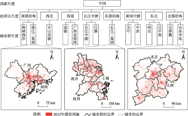
Fig. 1 The herarchy of the built-up areas in China in 2012图1 2012年中国建设用地的等级分布 |
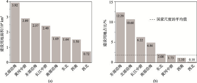
Fig. 2 The comparison of the built-up areas among China's eight economic zones in 2012图2 2012年中国八大经济区的建设用地空间组成 |
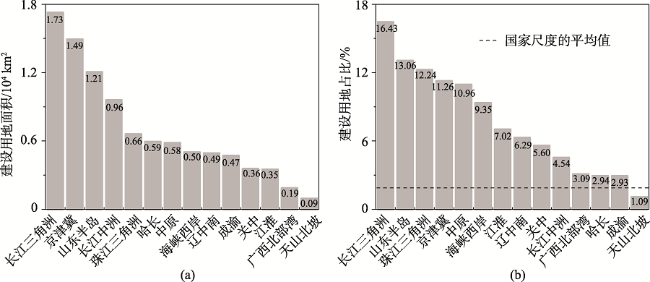
Fig. 3 Construction land area and proportion of 14 urban agglomerations in China in 2012图3 2012年中国14个城市群的建设用地面积及占比 |
Tab. 2 The spatial configuration of the built-up areas in China in 2012表2 2012年中国建设用地的空间配置 |
| 类型 | 斑块数量/106个 | 斑块密度/(个/km2) | 景观形状指数 | 平均最近邻体距离/m |
|---|---|---|---|---|
| 国家尺度 | 6.8 | 0.71 | 3994.25 | 145.87 |
| 经济区尺度均值 | 0.9 | 1.62 | 1417.47 | 156.48 |
| 城市群尺度均值 | 0.2 | 2.46 | 699.48 | 150.22 |
Fig. 4 The spatial configuration of the built-up areas among China's eight economic zones in 2012图4 2012年中国八大经济区的建设用地空间配置 |
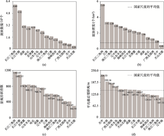
Fig. 5 The spatial configuration of the built-up areas among China's fourteen urban agglomerations in 2012图5 2012年中国14个城市群的建设用地空间配置 |
Tab. 3 Comparison of the built-up areas and urban areas derived from datasets with different spatial resolutions (104 km2)表3 不同空间分辨率数据提取建设用地和城市土地的对比 |
| 尺度 | 12 m分辨率的建设用地面积 | 30 m分辨率的城市土地面积 | 1 km分辨率的城市土地面积 |
|---|---|---|---|
| 国家 | 17.33 | 9.08 | 6.48 |
| 经济区 | 2.20 | 1.14 | 0.81 |
| 城市群 | 0.69 | 0.22 | 0.32 |
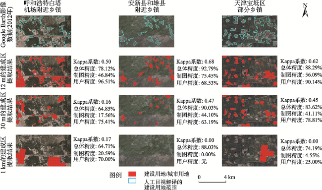
Fig. 6 Extraction of small-scale and rural built-up areas from three datasets with difference spatial resolutions图6 不同空间分辨率数据对小规模和农村建设用地的提取对比 |
Tab. 4 Comparison of the spatial patterns of the built-up area based on the different spatial resolution data表4 不同空间分辨率数据提取的建设用地空间格局对比 |
| 空间组成 | 空间配置 | ||||||
|---|---|---|---|---|---|---|---|
| 建设用地 面积/ km2 | 建设用地 占比/% | 斑块 数量/个 | 斑块密度 /(个/km2) | 景观形状 指数 | 平均最近 邻距离/m | ||
| 呼和浩特白塔 机场附近乡镇 | 目视解译结果 | 21.51 | 23.40 | 33 | 0.36 | 10.59 | 187.14 |
| 12 m空间分辨率 | 13.38 | 19.36 | 156 | 1.90 | 26.95 | 71.78 | |
| 30 m空间分辨率 | 11.23 | 9.29 | 26 | 0.32 | 6.28 | 576.18 | |
| 1 km空间分辨率 | 4.00 | 11.76 | 3 | 0.04 | 1.71 | 4070.37 | |
| 安新县和雄县 附近乡镇 | 目视解译结果 | 14.48 | 9.69 | 22 | 0.15 | 9.19 | 472.65 |
| 12 m空间分辨率 | 15.53 | 13.41 | 302 | 2.61 | 29.23 | 63.49 | |
| 30 m空间分辨率 | 9.88 | 8.53 | 28 | 0.24 | 6.77 | 524.46 | |
| 1 km空间分辨率 | - | - | - | - | - | - | |
| 天津宝坁区 部分乡镇 | 目视解译结果 | 32.75 | 39.89 | 9 | 0.11 | 7.04 | 251.95 |
| 12 m空间分辨率 | 15.89 | 14.56 | 226 | 2.46 | 23.98 | 82.12 | |
| 30 m空间分辨率 | 7.63 | 12.22 | 41 | 0.45 | 8.90 | 299.85 | |
| 1 km空间分辨率 | 10.00 | 4.30 | 1 | 0.01 | 10.59 | - | |
Tab. 5 The relationship between the spatial pattern of built-up areas and socio-economic factors at the urban agglomeration scale表5 城市群尺度社会经济要素与建设用地空间格局的关系 |
| 空间组成 | 空间配置 | ||||||
|---|---|---|---|---|---|---|---|
| 建设用地 面积/104km2 | 建设用地 占比/% | 斑块 数量/个 | 斑块密度 /(个/km2) | 景观形状 指数 | 平均最近 邻距离/m | ||
| 人口 指标 | 总人口/万人 | 0.78** | 0.42 | 0.89** | 0.55** | 0.88** | -0.30 |
| 城市人口/万人 | 0.76** | 0.57** | 0.83** | 0.70** | 0.77** | -0.31 | |
| 城镇化率/% | -0.14 | 0.14 | -0.25 | 0.03 | -0.37 | 0.21 | |
| 经济 指标 | 国内生产总值/亿元 | 0.91** | 0.71** | 0.85** | 0.79** | 0.84** | -0.46* |
| 第二产业生产总值/亿元 | 0.90** | 0.70** | 0.89** | 0.81** | 0.87** | -0.46* | |
| 第三产业生产总值/亿元 | 0.90** | 0.75** | 0.77** | 0.77** | 0.74** | -0.45 | |
| 固定资产投资金额(不含农户)/亿元 | 0.90** | 0.55** | 0.94** | 0.71** | 0.95** | -0.40 | |
注:*表示相关系数在0.10水平显著(双尾检验),**表示相关系数在0.05水平显著(双尾检验)。 |
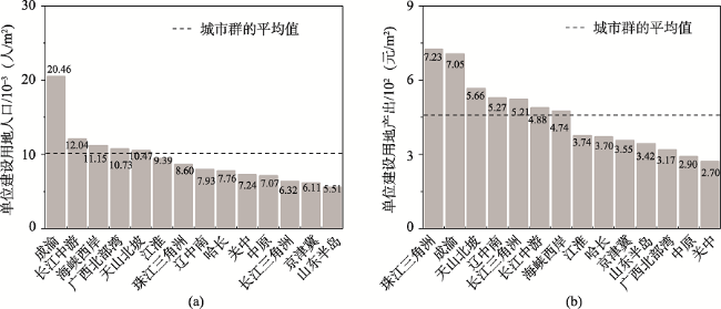
Fig. 7 The intensification of the built-up land among urban agglomerations in China in 2012图7 2012年中国城市群建设用地的集约化水平 |
Tab. 6 Logistic regression results of the built-up areas in China in 2012表6 2012年中国建设用地Logistics回归结果 |
| 变量 | 回归系数 | 标准差 | 显著水平 | 让步比exp(β) | ROC |
|---|---|---|---|---|---|
| 高程 | -6.59 | 0.06 | 0.00 | 1.40×10⁻³ | 0.92 |
| 坡度 | -19.71 | 0.13 | 0.00 | 2.77×10⁻⁹ | |
| 距河流的距离 | 0.63 | 0.45 | 0.16 | 1.87 | |
| 多年平均气温 | 0.33 | 0.02 | 0.00 | 1.39 | |
| 多年平均降水 | -0.50 | 0.02 | 0.00 | 0.61 | |
| 距一般公路的距离 | -12.89 | 0.28 | 0.00 | 3.00×10⁻⁶ | |
| 距铁路的距离 | -1.49 | 0.06 | 0.00 | 0.22 | |
| 距市中心的距离 | -18.97 | 0.16 | 0.00 | 5.79×10⁻⁹ | |
| 距县中心的距离 | -102.87 | 0.50 | 0.00 | 2.11×10-45 | |
| 常数 | -0.28 | 0.01 | 0.00 | 0.76 |
The authors have declared that no competing interests exist.
| [1] |
|
| [2] |
|
| [3] |
国家统计局.中国统计年鉴-2017[M].北京:中国统计出版社,2017.
[ National Bureau of Statistics of China 2017 China Statistical Yearbook[M] China 2017 China Statistical Yearbook[M]. Beijing: China Statistics Press, 2017. ]
|
| [4] |
|
| [5] |
|
| [6] |
[
|
| [7] |
[
|
| [8] |
[
|
| [9] |
|
| [10] |
|
| [11] |
|
| [12] |
|
| [13] |
|
| [14] |
|
| [15] |
|
| [16] |
|
| [17] |
|
| [18] |
[
|
| [19] |
[
|
| [20] |
|
| [21] |
[
|
| [22] |
[
|
| [23] |
|
| [24] |
|
| [25] |
中共中央国务院.国家新型城镇化规划(2014-2020年)[R].北京:新华社,2014.
[ The CPC Central Committee TSC. National New-type Urbanization Plan (2014-2020)[R]. Beijing: Xinhua News Agency, 2014. ]
|
| [26] |
|
| [27] |
国务院.中华人民共和国国民经济和社会发展第十三个五年 (2016-2020年) 规划纲要[R].北京,2016-03-17.
[ The State Council of PRC. The 13th Five-Year Plan for Economic and Social Development of the People’s Republic of China (2016-2020) [R]. Beijing, 2016-03-17. ]
|
| [28] |
[
|
| [29] |
|
| [30] |
|
| [31] |
[
|
| [32] |
|
| [33] |
|
| [34] |
[
|
| [35] |
|
| [36] |
[
|
| [37] |
|
| [38] |
|
| [39] |
[
|
| [40] |
[
|
| [41] |
[
|
/
| 〈 |
|
〉 |
