
Journal of Geo-information Science >
Extraction of Summer Crop in Jiangsu based on Google Earth Engine
Received date: 2018-08-29
Request revised date: 2019-01-11
Online published: 2019-05-25
Supported by
National Key R&D Program of China, No.2016YFD0300608
Science and Technology Service Network Initiative (STS), No.KFJ-STS-ZDTP-009
National Natural Science Foundation of China, No. 41561144013, 41861144019, 41701496.
Copyright
Jiangsu province, with 13 municipalities and located in the east of China, is an important part of the Yangtze river delta economy belt. The temperature is appropriate and the rainfall is moderate. Jiangsu province enjoys a moderate climate, which is suitable for the agricultural development. Winter wheat is distributed throughout the whole province, whereas the planting structure of winter rapeseed is complex and mainly scattered in Southern Jiangsu. As reported by the State Statistics Bureau, the total planting area of winter wheat and winter rapeseed in Jiangsu ranked the fifth and seventh in China, respectively, during the last 10 years. Fast obtaining the precise planting area of these two crops in Jiangsu is crucial for the agricultural development. Remote sensing classification based on local host can obtain spatial distribution of crops with high accuracy, but is time-consuming. With the development of geographical big data, cloud platform, and cloud computation, the Google Earth Engine (GEE), a global scale geospatial analysis platform based on the cloud platform, has brought new opportunities for rapid remote sensing classification. Based on the GEE cloud platform, a time-saving method of obtaining the spatial distribution of winter wheat and winter rapeseed by use of sentinel-2 data in Jiangsu was proposed. First, 119 sentinel-2 images without cloud were obtained using the GEE in Jiangsu. The time interval was set from March 1 to June 1, 2017, and the space area was Jiangsu province. Based on the spatio-temporal information, the 119 remote sensing images were mosaicked and clipped. Secondly, remote sensing indices, texture, and terrain features were calculated respectively, and the original features were extracted. The original feature space was optimized by an algorithm named Separability and Thresholds (SEaTH algorithm). Finally, four classifiers including naive Bayes, support vector machine, classification regression tree, and random forest were tested and evaluated by the average assessment accuracy. The spatial distribution information of winter wheat and winter rapeseed were obtained quickly. The following conclusions are drawn: (1) the GEE can quickly complete pre-processing of cloud-masking, image-mosaicking, image-clipping, and feature extraction, which is superior to the local processing. (2) The distance values of J-M that are higher than 1 and rank top two highest can reduce the number of features from 28 to 11 and effectively compress the original feature space. (3) With the combined training of spectral, texture and terrain features, the average assessment accuracy of naive Bayes, support vector machine, classification regression tree, and random forest was 61%, 87%, 89% and 92%, respectively.
HE Zhaoxin , ZHANG Miao , WU Bingfang , XING Qiang . Extraction of Summer Crop in Jiangsu based on Google Earth Engine[J]. Journal of Geo-information Science, 2019 , 21(5) : 752 -766 . DOI: 10.12082/dqxxkx.2019.180420
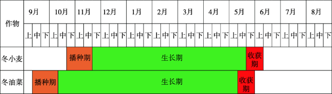
Fig. 1 The phenology calendar of winter wheat and winter rape in Jiangsu province图1 江苏省冬小麦、冬油菜物候历 |
Tab. 1 The waveband parameters of Sentinel-2表1 Sentinel-2波段参数 |
| 序号 | 波段名称 | 中心波长/nm | 空间分辨率/m | 属性 |
|---|---|---|---|---|
| 01 | B1 | 443 | 60 | 气溶胶 |
| 02 | B2 | 490 | 10 | 蓝 |
| 03 | B3 | 560 | 10 | 绿 |
| 04 | B4 | 665 | 10 | 红 |
| 05 | B5 | 705 | 20 | 红边1 |
| 06 | B6 | 740 | 20 | 红边2 |
| 07 | B7 | 783 | 20 | 红边3 |
| 08 | B8 | 842 | 10 | 近红外 |
| 09 | B8A | 865 | 20 | 红边4 |
| 10 | B9 | 940 | 60 | 水蒸气 |
| 11 | B10 | 1375 | 60 | 卷云 |
| 12 | B11 | 1610 | 20 | 短波红外1 |
| 13 | B12 | 2190 | 20 | 短波红外2 |
| 14 | QA10 | 10 | ||
| 15 | QA20 | 20 | ||
| 16 | QA60 | 60 | 云掩膜 |
Tab. 2 Sample data表2 样本数据 |
| 地类代码 | 地类名称 | 样本数量/个 |
|---|---|---|
| 0 | 冬小麦 | 615 |
| 1 | 冬油菜 | 546 |
| 2 | 其他植被 | 610 |
| 3 | 水体 | 653 |
| 4 | 人工地表 | 666 |
| 总计 | 3090 |
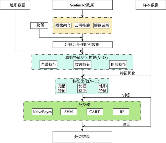
Fig. 2 Technical flowchart of remote sensing extraction for summer crops图2 夏收作物遥感提取技术流程 |
Tab. 3 J-m distance表3 J-M距离 |
| 0-1 | 0-2 | 0-3 | 0-4 | 1-2 | 1-3 | 1-4 | 2-3 | 2-4 | 3-4 | |
|---|---|---|---|---|---|---|---|---|---|---|
| B1 | 0.2680 | 0.1899 | 0.3451 | 0.8664 | 0.3541 | 0.2860 | 0.9974 | 0.0699 | 0.4645 | 0.5532 |
| B10 | 0.1086 | 0.0510 | 0.2655 | 0.4685 | 0.2786 | 0.2367 | 0.7439 | 0.4025 | 0.3023 | 0.6612 |
| B11 | 0.0345 | 0.2059 | 1.7859 | 0.8597 | 0.3667 | 1.7725 | 0.9742 | 1.7906 | 0.5136 | 1.5788 |
| B12 | 0.0986 | 0.1134 | 0.9006 | 1.0067 | 0.3045 | 1.1916 | 1.2127 | 1.2405 | 0.8051 | 1.4930 |
| B2 | 0.4440 | 0.1323 | 0.4348 | 1.0042 | 0.4218 | 0.4415 | 1.1720 | 0.1188 | 0.7053 | 0.6220 |
| B3 | 0.5995 | 0.1026 | 0.2994 | 0.8887 | 0.2938 | 0.1648 | 0.7916 | 0.0623 | 0.6161 | 0.4861 |
| B4 | 0.1689 | 0.0809 | 0.1894 | 1.1174 | 0.0806 | 0.0721 | 1.0340 | 0.0265 | 0.8892 | 0.8105 |
| B5 | 0.8843 | 0.1368 | 0.0526 | 0.8874 | 0.4293 | 1.1382 | 0.8545 | 0.2567 | 0.5771 | 0.9491 |
| B6 | 0.3152 | 0.2685 | 1.9948 | 0.4921 | 0.5103 | 1.9985 | 0.6967 | 1.6821 | 0.0608 | 1.3003 |
| B7 | 0.0068 | 0.4568 | 1.9962 | 0.8542 | 0.4653 | 1.9980 | 0.8656 | 1.6988 | 0.1047 | 1.3183 |
| B8 | 0.0303 | 0.3785 | 1.9981 | 0.8838 | 0.5434 | 1.9999 | 1.0667 | 1.7931 | 0.1511 | 1.4576 |
| B8A | 0.0126 | 0.4349 | 1.9984 | 0.9105 | 0.4010 | 1.9989 | 0.8751 | 1.8037 | 0.1397 | 1.4569 |
| B9 | 0.4272 | 0.6179 | 1.9324 | 0.6222 | 0.0246 | 1.5326 | 0.0662 | 1.3821 | 0.0265 | 1.1396 |
| EVI | 0.0890 | 0.4287 | 1.9808 | 1.9302 | 0.4344 | 1.9970 | 1.9851 | 1.8262 | 1.5374 | 0.8268 |
| LSWI | 0.0513 | 0.4662 | 0.0249 | 1.7987 | 0.7753 | 0.1316 | 1.9234 | 0.3106 | 1.2424 | 1.6268 |
| NDBI | 0.0513 | 0.4662 | 0.0249 | 1.7987 | 0.7753 | 0.1316 | 1.9234 | 0.3106 | 1.2424 | 1.6268 |
| NDVI | 0.1701 | 0.2972 | 1.9492 | 1.9432 | 0.3385 | 1.9726 | 1.9892 | 1.7693 | 1.6042 | 0.8157 |
| NDWI | 0.3376 | 0.4312 | 1.9838 | 1.6811 | 0.4369 | 1.9919 | 1.7671 | 1.9134 | 1.0092 | 1.4172 |
| B8_asm | 0.0750 | 0.0302 | 1.4439 | 0.0103 | 0.1730 | 1.5201 | 0.1250 | 1.3745 | 0.0055 | 1.4037 |
| B8_contrast | 0.8985 | 0.3195 | 0.2373 | 0.5606 | 0.3501 | 0.4561 | 0.1051 | 0.0777 | 0.1247 | 0.1443 |
| B8_corr | 0.1056 | 0.0312 | 0.1653 | 0.0426 | 0.1877 | 0.3961 | 0.2288 | 0.0639 | 0.0040 | 0.0458 |
| B8_ent | 0.0552 | 0.0296 | 1.1539 | 0.0099 | 0.1488 | 1.2592 | 0.1035 | 1.0524 | 0.0054 | 1.0964 |
| B8_idm | 0.1398 | 0.0183 | 1.0954 | 0.0127 | 0.1780 | 1.2619 | 0.1310 | 1.0107 | 0.0045 | 1.0511 |
| B8_var | 0.8535 | 0.3683 | 0.3689 | 0.6562 | 0.2288 | 0.2918 | 0.0621 | 0.0559 | 0.1381 | 0.1123 |
| aspect | 0.0047 | 0.0084 | 0.1336 | 0.0136 | 0.0142 | 0.1159 | 0.0316 | 0.2022 | 0.0317 | 0.1383 |
| elevation | 0.1988 | 0.7377 | 0.0249 | 0.0298 | 1.0175 | 0.2476 | 0.3239 | 0.6190 | 0.5991 | 0.0141 |
| hillshade | 0.0098 | 0.4100 | 0.0847 | 0.1292 | 0.4665 | 0.1360 | 0.1714 | 0.1881 | 0.1197 | 0.0228 |
| slope | 0.0095 | 0.8064 | 0.3598 | 0.1896 | 0.8690 | 0.4255 | 0.2569 | 0.2386 | 0.4186 | 0.0585 |
注:0:冬小麦;1:冬油菜;2:其他植被;3:水体;4:人工地表。 |
Tab. 4 Original features space and optimization表4 原始特征空间与优化 |
| 特征种类 | 原始特征 | 数量/个 | 优化后特征 | 数量/个 |
|---|---|---|---|---|
| 光谱特征 | B1、B2、B3、B4、B5、B6、B7、B8、B8A、B9、B10、B11、B12、EVI、LSWI、NDBI、NDVI、NDWI | 18 | B8、B8A、EVI、LSWI、NDBI、NDVI、NDWI | 7 |
| 纹理特征 | B8_asm、B8_contrast、B8_corr、B8_var、B8_idm、B8_ent | 6 | B8_asm、B8_idm、B8_ent | 3 |
| 地形特征 | elevation、slope、aspect、hillshade | 4 | elevation | 1 |
| 总计 | 28 | 11 |
Tab. 5 Parameters of classifiers表5 分类器参数 |
| 分类器 | 参数 |
|---|---|
| 朴素贝叶斯 | Lambda:0.000 000 1 |
| 支持向量机 | kernelType:RBF; gamma:0.5; cost:50 |
| 分类回归树 | crossvalidationFactor:10; maxDepth:10 |
| 随机森林 | NumberOfTrees:200; variablesPerSplit:0 |
Tab. 6 Average verification precisions of different combinations of features and classifiers表6 不同特征、不同分类器组合的平均验证精度分布 |
| 分类器 | 特征 | |||||||
|---|---|---|---|---|---|---|---|---|
| 光谱 | 纹理 | 地形 | 光谱+纹理 | 光谱+地形 | 纹理+地形 | 光谱+纹理+地形 | ||
| 朴素贝叶斯 | 0 | 0.49 | 0.37 | 0.21 | 0.49 | 0.59 | 0.29 | 0.59 |
| 1 | 0.50 | 0.21 | 0.21 | 0.50 | 0.60 | 0.21 | 0.60 | |
| 2 | 0.51 | 0.21 | 0.21 | 0.51 | 0.61 | 0.21 | 0.65 | |
| 3 | 0.51 | 0.20 | 0.20 | 0.51 | 0.60 | 0.20 | 0.60 | |
| 4 | 0.49 | 0.21 | 0.21 | 0.49 | 0.60 | 0.21 | 0.60 | |
| 5 | 0.49 | 0.21 | 0.21 | 0.49 | 0.59 | 0.21 | 0.65 | |
| 6 | 0.51 | 0.21 | 0.21 | 0.51 | 0.60 | 0.21 | 0.61 | |
| 7 | 0.49 | 0.21 | 0.21 | 0.49 | 0.58 | 0.21 | 0.60 | |
| 8 | 0.50 | 0.19 | 0.19 | 0.50 | 0.61 | 0.19 | 0.61 | |
| 9 | 0.50 | 0.20 | 0.20 | 0.50 | 0.58 | 0.20 | 0.58 | |
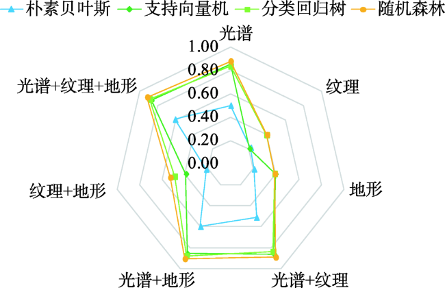
| 均值 | 0.50 | 0.22 | 0.21 | 0.51 | 0.60 | 0.21 | 0.61 | |
| 支持向量机 | 0 | 0.85 | 0.23 | 0.38 | 0.86 | 0.85 | 0.38 | 0.86 |
| 1 | 0.87 | 0.21 | 0.38 | 0.87 | 0.84 | 0.37 | 0.87 | |
| 2 | 0.86 | 0.21 | 0.40 | 0.88 | 0.88 | 0.41 | 0.88 | |
| 3 | 0.85 | 0.20 | 0.42 | 0.85 | 0.86 | 0.41 | 0.86 | |
| 4 | 0.84 | 0.21 | 0.41 | 0.86 | 0.85 | 0.41 | 0.86 | |
| 5 | 0.85 | 0.21 | 0.40 | 0.87 | 0.86 | 0.38 | 0.89 | |
| 6 | 0.86 | 0.21 | 0.40 | 0.88 | 0.85 | 0.38 | 0.89 | |
| 7 | 0.85 | 0.21 | 0.38 | 0.84 | 0.84 | 0.40 | 0.86 | |
| 8 | 0.85 | 0.19 | 0.38 | 0.85 | 0.87 | 0.37 | 0.84 | |
| 9 | 0.86 | 0.20 | 0.40 | 0.88 | 0.85 | 0.40 | 0.88 | |
| 均值 | 0.85 | 0.21 | 0.39 | 0.86 | 0.86 | 0.39 | 0.87 | |
| 分类回归树 | 0 | 0.82 | 0.39 | 0.38 | 0.82 | 0.89 | 0.47 | 0.89 |
| 1 | 0.84 | 0.40 | 0.37 | 0.84 | 0.86 | 0.49 | 0.88 | |
| 2 | 0.86 | 0.41 | 0.39 | 0.85 | 0.90 | 0.48 | 0.91 | |
| 3 | 0.82 | 0.40 | 0.40 | 0.82 | 0.88 | 0.51 | 0.91 | |
| 4 | 0.84 | 0.41 | 0.39 | 0.83 | 0.88 | 0.51 | 0.89 | |
| 5 | 0.84 | 0.39 | 0.40 | 0.86 | 0.88 | 0.48 | 0.90 | |
| 分类器 | 特征 | |||||||
| 光谱 | 纹理 | 地形 | 光谱+纹理 | 光谱+地形 | 纹理+地形 | 光谱+纹理+地形 | ||
| 分类回归树 | 6 | 0.84 | 0.39 | 0.38 | 0.84 | 0.86 | 0.49 | 0.86 |
| 7 | 0.83 | 0.39 | 0.37 | 0.84 | 0.88 | 0.49 | 0.89 | |
| 8 | 0.82 | 0.37 | 0.38 | 0.82 | 0.87 | 0.50 | 0.87 | |
| 9 | 0.84 | 0.41 | 0.40 | 0.85 | 0.87 | 0.50 | 0.88 | |
| 均值 | 0.83 | 0.40 | 0.39 | 0.84 | 0.88 | 0.49 | 0.89 | |
| 随机森林 | 0 | 0.87 | 0.39 | 0.37 | 0.87 | 0.90 | 0.51 | 0.90 |
| 1 | 0.88 | 0.40 | 0.38 | 0.89 | 0.91 | 0.55 | 0.92 | |
| 2 | 0.89 | 0.39 | 0.40 | 0.89 | 0.93 | 0.54 | 0.93 | |
| 3 | 0.88 | 0.39 | 0.39 | 0.89 | 0.90 | 0.52 | 0.91 | |
| 4 | 0.88 | 0.41 | 0.39 | 0.88 | 0.89 | 0.54 | 0.90 | |
| 5 | 0.90 | 0.43 | 0.38 | 0.90 | 0.91 | 0.53 | 0.92 | |
| 6 | 0.87 | 0.41 | 0.37 | 0.88 | 0.90 | 0.52 | 0.91 | |
| 7 | 0.88 | 0.39 | 0.46 | 0.88 | 0.91 | 0.55 | 0.92 | |
| 8 | 0.86 | 0.41 | 0.37 | 0.88 | 0.89 | 0.54 | 0.92 | |
| 9 | 0.88 | 0.37 | 0.38 | 0.88 | 0.90 | 0.52 | 0.91 | |
| 均值 | 0.88 | 0.40 | 0.39 | 0.89 | 0.90 | 0.53 | 0.92 | |
Fig. 3 Average verification precision radar distribution map with different combinations of features and classifiers图3 不同特征、分类器组合的平均验证精度雷达分布 |
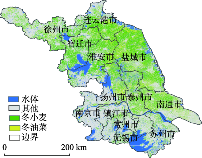
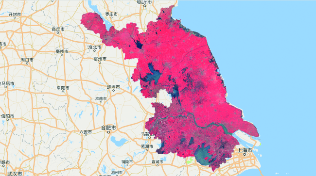
Fig. 4 Spatial distribution of winter wheat and winter rape in Jiangsu province in 2017图4 2017年江苏省冬小麦和冬油菜空间分布 |
Tab. 7 Precision evaluation confusion matrix of Random Forest algorithm表7 随机森林算法精度评价混淆矩阵 |
| 混淆矩阵 | 真实类别 | |||||||
|---|---|---|---|---|---|---|---|---|
| 冬小麦 | 冬油菜 | 其他植被 | 水体 | 人工地表 | 总计 | 用户精度 | ||
| 预测类别 | 冬小麦 | 155 | 7 | 2 | 0 | 1 | 165 | 0.94 |
| 冬油菜 | 10 | 160 | 2 | 0 | 0 | 172 | 0.93 | |
| 其他植被 | 18 | 3 | 168 | 0 | 1 | 190 | 0.88 | |
| 水体 | 2 | 0 | 0 | 203 | 4 | 209 | 0.97 | |
| 人工地表 | 2 | 1 | 8 | 1 | 192 | 204 | 0.94 | |
| 总计 | 187 | 171 | 180 | 204 | 198 | 940 | ||
| 制图精度 | 0.83 | 0.94 | 0.93 | 1.00 | 0.97 | |||
| 总体精度 | 0.93 | |||||||
| Kappa系数 | 0.92 | |||||||
Fig. 5 The GEE image processing for Jiangsu图5 江苏GEE影像处理 |
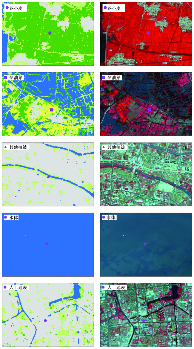
Fig. 6 Random forest classification results of Sentinel-2 image compared with the original image图6 Sentinel-2影像随机森林分类结果(左图)与原始影像(右图)的对比 |
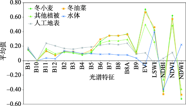
Fig. 7 Spectral feature graph of different classes图7 不同类别的光谱特征曲线 |
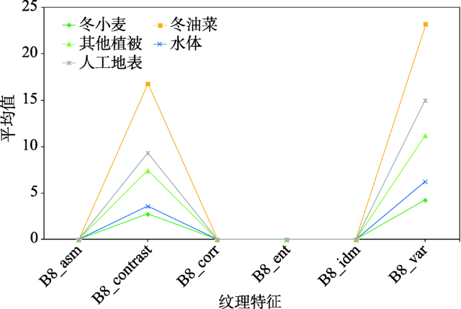
Fig. 8 Texture feature graph of different classes图8 不同类别的纹理特征曲线 |
Fig. 9 Topographic feature graph of different classes图9 不同类别的地形特征曲线 |
Fig. 10 Average altitude of different classes图10 不同类别的平均海拔高度 |
The authors have declared that no competing interests exist.
| [1] |
国家统计局.分省年度数据,2008-2017[EB/OL]..
[ State Statistics Bureau. Provincial annual data, 2008-2017[EB/OL]. . ]
|
| [2] |
[
|
| [3] |
[
|
| [4] |
[
|
| [5] |
[
|
| [6] |
[
|
| [7] |
[
|
| [8] |
[
|
| [9] |
|
| [10] |
|
| [11] |
[
|
| [12] |
|
| [13] |
[
|
| [14] |
|
| [15] |
[
|
| [16] |
|
| [17] |
[
|
| [18] |
|
| [19] |
|
| [20] |
[
|
| [21] |
[
|
| [22] |
[
|
| [23] |
|
| [24] |
[
|
| [25] |
[
|
| [26] |
[
|
| [27] |
[
|
| [28] |
|
| [29] |
|
| [30] |
[
|
| [31] |
|
| [32] |
|
| [33] |
|
| [34] |
|
| [35] |
|
| [36] |
|
| [37] |
|
| [38] |
|
| [39] |
|
| [40] |
[
|
| [41] |
|
| [42] |
[
|
| [43] |
|
| [44] |
|
| [45] |
[
|
| [46] |
[
|
| [47] |
[
|
/
| 〈 |
|
〉 |