
Journal of Geo-information Science >
Surface Subsidence Monitoring during the Construction of Nanning Subways
Received date: 2019-04-03
Request revised date: 2019-07-01
Online published: 2019-09-24
Supported by
National Natural Science Foundation of China(41661090)
National Natural Science Foundation of China(41661021)
Guangxi Natural Science Fund Innovation Team Project(2016JJF15001)
Nanning Normal University School-level Scientific Research Launch Project(0819-2017L05)
Copyright
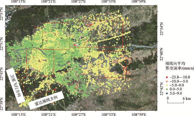
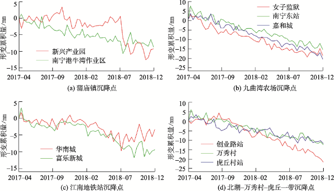
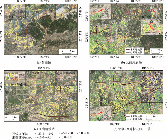
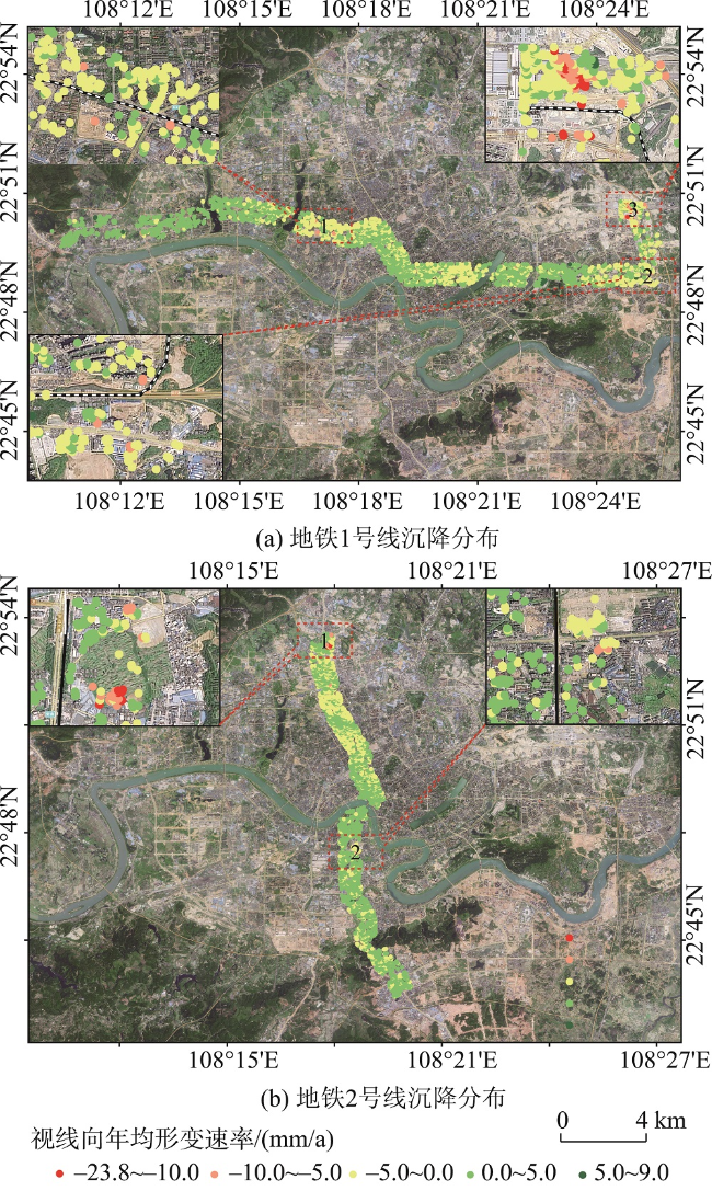
Nanning is the core city of the Beibu Gulf Economic Zone and the permanent venue of the China-ASEAN Expo, which is undergoing the construction peak of urban subways. Nanning is located in the central and western part of the Nanning Basin, where the geological and hydrological conditions are complicated. The construction and operation of subways may cause potential risks such as surface subsidence. However, it remains understudied regarding the surface subsidence along Nanning subways. In this paper, 54 Sentinel-1A images of Nanning city from April 2017 to December 2018 were processed by Permanent Scatterers Interferometric Synthetic Aperture Radar (PS-InSAR), and then the surface subsidence information was extracted. Results showed that the surface deformation rate was -23.8~9.0 mm/a during the monitoring period, and most of the study area was stable, and the settlement point distribution was sporadic. There were four key subsidence areas , including Pumiao Town, Jiuquwan Farm, Jiangnan Subway Station, and Beihu- Wanxiu Village- Huqiu. The deformation curve of key settlement areas showed an uneven decline trend with time; the reason causing settlement may be attributed to the expansion characteristics of expansive soil, spoil landslide, construction operation, excessive train flow, and drop in the groundwater level. The sedimentation value of the five subways were all within the safe range. The rainy season precipitation of Nanning is rich, and the topsoil of the subway construction area is mainly composed of loose Quaternary overburden, where the underlying bedrock is mainly composed of Tertiary expansive soil with certain instability of engineering mechanics. Therefore, our findings suggest that the PS-InSAR technology should be used for long-term monitoring of key settlement areas and subways of Nanning for safe metro operation.
Key words: Subway; Sentinel-1A; PS-InSAR; surface subsidence; tertiary expansive soil; nanning
QIN Wen , HUANG Qiuyan , YU Lu , HU Baoqing . Surface Subsidence Monitoring during the Construction of Nanning Subways[J]. Journal of Geo-information Science, 2019 , 21(9) : 1467 -1478 . DOI: 10.12082/dqxxkx.2019.190151
Tab. 1 Nanning subways construction schedule |
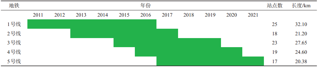 |
表2 Sentinel-1A卫星数据参数信息Tab.2 Parameters of the Sentinel-1A satellite data |
| 时间 | 时间基线/d | 空间基线/m | 时间 | 时间基线/d | 空间基线/m | 时间 | 时间基线/d | 空间基线/m | |
|---|---|---|---|---|---|---|---|---|---|
| 2017-04-03 | 0 | -35.0929 | 2017-11-05 | 216 | 45.2097 | 2018-06-09 | 432 | -24.6097 | |
| 2017-04-15 | 12 | -74.4984 | 2017-11-17 | 228 | 41.5198 | 2018-06-21 | 444 | -1.7339 | |
| 2017-04-27 | 24 | 70.6223 | 2017-11-29 | 240 | 15.9682 | 2018-07-03 | 456 | 73.8204 | |
| 2017-05-09 | 36 | -75.0670 | 2017-12-11 | 252 | 33.7829 | 2018-07-15 | 468 | 35.5915 | |
| 2017-05-21 | 48 | -43.8730 | 2017-12-23 | 264 | 82.5005 | 2018-07-27 | 480 | 47.1928 | |
| 2017-06-02 | 60 | -30.8616 | 2018-01-04 | 276 | 82.5183 | 2018-08-08 | 492 | 20.8403 | |
| 2017-06-14 | 72 | 10.9047 | 2018-01-16 | 288 | 46.8289 | 2018-08-20 | 504 | -36.5445 | |
| 2017-06-26 | 84 | 20.1468 | 2018-01-28 | 300 | 50.1835 | 2018-09-01 | 516 | -73.3495 | |
| 2017-07-08 | 96 | 67.6315 | 2018-02-09 | 312 | -20.2486 | 2018-09-13 | 528 | 29.7106 | |
| 2017-07-20 | 108 | 36.1572 | 2018-02-21 | 324 | -5.6931 | 2018-09-25 | 540 | 62.7836 | |
| 2017-08-01 | 120 | -50.6033 | 2018-03-05 | 336 | 0 | 2018-10-07 | 552 | 52.9528 | |
| 2017-08-13 | 132 | -61.7094 | 2018-03-17 | 348 | 28.3550 | 2018-10-19 | 564 | -55.9534 | |
| 2017-08-25 | 144 | 13.5000 | 2018-03-29 | 360 | 30.5529 | 2018-10-31 | 576 | -64.3076 | |
| 2017-09-06 | 156 | 70.6805 | 2018-04-10 | 372 | 8.8881 | 2018-11-12 | 588 | -17.6692 | |
| 2017-09-18 | 168 | -20.5977 | 2018-04-22 | 384 | 9.5435 | 2018-11-24 | 600 | 68.2421 | |
| 2017-09-30 | 180 | -65.7919 | 2018-05-04 | 396 | 37.1262 | 2018-12-06 | 612 | -4.2850 | |
| 2017-10-12 | 192 | -82.5454 | 2018-05-16 | 408 | 12.2794 | 2018-12-18 | 624 | 84.5637 | |
| 2017-10-24 | 204 | -49.4931 | 2018-05-28 | 420 | -6.0092 | 2018-12-30 | 636 | -27.8057 | |
注:试验数据时间基线最大值为636 d,空间基线最大值约为84.5637 m。 |
| [1] |
唐嘉, 刘国祥, 宋云帆 , 等. PALSAR和ASAR PSI显著地表沉降探测与分析[J]. 遥感学报, 2015,19(6):1019-1029.
[
|
| [2] |
李广宇, 张瑞, 刘国祥 , 等. Sentinel-1A TS-DInSAR京津冀地区沉降监测与分析[J]. 遥感学报, 2018,22(4):633-646.
[
|
| [3] |
董山, 张永红, 李明巨 , 等. 时序InSAR的连云港及盐城北部地表沉降研究[J]. 测绘科学, 2019,44(3):57-62.
[
|
| [4] |
张倍倍 . 合成孔径雷达干涉测量(InSAR)技术在地表沉降监测中的应用[J]. 西部资源, 2014(5):149-150.
[
|
| [5] |
范秋雁 . 膨胀岩与工程[M]. 北京: 科学出版社, 2008.
[
|
| [6] |
李韵迪 . 南宁地铁3号线长岗路车站基坑变形特征研究[J]. 工程质量, 2018,36(4):68-73.
[
|
| [7] |
何高峰, 罗先启, 范训益 , 等. 南宁地铁2号线岩溶风险分析和处理原则[J]. 铁道标准设计, 2018,62(5):86-90.
[
|
| [8] |
李金华, 宋涛, 朱海西 , 等. 南宁地铁2号线车站深基坑开挖变形规律研究[J]. 施工技术, 2017(19):37-40.
[
|
| [9] |
陈新年, 郭颖, 贺小俪 , 等. 南宁软岩地层地铁车站深基坑变形规律分析[J]. 施工技术, 2014,40(1):96-99,108.
[
|
| [10] |
陈成全, 叶凤珍 . 南宁市修建地铁对南宁盆地松散岩类地下水的影响研究[J]. 工程建设与设计, 2017(14):30-31
[
|
| [11] |
姜伏伟, 张发旺, 柳林 , 等. 南宁地铁施工降水诱发岩溶塌陷条件及安全防控措施[J]. 中国岩溶, 2018,37(3):415-420.
[
|
| [12] |
|
| [13] |
刘凯斯, 宫辉力, 陈蓓蓓 . 基于InSAR数据的北京地铁6号线地面沉降监测分析[J]. 地球信息科学学报, 2018,20(1):128-137.
[
|
| [14] |
周玉营, 陈蜜, 宫辉力 , 等. 基于时序InSAR的京津高铁北京段地面沉降监测[J]. 地球信息科学学报, 2017,19(10):1393-1403.
[
|
| [15] |
|
| [16] |
雷坤超, 贾三满, 陈蓓蓓 , 等. 基于PS-InSAR技术的廊坊市地面沉降监测研究[J]. 遥感技术与应用, 2013(28):1114-1119.
[
|
| [17] |
郭山川, 侯湖平, 张绍良 , 等. 时序InSAR在城市地铁工程区形变监测中的应用[J]. 测绘通报, 2017(8):92-99.
[
|
| [18] |
罗得把 . 广西南宁盆地工程地质特征浅析[J]. 西部交通科技, 2006(5):72-74.
[
|
| [19] |
周洪月, 汪云甲, 闫世勇 , 等. 沧州地区地面沉降现状Sentinel-1A/B时序InSAR监测与分析[J]. 测绘通报, 2017(7):89-93.
[
|
| [20] |
张艳梅, 王萍, 罗想 , 等. 利用Sentinel-1数据和SBAS-InSAR技术监测西安地表沉降[J]. 测绘通报, 2017(4):93-97.
[
|
| [21] |
陈继伟, 曾琪明, 焦健 , 等. Sentinel-1A卫星TOPS模式数据的SBAS时序分析方法——以黄河三角洲地区为例[J]. 国土资源遥感, 2017,29(4):82-87.
[
|
| [22] |
|
| [23] |
邹财麟 . 山上倒垃圾上下瓦房塌后续:非法弃土埋隐患[N]. 南国早报, 2015-6-21(10).
[
|
| [24] |
杨和平, 湛文涛, 肖杰 , 等. 南宁膨胀土作路堤填料的土性试验[J]. 中国公路学报, 2011,24(1):1-7.
[
|
| [25] |
肖杰, 杨和平, 李晗峰 , 等. 低应力条件下不同密度的南宁膨胀土抗剪强度试验[J]. 中国公路学报, 2013,26(6):15-37.
[
|
| [26] |
唐迎春, 黄钟晖, 张凯 , 等. 南宁第三系浅表层风化泥岩物理力学及膨胀特性指标分析[J]. 工程地质学报, 2014,22(1):144-151.
[
|
| [27] |
马少坤, 赵乃峰, 周东 , 等. 南宁膨胀土长期压缩特性研究[J]. 岩土力学, 2013,34(8):2280-2286.
[
|
| [28] |
黎兆齐 . 南宁站南宁东站昨送客15.3万人次[N]. 南宁晚报, 2017-10-1(4).
[
|
| [29] |
赵鹏, 雷斌 . 轨道交通工程建设风险管理的研究[J]. 地下空间与工程学报, 2012,8(S2):1818-1823.
[
|
| [30] |
刘琦, 岳国森, 丁孝兵 , 等. 佛山地铁沿线时序InSAR形变时空特征分析[J]. 武汉大学学报(信息科学版), 2019,44(7):1099-1106.
[
|
| [31] |
朱茂, 沈体雁, 黄松 , 等. InSAR技术地铁沿线建筑物形变监测[J]. 国土资源遥感, 2019,31(2):196-203.
[
|
| [32] |
|
| [33] |
葛大庆, 张玲, 王艳 , 等. 上海地铁10号线建设与运营过程中地面沉降效应的高分辨率InSAR监测及分析[J]. 上海国土资源, 2014,35(4):62-67.
[
|
| [34] |
秦晓琼, 杨梦诗, 王寒梅 , 等. 高分辨率PS-InSAR在轨道交通形变特征探测中的应用[J]. 测绘学报, 2016,45(6):713-721.
[
|
| [35] |
李金华, 宋涛, 朱海西 , 等. 南宁地铁2号线车站深基坑开挖变形规律研究[J]. 施工技术, 2017,46(19):32-35.
[
|
| [36] |
李韵迪 . 南宁地铁3号线长堽路车站基坑变形特征研究[J]. 工程质量, 2018,36(4):68-73.
[
|
/
| 〈 |
|
〉 |

