
Journal of Geo-information Science >
Accuracy Comparison between Landsat/OLI and Nighttime Light Data in Extracting Urban Impervious Surface
Received date: 2019-03-06
Request revised date: 2019-05-15
Online published: 2019-10-29
Supported by
National Natural Science Foundation of China(41201432)
Copyright
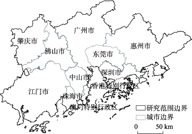
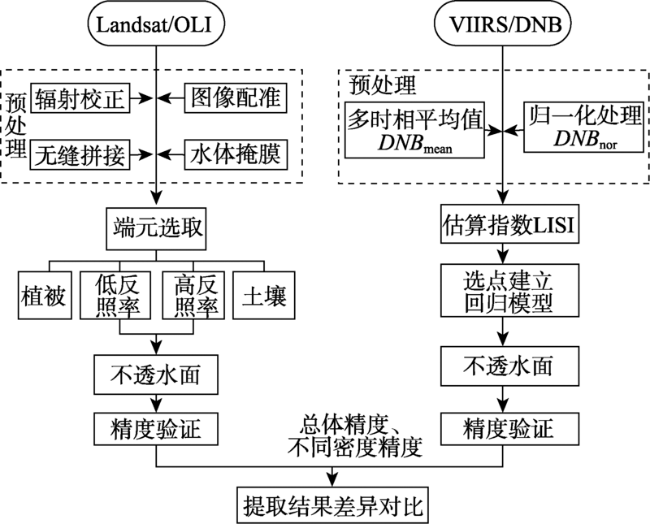
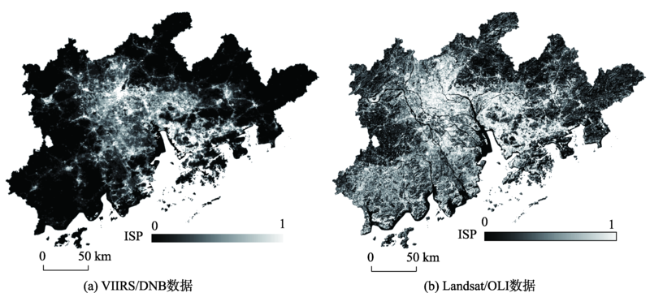
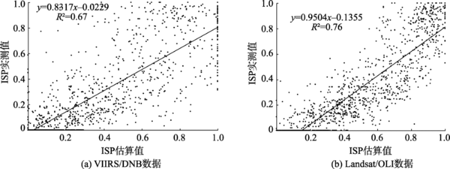
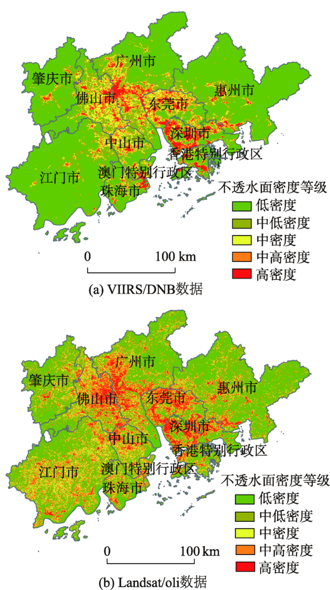
Impervious surface is considered as a major indicator of the degree of urbanization and also an important indicator of environmental quality. Currently, impervious surface extraction is usually based on remote sensing data, including different resolution remote sensing data sources. In extracting high-precision impervious surface, there would be great differences in extraction accuracy caused by different spatial scales. Therefore, it is necessary to explore impervious surface extraction characteristics with different remote sensing data sources. This paper used Landsat/OLI spectral data and VIIRS/DNB nighttime data to extract impervious surface and compare their extraction accuracy difference. The primary objective of this study was to determine the optimal data sources for estimating Impervious Surface Percentage (ISP) for regions with different density of impervious surface distribution. Firstly, Linear Spectral Mixture Analysis (LSMA) was used to extract impervious surface with Landsat/OLI data, and Large-scale Impervious Surface Index (LISI) was used to estimate ISP with VIIRS/DNB data. Then, accuracy of the impervious surface extraction results from these two data sources was assessed respectively, based on the Root Mean Square Error (RMSE), Systematic Error (SE), and coefficient of determination (R 2). The accuracy results showed that the overall ISP accuracy based on the Landsat/OLI data was slightly better than that based on the VIIRS/DNB data, with the overall RMSE being 0.18 and 0.21, SE 0.12 and 0.13, and R 2 0.76 and 0.67, respectively. The accuracy assessments from different density results of impervious surface indicated that the extraction capabilities of Landsat/OLI data and VIIRS/DNB data were greatly different for regions with different density of impervious surface distribution. In the region of low-density impervious surface distribution, the extraction accuracy of impervious surface results based on VIIRS/DNB data was better than based on Landsat/OLI data, because the impervious surface information can be effectively distinguished based on light brightness of VIIRS/DNB data. The impervious surface extraction results from Landsat/OLI data had better accuracy in the areas of medium and high-density impervious surface distribution, because the spatial details of high-density urban impervious surface can be extracted more effectively by the spectral differences of Landsat/OLI data. In future studies, more research is needed to explore the impervious surface extraction characteristics with remote sensing data at different spatial scales and to determine the optimal data sources for effectively and accurately estimating impervious surface.
FENG Shanshan , FAN Fenglei . Accuracy Comparison between Landsat/OLI and Nighttime Light Data in Extracting Urban Impervious Surface[J]. Journal of Geo-information Science, 2019 , 21(10) : 1608 -1618 . DOI: 10.12082/dqxxkx.2019.190102
表1 研究数据信息Tab. 1 Information of the used imagery |
| 数据类型 | 条带号/行编号 | 获取时间 |
|---|---|---|
| Landsat/OLI | 121/044 121/045 122/044 122/045 123/044 123/045 | 2016-12-16 2016-09-27 2015-10-18 2016-02-07 2016-03-01 2016-11-28 |
| VIIRS/DNB (Monthly) | 75N/060E 75N/060E 75N/060E | 2016-01 2016-07 2016-12 |
| MODIS NDVI (MYD13Q1) | v06/h28 v06/h28 v06/h28 | 2016-02-10 2016-07-19 2016-12-26 |
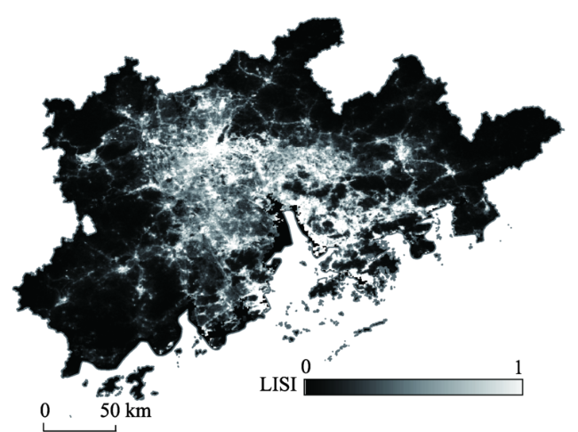
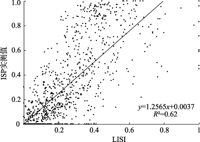
图4 LISI结果与对应不透水面实测值之间的关系Fig. 4 Relationship between LISI and real impervious surface measurements |
图6 不透水面估算值与对应实测值之间的关系Fig. 6 Relationship between real and estimated impervious surface results |
表2 VIIRS/DNB与Landsat/OLI数据不透水面的整体精度对比Tab. 2 Comparison of overall extraction accuracy by using VIIRS/DNB versus Landsat/OLI data |
| 数据 | R2 | RMSE | SE |
|---|---|---|---|
| VIIRS/DNB | 0.67 | 0.21 | 0.13 |
| Landsat/OLI | 0.77 | 0.18 | 0.12 |
表3 VIIRS/DNB与Landsat/OLI数据在不同密度不透水面的精度对比Tab. 3 Comparison of extraction accuracy by using VIIRS/DNB verus Landsat/OLI data in areas of different densities of impervious surface |
| 密度范围 | RMSE | SE | |||
|---|---|---|---|---|---|
| VIIRS/ DNB | Landsat/ OLI | VIIRS/ DNB | Landsat/ OLI | ||
| 0≤ ISP <0.2 | 0.16 | 0.20 | -0.09 | 0.16 | |
| 0.2≤ ISP <0.4 | 0.26 | 0.21 | 0.15 | 0.16 | |
| 0.4≤ ISP <0.6 | 0.29 | 0.23 | 0.16 | 0.15 | |
| 0.6≤ ISP <0.8 | 0.24 | 0.18 | 0.14 | 0.13 | |
| 0.8≤ ISP ≤1 | 0.21 | 0.10 | 0.13 | -0.02 | |
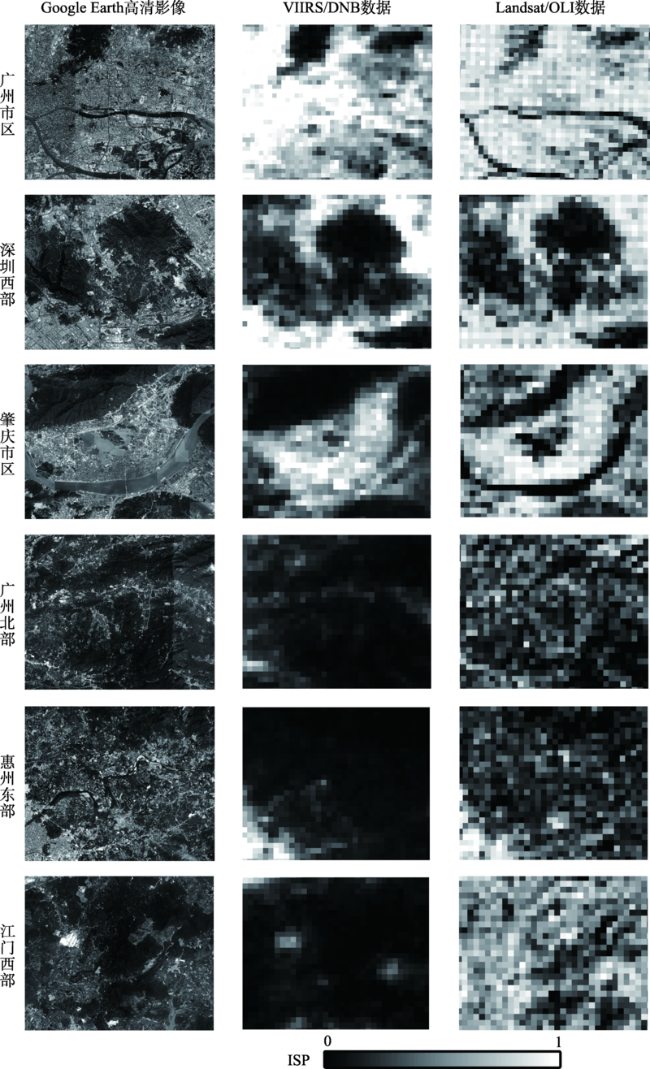
图8 典型区域不透水面分布注:第1列是6个区域的Google Earth高清影像;第2、3列分别是基于VIIRS/DNB、Landsat/OLI数据在6个区域的不透水面提取结果。 Fig. 8 Impervious surface distribution in typical regions |
表4 VIIRS/DNB与Landsat/OLI数据在不同区域不透水面的精度对比Tab. 4 Comparison of extraction accuracy by using VIIRS/DNB versus Landsat/OLI data in typical areas |
| 典型 区域 | RMSE | SE | |||
|---|---|---|---|---|---|
| VIIRS/ DNB | Landsat/ OLI | VIIRS/ DNB | Landsat/ OLI | ||
| 广州市区 | 0.28 | 0.13 | 0.14 | -0.05 | |
| 深圳西部 | 0.24 | 0.13 | 0.14 | -0.08 | |
| 肇庆市区 | 0.22 | 0.20 | 0.10 | 0.11 | |
| 广州北部 | 0.09 | 0.21 | 0.01 | 0.15 | |
| 惠州东部 | 0.13 | 0.25 | -0.04 | 0.18 | |
| 江门西部 | 0.08 | 0.29 | 0.03 | 0.23 | |
| [1] |
|
| [2] |
|
| [3] |
|
| [4] |
|
| [5] |
|
| [6] |
|
| [7] |
徐涵秋 . 基于城市地表参数变化的城市热岛效应分析[J]. 生态学报, 2011,31(14):3890-3901.
[
|
| [8] |
樊智宇, 詹庆明, 刘慧民 , 等. 武汉市夏季城市热岛与不透水面增温强度时空分布[J]. 地球信息科学学报, 2019,21(2):226-235.
[
|
| [9] |
|
| [10] |
徐涵秋, 王美雅 . 地表不透水面信息遥感的主要方法分析[J]. 遥感学报, 2016,20(5):1270-1289.
[
|
| [11] |
|
| [12] |
|
| [13] |
岳文泽, 吴次芳 . 基于混合光谱分解的城市不透水面分布估算[J]. 遥感学报, 2007,11(6):914-922.
[
|
| [14] |
|
| [15] |
|
| [16] |
|
| [17] |
|
| [18] |
|
| [19] |
|
| [20] |
向超, 朱翔, 胡德勇 , 等. 近20年京津唐地区不透水面变化的遥感监测[J]. 地球信息科学学报, 2018,20(5):684-693.
[
|
| [21] |
|
| [22] |
|
| [23] |
|
| [24] |
|
| [25] |
程熙, 沈占锋, 骆剑承 , 等. “全域一局部”不透水面信息遥感分步提取模型[J]. 遥感学报, 2013,17(5):1191-1205.
[
|
| [26] |
|
| [27] |
|
| [28] |
|
| [29] |
|
| [30] |
|
| [31] |
|
| [32] |
|
| [33] |
|
| [34] |
|
| [35] |
|
| [36] |
|
| [37] |
|
/
| 〈 |
|
〉 |