Construction Land Expansion in the Mohan-Boten Port Area between China and Laos in the Geoeconomic Cooperation Context

  • XIAO Chiwei 1, 2, 3 ,
  • RAO Didi 1, 2 ,
  • LIU Yiyuan 3 ,
  • FENG Zhiming 1, 2, 4 ,
  • LI Peng , 1, 2, *
Expand
  • 1. Institute of Geographic Sciences and Natural Resources Research, Chinese Academy of Sciences, Beijing 100101, China
  • 2. College of Resources and Environment, University of Chinese Academy of Sciences, Beijing 100049, China
  • 3. College of Geography and Environment, Jiangxi Normal University, Nanchang 330022, China
  • 4 Key Laboratory of Carrying Capacity Assessment for Resource and Environment, Ministry of Natural Resources, Beijing 101149, China
*LI Peng, E-mail:

Received date: 2019-02-11

  Request revised date: 2019-04-10

  Online published: 2019-10-29

Supported by

National Natural Science Foundation of China(41971242)

Program for BINGWEI Excellent Young Talents of Institute of Geographic Sciences and Natural Resources Research, Chinese Academy of Sciences(2018RC201)

Strategic Pilot Science and Technology Project of Chinese Academy of Sciences(Category A)(XDA20010201)

Key Laboratory of Poyang Lake Wetland and Watershed Research, Ministry of Education, Jiangxi Normal University(PK2019005)

Copyright

Copyright reserved © 2019

Abstract

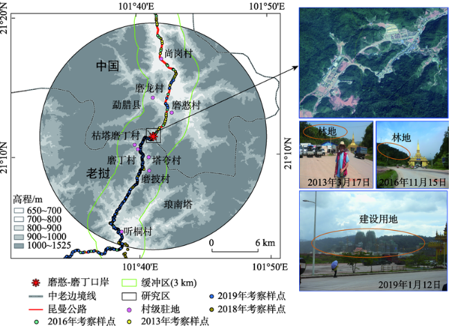
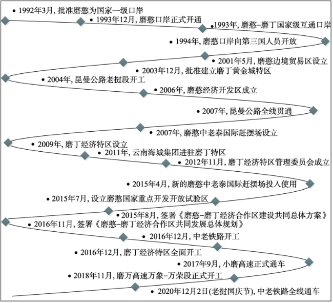
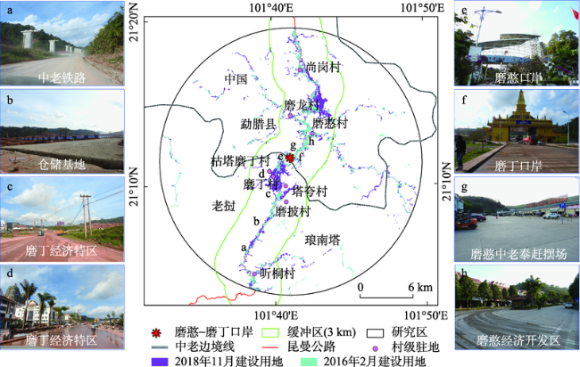
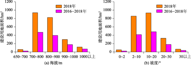
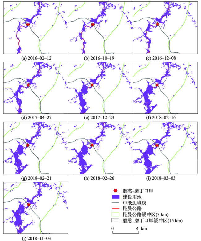
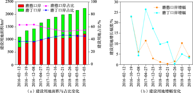
Since the 1990s, driven by the geoeconomic cooperation mechanisms, Laos, the only land-locked country in mainland Southeast Asia, has been experiencing rapid land use/cover change (LUCC) dominated by expansion of construction land, especially in its borderlands with adjacent countries (e.g. China). Taken the Mohan-Boten Port between China and Laos as the study area, a total of ten Sentinel-2 A/B 10m spatial resolution images (with none or little cloud coverage) from February 2016 to November 2018 were used to map the construction land through object-oriented classification and post-classification visual adjustments. The spatio-temporal change pattern and national difference of construction land in a 15 km buffer area of the Mohan-Boten Port, were analyzed and revealed via spatial and statistical analyses with ArcGIS 10.x software. Results showed that: (1) The area of construction land increased rapidly from 1098.8 hm 2 in early 2016 to 2238.8 hm 2 by the end of 2018 in the Mohan-Boten Port area. In particular, about 50.8% of the newly established construction land were located at elevations between 800 m and 1000 m and 80.9% on slopes below 20°. (2) During 2016-2018, the area of construction land increased from 695.4 hm 2 to 1226.7 hm 2 in the Mohan Port, with a growing rate of ca. 6.7%, while the proportion of the total area of construction land declined from 63.3% to 54.8%. (3) The construction land significantly increased by 1.5 times in the adjacent area of Boten Port, i.e., from 403.4 hm 2 to 1012.1 hm 2 in the same period and grew at an average rate of 11.1%. Moreover, the proportion of construction land increased from 36.7% to 45.2%, increased by 8.5% in the study area. We concluded that the developing geoeconomic cooperation is a dominant factor for land use change in the borderland between China and Laos, especially in the port area.

Cite this article

XIAO Chiwei , RAO Didi , LIU Yiyuan , FENG Zhiming , LI Peng . Construction Land Expansion in the Mohan-Boten Port Area between China and Laos in the Geoeconomic Cooperation Context[J]. Journal of Geo-information Science, 2019 , 21(10) : 1576 -1585 . DOI: 10.12082/dqxxkx.2019.190053v

1 引言

口岸(Border Port)是国家对外开放的门户,深受毗邻国家地缘政治、地缘经济的影响,并为跨境经济合作提供了必要载体[1]。在区域经济一体化的推动下,地缘上毗邻国家通过建立合作机制,优先在其边境地区进行资源开发、产业互补等经贸合作,口岸地区当仁不让。自1992年大湄公河次区域经济合作机制(Greater Mekong Subregion Cooperation, GMS)发起以来,中南半岛/东南亚国家与域外大国和国际组织已建立30余个地缘政治/经济合作机制,并成为全球经济发展最快的地区之一[2]。其中,地缘经济合作正以不同方式、不同维度、不同程度影响区域土地利用与覆被变化(Land Use/Cover Change, LUCC)[3,4,5],各国边境地区(尤其是双边口岸)首当其冲。边境地区作为国家实施地缘战略的前沿,包括重点开发开放试验区、边境经济合作区、跨境经济合作区、沿边口岸和边境城市,日益成为LUCC的活跃地带和新的研究生长点[6],并将成为未来较长时期内LUCC研究的优先关注区域与方向。相较于传统边境研究侧重于经贸、冲突与安全、文化与社会建构与跨境合作而言[7],因意识形态对抗、地缘环境封闭与人类活动影响微弱,过去边境LUCC研究重视不够[4],特别是鲜有从口岸视角开展地缘经济对LUCC的影响及其响应研究。
在地缘经济合作背景下,受人口增长、区域互联互通与边境合作等影响,中南半岛国家(含老 挝)及其边境地区已经或正在经历快速而广泛的LUCC,包括森林缩减[5,8]、橡胶林跨境种植[9,10,11]、刀 耕火种农业演变等[12,13,14,15]。地缘经济合作,可以视作国家对外政策导向转变或调整对边境LUCC的“自然实验”[16]。作为中南半岛地理意义上的中心国家,也是“一带一路”倡议下(Belt and Road Initiative, BRI)中国在中南半岛的重要节点,老挝正在为摆脱最不发达国家行列而努力,如提出变“陆锁国(Land-locked)”为“陆联国(Land-linked)”。当前,老挝力图通过互联互通使其成为中南半岛的枢纽或通道,同时也深受越南、中国、泰国等邻国的地缘影 响[11,17]。放眼全球,有关地缘经济影响下的边境地区LUCC研究日益受到关注,如东欧剧变/苏联解体引起的社会经济突变对乌克兰-波兰-捷克交界地区的土地覆被与景观差异[16]、美-墨边境城市扩张与土地覆被变化[18]、玻利维亚-巴西-秘鲁接壤地区跨境设施建设与土地覆被变化[4]、及纳米比亚-安哥拉边境地区城镇扩张与农村土地利用转型[19]等。
与全球其它边境LUCC研究相比,东南亚/中南半岛国家边境LUCC研究也陆续受到关注,但仅限于某些国家边境的特殊地类,如中-老-缅边境[9,20]和柬-越边境[21,22]的橡胶林扩展与自然林缩减、印尼-马来西亚边境的森林变化[23]、以及中南半岛边境地区刀耕火种农业演变[24,25]。老挝是中南半岛唯一内陆国家,同时与中国、越南、柬埔寨、泰国与缅甸接壤,是开展边境LUCC与地缘经济合作交叉互动研究的理想区域。受中老两国地缘经济合作影响,当前老挝磨丁经济特区以及中老铁路、磨(丁)-万(象)高速建设如火如荼,边境特别是口岸地区建设用地扩张现象日益明显。2013-2019年,先后5次实地考察了磨憨-磨丁口岸地区的土地利用/覆被情况,切身感受到口岸两侧以建设用地扩张为主的LUCC。然而,当前有关中老边境LUCC研究还很零星[5],特别是鲜有报道地缘经济合作背景下的边境/口岸地区建设用地扩张分析。同时,2015年欧空局(European Space Agency, ESA)发布的哨兵2号(Sentinel-2)更高空间分辨率(10 m/20 m)卫星产品,为边境地区(口岸)开展精细尺度的土地利用变化研究提供了新的数据基础。
基于此,本研究利用2016年2月-2018年11月共10景Sentinel-2A/B遥感数据与2013-2019年野外定位景观照片,采用面向对象与后期人工修改相结合的方法,提取了磨憨-磨丁口岸(15 km缓冲区)2016-2018年多期建设用地的空间分布信息。在此基础上,分析了地缘经济合作背景下中老磨憨-磨丁口岸的时空变化规律及国别差异。基于高分辨率Sentinel-2 A/B数据,开展地缘经济背景下中老边境地区口岸扩张等先周边后全球的地缘问题研究,对中国构建中国-中南半岛经济走廊及边境发展具有重要现实意义,以期为后续从地理学空间视角开展中南半岛国家边境LUCC的地缘经济影响与响应研究提供方法基础等。本文也是对中国地理学界(者)呼吁加强地理学空间视角研究地缘经济问题的积极回应与具体实践[26]

2 研究区概况、数据源与研究方法

2.1 研究区概况

磨憨和磨丁(Boten) 2个国家级口岸分别位于中国勐腊县最南端与老挝琅南塔省北部(图1),在中国昆(明)-曼(谷)公路小磨段(G213公路)南端与老挝13公路起点交汇处(21°11′N, 101°41′E)。中老磨憨-磨丁口岸地区地处横断山系南向延伸部分,海拔在1500 m以下,以坝子、低山丘陵为主。属热带季风气候区,一年分为雨季(5月下旬至10月下旬)和旱季(10月中旬至次年5月中旬)。磨憨-磨丁口岸热带植物多样性丰富,植被覆盖率较高。中老磨憨-磨丁口岸于1993年正式开通,是中老唯一一对一类国家级陆路口岸,是我国通往中南半岛乃至东南亚的重要节点,在中国面向中南半岛对外连通中占据关键位置(桥头堡)。
图1 研究区位置与野外实地考察照片

注:该图基于国家测绘地理信息局标准底图服务网站下载的审图号为GS(2016)2890 号的标准底图比照制作。

Fig. 1 Location of the study area and landscape photos

根据1990年代以来中老磨憨—磨丁口岸/边境经济合作区的发展历程(图2),不难看出中老双方的一系列地缘政治经济合作机制促进了中老边境地区(磨憨-磨丁口岸尤甚)的长足发展。特别地,依托中老磨憨-磨丁口岸,老挝建立了磨丁经济特区并于2016年12月全面开工。相应地,中国在中老边境地区建立了中国第二个跨境经济合作区——中国磨憨-老挝磨丁跨境经济合作区。近3年(2016-2018年)来的地缘经济合作,已促使边境(口岸尤甚)地区土地利用/覆被发生井喷式变化。当前,磨憨-磨丁口岸、磨丁经济特区及跨境经济合作区方兴未艾,随着小勐养高速公路、泛亚高铁中线(中老铁路)、以及勐腊支线机场的建设,加之澜沧江-湄公河水路的升级治理,磨憨-磨丁将成为一个兼具水、陆、空、铁通道的国际口岸,将给中老边境地区的发展带来前所未有的机遇,其引起的区域LUCC与景观变化亟待研究和探索。
图2 1990-2020年中老磨憨-磨丁口岸发展历程

Fig. 2 Development timeline of the Mohan-Boten Port of Sino-Lao from 1990 to 2020

2.2 数据源及预处理

2.2.1 Sentinel-2影像数据
Sentinel-2卫星是欧空局(ESA)和欧盟委员会(European Commission)共同倡议的全球环境与安全监测系统“哥白尼计划”中的第二颗卫星[27]。Sentinel-2共包含A、B双星,双星同时运行,将重访周期缩短至5 d,从而极大地增强了对地观测能力,并分别于2015年12月、2017年7月免费共享数据。考虑到Sentinel-2数据可获取性及其高时空分辨率、成像时间和覆盖范围,本文主要采用2016年2月至2018年11月覆盖中老边境地区(含磨憨—磨丁口岸)无云或少云的10景影像(表1)进行建设用地信息提取。为减少误差,研究区内(即磨憨—磨丁口岸15 km缓冲区)影像均未受到云影影响。原始影像来源于ESA(https://scihub.copernicus.eu/dhus/#/home),均为已经过几何校正的大气顶反射率数据(L1C)。基于欧空局Sentinel Application Platform(SNAP)软件中Sen2cor插件进行大气校正,得到L2A数据,并重采样至20 m空间分辨率。
表1 研究区2016-2018年所使用的Sentinel-2影像数据列表

Tab. 1 List of the Sentinel-2 images for the study area from 2016 to 2018

序号 影像获取时间 云量/% 序号 影像获取时间 云量/%
1 2016-02-12 0.0 6 2018-02-16 0.0
2 2016-10-19 1.7 7 2018-02-21 1.2
3 2016-12-08 6.3 8 2018-02-26 0.6
4 2017-04-27 3.1 9 2018-03-03 0
5 2017-12-23 11.6 10 2018-11-03 0.0

2.2.2 高程数据

2009年6月30日,美国航天局(NASA)与日本经济产业省(METI)合作推出了先进星载热发射和反射辐射仪全球数字高程模型(Advanced Spaceborne Theemal Emission and Reflection Radiometer Global Digital Elevation Model, ASTER GDEM),并于2011年发布了第二版本,其全球空间分辨率为1弧度秒(约30 m)[28]。本文的ASTER GDEM V2免费获取于日本地球遥感数据数据分析中心(ERSDA, Earth Remote Sensing Data Analysis Center)(http://www.ersdac.gdem.aster.or.jp/),同时还进行了云处理、残余异常值剔除。本文高程数据在前期中国-中南半岛地形研究的基础上[29,30],通过研究区矢量界线裁剪获得,并提取了坡度信息,主要用于分析研究区建设用地及其扩展的海拔与坡度分布特征。

2.3 研究方法

近年来,面向对象的遥感影像分类法在高分辨率影像(如Sentinel)信息提取中得到广泛应用[31,32]。较传统分类方法而言,面向对象分类方法充分利用地物的光谱、形状结构、纹理和专题属性等信息,一定程度上提高了分类的准确性和稳定性[33]。本研究基于eCognition Developer 8.7软件,利用面向对象方法,在考虑影像地物颜色因子和形状因子的基础上,结合植被和水体、耕地等非植被掩膜提取了研究区建设用地信息。需要说明的是,本文的建设用地主要包括:城镇/农村居民点用地、交通建设用地、仓储用地、以及以上地类周边正在开发建设中的裸地等(图3)。此外,基于2018年Google Earth影像,结合2013年3月、2016年11月、2018年5-9月与2019年1月先后五次中老边境实地口岸调查所收集的点位照片(图1)等先验知识,对解译结果进行目视修正。
图3 中老磨憨—磨丁口岸地区2016年2月与2018年11月建设用地空间分布

注:该图基于国家测绘地理信息局标准底图服务网站下载的审图号为GS(2016)2890号的标准底图比照制作,底图无修改。

Fig. 3 Map of the construction land distribution in the Mohan-Boten Port of Sino-Lao between February 2016 and November 2018

3 结果及分析

3.1 中老磨憨-磨丁口岸建设用地分布现状

以中老磨憨-磨丁口岸15 km缓冲区为研究对象,分别提取了研究区2016-2018年10期建设用地分布信息。基期(2016年2月)和最新(2018年11月)建设用地空间分布信息如图3所示。2018年11月,缓冲区内建设用地面积为2238.8 hm2,其中磨憨口岸侧占54.8%(1226.7 hm2),磨丁口岸侧的面积为1012.1 hm2。特别是,2016-2018年,90.6%的新增建设用地由林地转化而来,其余部分由耕地与其他地类(9.4%)转化而来。磨憨口岸的建设用地现状分布是经过20余年发展而来,而磨丁口岸的发展则出现在近3年。可见,地缘经济合作正在快速加剧老挝边境一侧的土地利用变化。在可预见的未来,磨丁口岸侧建设用地扩张势头强劲,森林缩减严重,区域土地覆被变化突出。
除时间上扩张速度差异大外,中老磨憨-磨丁口岸两侧建设用地蔓延也表现出2种空间特征:① 这种扩张总体上沿昆曼公路呈“条带式”分布;② 在近老挝磨丁口岸和中国远磨憨口岸高度集聚。相对而言,中国一侧建设用地的线状分布特征更明显,而老挝则以近口岸分布为特征;未来其土地利用变化空间特征同样值得持续关注。磨憨口岸地区建设用地以相对远离口岸地区的尚勇镇、磨憨镇为主,是磨憨经济开发区的主要组成部分;而磨丁口岸的建设用地则主要集中在近口岸区域的磨丁村(B. Boten)、枯塔磨丁村(B. Khoumtalatboten)与塔夸村(B. Tomkua)等,是当前磨丁经济特区的核心区域(图3)。此外,分析发现,就海拔而论,当前超过81.1%的建设用地分布在900 m以下区域,其中800 m以下区域占44.2%(图4),主要分布在尚勇镇、磨憨镇,而800~900 m建设用地集聚在磨丁经济特区及近磨憨口岸地区,占到36.9%。就坡度而言,当前82.3%(1842.1 hm2)的建设用地集中在坡度20°以下,其中10°~20°的区域占到41.7%(933.1 hm2),主要分布在磨憨镇、尚勇镇和老挝侧的磨丁村、枯塔磨丁村。从全区来看,建设用地还有很大发展空间。
图4 2016-2018年中老磨憨-磨丁口岸(15 km缓冲区)建设用地的海拔与坡度分布

Fig. 4 Elevational and slope distribution of the construction land in the 15 km buffer area of the Mohan-Boten Port of Sino-Lao from 2016 to 2018

3.2 中老磨憨-磨丁口岸建设用地扩展特征及国别对比

2016年以来,中老磨憨-磨丁口岸经历了阶段性快速发展,缓冲区内的建设用地面积显著增加(图5),其中老挝磨丁经济特区境内尤为明显。2016-2018年,磨憨-磨丁口岸地区建设用地由2016年2月的1098.8 hm2激增到2018年11月的2238.8 hm2,增加了1140.0 hm2。其中,磨憨口岸从695.4 hm2猛增到1226.7 hm2,增加了531.3 hm2;磨丁口岸由403.4 hm2剧增到1012.1 hm2,增加了608.7 hm2,达1.5倍。这一扩张趋势与作者2013年3月16日、2016年11月15日和2018年5月19日、2018年9月25日与2019年1月12日先后五次在中老边境实地考察情况相同。以磨丁口岸区内主要地标(塔銮)西北方向自然景观为例,2013年和2016年老挝近磨丁口岸地区原始森林茂密,而2018年和2019年正在大规模的开发建设磨丁经济特区及中老铁路(图1图3),两阶段的差异明显,清晰可辨。
图5 基于Sentinel-2影像的2016-2018年中老磨憨-磨丁口岸(15 km缓冲区)建设用地扩张变化

注:该图基于国家测绘地理信息局标准底图服务网站下载的审图号为GS(2016)2890号的标准底图制作。

Fig. 5 Expansion of construction land derived from the Sentinel imagery in the 15 km buffer area of the Mohan-Boten Port of Sino-Lao from February 2016 to November 2018

根据图5可知,中老磨憨-磨丁口岸两侧的建设用地主要沿昆曼公路不断向东西两侧扩张,磨丁口岸侧尤为突出。中国磨憨口岸侧建设用地基础相对较好,其扩张呈远磨憨口岸模式;老挝磨丁口岸侧建设用地规模较小但扩张迅速,其扩张高度积聚在近口岸地区,即磨丁经济特区。进一步分析发现,2016-2018年建设用地面积在海拔800 m以下、800~900 m、900~1000 m分别增加了495.6 hm2、395.6 hm2和176.1 hm2图5)。从坡度上来看,2016-2018年新增建设用地在0~2°、2~10°和10~20°分别为23.8 hm2、415.5 hm2与483.5 hm2。其中,50.8%的新增建设用地集中在海拔800~1000 m,80.9%集中在坡度20°以下,主要分布在老挝侧的磨丁经济特区和中国侧的磨憨镇。随着中老双方地缘合作的进一步加深,中老铁路、磨万公路的全线通车,磨憨-磨丁口岸借助其独特的地理位置优势势必迎来新一轮开发建设,未来潜力十足,不容小觑。

3.3 中老磨憨-磨丁口岸建设用地扩展对地缘经济合作的响应

结合图5图6,2016-2018年,在磨憨-磨丁口岸开通、昆曼公路全线贯通、磨憨经济开发区成立和磨丁经济特区开建等地缘合作的影响下,中国磨憨口岸和老挝磨丁口岸建设用地均大幅度增加,前者的增长幅度(531.3 hm2)明显高于后者(608.7 hm2)。值得注意的是,2016-2018年,磨憨-磨丁口岸的差距不断缩小,但磨丁口岸的规模仍低于同期磨憨口岸。磨丁口岸占磨憨-磨丁口岸建设用地的比重不断上升,从2016年的36.7%递增至2018年的45.2%;磨憨口岸建设用地占比由2016年的63.3%递减至2018年的54.8%,整体呈下降趋势。
图6 2016-2018年中老磨憨-磨丁口岸(15 km缓冲区)建设用地扩张速度差异

Fig. 6 Differences in the expansion rate of construction land in the 15 km buffer area of the Mohan-Boten Port of Sino-Lao between February 2016 and November 2018

此外,由图6可知,2016-2018年中国磨憨口岸和老挝磨丁口岸地区建设用地的增量整体呈现前期增幅较大、后期增幅较小的特征,但两者的增长差异较明显。就中国侧而言,磨憨口岸地区建设用地的平均增幅为6.7%,最大增幅(22.9%)出现在2016年2月-2016年10月。就老挝侧而言,磨丁口岸地区建设用地的平均增幅为11.1%,最大增幅出现在2016年12月-2017年4月,达26.4%。
综上可知,2016-2018年中老磨憨-磨丁口岸的阶段性快速发展深受中老两国实施的地缘经济、地缘合作政策密切相关,尽管在时间上具有一定滞后性。随着中老地缘政治经济合作程度的加深,极大地促进了老挝磨丁口岸的开发建设,磨丁口岸/经济特区等的迅猛发展与中国日益增强的地缘影响及自身借助地缘优势谋求发展密切相关。毋庸置疑,近年来老挝磨丁口岸地区的扩张历程深刻地表征了中老两国关于口岸/边境经济合作区的若干地缘政治经济政策对边境地区LUCC的影响与响应。

4 结论与讨论

本文利用中国磨憨口岸和老挝磨丁口岸2016-2018年Sentinel-2 A/B 遥感影像,基于面向对象分类与分类后目视修改相结合方法,提取了磨憨-磨丁口岸(15 km缓冲区)2016年2月-2018年11月共10期建设用地的空间分布格局,结果表明:
(1)2016-2018年,中老磨憨-磨丁口岸经历了快速发展,由2016年2月的1098.8 hm2激增到2018年11月的2238.8 hm2,增加了1140.0 hm2,其中50.8%的新增建设用地发生在海拔800~1000 m的区域,80.9%集中在坡度20°以下。空间上,中老磨憨-磨丁口岸两侧建设用地沿昆曼公路呈“条带式”分布,相对而言,中国一侧建设用地的线状分布特征更明显,而老挝则以近口岸高度集聚。
(2)在磨憨口岸开通、磨憨经济开发区设立等20余年的地缘经济合作驱动下,中国磨憨口岸建设用地基础较好,其空间扩张呈相对远离磨憨口岸模式。2016-2018年,磨憨口岸建设用地从2016年的695.4 hm2递增到2018年的1226.7 hm2,增加了531.3 hm2,平均增幅为6.7%,相应占比由63.3%递减至54.8%,但规模仍高于同期的磨丁口岸。
(3)在磨丁经济特区开建、磨(丁)-万(象)高速建设等近3年的地缘合作影响下,老挝磨丁口岸建设用地规模小但扩张迅速,空间扩张高度积聚于近磨丁口岸地区。2016-2018年,磨丁口岸建设用地面积增加近1.5倍,从2016年的403.4 hm2增加到2018年的1012.13 hm2,增加了608.7 hm2,但平均增幅高达11.1%,且其占比由36.7%增加到45.2%。
可以预见,未来随着域外大国的介入,更多的交通等基础设施(如中老铁路、泛亚铁路)将陆续变为现实。这些通道型设施建设将进一步对区域沿线国家的土地利用/土地覆被造成不同程度的影响。例如,在2016-2019年老挝土地利用/覆被考察中,注意到老挝磨丁经济开发区正在大规模的开发建设,昆曼公路老挝段及其他主要公路沿线橡胶林成片分布,呈规模化种植。因此,未来有必要进一步系统性强化地缘经济背景下交通廊道、口岸等基础设施建设对边境LUCC的影响与响应研究,如增加影像数据(Landsat)来源,追溯1990年代中老磨憨-磨丁口岸/边境经济合作区整个发展历程的建设用地扩张过程,积极拓展、丰富地缘经济合作与边境土地变化科学的研究范畴、研究内容与方法。当然,磨憨-磨丁口岸/边境地区的发展深受中老地缘经济关系的影响,但中老两国实施的不同口岸/边境管理制度、两侧建设用地的集约水平与效率差异等方面的影响值得关注与探讨。目前,本文只是分析了老挝磨丁经济特区建设初期的建设用地扩张,未来随着特区建设的深入及中老铁路、磨-万高速全线贯通,将加强区域LUCC系统研究。
[1]
郭来喜 . 中国对外开放口岸布局研究[J]. 地理学报, 1994,49(5):385-393.

[ Guo L X . Distribution of ports in China[J]. Acta Geographica Sinica, 1994,49(5):385-393. ]

[2]
Dayley R, Neher C D. Southeast Asia in the new international era (The fifth edition)[J]. Boulder,Colorado: Westview Press, 2013,352.

[3]
Lambin E F, Meyfroidt P . Global land use change, economic globalization, and the looming land scarcity[J]. Proceedings of the National Academy of Sciences, 2011,108(9):3465-3472.

[4]
Perz S G, Qiu Y L, Xia Y B , et al. Trans-boundary infrastructure and land cover change: Highway paving and community-level deforestation in a tri-national frontier in the Amazon[J]. Land Use Policy, 2013,34:27-41.

[5]
Tang D M, Fan H, Yang K , et al. Mapping forest disturbance across the China-Laos border using annual Landsat time series[J]. International Journal of Remote Sensing, 2018,40(8):2895-2915.

[6]
李秋萍, 陆汝成, 李冠 , 等. 边境土地利用变化及其与贸易发展互动关系研究进展[J]. 中国土地科学, 2015,29(8):16-23.

[ Li Q P, Lu R C, Li G , et al. Research progress on regional Land-use change along national border and it's interactive relationship with frontier trade development[J]. China Land Science, 2015,29(8):16-23. ]

[7]
宋涛, 刘卫东, 李玏 . 国外对地缘视野下边境地区的研究进展及其启示[J]. 地理科学进展, 2016,35(3):276-285.

[ Song T, Liu W D, Li L . International research on the border regions with a geopolitical perspective and revelation[J]. Progress in Geography, 2016,35(3):276-285. ]

[8]
Zeng Z Z, Estes L, Ziegler A D , et al. Highland cropland expansion and forest loss in Southeast Asia in the twenty-first century[J]. Nature Geoscience, 2018,11(8):556-562.

[9]
Liu X N, Feng Z M, Jiang L G , et al. Rubber plantation and its relationship with topographical factors in the border region of China, Laos and Myanmar[J]. Journal of Geographical Sciences, 2013,23(6):1019-1040.

[10]
Xiao C W, Li P, Feng Z M . Monitoring annual dynamics of mature rubber plantations in Xishuangbanna during 1987-2018 using Landsat time series data: A multiple normalization approach[J]. International Journal of Applied Earth Observation and Geo-information, 2019,77:30-41.

[11]
李鹏, 封志明 . 地缘经济背景下的老挝橡胶林地扩张监测及其影响研究综述[J]. 地理科学进展, 2016,35(3):286-294.

DOI

[ Li P, Feng Z M . Review of remote sensing monitoring and socioeconomic and environmental impacts of rubber plantation expansion in Laos in the geoeconomic context[J]. Progress in Geography, 2016,35(3):286-294. ]

[12]
Liao C H, Feng Z M, Li P , et al. Monitoring the spatio-temporal dynamics of swidden agriculture and fallow vegetation recovery using Landsat imagery in northern Laos[J]. Journal of Geographical Sciences, 2015,25(10):1218-1234.

[13]
Ziegler A D, Fox J M, Webb E L , et al. Recognizing contemporary roles of swidden agriculture in transforming landscapes of Southeast Asia[J]. Conservation Biology, 2011,25(4):846-848.

[14]
Dressler W, Wilson D, Clendenning J , et al. Examining how long fallow swidden systems impact upon livelihood and ecosystem services outcomes compared with alternative land-uses in the uplands of Southeast Asia[J]. Journal of Development Effectiveness, 2015,7(2):210-229.

[15]
Li P, Feng Z M, Jiang L G , et al. A review of swidden agriculture in Southeast Asia[J]. Remote Sensing, 2014,6(2):1654-1683.

[16]
Kuemmerle T, Radeloff V C, Perzanowski K , et al. Cross-border comparison of land cover and landscape pattern in Eastern Europe using a hybrid classification technique[J]. Remote Sensing of Environment, 2006,103(4):449-464.

[17]
肖池伟, 李鹏, 封志明 , 等. 1976-2013年老挝主要农作物种植结构时空演变特征分析[J]. 世界地理研究, 2017,26(6):31-40.

[ Xiao C W, Li P, Feng Z M , et al. Spatio-temporal change of primary crops in Laos during 1976-2013[J]. World Regional Studies, 2017,26(6):31-40. ]

[18]
Soto-Berelov M, Madsen K D . Continuity and distinction in land cover across a rural stretch of the US-Mexico border[J]. Human Ecology, 2011,39(4):509-526.

[19]
Röder A, Pröpper M, Stellmes M , et al. Assessing urban growth and rural land use transformations in a cross-border situation in Northern Namibia and Southern Angola[J]. Land Use Policy, 2015,42:340-354.

[20]
Chanhda H, Wu C F, Ye Y M , et al. GIS based land suitability assessment along Laos-China border[J]. Journal of Forestry Research, 2010,21(3):343-349.

[21]
Grogan K, Pflugmacher D, Hostert P , et al. Cross-border forest disturbance and the role of natural rubber in mainland Southeast Asia using annual Landsat time series[J]. Remote Sensing of Environment, 2015,169:438-453.

[22]
Ye S, Rogan J, Sangermano F . Monitoring rubber plantation expansion using Landsat data time series and a Shapelet-based approach[J]. ISPRS Journal of Photogrammetry and Remote Sensing, 2018,136:134-143.

[23]
Broich M, Hansen M, Potapov P , et al. Patterns of tree-cover loss along the Indonesia-Malaysia border on Borneo[J]. International Journal of Remote Sensing, 2013,34(16):5748-5760.

[24]
廖谌婳, 封志明, 李鹏 , 等. 缅老泰交界地区刀耕火种农业的时空变化格局[J]. 地理研究, 2014,33(8):1529-1541.

[ Liao C H, Feng Z M, Li P , et al. The spatio-temporal variation of shifting cultivation in the border region of Myanmar, Laos and Thailand[J]. Geographical Research, 2014,33(8):1529-1541. ]

[25]
Li P, Feng Z M . Extent and area of swidden in montane mainland Southeast Asia: Estimation by multi-step thresholds with Landsat-8 OLI data[J]. Remote Sensing, 2016,8(1):44-60.

[26]
Drusch M, Del Bello U, Carlier S , et al. Sentinel-2: ESA's optical high-resolution mission for GMES operational services[J]. Remote Sensing of Environment, 2012,120:25-36.

[27]
陆大道, 杜德斌 . 关于加强地缘政治地缘经济研究的思考[J]. 地理学报, 2013,68(6):723-727.

[ Lu D D, Du D B . Some thoughts on the strengthening of geopolitical and geo-economic studies[J]. Acta Geographica Sinica, 2013,68(6):723-727. ]

[28]
Tachikawa T, Hato M, Kaku M, et al. The characteristics of ASTER GDEM version 2[C]. IEEE International Geoscience and Remote Sensing Symposium, IGARSS Vancouver, Canada, 2011: 24-29.

[29]
Xiao C W, Li P, Feng Z M . Re-delineating mountainous regions with three topographic parameters in Mainland Southeast Asia using ASTER GDEM[J]. Journal of Mountain Science, 2018,15(8):1728-1740.

[30]
Xiao C W, Feng Z M, Li P , et al. Evaluating the suitability of different terrains for sustaining human settlements according to the local elevation range in China using the ASTER GDEM[J]. Journal of Mountain Sciences, 2018,15(12):2741-2751.

[31]
方朝阳, 邬浩, 陶长华 , 等. 鄱阳湖南矶湿地景观信息高分辨率遥感提取[J]. 地球信息科学学报, 2016,18(6):847-856.

DOI

[ Fang C Y, Wu H, Tao C H , et al. The wetland Information extraction research of Nanji wetland in Poyang Lake based on high resolution remote sensing image[J]. Journal of Geo-information Science, 2016,18(6):847-856. ]

[32]
单治彬, 孔金玲, 张永庭 , 等. 面向对象的特色农作物种植遥感调查方法研究[J]. 地球信息科学学报, 2018,20(10):1509-1519.

[ Shan Z B, Kong J L, Zhang Y T , et al. Remote sensing investigation method of object-oriented crops with special characteristics[J]. Journal of Geo-information Science, 2018,20(10):1509-1519. ]

[33]
汤玲英, 刘雯, 杨东 , 等. 基于面向对象方法的Sentinel-1ASAR在洪水监测中的应用[J]. 地球信息科学学报, 2018,20(3):377-384.

[ Tang L Y, Liu W, Yang D , et al. Flooding monitoring application based on the object-oriented method and Sentinel-1A SAR data[J]. Journal of Geo-information Science, 2018,20(3):377-384. ]

Outlines

/