
Journal of Geo-information Science >
A Remote Sensing Image Matching Method based on Dynamic Polar Coordinate Parame-terization
Received date: 2019-02-27
Request revised date: 2019-05-23
Online published: 2019-10-29
Supported by
National Key Research and Development Program of China(2017YFB0503000)
National Natural Science Foundation of China(61841101)
Copyright
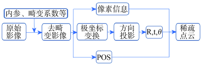
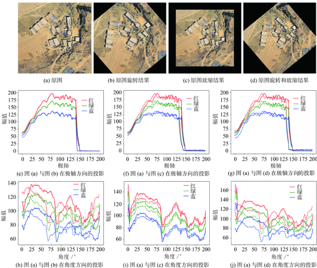
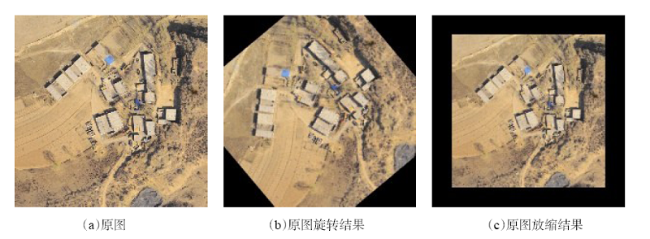
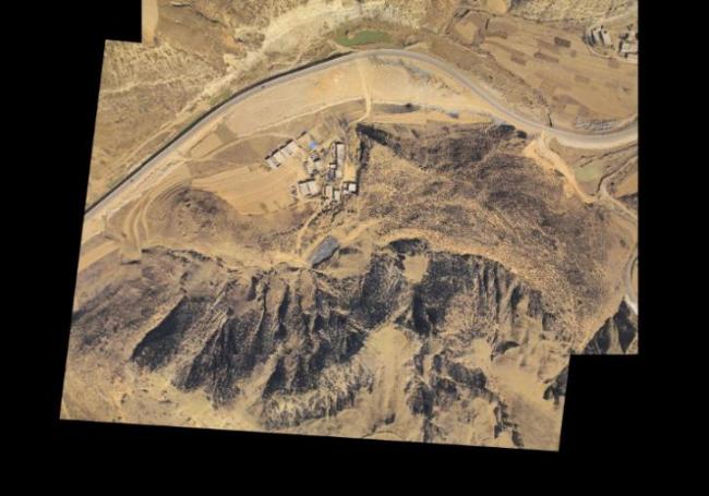
With the promotion of 3D reconstruction technology in various scenarios, especially in 3D reconstruction from remote sensing images, the demand for accurate 3D point clouds are becoming more and more intense. Image matching is an important procedure in 3D reconstruction, and its result directly affects the accuracy of subsequent procedures such as bundle adjustment and orthore.pngication. In feature-intensive areas such as towns and farms, the feature distance is small enough to match well. Based on high confidence, the precision of image matching is high. However, in featureless areas such as grassland and desert, the large feature distance may cause mismatch between images. If the feature point matching method is used, it is difficult to obtain correct pose under high thresholds. If a sufficient number of matching pairs is promoted, the matching pairs will contain many mismatching ones, which will cause failure to image matching, and the sparse point cloud will not be evenly distributed. In this scenario, a forward-looking image matching algorithm based on dynamic polar coordinate parameterization was presented. First, a polar transform was designed to a pair of normal images, a dynamic strategy was designed to solve the problem of uneven sampling in the polar axis direction. The obtained polar coordinate image pair was matched with the least squares method in the rotation and translation directions. After the rotation and translation parameters were calculated, we used the result to compared with the result of the SIFT algorithm. In this paper, two sets of experiments were designed to obtain poses between images: one is to use simulation datasets with known rotation and translation parameters; the other is to use true scene datasets with unknown rotation and translation parameters. In each set of the experiments, we used 3 different pair of images, and 3 different known rotation and translation parameters in the first set. With the same computer hardware, and with two images with a resolution of 7360 pixels * 5400 pixels and depth of 32 bit, the proposed method took about 57% less than the time took by the SIFT algorithm, and the rotation and translation error in the two methods was usually less than 1%. Our findings suggest that the proposed algorithm gets image poses with an accuracy similar to that of the SIFT algorithm, but its time consumption is significantly less. Our algorithm shows good practical application value.
SUN Jiayu , ZUO Zhengkang , SUN Yiyuan , ULLAH Sana , ZHANG Ruihua , ZHAO Haimeng . A Remote Sensing Image Matching Method based on Dynamic Polar Coordinate Parame-terization[J]. Journal of Geo-information Science, 2019 , 21(10) : 1586 -1593 . DOI: 10.12082/dqxxkx.2019.190081
表1 只存在旋转时的匹配结果Tab. 1 Matching results with rotation |
| 操作 | 旋转角度/° | 差异度 | ||
|---|---|---|---|---|
| 实际变换值 | 本文实验结果 | SIFT实验结果 | ||
| 1 | 40 | 41.25 | 41.05 | 0.20 |
| 2 | 60 | 59.50 | 58.00 | 1.50 |
| 3 | 120 | 121.12 | 120.45 | 0.67 |
表2 只存在放缩变换的匹配结果Tab. 2 Matching results with scaling |
| 操作 | 放缩因子/倍 | 差异度 | ||
|---|---|---|---|---|
| 实际变换值 | 本文实验结果 | SIFT实验结果 | ||
| 1 | 1.1 | 1.082 | 1.079 | <0.01 |
| 2 | 1.2 | 1.124 | 1.163 | 0.04 |
| 3 | 0.9 | 0.937 | 0.945 | <0.01 |
表4 3次实验的匹配结果Tab. 4 Image matching results in the three experiments |
| 实验记录 | 本文实验结果 | SIFT实验结果 | 差异度 | |||||
|---|---|---|---|---|---|---|---|---|
| 放缩因子/倍 | 旋转角度/° | 放缩因子/倍 | 旋转角度/° | 放缩因子 | 旋转角度 | |||
| 1 | 1.026 | 5.44 | 1.002 | 4.38 | 0.024 | 0.242 | ||
| 2 | 0.958 | 8.02 | 0.978 | 9.15 | 0.020 | 0.123 | ||
| 3 | 1.034 | 4.69 | 1.056 | 4.92 | 0.021 | 0.146 | ||
表5 3次实验的耗时情况Tab. 5 Time consumption in the three experiments |
| 实验记录 | 本文实验耗时/s | SIFT耗时/s | 节约率/% |
|---|---|---|---|
| 1 | 0.832 | 2.235 | 62.8 |
| 2 | 0.904 | 2.127 | 57.5 |
| 3 | 0.866 | 2.165 | 60.3 |
| [1] |
廖小罕, 周成虎, 苏奋振 , 等. 无人机遥感众创时代[J]. 地球信息科学学报, 2016,18(11):1439-1447.
[
|
| [2] |
郭倩茜 . 图像匹配的主要方法分析[J]. 科技创新与应用, 2016(20):81-81.
[
|
| [3] |
Yitzhaki, Shlomo. "Gini's mean difference: A superior measure of variability for non-normal distributions"[J]. Metron International Journal of Statistics. Springer Verlag, 2003,61(2):285-316.
|
| [4] |
|
| [5] |
陈宁江, 李介谷 . 用归一化灰度组合法进行图像匹配[J]. 红外与激光工程, 2000(5):1-1.
[
|
| [6] |
山海涛, 郭建星, 耿则勋 . 影像匹配中几种相似性测度的分析[J]. 测绘信息与工程, 2003,28(4):11-13.
[
|
| [7] |
|
| [8] |
Harris,
|
| [9] |
|
| [10] |
|
| [11] |
|
| [12] |
|
| [13] |
|
| [14] |
Morel, Jean-Michel, and Guoshen Yu. ASIFT: A new framework for fully affine invariant image comparison[J]. SIAM journal on imaging sciences 2. 2(2009):438-469.
|
| [15] |
|
| [16] |
杨佳宾, 姜永涛, 杨幸彬 , 等. 基于Dense SIFT特征的无人机影像快速拼接方法[J]. 地球信息科学学报, 2019,21(4):588-599.
[
|
| [17] |
宫阿都, 何孝莹, 雷添杰 , 等. 无控制点数据的无人机影像快速处理[J]. 地球信息科学学报, 2011,12(2):254-260.
[
|
| [18] |
|
| [19] |
|
| [20] |
|
/
| 〈 |
|
〉 |
