
Journal of Geo-information Science >
Snow and Vegetation Cover Fractions Mapping Using a Perturbed Mixing Model based on Spectral Normalization
Received date: 2018-05-30
Request revised date: 2019-10-30
Online published: 2019-12-25
Supported by
Strategic Priority Research Program of the Chinese Academy of Sciences(XDA19040504)
Scientific Research Foundation of Sichuan Education Department(15ZA0150)
Scientific Research Foundation of Sichuan Education Department(17ZA0387)
Applied Technology Research and Development Projects of Nanchong City(17YFZJ0014)
Meritocracy Research Funds of China West Normal University(17YC124)
Copyright
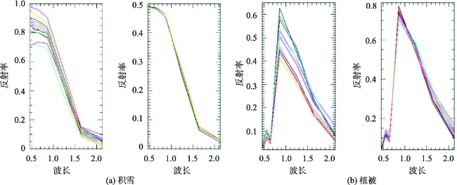
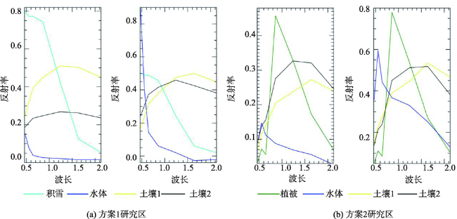
Snow and vegetation cover fractions are important for studying climate change, water resource balance, and eco-environmental conditions. Yet, it is difficult to acquire accurate cover products due to the high spatiotemporal variability of snow and vegetation cover fractions. The enemember variability can result from complex terrains, atmospheric influences, and the intrinsic variability of features such as the chlorophyll concentration in plants, snow particle size, and snow contamination. Supervised spectral unmixing algorithms often assume that the endmembers are known exactly. However, in practice, the endmembers are extracted from real spectral images that may be affected by measurement noises or errors. In addition, available knowledge of the endmembers might not exactly match the actual endmembers of the spectral image at hand, since the spectral signature of the same material may be slightly altered in different images or because distinct but confusingly similar spectral signatures may be mixed up. To solve this problem, this paper proposed a perturbed mixing model (PMM) based on spectral normalization. The PMM attempted to reduce the errors caused by spectral changes and noises by introducing disturbed factors (both image and endmember matrix are perturbed). The PMM model could capture the small noise and endmember variations, yet its accuracy would decrease when the spectrum changed enormously. To solve the problem, the spectral normalization was used to reduce the differences between the endmembers and the spectrum matrix. Spectral normalization did not change the correlation between endmembers and the relative position of high dimensional feature space, but aggregated spectral features of higher correlation coefficients and decreases spectral changes. Then, the PMM was used to quantify the spectral variation and measurement noise/error in order to improve the accuracy of the snow and vegetation cover mapping. Finally, three different areas (snow-dominated region, vegetation-dominated region, and region where snow and vegetation are mixed) were selected to validate the feasibility of the proposed framework. Results show: (1) The root mean square error (RMSE) of snow-dominated region was 0.172, the RMSE of vegetation-dominated region was 0.223, and the RMSE of snow and vegetation mixed region were 0.185 and 0.249, respectively. Relatively high accuracy was achieved in the three types of areas. (2) After normalizing the endmembers and images, the spectral heterogeneity was obviously decreased and the overall accuracy of the three algorithms was better than before normalization. (3) The snow coverage fraction obtained by the framework had higher accuracy than the vegetation coverage fraction.
LI Yang , WANG Jie , HUANG Chunlin . Snow and Vegetation Cover Fractions Mapping Using a Perturbed Mixing Model based on Spectral Normalization[J]. Journal of Geo-information Science, 2019 , 21(12) : 1955 -1964 . DOI: 10.12082/dqxxkx.2019.180259
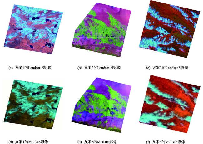
表1 实验方案及影像列表Tab. 1 Experimental schemes and image list |
| 实验方案 | 研究区域 | MODIS和Landsat-5影像编号 | 获取时间 |
|---|---|---|---|
| 方案1 | 石河子 | MOD09GA.A2011194.h24v04.006.2015220020710 LT51440292011194IKR01 | 2011-07-13 2011-07-13 |
| 方案2 | 西藏 | MOD09GA.A2009307.h24v05.006.2015196094516 LT51450362009307KHC00 | 2009-11-03 2009-11-03 |
| 方案3 | 黑河流域 | MOD09GA.A2007257.h25v05.006.2015164195623 LT51340332007257IKR00 | 2007-09-14 2007-09-14 |
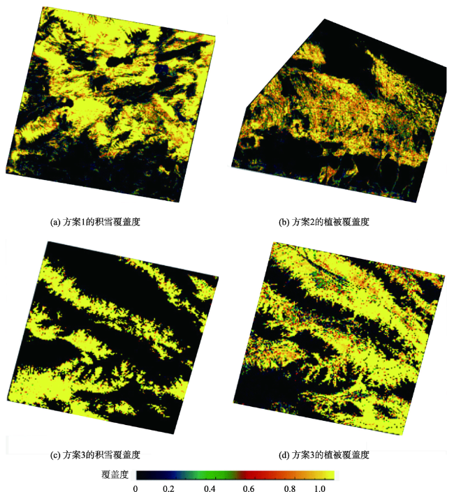
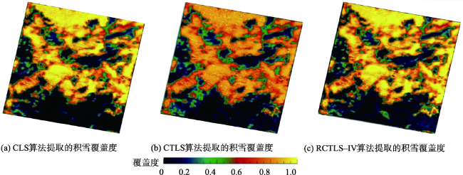
图5 CLS、CTLS和RCTLS-IV算法的方案1解混图像Fig. 5 Unmixing snow images based on the CLS, CTLS, and RCTLS-IV algorithms |
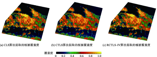
图6 CLS、CTLS和RCTLS-IV算法的方案2解混图像Fig. 6 Unmixing vegetation images based on the CLS, CTLS, and RCTLS-IV algorithms |
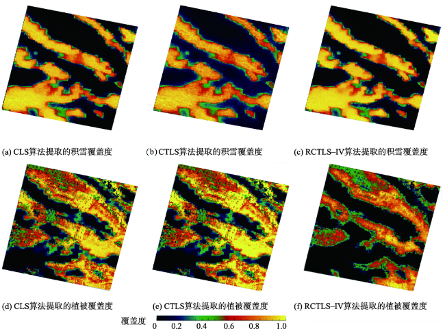
图7 CLS、CTLS和RCTLS-IV算法的方案3解混图像Fig. 7 Unmixing snow and vegetation images based on the CLS, CTLS, and RCTLS-IV algorithms |
表2 3个模型反演的方案1积雪覆盖度精度评估Tab. 2 Accuracy performances of snow cover fraction mapping based on the three algorithms |
| 模型 | RMSE | R | OSD |
|---|---|---|---|
| CLS | 0.172 | 0.914 | 0.005 |
| CTLS | 0.191 | 0.904 | 0.001 |
| RCTLS_IV | 0.184 | 0.912 | 0.009 |
表3 3个模型反演的方案2植被覆盖度精度评估Tab. 3 Accuracy performances of vegetation cover fraction mapping based on the three algorithms |
| 模型 | RMSE | R | OSD |
|---|---|---|---|
| CLS | 0.224 | 0.746 | 0.021 |
| CTLS | 0.237 | 0.737 | 0.035 |
| RCTLS_IV | 0.223 | 0.748 | 0.019 |
表4 3个模型反演的方案3的积雪和植被覆盖度的精度评估Tab. 4 Accuracy performances of snow and vegetation cover fractions mapping based on the three algorithms |
| 模型 | 积雪 | 植被 | |||||
|---|---|---|---|---|---|---|---|
| RMSE | R | OSD | RMSE | R | OSD | ||
| CLS | 0.194 | 0.805 | 0.072 | 0.249 | 0.803 | 0.004 | |
| CTLS | 0.192 | 0.820 | 0.091 | 0.255 | 0.777 | 0.042 | |
| RCTLS_IV | 0.185 | 0.821 | 0.066 | 0.257 | 0.754 | 0.048 |
| [1] |
|
| [2] |
段金亮, 王杰, 张婷 . 一种基于光谱归一化下的植被覆盖度反演算法[J]. 遥感技术与应用, 2018,33(2):252-258.
[
|
| [3] |
|
| [4] |
姜萍, 赖双双, 许婷婷 . ZY-3卫星影像雪盖信息提取方法[J]. 遥感信息, 2019,34(1):123-128.
[
|
| [5] |
|
| [6] |
|
| [7] |
|
| [8] |
|
| [9] |
|
| [10] |
|
| [11] |
|
| [12] |
王杰, 黄春林, 郝晓华 . 一种考虑雪粒径变化的积雪面积反演算法[J]. 地球信息科学学报, 2017,19(1):101-109.
[
|
| [13] |
|
| [14] |
|
| [15] |
|
| [16] |
|
| [17] |
|
| [18] |
|
| [19] |
|
| [20] |
|
| [21] |
|
| [22] |
|
| [23] |
|
| [24] |
|
| [25] |
|
| [26] |
|
| [27] |
|
/
| 〈 |
|
〉 |