
Journal of Geo-information Science >
From Geographic Information System to Intelligent Geographic System
Received date: 2019-12-02
Request revised date: 2019-12-26
Online published: 2020-04-08
Supported by
National Key R&D Program of China(2016YFC1402903)
National Key R&D Program of China(2016YFC1402902)
Copyright
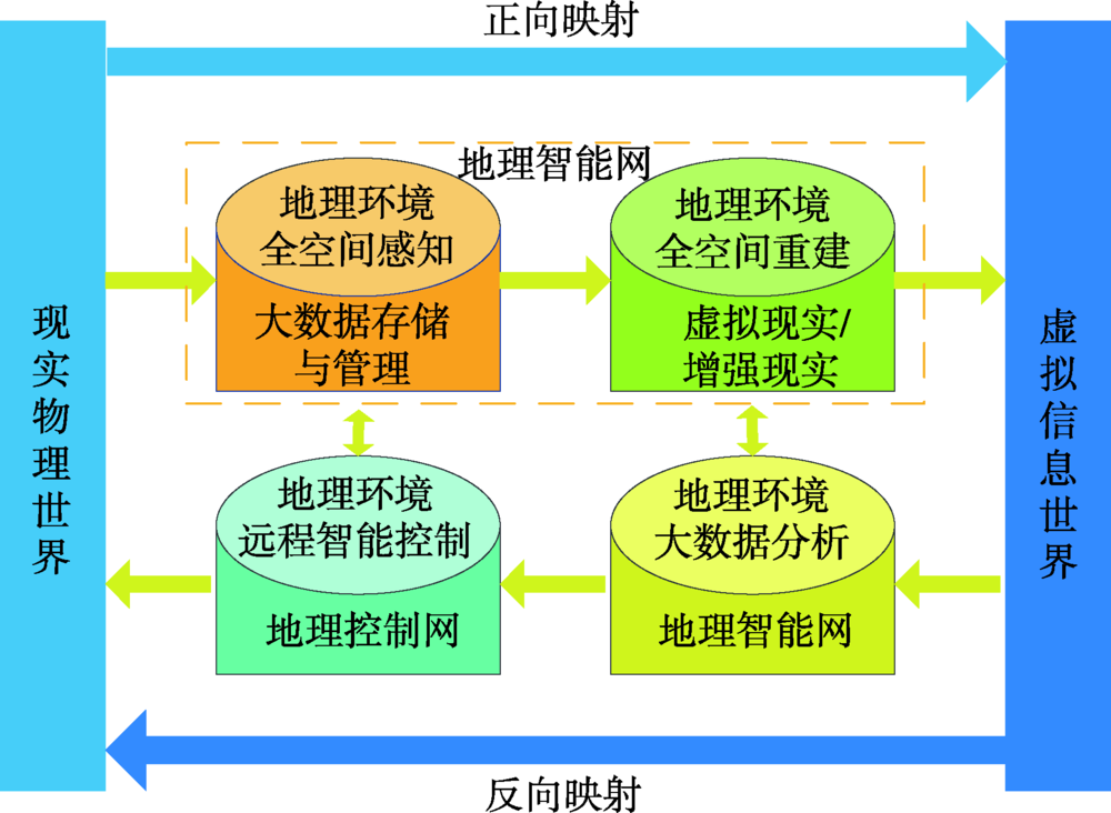
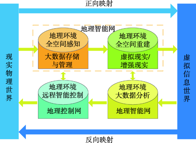
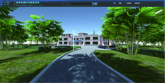
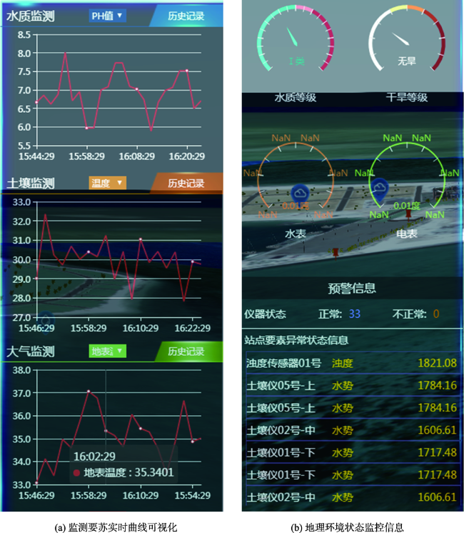
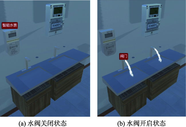
Geographical system, composed of natural and human elements, distributed in the earth's surface space, is provided with the functions of generating, maintaining or transforming material forms and energy forms, or driving the flow of material and energy. It is characterized by natural and human elements and their interactions on spatial distribution, structure, pattern, evolution and function factors. Geographical system is an objective reality system which generally consisted in earth with multi-levels. The geographic system was represented by the geographic information system by a information world with digital form. Then make the plans to transform geographical system by investigating and analyzing the received information. Therefore, two geographic systems, namely real geographic system and information geographic system, are co-existed for a long time and evolved independently. In recent years, with the integration of real-time observation and Internet of Things Technology (IoT), the real-time representation from the real geographic system represented into the information geographic system is coming true. Therefore, two systems evolve no longer independently, and the information geographic system is becoming a mirror of the real geographic system. Once the real geographic system changes, the information geographic system changes simultaneously. At present, the development with an unprecedented speed of human science and technology, especially the cloud services, big data and artificial intelligence, makes the information geographic system no longer be satisfied with being a mirror of the real geographic system. The artificial intelligence and unmanned automation control technology are adopted to achieve the integration of the real world and information world. The real geographic system can be changed through the operation of information geographic system. In the future, the boundary between the real geographic system and the information geographic system will become blurred and the two systems will be fully integrated with no distinguish at last. This article takes the intelligent geographic system to indicate this system, which integrates two worlds, and uses an unattended intelligent system designed for the South Island Reef as an example to show the integration and interoperation of the real geographic system and the information geographic system. The system realizes unmanned and intelligent monitoring, protection, response and operation for the island reef geographic environment and artificial facilities.
SU Fenzhen , WU Wenzhou , ZHANG Yu , KANG Lu , LI Xiaoen . From Geographic Information System to Intelligent Geographic System[J]. Journal of Geo-information Science, 2020 , 22(1) : 2 -10 . DOI: 10.12082/dqxxkx.2020.190802
| [1] |
钱学森, 于景元, 戴汝为 . 一个科学新领域——开放的复杂巨系统及其方法论[J]. 自然杂志, 1990,13(1):3-10.
[
|
| [2] |
陈述彭 . 地理系统与地理信息系统[J]. 地理学报, 1991,13(1):3-9.
[
|
| [3] |
龚健雅 . 地理信息系统基础[M]. 北京: 科学出版社, 2001.
[
|
| [4] |
陈述彭 . 地理信息系统导论[M]. 北京: 科学出版社, 1999.
[
|
| [5] |
吴信才 . 地理信息系统原理与方法[M]. 北京: 电子工业出版社, 2014.
[
|
| [6] |
|
| [7] |
李德仁, 龚健雅, 邵振峰 . 从数字地球到智慧地球[J]. 武汉大学学报·信息科学版, 2010, 35(2): 127-132, 253-254.
[
|
| [8] |
|
| [9] |
|
| [10] |
李德仁 . 展望大数据时代的地球空间信息学[J]. 测绘学报, 2016,45(4):379-384.
[
|
| [11] |
|
| [12] |
周成虎 . 全空间地理信息系统展望[J]. 地理科学进展, 2015,34(2):129-131.
[
|
| [13] |
苏奋振, 周成虎 . 过程地理信息系统框架基础与原型构建[J]. 地理研究, 2006,25(3):477-484.
[
|
| [14] |
林珲, 黄凤茹, 鲁学军 , 等. 虚拟地理环境认知与表达研究初步[J]. 遥感学报, 2010,14(4):822-838.
[
|
| [15] |
|
/
| 〈 |
|
〉 |