
Journal of Geo-information Science >
Estimation of Surface Moisture of Tidal Flat based on Intensity Data of Terrestrial Laser Scanner
Received date: 2019-05-07
Request revised date: 2019-09-16
Online published: 2020-04-13
Supported by
Shanghai Committee of Science and Technology(18DZ1206400)
National Key Research and Development Program of China(2017YFE0107400)
China Postdoctoral Science Foundation(2017M620141)
Copyright
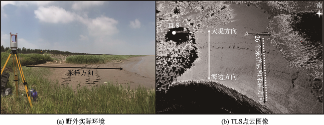
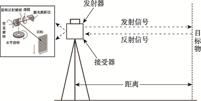
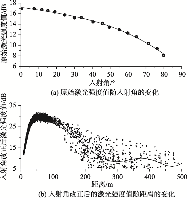
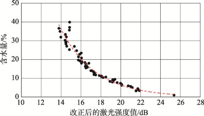
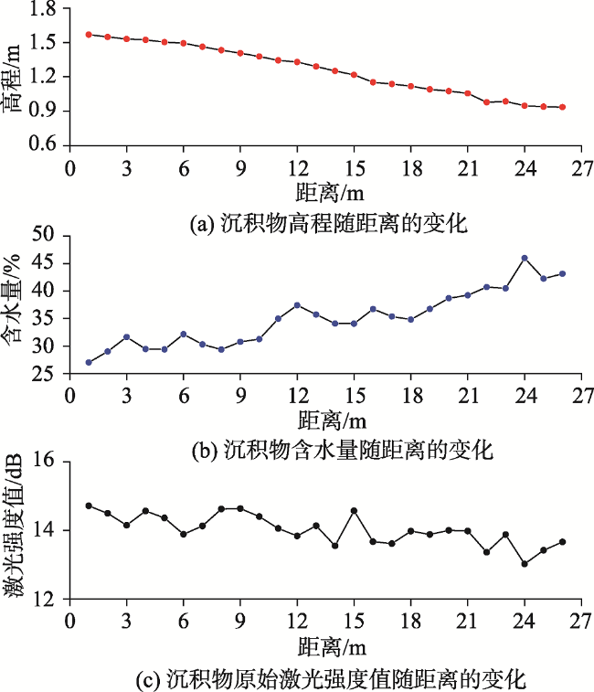
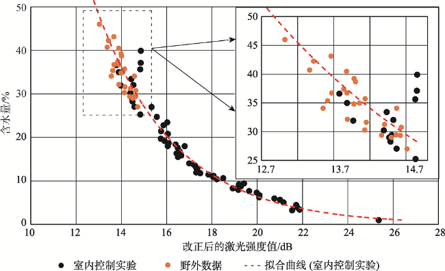
Estimation of surface soil moisture and distributions play a key role in the ecological, environmental, and topographical investigations for intertidal mudflats, which are characteristically wet and periodically submerged by sea water. Unfortunately, existing techniques of large-scale surface moisture monitoring have measurement limitations, and the efficiency and accuracy of traditional methods are difficult to be ensured simultaneously. Thanks to the advantages of high precision, high resolution, and strong flexibility, Terrestrial Laser Scanners (TLSs) have been widely used to study the geomorphological features of intertidal mudflats. However, merely geometrical information is not enough to derive the physical characteristics of a mudflat, it is also necessary to mine intensity data of points cloud. Aside from the 3D points cloud, TLS can record the intensity value of each point, which contains spectral characteristics of the scanned target and is of vital importance to the improvement of TLS data classification and feature extraction. Most TLSs emit near-infrared lasers that can be strongly absorbed by water. Thus, the intensity values of areas with high water moisture are theoretically smaller than those of the regions with low moisture. In this study, the intensity data of TLSs were corrected for the incidence angle and distance effects, and the corrected intensity data were utilized to quantitatively estimate the surface soil moisture of intertidal mudflats. The Riegl VZ-4000 long-distance terrestrial laser scanner with a near-infrared wavelength of 1550 nm was used to establish the indoor moisture model and to conduct a case study of a tidal flat in the Chongming Island, Shanghai, China. Additionally, 26 sediment samples were also collected by the traditional way of gravimetric measurements to get moisture. Results show that there was a power function relationship between the corrected intensity data and surface moisture, with the correction coefficient being 0.961 and the estimation accuracy reaching 91.94%. Our findings show that, compared with the traditional technique (i.e., gravimetric measurements), the corrected intensity data of long-range TLSs are effective for quick, accurate, and detailed estimation of surface soil moisture over large areas.

CHEN Jin , TAN Kai , ZHANG Weiguo . Estimation of Surface Moisture of Tidal Flat based on Intensity Data of Terrestrial Laser Scanner[J]. Journal of Geo-information Science, 2020 , 22(2) : 290 -297 . DOI: 10.12082/dqxxkx.2020.190213
表2 距离改正参数Tab. 2 Parameters of the distance correction |
| 阶数 | 7阶参数 | 6阶参数 | 5阶参数 | 4阶参数 |
|---|---|---|---|---|
| 7 | 1.559 | 1.399 | 2.484×10⁻² | 2.053×10⁻⁴ |
| 3阶参数 | 2阶参数 | 1阶参数 | 常数 | 决定系数 |
| -9.269×10⁻⁷ | 2.312×10⁻⁹ | -2.971×10⁻¹² | 1.529×10⁻¹⁵ | 0.9814 |
| [1] |
时钟, 陈吉余, 虞志英 . 中国淤泥质潮滩沉积研究的进展[J]. 地球科学进展, 1996,11(6):555-562.
[
|
| [2] |
|
| [3] |
|
| [4] |
|
| [5] |
|
| [6] |
任美锷 . 中国淤泥质潮滩沉积研究的若干问题[J]. 热带海洋, 1985(2):6-14.
[
|
| [7] |
|
| [8] |
|
| [9] |
|
| [10] |
|
| [11] |
|
| [12] |
韩飞 . 淤泥质海岸潮滩表层沉积特征遥感研究[D]. 南京:南京师范大学, 2015.
[
|
| [13] |
|
| [14] |
|
| [15] |
|
| [16] |
|
| [17] |
|
| [18] |
|
| [19] |
|
| [20] |
|
| [21] |
|
| [22] |
胡以华 . 激光成像目标侦察[M]. 北京: 国防工业出版社, 2013.
[
|
| [23] |
杨欧, 刘苍字 . 长江口北支沉积物粒径趋势及泥沙来源研究[J]. 水利学报, 2002(2):79-84.
[
|
| [24] |
周开胜, 孟翊, 刘苍字 , 等. 长江口北支潮流沉积物磁性特征与沉积环境分析[J]. 海洋通报, 2008(5):47-55.
[
|
| [25] |
李一鸣 . 近三十年来长江口河槽沉积特征及其影响因子研究[D]. 上海:华东师范大学, 2018.
[ Studies on sediment characteristics and the influencing factors in the Yangtze estuary riverbed during the recent 30 years[D]. Shanghai: East China Normal University, 2018. ]
|
| [26] |
谢卫明, 何青, 章可奇 , 等. 三维激光扫描系统在潮滩地貌研究中的应用[J]. 泥沙研究, 2015(1):1-6.
[
|
| [27] |
|
| [28] |
|
| [29] |
|
| [30] |
鲁如坤 . 土壤农业化学分析方法[M]. 北京: 中国农业科学技术出版社, 1999.
[
|
| [31] |
|
| [32] |
张东, 李欢, 郑晓丹 . 潮滩表层沉积物含水量的高光谱预测模型与反演分析[J]. 地球信息科学学报, 2013,15(4):581-589.
[
|
/
| 〈 |
|
〉 |
