
Journal of Geo-information Science >
Valley Spacing Character Information and Its Influencing Factors based on the Fourier Transform
Received date: 2019-09-19
Request revised date: 2019-12-07
Online published: 2020-05-18
Supported by
National Natural Science Foundation of China(41730637)
National Natural Science Foundation of China(41571003)
National Natural Science Foundation of China(41971001)
Copyright
Valley spacing is an important characteristic to describe the distance between adjacent valleys. It can reflect the structural feature and spatial distribution of valleys. In this study, we took the Heihe Zhengyixia region and Lanzhou Dalingxian region as examples. We used the ArcGIS to resample the digital surface models (DSM) at 0.12 m resolution which were obtained by unmanned aerial vehicle to different resolution DSM. The different resolution DSM data were further processed by Fourier transform in MATLAB software. We compared different spectrums to build the relationship between land surface spectral feature and valley spacing. Analytical results show that: (1) for the first-order valley region, the effective identification of valley spacing feature signal in the spectrum required a terrain resolution higher than 1/5 of valley spacing. The terrain resolution could directly affect the identification accuracy of valley spacing signal. While the space domain had less influence on the valley spacing signal identification. (2) for the multi-order valley region, the effective identification of valley spacing feature signal in the spectrum required a terrain resolution higher than 1/3 of valley spacing. Either the decrease in terrain resolution or the increase in the spatial domain could decrease the spacing signal of lower-order valleys and increase the spacing signal of higher-order valleys in the spectrum.

CAI Shun , GENG Haopeng , ZHENG Weishan , PAN Baotian . Valley Spacing Character Information and Its Influencing Factors based on the Fourier Transform[J]. Journal of Geo-information Science, 2020 , 22(3) : 399 -409 . DOI: 10.12082/dqxxkx.2020.190529
表1 大疆精灵4专业2.0版主要系统参数Tab. 1 Key parameters of DJI Phantom 4 Pro V2.0 |
| 性能 | 参数 |
|---|---|
| GPS模块 | GPS/GLONASS |
| GPS定位悬停水平精度 | ±1.5 m |
| GPS定位悬停垂直精度 | ±0.5 m |
| 传感器有效像素 | 2000万 |
| 镜头 | FOV 84°8.8 mm/24 mm(35 mm) |
图4 黑河正义峡地区650 m×580 m空间域1~10 m分辨率地形频谱与对应拟合曲线斜率关系(阴影为实测地形谷间距集中分布区域)Fig. 4 The terrain frequency against the regression line slope about Heihe zhengyixia region with 1-10 m resolution and 650 m×580 m area |
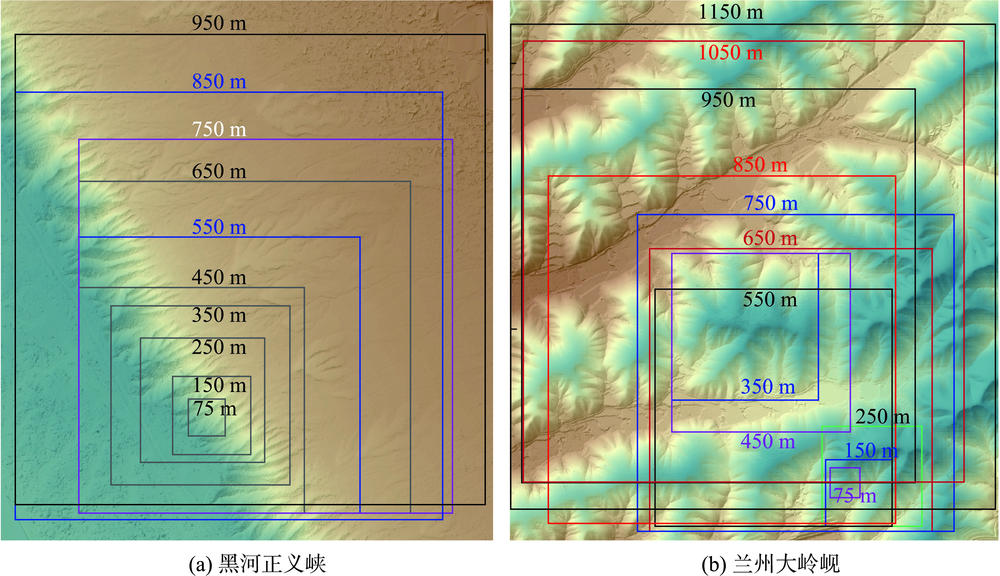
图6 1 m分辨率的不同空间域地形分布范围注:正方形框表示不同空间域地形分布范围。 Fig. 6 The terrain distribution ranges about different areas with 1 m resolution |
| [1] |
|
| [2] |
|
| [3] |
|
| [4] |
|
| [5] |
杨岩岩, 刘连友 . 无定河流域沟谷密度特征及其影响因素分析[J]. 干旱区资源与环境, 2014,28(3):79-85.
[
|
| [6] |
田剑, 汤国安, 周毅 , 等. 黄土高原沟谷密度空间分异特征研究[J]. 地理科学, 2013,33(5):622-628.
[
|
| [7] |
|
| [8] |
江岭, 汤国安, 赵明伟 , 等. 顾及地貌结构特征的黄土沟头提取及分析[J]. 地理研究, 2013,32(11):2153-2162.
[
|
| [9] |
|
| [10] |
|
| [11] |
|
| [12] |
|
| [13] |
|
| [14] |
|
| [15] |
|
| [16] |
汤国安 . 我国数字高程模型与数字地形分析研究进展[J]. 地理学报, 2014,69(9):1305-1325.
[
|
| [17] |
|
| [18] |
|
| [19] |
陈天博, 胡卓玮, 魏铼 , 等. 无人机遥感数据处理与滑坡信息提取[J]. 地球信息科学学报, 2017,19(5):692-701.
[
|
| [20] |
|
| [21] |
|
| [22] |
黄骁力, 汤国安, 刘凯 . DEM分辨率对地形纹理特征提取的影响[J]. 地球信息科学学报. 2015,17(7):822-829.
[
|
| [23] |
安辛克, 李琳琳, 张运刚 . 不同分辨率SRTM-DEM的数字地形分析比较研究[J]. 测绘与空间地理信息, 2010,33(6):73-75.
[
|
| [24] |
贺晓晖, 陈楠 . 从规则格网DEM中提取沟谷网络的方法研究[J]. 遥感信息, 2015,30(1):134-138.
[
|
| [25] |
刘学军, 卢华兴, 仁政 , 等. 论DEM地形分析中的尺度问题[J]. 地理研究, 2007,26(3):433-442.
[
|
| [26] |
杨存建, 赵曦琳, 周其林 , 等. 丘陵地区DEM与坡度的尺度效应分析[J]. 地球信息科学学报. 2013,15(6):814-818.
[
|
| [27] |
王婷婷, 杨昕, 叶娟娟 , 等. 不同尺度DEM的河流裂点提取及其效应分析[J]. 地球信息科学学报, 2014,16(6):882-889.
[
|
| [28] |
郭伟玲, 樊宇, 杨勤科 . 基于不同分辨率DEM提取坡长的统计分布[J]. 水土保持研究, 2019,26(3):72-76.
[
|
| [29] |
陈楠 . 基于信息损失量的坡度精度分析[J]. 地球信息科学学报, 2014,16(6):852-858.
[
|
| [30] |
苑露莎, 郑新奇, 郭继发 . DEM提取沟谷的尺度效应分析:2013全国土地资源开发利用与生态文明建设学术研讨会[C]. 西宁, 2013.
[
|
| [31] |
温振玲, 胡小飞, 潘保田 , 等. 甘肃金塔南山河流阶地褶皱变形分析[J]. 地质论评. 2015,61(5):1032-1046.
[
|
| [32] |
|
| [33] |
|
| [34] |
|
| [35] |
|
| [36] |
|
| [37] |
|
| [38] |
胡洁, 杨勤科, 郭兰勤 . 基于快速傅立叶变换(FFT)的地形剖面线的数学表达研究[J]. 长江科学院院报, 2012,29(5):62-66.
[
|
| [39] |
胡洁 . 基于傅里叶变换的侵蚀地形频率研究——以黄土丘陵区为例[D]. 咸阳:西北农林科技大学, 2012.
[
|
| [40] |
|
| [41] |
|
| [42] |
|
| [43] |
龙恩 . 基于遥感与DEM的长白山区数字地貌制图方法研究[D]. 长春:东北师范大学, 2005.
[
|
| [44] |
段伟, 闫利 . 融合图像的频率定量分析及其空间分辨率的确定方法[J]. 测绘学报. 2016,45(6):691-697.
[
|
| [45] |
|
| [46] |
任沂斌, 陈振杰, 程亮 , 等. 采用动态负载均衡的LiDAR数据生成DEM并行算法[J]. 地球信息科学学报, 2015,17(5):531-537.
[
|
| [47] |
|
| [48] |
|
| [49] |
|
/
| 〈 |
|
〉 |