
Journal of Geo-information Science >
Study on the Delimitation of Urban Growth Boundary based on FLUS Model and Kinetic Energy Theorem
Received date: 2019-07-31
Request revised date: 2020-01-10
Online published: 2020-05-18
Supported by
Natural Science Foundation of Fujian Province(2018J01741)
Key Public Welfare Projects of Science and Technology Department of Fujian Province(2017R1034-2)
Science and Technology Fund of Surveying and Mapping Geographic Information Bureau of Fujian Province(2017JX04)
Copyright
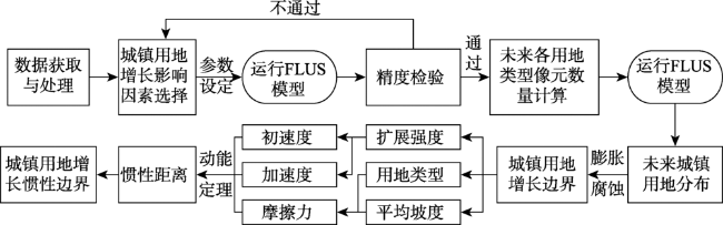
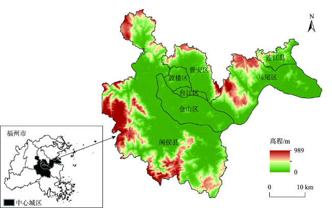
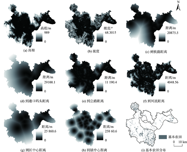
:Delineation of urban growth boundary is an important means to prevent the disorderly spread of urban land, protect the ecological environment of the open space outside the cities, and realize the smart growth of cities, which is of great significance to the healthy and sustainable development of cities. Currently, the studies on urban growth boundary delineation mostly use model method, such as Cellular Automata (CA) model, a relatively mature model, to simulate future urban patterns. However, these studies mostly focuses on the delineation of urban growth boundary. There is little effort on quantitative delineation of the inertia boundary of urban growth. The delineation of inertial boundaries can not only reserve a certain space for urban development, but also improve implementation efficiency in urban planning. Based on this, we proposed a method based on the kinetic energy theorem of the mechanics. The FLUS model and the Morphological Erosion and Dilation method (MED) were used to delineate the urban growth boundary. Slope and land use type were used as the frictional force to delimit the inertial boundary. The FLUS model inherits the Artificial Neural Network (ANN) and the Cellular Automaton(CA) model for simulating and predicting the future urban landscape. The MED was used for the clustering of urban neighborhoods to merge into a single area, while eliminating small but isolated urban plaque. In our paper, we selected Fuzhou, a coastal developed city with obvious changes in recent years, as the study area. We simulated the land use patterns from 2000 to 2015 to verify the accuracy of the model. The overall accuracy of land use simulation in 2015 was 0.9389 and the Kappa coefficient was 0.9165. We further predicted the land use pattern in 2027, and delineated the urban growth boundary and inertia boundary in 2027. Results show that the FLUS model and MED can effectively simulate land use and better fit the growth boundary of urban land use. Using the method of kinetic energy theorem for reference, the inertia boundary of a city can be well delineated according to the expansion resistance in different directions and the expansion intensity in different directions, which provides practical operability and reference values for future study.
HUANG Kang , DAI Wenyuan , HUANG Wangli , OU Hui . Study on the Delimitation of Urban Growth Boundary based on FLUS Model and Kinetic Energy Theorem[J]. Journal of Geo-information Science, 2020 , 22(3) : 557 -567 . DOI: 10.12082/dqxxkx.2020.190415
表1 福州中心城区遥感影像数据信息Tab. 1 Remote sensing image data information of Fuzhou central city |
| 传感器 | 日期 | 轨道号 | 多光谱波段分辨率/m |
|---|---|---|---|
| Landsat-05 | 2000-06-29 | 119/042 | 30 |
| Landsat-08 | 2015-09-27 | 119/042 | 30 |
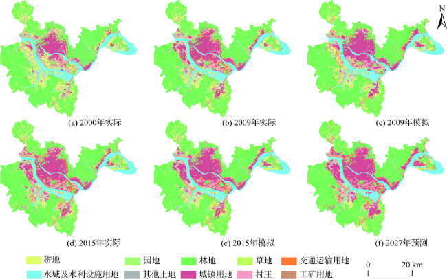
图4 2000—2015年土地利用现状与2009—2027年模拟预测结果Fig. 4 Land use status from 2000 to 2015 and simulation forecast results from 2009 to 2027 |
表2 FLUS模型精度评价Tab. 2 Accuracy evaluation of FLUS model |
| 生产者精度(PA) | Kappa | OA | ||||||||||
|---|---|---|---|---|---|---|---|---|---|---|---|---|
| 年份 | 耕地 | 园地 | 林地 | 草地 | 交通运 输用地 | 水域及水利 设施用地 | 其他 土地 | 城镇 用地 | 村庄 | 工矿 用地 | ||
| 2009 | 0.8048 | 0.9857 | 0.9880 | 0.8706 | 0.2643 | 0.9526 | 0.7508 | 0.7656 | 0.7790 | 0.8911 | 0.8603 | 0.8981 |
| 2015 | 0.8725 | 0.9395 | 0.9917 | 0.9475 | 0.6379 | 0.9698 | 0.8849 | 0.8871 | 0.8695 | 0.9438 | 0.9165 | 0.9389 |
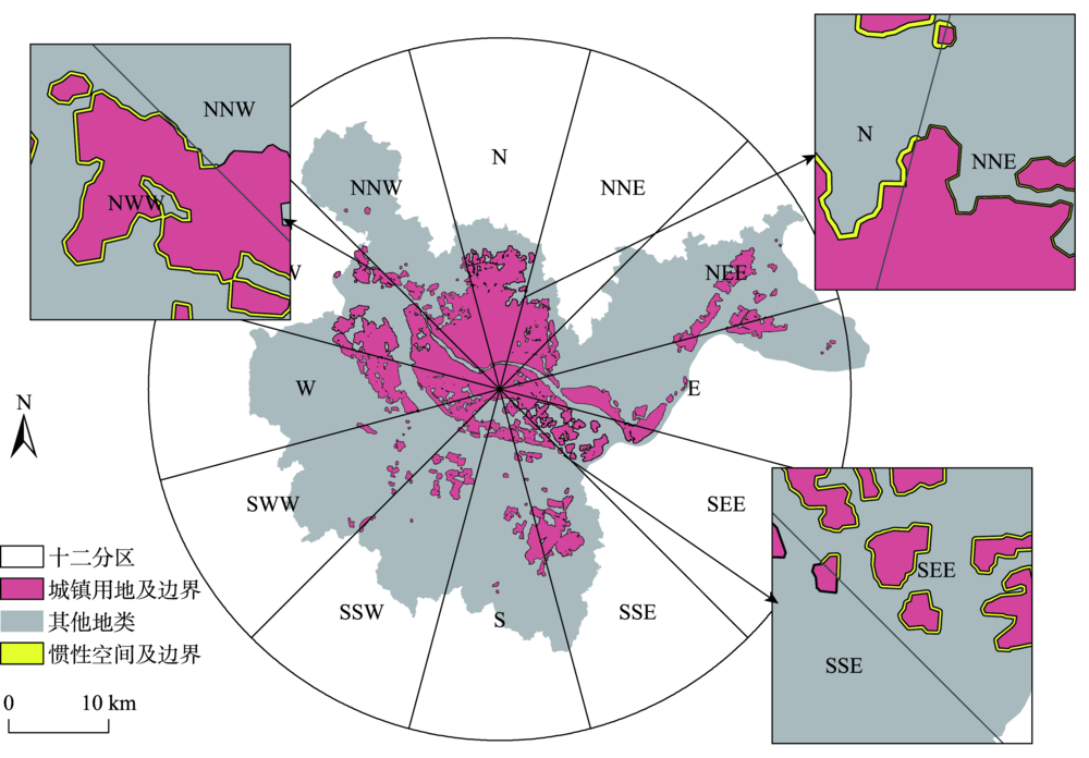
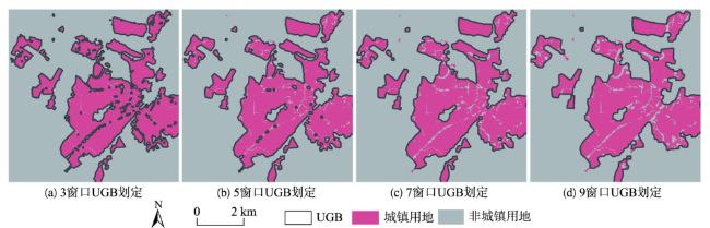
图6 2030年福州中心城区城镇用地增长惯性边界Fig. 6 Urban land growth inertia boundary in Fuzhou central city in 2030 |
表3 各方向参数(速度、加速度、坡度和摩擦系数)及惯性距离Tab. 3 Parameters (speed, acceleration, slope and friction coefficient) and inertia distance in all directions |
| 方向 | N | NNE | NEE | E | SEE | SSE | S | SSW | SWW | W | NWW | NNW |
|---|---|---|---|---|---|---|---|---|---|---|---|---|
| v1(km/a) | 2.99×10⁻³ | 6.71×10⁻³ | 2.07×10⁻² | 2.59×10⁻³ | 7.26×10⁻³ | 3.22×10⁻³ | 2.28×10⁻³ | 3.89×10⁻³ | 2.32×10⁻³ | 3.47×10⁻³ | 3.12×10⁻³ | 1.62×10⁻³ |
| v2(km/a) | 4.93×10⁻³ | 3.46×10⁻³ | 2.38×10⁻³ | 1.95×10⁻³ | 4.89×10⁻³ | 5.28×10⁻³ | 1.56×10⁻³ | 2.15×10⁻³ | 1.07×10⁻³ | 1.75×10⁻³ | 4.22×10⁻³ | 1.06×10⁻³ |
| a(km/a2) | 1.61×10⁻⁴ | 2.71×10⁻⁴ | 2.62×10⁻⁵ | 5.29×10⁻⁵ | 1.98×10⁻⁴ | 1.72×10⁻⁴ | 6.01×10⁻⁵ | 1.45×10⁻⁴ | 1.04×10⁻⁴ | 1.43×10⁻⁴ | 9.17×10⁻⁵ | 4.69×10⁻⁵ |
| 平均坡度/% | 100.0438 | 118.8172 | 205.8168 | 105.0857 | 16.2596 | 96.9632 | 210.7418 | 203.8767 | 225.3412 | 317.7963 | 40.3332 | 214.0893 |
| 坡度摩擦系数 | 0.0539 | 0.0640 | 0.1109 | 0.0566 | 0.0088 | 0.0523 | 0.1136 | 0.1099 | 0.1215 | 0.1713 | 0.0217 | 0.1154 |
| 用地摩擦系数 | 3.7742 | 2.8323 | 30.4088 | 18.4963 | 2.8350 | 12.1389 | 20.7054 | 18.5137 | 19.1656 | 21.5786 | 6.8599 | 21.1438 |
| 总摩擦系数 | 1.9140 | 1.4482 | 15.2599 | 9.2765 | 1.4219 | 6.0956 | 10.4095 | 9.3118 | 9.6435 | 10.8750 | 3.4408 | 10.6296 |
| 惯性距离/m | 39.3777 | 15.2297 | 7.1216 | 3.8815 | 42.4928 | 13.2985 | 1.9418 | 1.7098 | 0.5755 | 0.9841 | 28.2787 | 1.1188 |
注:坡度摩擦系数由平均坡度进行标准化求得;用地摩擦系数由各地类面积与其赋值标准化乘积求和所得;总摩擦系数为坡度摩擦系数等权求和所得。 |
| [1] |
刘志玲, 李江风, 龚健 . 城市空间扩展与“精明增长”中国化[J]. 城市问题, 2006(5):17-20.
[
|
| [2] |
周艳, 黄贤金, 徐国良 , 等. 长三角城市土地扩张与人口增长耦合态势及其驱动机制[J]. 地理研究, 2016,35(2):313-324.
[
|
| [3] |
[
|
| [4] |
丁成日. 世界巨(特)大城市发展:规律、挑战、增长控制及其评价[M]. 北京: 中国建筑工业出版社, 2015.
[
|
| [5] |
洪世键, 张京祥 . 城市蔓延机理与治理[M]. 南京: 东南大学出版社, 2012.
[
|
| [6] |
《城市规划编制办法》, 中华人民共和国建设部,第146号, 2006.
[ Urban Planning Formulation Means, order of the Ministry of construction of the people's Republic of China, No. 46, 2006. ]
|
| [7] |
|
| [8] |
吴欣昕, 刘小平, 梁迅 , 等. FLUS-UGB多情景模拟的珠江三角洲城市增长边界划定[J]. 地球信息科学学报, 2018,20(4):532-542.
[
|
| [9] |
|
| [10] |
周锐, 王新军, 苏海龙 , 等. 基于生态安全格局的城市增长边界划定——以平顶山新区为例[J]. 城市规划学刊, 2014(4):57-63.
[
|
| [11] |
刘焱序, 彭建, 孙茂龙 , 等. 基于生态适宜与风险控制的城市新区增长边界划定——以济宁市太白湖新区为例[J]. 应用生态学报, 2016,27(8):2605-2613.
[
|
| [12] |
付玲, 胡业翠, 郑新奇 . 基于BP神经网络的城市增长边界预测——以北京市为例[J]. 中国土地科学, 2016,30(2):22-30.
[
|
| [13] |
苏伟忠, 杨桂山, 陈爽 , 等. 城市增长边界分析方法研究——以长江三角洲常州市为例[J]. 自然资源学报, 2012,27(2):322-331.
[
|
| [14] |
朱寿红, 舒帮荣, 马晓冬 , 等. 基于“反规划”理念及FLUS模型的城镇用地增长边界划定研究——以徐州市贾汪区为例[J]. 地理与地理信息科学, 2017,33(5):80-86,127.
[
|
| [15] |
何春阳, 陈晋, 史培军 , 等. 基于CA的城市空间动态模型研究[J]. 地球科学进展, 2002,17(2):186-195.
[
|
| [16] |
陈宝芬, 张耀民, 江东 . 基于CA-ABM模型的福州城市用地扩张研究[J]. 地理科学进展, 2017,36(5):626-634.
[
|
| [17] |
|
| [18] |
李效顺, 魏旭晨, 郎文婧 , 等. 基于地价均衡的城市扩张理论命题与调控策略研究[J]. 中国土地科学, 2018,32(3):6-13.
[
|
| [19] |
|
| [20] |
|
| [21] |
张丁轩, 付梅臣, 陶金 , 等. 基于CLUE-S模型的矿业城市土地利用变化情景模拟[J]. 农业工程学报, 2013,29(12):246-256,294.
[
|
| [22] |
|
| [23] |
《福州市城市总体规划(2011-2020年)》, 福州市人民政府, 2015.
[ Fuzhou City Master Plan (2011-2020), Fuzhou Municipal People's government, 2015. ]
|
| [24] |
全泉, 田光进, 沙默泉 . 基于多智能体与元胞自动机的上海城市扩展动态模拟[J]. 生态学报, 2011,31(10):2875-2887.
[
|
| [25] |
姜博, 王媛, 魏超 , 等. 城市土地利用扩展的驱动因素与空间扩展模式研究[J]. 干旱区资源与环境, 2014,28(7):1-6.
[
|
| [26] |
龚健, 陈耀霖, 张志 . 基于多分类Logistic回归模型的区域土地利用变化及驱动因素研究[J]. 湖北农业科学, 2016,55(17):4545-4550.
[
|
| [27] |
张大川, 刘小平, 姚尧 , 等. 基于随机森林CA的东莞市多类土地利用变化模拟[J]. 地理与地理信息科学, 2016,32(5):29-36,127.
[
|
| [28] |
《城市用地竖向规划规范》(CJJ 83-99). 中华人民共和国建设部, 1999.
[ Code for Vertical Planning on Urban Field(CJJ 83-99), Ministry of Construction of the People's Republic of China, 1999. ]
|
/
| 〈 |
|
〉 |
