
Journal of Geo-information Science >
Demarcating of Permanent Prime Farmland for Synergy of Farmland Protection and Urban Expansion: A Case Study of Wuhan
Received date: 2019-07-31
Request revised date: 2019-12-10
Online published: 2020-05-18
Supported by
National Natural Science Foundation of China(41371113)
Science Foundation of Ministry of Education of China(18JHQ081)
China Postdoctoral Science Foundation(2015M572173)
Fundamental Research Funds for the Central Universities(2662017PY063)
Copyright
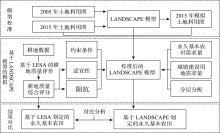
Demarcating permanent prime farmland is an effective way to realize farmland protection, intensive land use and food security. With the challenging of rapid urban expansion, the completion between urban expansion and farmland protection is unavoidable. It is urgent to reasonably demarcating permanent prime farmland by synergizing farmland protection and urban expansion. In view of this conflict, taking Wuhan as an example, this paper carries out the demarcation of permanent prime farmland by using LESA (Land Evaluation and Site Assessment) method and LANDSCAPE ( LAND System Cellular Automata model for Potential Effects) model, attempting to achieve balanced development of urban expansion and farmland protection, which provides reference for scientific demarcation of permanent prime farmland under the background of multiplanning integration, and provides support for prime farmland protection and optimizing of land allocation. Firstly, comprehensive evaluation and classification of farmland in Wuhan is carried out through LESA, then based on this result, simulation of demarcation of permanent prime farmland and urban expansion is carried out through LANDSCAPE model, at last, the results of the two methods are compared in quantity, quality and spatial patterns. The results show that permanent prime farmlands demarcated in two methods have little difference in quantity and quality. The area of permanent prime farmland demarcated by LESA method is 243 259 hm 2, 45.63% of which land fertility grade of cultivated land is between grade 1 and grade 3. The area of permanent prime farmland demarcated by LANDSCAPE model is 243 200 hm 2, 45.77% of which land fertility grade of cultivated land is between grade 1 and grade 3. There are more than 80% of the permanent prime farmland that land fertility grade is between grade 1 and grade 5 in both methods, which shows that the total quality of permanent prime farmland is good in either method. However, the result of LANDSCAPE model is better in spatial patterns, which permanent prime farmland demarcated by LANDSCAPE model distributes concentrated and is regular in shape. It's remarkable that 15.8% of permanent prime farmlands demarcated by LESA are overlapped by urban constructive land in the processing of urban expansion, which has been effectively avoided by LANDSCAPE model. The possible cause of this conflict are as follows: (1) The permanent prime farmland demarcated by LESA method is based on ranking of integrated score, in which the requirements for concentrated fragmentation and shape index of permanent prime farmland are not considered; (2) The conflict of farmland protection and urban expansion is not considered in LESA method.
HUANG Hui , KE Xinli . Demarcating of Permanent Prime Farmland for Synergy of Farmland Protection and Urban Expansion: A Case Study of Wuhan[J]. Journal of Geo-information Science, 2020 , 22(3) : 592 -604 . DOI: 10.12082/dqxxkx.2020.190414
表1 武汉市耕地划入永久基本农田的指标、赋值方法及权重Tab. 1 Indexes, assessment methods and weights of permanent prime farmland demarcation in Wuhan City |
| LESA体系 | 一级指标 | 二级指标 | 指标赋值标准 | 权重 | ||||
|---|---|---|---|---|---|---|---|---|
| 100 | 80 | 60 | 40 | 20 | ||||
| 耕地质量(LE) | 土壤条件 | 有机质含量 | 27.10~30.79 | 24.90~27.1 | 23.00~24.90 | 20.90~23.00 | 16.70~20.90 | 0.19 |
| 表层质地 | 壤土 | 粘壤土 | 粘土 | 砂土 | 0.15 | |||
| pH值 | 6.5~7.5 | 5.5~6.5 7.5~8.0 | 5.0~5.5 | 4.5~5.0 | 0.11 | |||
| 地形条件 | 坡度 | <2 | 2~10 | 10~25 | ≥25 | 0.12 | ||
| 高程 | <31.19 | 31.19~47.69 | 47.69~76.57 | 76.57~161.15 | >161.15 | 0.08 | ||
| 基础设施条件 | 灌溉条件 | 充分满足 | 基本满足 | 不满足 | 0.20 | |||
| 排水条件 | 充分满足 | 基本满足 | 不满足 | 0.15 | ||||
| 立地条件(SA) | 区位条件 | 到主干道距离/km | ≤0.5 | 0.5~1.0 | 1.0~1.5 | 1.5~2.0 | >2.0 | 0.19 |
| 到水源距离/km | ≤0.5 | 0.5~1.0 | 1.0~1.5 | 1.5~2.0 | >2.0 | 0.18 | ||
| 到居民点距离/km | ≤0.2 | 0.2~0.5 | 0.5~0.8 | 0.8~1.2 | >1.2 | 0.23 | ||
| 空间形态 | 连片度 | P=100(Si-Smin)/(Smax-Smin) | 0.16 | |||||
| 形状指数 | E=100(Ei-Emin)/(Emax-Emin) | 0.24 | ||||||
表2 武汉市耕地LESA综合分值统计及分级Tab. 2 LESA comprehensive score statistics and classification of farmland in Wuhan |
| 耕地等级 | LESA综合分值/分 | 耕地面积/km2 | 比例/% |
|---|---|---|---|
| I | >75 | 278.40 | 5.45 |
| II | 65~75 | 1699.32 | 33.29 |
| III | 55~65 | 2161.47 | 42.35 |
| IV | 45~55 | 874.77 | 17.14 |
| V | <45 | 90.16 | 1.77 |
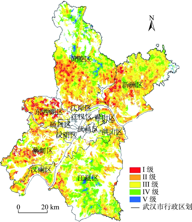
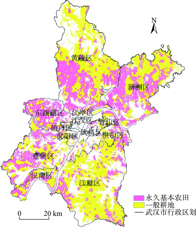
图5 武汉市永久基本农田划定基础Fig. 5 Basic map for permanent prime farmland demarcation in Wuhan |
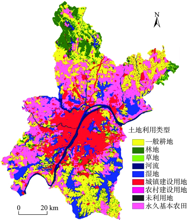
图6 基于LANDSCAPE的武汉市永久基本农田Fig. 6 Permanent prime farmland demarcation in Wuhan based on LANDSCAPE model |
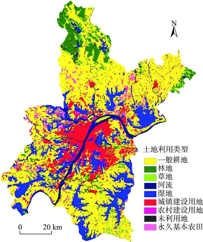
表3 武汉市永久基本农田划定模拟结果Tab. 3 Results of permanent prime farmland demarcation simulation in Wuhan (hm2) |
| 地类 | 一般耕地 | 林地 | 草地 | 河流 | 湿地 | 城镇建设用地 | 农村建设用地 | 未利用地 | 永久基本农田 |
|---|---|---|---|---|---|---|---|---|---|
| 面积 | 197 509 | 70 359 | 4995 | 28 472 | 129 843 | 160 000 | 21 252 | 256 | 243 200 |
| 城市扩张占用面积 | 19 372 | 6873 | 2928 | 0 | 26 373 | - | 4 181 | 344 | 0 |
| 新划入的永久基本农田面积 | 215 360 | 0 | 0 | 0 | 0 | 0 | 0 | 0 | - |
表4 2种方法划定的永久基本农田耕地地力等级对比Tab. 4 Comparison of quality grade of permanent prime farmland demarcated based on two methods |
| 县域耕地地力等级 | LESA方法划定 | LANDSCAPE方法划定 | |||
|---|---|---|---|---|---|
| 农田面积/hm2 | 比例/% | 农田面积/hm2 | 比例/% | ||
| 1 | 46 515 | 22.67 | 45 157 | 22.58 | |
| 2 | 21 464 | 10.46 | 21 189 | 10.59 | |
| 3 | 25 622 | 12.49 | 25 194 | 12.60 | |
| 4 | 40 367 | 19.68 | 36 453 | 18.22 | |
| 5 | 35 544 | 17.33 | 34 483 | 17.24 | |
表5 2种方法划定的永久基本农田景观指数对比Tab. 5 Comparison of landscape index of permanent prime farmland demarcated based on two methods |
| 永久基本农田划分方法 | 斑块数量/个 | 平均斑块面积/hm2 | 破碎度 | 平均斑块分维数 | 面积加权平均形状因子 |
|---|---|---|---|---|---|
| LESA | 3072 | 156.12 | 1.2566E-06 | 1.2845 | 1.2180 |
| LANDSCAPE | 1457 | 317.66 | 5.9885E-07 | 1.2473 | 1.1540 |
| [1] |
钱凤魁, 王秋兵, 边振兴 , 等. 永久基本农田划定和保护理论探讨[J]. 中国农业资源与区划, 2013,34(3):22-27.
[
|
| [2] |
邵一希 . 基于LESA体系的永久基本农田划定方法研究——以上海为例[J]. 上海国土资源, 2017,38(2):87-90.
[
|
| [3] |
钱凤魁, 王秋兵 . 基于农用地分等和LESA 方法的基本农田划定[J]. 水土保持研究, 2011,18(3):251-255.
[
|
| [4] |
董秀茹, 尤明英, 王秋兵 . 基于土地评价的基本农田划定方法[J]. 农业工程学报, 2011,27(4):336-339.
[
|
| [5] |
杨绪红, 金晓斌, 贾培宏 , 等. 多规合一视角下县域永久基本农田划定方法与实证研究[J]. 农业工程学报, 2019,35(2):250-259.
[
|
| [6] |
钱鑫, 樊宏, 高燕 , 等. 基于GIS 技术的基本农田保护研究——以成都市龙泉驿区为例[J]. 国土资源科技, 2006(6):81-82.
[
|
| [7] |
李赓, 吴次芳, 曹顺爱 . 划定基本农田指标体系的研究[J]. 农机化研究, 2006,8:46-48.
[
|
| [8] |
郧文聚 . 农用地分等及其应用研究[D]. 北京:中国农业大学, 2005.
[
|
| [9] |
郑新奇, 杨树佳, 象伟宁 , 等. 基于农用地分等的基本农田保护空间规划方法研究[J]. 农业工程学报, 2007,23(1):66-71.
[
|
| [10] |
闫宁, 郑宏刚 . 农用地分等在基本农田划分中的应用研究[J]. 国土与自然资源研究, 2009(3):28-30.
[
|
| [11] |
姜广辉, 张瑞娟, 张翠玉 , 等. 基于空间集聚格局和边界修正的基本农田保护区划定方法[J]. 农业工程学报, 2015,31(23):222-229.
[
|
| [12] |
任艳敏, 唐秀美, 刘玉 , 等. 考虑耕地生态质量的基本农田划定方法[J]. 农业工程学报, 2014,30(24):298-307.
[
|
| [13] |
赵素霞, 牛海鹏, 张捍卫 , 等. 基于生态位模型的高标准基本农田建设适宜性评价[J]. 农业工程学报, 2016,32(12):220-228.
[
|
| [14] |
王森, 李丽 . 有关美国土地与基础设施评估方法的研究[J]. 水土保持科技情报, 2004(1):11-13.
[
|
| [15] |
秦志锋, 秦明周, 秦玉霞 . 美国土地评价与立地分析(LESA)系统研究[J]. 三门峡职业技术学院学报, 2007,6(4):96-98.
[
|
| [16] |
边振兴, 刘琳琳, 王秋兵 , 等. 基于LESA的城市边缘区永久基本农田划定研究[J]. 资源科学, 2015,37(11):2172-2178.
[
|
| [17] |
陈茜 . 组团式城市永久基本农田的全域规划及其功能研究——以重庆市北碚区为例[D]. 重庆:西南大学, 2017.
[
|
| [18] |
宋具兰 . 贵州县域尺度高标准基本农田建设时序与模式研究[D]. 贵阳:贵州大学, 2017.
[
|
| [19] |
白佳宜, 张裕凤 . 县域永久基本农田划定研究——以内蒙古自治区土默特左旗为例[J]. 内蒙古师范大学学报(自然科学汉文版), 2019,48(1):63-68.
[
|
| [20] |
边振兴, 杨子娇, 钱凤魁 , 等. 基于LESA体系的高标准基本农田建设时序研究[J]. 自然资源学报, 2016,31(3):436-446.
[
|
| [21] |
吴飞, 濮励杰, 许艳 , 等. 耕地入选基本农田评价与决策[J]. 农业工程学报, 2009,25(12):270-277.
[
|
| [22] |
钱凤魁 . 基于耕地质量及其立地条件评价体系的基本农田划定研究[D]. 沈阳:沈阳农业大学, 2011.
[
|
| [23] |
程雄, 吴争研, 刘艳芳 . GIS技术在基本农田保护工作中的应用[J]. 国土资源信息化, 2002(4):37-39.
[
|
| [24] |
罗志军, 赵越, 赵杰 , 等. 基于景观格局与空间自相关的永久基本农田划定研究[J]. 农业机械学报, 2018,49(10):195-204.
[
|
| [25] |
聂艳, 吴西子, 于婧 , 等. 基于土地评价和空间聚类的基本农田划定方法研究——以湖北省鹤峰县为例[J]. 中国土地科学, 2013,27(12):39-45.
[
|
| [26] |
朱美青, 黄宏胜, 史文娇 , 等. 基于多规合一的基本农田划定研究——以江西省余江县为例[J]. 自然资源学报, 2016,31(12):2111-2121.
[
|
| [27] |
叶英聪, 孙凯, 匡丽花 , 等. 基于空间决策的城镇空间与农业生产空间协调布局优化[J]. 农业工程学报, 2017,33(16):256-266.
[
|
| [28] |
冉娜, 金晓斌, 范业婷 , 等. 基于土地利用冲突识别与协调的“三线”划定方法研究:以常州市金坛区为例[J]. 资源科学, 2018,40(2):284-98.
[
|
| [29] |
|
| [30] |
武汉市统计局. 2018武汉统计年鉴[M]. 武汉:武汉统计年鉴, 2018.
[ Wuhan Statistical Bureau. Wuhan Statistical Yearbook 2018[M]. Wuhan: Wuhan Statistical Yearbook, 2018. ]
|
| [31] |
湖北省人民政府. 武汉市城市周边永久基本农田划定工作圆满完成[DB/OL]. http://www.hubei.gov.cn/zwgk/zdlyxxgk/ggzy/zdhfwzs/zsdt/201608/t20160811_880675.shtml.2016-08-11.
[ Hubei Provincial People's Government. The delimitation of permanent basic farmland around Wuhan City has been successfully completed[DB/OL]. http://www.hubei.gov.cn/zwgk/zdlyxxgk/ggzy/zdhfwzs/zsdt/201608/t20160811_880675.shtml.2016-08-11. ]
|
| [32] |
|
| [33] |
柯新利, 郑伟伟, 杨柏寒 . 权衡城市扩张、耕地保护与生态保育的土地利用布局优化——以武汉市为例[J]. 地理与地理信息科学, 2016, 32(5):9-13,51,2.
[
|
| [34] |
胡飞, 柯新利, 柴明 , 等. 权衡城市扩张与永久基本农田保护的城市增长边界划定——以武汉市为例[J]. 地理与地理信息科学, 2019,35(3):72-77.
[
|
| [35] |
|
| [36] |
吴欣昕, 刘小平, 梁迅 , 等. FLUS-UGB多情景模拟的珠江三角洲城市增长边界划定[J]. 地球信息科学学报, 2018,20(4):532-542.
[
|
| [37] |
胡业翠, 付玲, 李琦 . 北京城市增长边界预测[J]. 地球信息科学学报, 2017,19(4):486-492.
[
|
| [38] |
武汉市国土资源与规划局. 武汉市土地利用总体规划(2006-2020)[DB/OL]. http://www.wpl.gov.cn/pc-871-78165.html.2015-12-30.
[ Wuhan Bureau of Land and Resources and Planning. General Planning of Land Use in Wuhan(2006-2020)[DB/OL]. http://www.wpl.gov.cn/pc-871-78165.html.2015-12-30. ]
|
| [39] |
傅伯杰, 陈利顶, 马克明 , 等. 景观生态学原理及应用[M]. 北京: 科学出版社, 2001.
[
|
| [40] |
中国土壤数据库. 湖北省土壤资源数据集[DB/OL]. URL: http://vdb3.soil.csdb.cn/.
[ Soil Science Database. Soil resource data set of Hubei Province[DB/OL]. URL: http://vdb3.soil.csdb.cn/. ]
|
| [41] |
美国航空航天局. 航空雷达测绘数据STRM1 DEM)[DB/OL]. URL: https://www.nasa.gov/.
[ National Aeronautics and Space Administration. Shuttle Radar Topography Missiong (STRM1 DEM).[DB/OL].] URL: https://www.nasa.gov/. ]
|
| [42] |
贾振, 韩印 . 基于百度地图API的智能交通信息展示[J]. 物流工程与管理, 2016,38(7):211-213.
[
|
| [43] |
美国地质勘探局. Landsat 8 OLI_TIRS影像数据[DB/OL]. URL: https://earthexplorer.usgs.gov/.
[ United States Geological Survey. Image data from Landsat 8 OLI_TIRS[DB/OL].] URL: https://earthexplorer.usgs.gov/. ]
|
| [44] |
中国科学院资源环境科学数据中心. 2005年中国土地利用现状遥感监测数据[DB/OL]. URL: http://www.resdc.cn/.
[ Resource and Environment Data Cloud Platform. Remote sensing monitoring data of land use in China, 2005[DB/OL].] URL: http://www.resdc.cn/. ]
|
/
| 〈 |
|
〉 |