
Journal of Geo-information Science >
Spatiotemporal Model Analysis of Land Change Process based on Nearest Spatiotemporal Distance
Received date: 2019-09-30
Request revised date: 2019-12-27
Online published: 2020-05-18
Supported by
National Natural Science Foundation of China(41602173)
National Natural Science Foundation of China(41771188)
National Natural Science Foundation of Anhui(1908085QD164)
Natural Science Research Project of Anhui Higher Education Institutions(KJ2019A0046)
Science and Technology Project of Department of Land and Resources of Anhui Province(2016-K-12)
Copyright
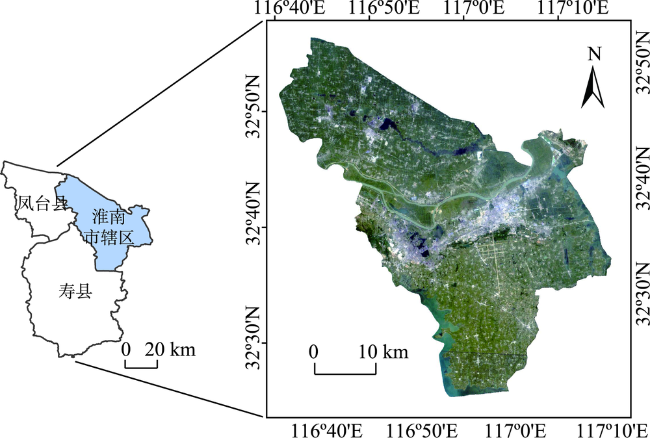
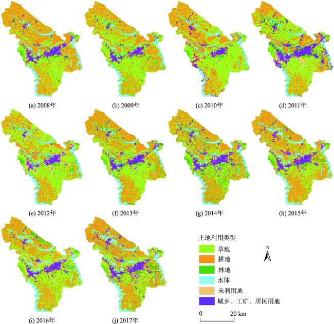
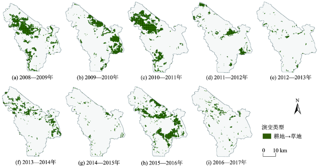
Due to human activities and rapid urban expansion, land use/land cover has changed dramatically. The change has a great impact on the ecological environment and surface landscape. The change process of land use and cover change is not only affected by various factors such as nature and economy, but also an external representation restricted by the laws of human activities and natural factors. Therefore, it is of vital significance to study the change process of land use and land cover. For the monitoring and analysis of land use and cover change, the traditional method focuses on the study of the overall differences in land use structure in each spatiotemporal snapshot. This method cuts off the organic connection of land use units in the evolution process between different snapshots. Traditional research has the phenomenon of paying attention to pattern but neglecting process and emphasizing simulation but despising measurement. This paper takes the land change process composed of serial land use data as the core research object. The advantage of this is that the relevant land evolution units at different time snapshots can be considered as a unified whole. On this basis, this paper chooses the nearest spatiotemporal distance to measure the spatiotemporal agglomeration of the land use change process. First, through multiple experiments, the appropriate space-time grid was selected to segment the land use/land cover data in the study area. Secondly, based on the analysis, the typical land use change process was extracted. And then, for the land use change process object on the space-time cube, calculate the average nearest-neighbor spatiotemporal distance. The distance is compared with the distance value in the random mode based on Monte Carlo simulation, so as to judge the spatiotemporal aggregation of the land use change process in the study area. Finally, the results were tested for statistical significance. The land use data of Huainan mining area from 2008 to 2017 was used for empirical research. The land use evolution process from cultivated land to grassland in any two years was selected as a typical spatiotemporal evolution type. The results show that this type of land change in the study area has exhibited a spatiotemporal aggregation pattern in the past 10 years, but the pattern is not statistically significant. The research in this paper is helpful for grasping the evolution process of land use units in space and time, and to explore the potential spatiotemporal evolution patterns in the process of land use change.
NIE Pin , LIANG Ming , LI Yujie , YOU Xinyan , SUN Xiaojuan . Spatiotemporal Model Analysis of Land Change Process based on Nearest Spatiotemporal Distance[J]. Journal of Geo-information Science, 2020 , 22(3) : 628 -637 . DOI: 10.12082/dqxxkx.2020.190569
表1 时空随机模式的显著性评价标准Tab. 1 Significance evaluation criteria of spatiotemporal random models |
| p值(概率) | 置信度/% | 显著性 | |
|---|---|---|---|
| >-1.65且<1.65 | — | — | 不显著 |
| <-1.65或>1.65 | <0.10 | 90 | 显著 |
| <-1.96或>1.96 | <0.05 | 95 | 显著 |
| <-2.58或>2.58 | <0.01 | 99 | 显著 |
表2 蒙特卡洛模拟实验与显著性评价实验结果Tab. 2 Experimental results of Monte Carlo simulation experiment and significance evaluation |
| 最邻近指数 | 值 | 时空分布模式类型 | 显著性评价 |
|---|---|---|---|
| 0.343 | 0.920 | 时空聚集模式 | 统计上不显著 |
| [1] |
|
| [2] |
|
| [3] |
宋晓阳, 黄耀欢, 董东林 , 等. 融合数字表面模型的无人机遥感影像城市土地利用分类[J]. 地球信息科学学报, 2018,20(5):703-711.
[
|
| [4] |
|
| [5] |
戴尔阜, 马良 . 土地变化模型方法综述[J]. 地理科学进展, 2018,37(1):152-162.
[
|
| [6] |
李寅超, 李建松 . 基于过程对象的地表覆盖变化时空过程表达模型[J]. 吉林大学学报(地球科学版), 2017,47(3):916-924.
[
|
| [7] |
|
| [8] |
刘淑燕, 余新晓, 李庆云 , 等. 基于CA-Markov模型的黄土丘陵区土地利用变化[J]. 农业工程学报, 2010,26(11):297-303.
[
|
| [9] |
李少英, 刘小平, 黎夏 , 等. 土地利用变化模拟模型及应用研究进展[J]. 遥感学报, 2017,21(3):329-340.
[
|
| [10] |
|
| [11] |
|
| [12] |
|
| [13] |
|
| [14] |
|
| [15] |
徐枫, 陈袁芳, 蔡建南 , 等. 基于点过程模拟的时空级联模式统计挖掘方法[J]. 中南大学学报(自然科学版), 2017,48(10):2717-2724.
[
|
| [16] |
|
| [17] |
|
| [18] |
|
| [19] |
|
| [20] |
|
| [21] |
孙云华, 郭涛, 崔希民 , 等. 基于行为聚类算法的土地利用聚类适宜性分析研究[J]. 地球信息科学学报, 2016,18(3):396-405.
[
|
| [22] |
|
| [23] |
周成虎, 李婷, 裴韬 . 时空点过程:一种新的地学数据模型、分析方法和观察视角[J]. 地球信息科学学报, 2013,15(6):793-800.
[
|
| [24] |
王国杰, 廖善刚 . 土地利用强度变化的空间异质性研究[J]. 应用生态学报, 2006,17(4):611-614.
[
|
| [25] |
|
| [26] |
|
| [27] |
|
| [28] |
|
| [29] |
郑优男, 王晓辉, 彭书传 . 基于RS与GIS技术分析淮南矿区土地利用变化[J]. 环境工程, 2015,33(S1):764-768.
[
|
| [30] |
黄家政, 赵萍, 郑刘根, 周淑媛 . 淮南矿区土地利用/覆盖时空变化特征及预测[J]. 合肥工业大学学报(自然科学版), 2014,37(8):981-986.
[
|
| [31] |
秦云 . 基于SWAT模型的梁子湖流域非点源污染分析[D]. 武汉:湖北大学, 2017.
[
|
| [32] |
许昱堃, 陈广洲, 尤朝辉 , 等. 淮南市2001-2015年可持续发展研究——基于改进的生态足迹模型[J]. 安徽建筑大学学报, 2019,27(2):55-62.
[
|
| [33] |
杨显明, 焦华富, 许吉黎 . 煤炭资源型城市空间结构演化过程、模式及影响因素——基于淮南市的实证研究[J]. 地理研究, 2015,35(10):1256-1264.
[
|
/
| 〈 |
|
〉 |
