
Journal of Geo-information Science >
Mapping Impervious Surface Dynamics of Guangzhou Downtown based on Google Earth Engine
Received date: 2019-01-25
Request revised date: 2019-07-22
Online published: 2020-05-18
Supported by
National Key R&D Program of China(2017YFA0604404)
National Natural Science Foundation of China(41671398)
National Natural Science Foundation of China(41871318)
Copyright
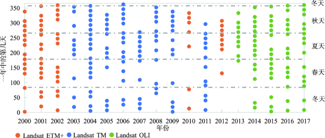
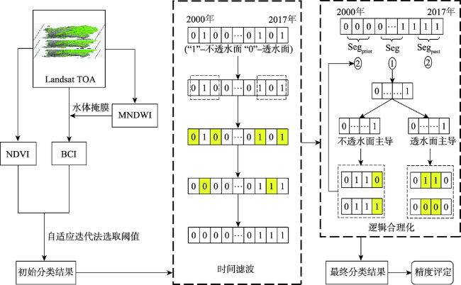
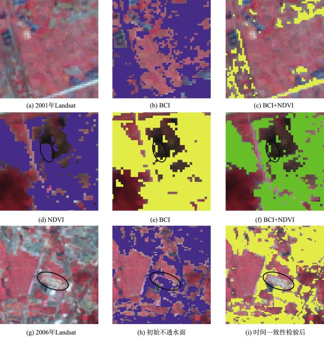
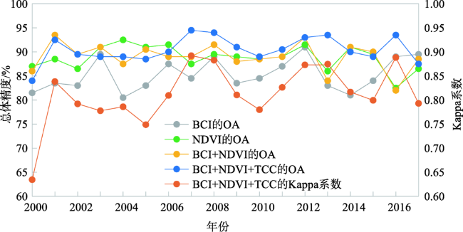
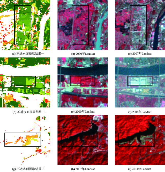
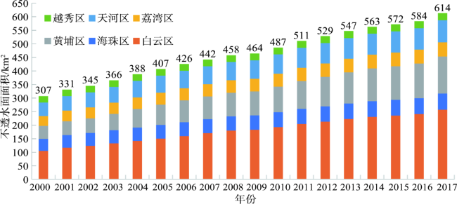
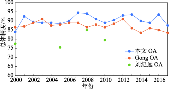
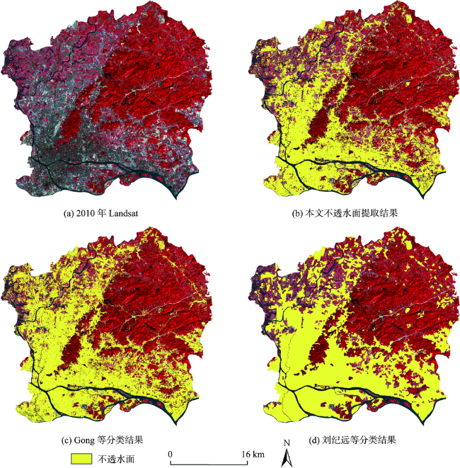
For assessing urbanization level and urban environment, the mapping of impervious surface has become a research hotspot. Compared with single-phase imagery, time series mapping can depict temporal trends, which is of great significance for monitoring urban expansion. Based on the Google Earth Engine platform, this paper calculated BCI and NDVI using Landsat TOA data from 2000 to 2017, and determined their thresholds by an adaptive iteration method to extract the initial impervious surface. Then, Temporal Consistency Check (TCC) was performed to make the time series of impervious surface more reasonable. Results show that: (1) Adding NDVI to both BCI and TCC improved the quality of impervious surface mapping. (2) The average accuracy of impervious surface mapping in this paper was 90.4%, and the average Kappa coefficient was 0.812. (3) The impervious surface area of Guangzhou downtown nearly doubled from 2000 to 2017 with a decreasing growth rate. (4)The newly developed impervious surface mainly concentrated on the relatively backward outskirts of Guangzhou downtown. (5) Elevation, road density, and shopping mart density were the main factors influencing the expansion of impervious surface.

LI Peilin , LIU Xiaoping , HUANG Yinghuai , ZHANG Honghui . Mapping Impervious Surface Dynamics of Guangzhou Downtown based on Google Earth Engine[J]. Journal of Geo-information Science, 2020 , 22(3) : 638 -648 . DOI: 10.12082/dqxxkx.2020.190047
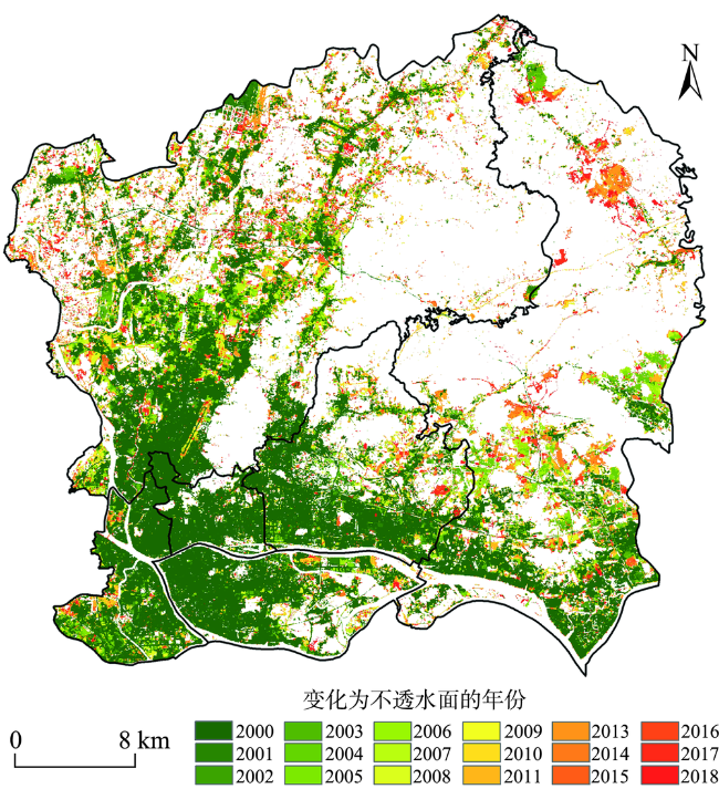
图5 2000—2017年广州市主城区不透水面提取结果Fig. 5 Mapping results of the impervious surface in Guangzhou downtown from 2000 to 2017 |
表1 各影响因子对不透水面扩张的作用Tab. 1 Effect of various factors on the impervious surface expansion |
| 类别 | 自变量 | q值 |
|---|---|---|
| 自然环境因子 | 高程 | 0.2432 |
| 坡度 | 0.1602 | |
| 到水体的距离 | 0.0044 | |
| 交通因子 | 道路密度 | 0.1918 |
| 到地铁站的距离 | 0.0601 | |
| 到公交站的距离 | 0.1591 | |
| 服务设施因子 | 购物场所密度 | 0.1785 |
| 餐饮场所密度 | 0.1371 | |
| 医疗机构密度 | 0.1165 | |
| 学校密度 | 0.1282 |
| [1] |
|
| [2] |
|
| [3] |
|
| [4] |
|
| [5] |
徐涵秋, 王美雅 . 地表不透水面信息遥感的主要方法分析[J]. 遥感学报, 2016,20(5):1270-1289.
[
|
| [6] |
|
| [7] |
|
| [8] |
向超, 朱翔, 胡德勇 , 等. 近20年京津唐地区不透水面变化的遥感监测[J]. 地球信息科学学报. 2018,20(5):684-693.
[
|
| [9] |
|
| [10] |
|
| [11] |
|
| [12] |
|
| [13] |
|
| [14] |
|
| [15] |
王燕燕, 于海洋 . 基于倾斜摄影综合SVM与模糊规则的城市不透水面信息提取[J]. 地理与地理信息科学, 2018,34(6):20-26.
[
|
| [16] |
左家旗, 王泽根, 边金虎 , 等. 地表不透水面比例遥感反演研究综述[J]. 国土资源遥感, 2019,31(3):1-9.
[
|
| [17] |
广州市统计局. 广州统计年鉴-2018[M]. 北京: 中国统计出版社, 2018.
[ Guangzhou Statistics Bureau. Guangzhou statistical yearbook-2018[M]. Beijing: China Statistics Press, 2018. ]
|
| [18] |
|
| [19] |
|
| [20] |
|
| [21] |
|
| [22] |
|
| [23] |
徐涵秋 . 利用改进的归一化差异水体指数(MNDWI)提取水体信息的研究[J]. 遥感学报, 2005,9(5):589-595.
[
|
| [24] |
赵英时 等. 遥感应用分析原理与方法[M]. 北京: 科学出版社, 2013: 12, 502.
[
|
| [25] |
李晶, 徐涵秋, 李霞 , 等. 水土流失区马尾松林植被提取的土壤调节指数分析[J]. 地球信息科学学报, 2015,17(9):1128-1134.
[
|
| [26] |
贾祎琳, 张文, 孟令奎 . 面向GF-1影像的NDWI分割阈值选取方法研究[J]. 国土资源遥感. 2019,31(1):95-100.
[
|
| [27] |
徐蓉, 张增祥, 赵春哲 . 湖泊水体遥感提取方法比较研究[J]. 遥感信息, 2015,30(1):111-118.
[
|
| [28] |
|
| [29] |
|
| [30] |
|
| [31] |
|
| [32] |
刘纪远, 匡文慧, 张增祥 , 等. 20世纪80年代末以来中国土地利用变化的基本特征与空间格局[J]. 地理学报, 2014,69(1):3-14.
[
|
| [33] |
|
/
| 〈 |
|
〉 |