
Journal of Geo-information Science >
The Connotation and Inheritance of Geo-information Tupu
Received date: 2020-04-05
Request revised date: 2020-04-20
Online published: 2020-06-10
Supported by
National Natural Science Foundation of China(41871330)
The Science and Technology Development Project of Jilin Province(20180623058TC)
Copyright
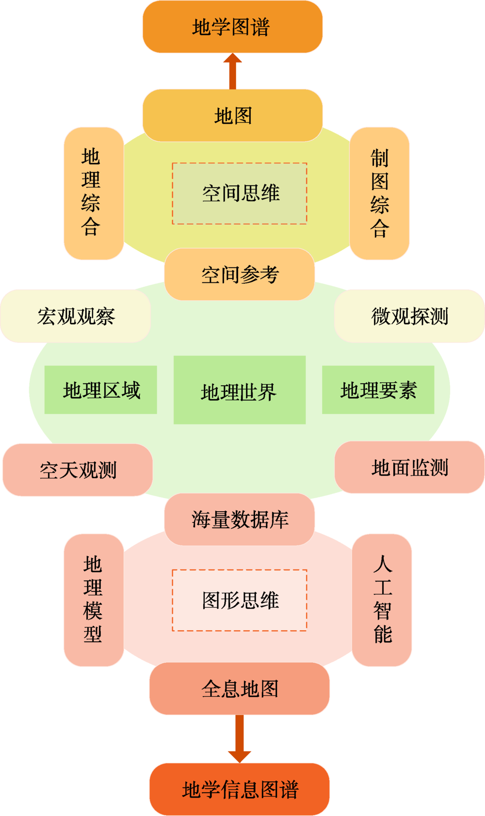
Geo-information Tupu is an important theoretical exploration field advocated by academician Chen Shupeng in the late of 1990s. Tupu is a Chinese word in Pinyin. It could be understood as map series, graph-spectrum, including the meaning of map, chart, graph, spectrum, plan etc., but we could not find a proper term for it in terminology yet. According to Chen's related literature, this paper discusses the connotation of his thought of geo-information Tupu, and holds that Tupu is the methodology of expression and analysis adopted in many fields, while geo-science tupu is a map series of geo-phenomena and processes in the field of geo-science. Geo-information tupu emphasizes quantitative geo-information (geo-database) and geo-computation, supported by geographic information system, it is expected to use geo-graphic language to visualize and analyze geographical phenomena in space and time, and to simulate the law of relationships between man and environment, reconstructing its past, evaluating its present situation and even predicting its future. The idea of geo-information Tupu is closely related to academician Chen's scientific career. Under the guidance of many famous Chinese profesosors, he laid a solid geographical foundation in his youth. In the early stage of career, he participated in a large number of practice of integrated geography and map design. These experiences promoted him to combine the comprehensive thinking of geography with the graphic representation. The development of remote sensing and GIS expanded his vision on geo-technology. In his later years, he put his passion and led China's development in these fields. Geo-information Tupu was developed, which was a collection of rich theories, methods and technical achievements accumulated in the study of geographical science all his life. Geo-information Tupu is a scientific problem that academician Chen Shupeng left to the later generations. Therefore, the authors puts forward some further reserch directions according to the newest related study progress in order to inherit Chen's scientific question. The development of Holographic map is an important basis for the visualization of geo-information Tupu. It is helpful to discover new geographical phenomena and new geographical laws. The "spectrum" detection of land surface information by remote sensing should be supported by the thought of "map" analysis in geography. It fanally come back to answer the core questions of geography, such as the distribution of complex surface and its mechanism. The cognition of geo-information Tupu takes the relationship between man and environment as the center to construct a new cognition theory from real to vitual geographical space. The goal of geo-information Tupu is to assist in the discovery and utilization of new geo-knowledge, and to lay a theoretical and methodological foundation for realizing automatic and intelligent geo-knowledge Tupu.

ZHANG Hongyan , ZHOU Chenghu , LV Guonian , WU Zhifeng , LU Feng , WANG Jinfeng , YUE Tianxiang , LUO Jiancheng , GE Yong , QIN Chengzhi . The Connotation and Inheritance of Geo-information Tupu[J]. Journal of Geo-information Science, 2020 , 22(4) : 653 -661 . DOI: 10.12082/dqxxkx.2020.200167
表1 陈述彭地学信息图谱思想代表性著作Tab. 1 The representative works of Chen Shupeng's geo-information Tupu |
| 序号 | 论文题目 | 完成时间 | 主要内容 | 出处 |
|---|---|---|---|---|
| 1 | 遵义附近的相对地势[2] | 1947年 | 自然与人文相统一,将地理区域研究视为具有“经络”的“地理之生命”的思想 | 《地学的探索》第一卷,地理学[9] |
| 2 | 螳螂川流域之地文与人生[3] | 1947年 | ||
| 3 | 大比例尺景观制图方法及其试验[4] | 1958年 | 以宏观理论指导微观分析,以微观机理论述宏观演化,以图形思维综合制图 | |
| 4 | 自然区划方法与制图实践[5] | 1963年 | ||
| 5 | 《中国地形鸟瞰图集》的编制[6] | 1955年 | 以图形思维系统思考,运用系列地图方式将定性、定量化表达地理学宏观规律 | 《地学的探索》第二卷,地图学[10] |
| 6 | 设计《中华人民共和国大地图集》的 初步意见[7] | 1956年 | ||
| 7 | “数字地球”战略及其制高点[8] | 1999年 | 通过地球信息科学将全球变化科学、对地观测技术和数字化空间服务有机统一起来 | 《地学的探索》第六卷,地球信息科学[11] |
| [1] |
陈述彭 . 地学信息图谱探索研究[M]. 北京: 商务印书馆, 2001.
[
|
| [2] |
陈述彭 . 遵义附近之相对地势[M]// 陈述彭.地学的探索(第一卷):地理学. 北京: 科学出版社, 1990: 1-10.
[
|
| [3] |
陈述彭 . 螳螂川流域之地文与人生[M] // 陈述彭.地学的探索(第一卷):地理学. 北京: 科学出版社, 1990: 29-130.
[
|
| [4] |
陈述彭 . 大比例尺景观制图方法及其实验[M] //陈述彭.地学的探索(第一卷):地理学. 北京: 科学出版社, 1990: 189-211.
[
|
| [5] |
陈述彭 . 自然区划方法与制图实践[M] //陈述彭.地学的探索(第一卷):地理学. 北京: 科学出版社, 1990: 259-275.
[
|
| [6] |
陈述彭 . 《中国地形鸟瞰图集》的编制[M] //陈述彭.地学的探索(第二卷):地图学. 北京: 科学出版社, 1990: 119-130.
[
|
| [7] |
陈述彭 . 设计《中华人民共和国大地图集》的初步意见[M] //陈述彭.地学的探索(第二卷):地图学. 北京: 科学出版社, 1990: 131-160.
[
|
| [8] |
陈述彭 . “数字地球”战略及其制高点[M] //陈述彭.地学的探索(第六卷):地球信息科学. 北京: 科学出版社, 1990: 76-84.
[
|
| [9] |
陈述彭 . 地学的探索(第一卷):地理学[M]. 北京: 科学出版社, 1990.
[
|
| [10] |
陈述彭 . 地学的探索(第二卷):地图学[M]. 北京: 科学出社, 1990.
[
|
| [11] |
陈述彭 . 地学的探索(第六卷):地球信息科学[M]. 北京: 科学出版社, 1990.
[
|
| [12] |
陈述彭 . 香山会议,石坚文存——陈述彭院士科学小品选集[M]. 北京: 中国环境科学出版社, 1999: 386-387.
[
|
| [13] |
陈述彭 . 地学信息图谱案例与诊断图谱方法[M] //陈述彭.地学的探索(第六卷):地球信息科学. 北京: 科学出版社, 2003: 204-208.
[
|
| [14] |
陈述彭 . 地学信息图谱刍议[J]. 地理研究, 1998(增刊):5-9.
[
|
| [15] |
陈述彭 . 地学信息图谱的概念[M] //陈述彭.地学的探索(第六卷):地球信息科学. 北京: 科学出版社, 2003: 209-228.
[
|
| [16] |
陈述彭 . 地学信息图谱的探索[M] //陈述彭.石坚文存——陈述彭院士地学生涯. 北京: 人民教育出版社, 2007: 516.
[
|
| [17] |
陈述彭, 岳天祥, 励惠国 . 地学信息图谱与区域可持续发展虚拟系统[M] //陈述彭.地学的探索(第六卷):地球信息科学. 北京: 科学出版社, 2003: 235-240.
[
|
| [18] |
陈述彭 . 石坚文存——陈述彭院士地学生涯[M]. 北京: 人民教育出版社, 2007: 559-601.
[
|
| [19] |
陈述彭, 杨利普 . 遵义附近之聚落[M] //陈述彭.地学的探索(第一卷):地理学. 北京: 科学出版社, 1990: 11-20.
[
|
| [20] |
陈述彭, 滕俊 等. 中国区域景观典型图(第一号)[M]. 北京: 科学出版社, 1958.
[
|
| [21] |
陈述彭 . 《中华人民共和国自然地图集》总设计书(草案)[M] // 陈述彭.地学的探索(第二卷):地图学. 北京: 科学出版社, 1990: 228-277.
[
|
| [22] |
郭仁忠, 陈业滨, 应申 , 等. 三元空间下的泛地图可视化维度[J]. 武汉大学学报·信息科学版, 2018,43(11):1603-1610.
[
|
| [23] |
周成虎 . 全息地图时代已经来临——地图功能的历史演变[J]. 测绘科学, 2014,39(7):3-8.
[
|
| [24] |
骆剑承, 吴田军, 吴志峰 , 等. 地理图斑智能计算及模式挖掘方法研究[J]. 地球信息科学学报, 2020,22(1):57-75.
[
|
| [25] |
傅伯杰 . 地理学:从知识、科学到决策[J]. 地理学报, 2017,72(11):1923-1932.
[
|
| [26] |
闾国年, 俞肇元, 袁林旺 , 等. 地图学的未来是场景学吗?[J]. 地球信息科学学报, 2018,20(1):1-6.
[
|
| [27] |
王劲峰, 徐成东 . 地理探测器:原理与展望[J]. 地理学报, 2017,72(1):116-134.
[
|
| [28] |
陈述彭, 岳天祥, 励惠国 . 地学信息图谱研究及其应用[J]. 地理研究, 2000,19(4):337-343.
[
|
| [29] |
陆锋, 张恒才 . 大数据与广义GIS[J]. 武汉大学学报·信息科学版, 2014,39(6):645-654.
[
|
| [30] |
陆锋, 余丽, 仇培元 . 论地理知识图谱[J]. 地球信息科学学报, 2017,19(6):723-734.
[
|
/
| 〈 |
|
〉 |