
Journal of Geo-information Science >
Dimensions of Methodologic Researches on Digital Terrain Analysis: Accurate, Efficient, and Easy-to-use
Received date: 2019-12-31
Request revised date: 2020-01-21
Online published: 2020-06-10
Supported by
National Natural Science Foundation of China(41422109)
National Natural Science Foundation of China(41431177)
Copyright
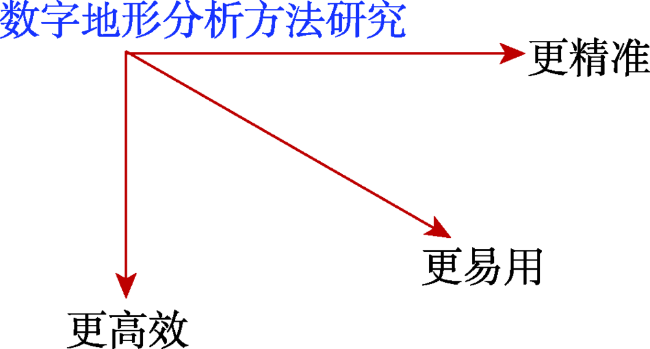
Digital Terrain Analysis (DTA), which can derives all kinds of topographic information widely used in diverse terrain-related geographic modeling and simulation, has been one of basic components of geo-spatial analysis, as well as one of fundamental functionalities of GIS. Researches on DTA methods have been continuously conducted in both width and depth. This paper tries to summarize the DTA researches from a new perspective, i.e., the dimensions of methodologic research on DTA. Three dimensions which successively emerged in methodologic researches on DTA are discussed, i.e., accurate, efficient, and easy-to-use. The dimension of "accurate" is of those researches on how to make DTA results more accurate. The dimension of "efficient" is of those researches on how to make DTA execution more efficient, or faster. And the new-emerging dimension of "easy-to-use" is on how to make DTA more easy-to-use in real applications as well as for users (especially those non-experts of DTA). The key study issue to be settled in the dimension of "easy-to-use" is how to formalize the knowledge on building DTA workflow properly and use it to conduct DTA during diverse real applications in an intelligent way. The proposed summarization on the dimensions of methodologic researches on DTA, as well as the corresponding methodologic researches, should be transferable for other domains in geo-spatial analysis, which often face the study issues similar to those in DTA domain.
QIN Chengzhi . Dimensions of Methodologic Researches on Digital Terrain Analysis: Accurate, Efficient, and Easy-to-use[J]. Journal of Geo-information Science, 2020 , 22(4) : 720 -730 . DOI: 10.12082/dqxxkx.2020.200002
| [1] |
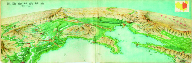
陈述彭 . 中国地形鸟瞰图集[M]. 北京:中华书局, 1954.
[
|
| [2] |
陈述彭 . 中国地形鸟瞰图集的编制工作[J]. 地理学报, 1955,21(1):71-86.
[
|
| [3] |
|
| [4] |
|
| [5] |
|
| [6] |
|
| [7] |
|
| [8] |
周启鸣, 刘学军 . 数字地形分析[M]. 北京: 科学出版社, 2006.
[
|
| [9] |
|
| [10] |
陈述彭, 鲁学军, 周成虎 . 地理信息系统导论[M]. 北京: 科学出版社, 1999.
[
|
| [11] |
王彦文, 秦承志 . 地貌形态类型的自动分类方法综述[J]. 地理与地理信息科学, 2017,33(4):16-21.
[
|
| [12] |
汤国安 . 我国数字高程模型与数字地形分析研究进展[J]. 地理学报, 2014,69(9):1305-1325.
[
|
| [13] |
|
| [14] |
|
| [15] |
|
| [16] |
|
| [17] |
|
| [18] |
|
| [19] |
|
| [20] |
|
| [21] |
杨昕, 汤国安, 刘学军 , 等. 数字地形分析的理论、方法与应用[J]. 地理学报, 2009,64(9):1058-1070.
[
|
| [22] |
|
| [23] |
汤国安, 那嘉明, 程维明 . 我国区域地貌数字地形分析研究进展[J]. 测绘学报, 2017,46(10):1570-1591.
[
|
| [24] |
汤国安 . 面向地貌学本源的数字地形分析[C]. 2019年中国地理学大会,2019年11月1-3日,北京.
[
|
| [25] |
|
| [26] |
|
| [27] |
秦承志, 朱阿兴, 李宝林 , 等. 基于栅格DEM的多流向算法述评[J]. 地学前缘, 2006,13(3):91-98.
[
|
| [28] |
|
| [29] |
|
| [30] |
|
| [31] |
|
| [32] |
秦承志, 朱阿兴, 施迅 , 等. 坡位渐变信息的模糊推理[J]. 地理研究, 2007,26(6):1165-1174,1307.
[
|
| [33] |
|
| [34] |
|
| [35] |
康鑫, 王彦文, 秦承志 , 等. 多分析尺度下综合判别的地形元素分类方法[J]. 地理研究, 2016,35(9):1637-1646.
[
|
| [36] |
|
| [37] |
|
| [38] |
|
| [39] |
|
| [40] |
|
| [41] |
张宏鸣, 杨勤科, 李锐 , 等. 流域分布式侵蚀学坡长的估算方法研究[J]. 水利学报, 2012,43(4):437-443.
[
|
| [42] |
|
| [43] |
|
| [44] |
|
| [45] |
|
| [46] |
汤国安, 刘学军, 房亮 , 等. DEM及数字地形分析中尺度问题研究综述[J]. 武汉大学学报·科学信息版, 2006,31(12):1059-1066.
[
|
| [47] |
秦承志, 呼雪梅 . 栅格数字地形分析中的尺度问题研究方法[J]. 地理研究, 2014,33(2):270-283.
[
|
| [48] |
|
| [49] |
|
| [50] |
张磊, 汤国安, 李发源 , 等. 黄土高原沟沿线研究综述[J]. 地理与地理信息科学, 2012,28(6):44-48.
[
|
| [51] |
|
| [52] |
|
| [53] |
|
| [54] |
|
| [55] |
|
| [56] |
|
| [57] |
|
| [58] |
宋效东, 刘学军, 汤国安 , 等. 并行数字地形分析的容错算法研究[J]. 地理与地理信息科学, 2013,29(2):1-5.
[
|
| [59] |
|
| [60] |
|
| [61] |
|
| [62] |
|
| [63] |
|
| [64] |
|
| [65] |
艾贝贝, 秦承志, 朱阿兴 . 栅格地理计算并行算子对区域计算算法并行化的可用性分析——以多流向算法为例[J]. 地球信息科学学报, 2015,17(5):562-567.
[
|
| [66] |
|
| [67] |
|
| [68] |
|
| [69] |
秦承志, 卢岩君, 包黎莉 , 等. 简化数字地形分析软件(SimDTA)及其应用——以嫩江流域鹤山农场的坡位模糊分类应用为例[J]. 地球信息科学学报, 2009,11(6):737-743.
[
|
| [70] |
|
| [71] |
|
| [72] |
|
| [73] |
|
| [74] |
|
| [75] |
U.S. Geological Survey. The national map: New data delivery homepage, advanced viewer, lidar visualizationv[EB/OL]. US. Geological Survey Fact Sheet 2019-3032. 2019. https://doi.org/10.3133/fs20193032
|
| [76] |
|
| [77] |
|
| [78] |
|
| [79] |
|
| [80] |
|
| [81] |
|
| [82] |
|
| [83] |
|
| [84] |
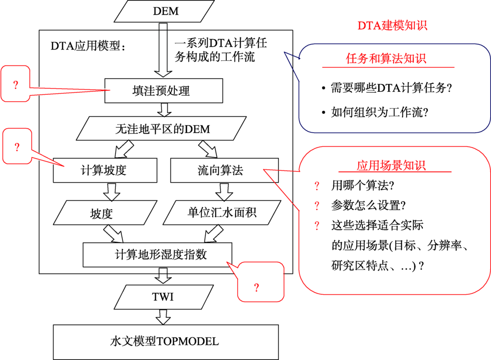
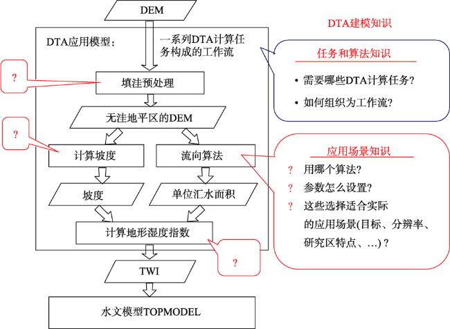
吴雪薇, 秦承志, 朱阿兴 . 数字地形分析应用适配性知识的案例表达与推理应用方法[J]. 地理科学进展, 2016,35(1):89-97.
[
|
| [85] |
|
| [86] |
|
/
| 〈 |
|
〉 |