
Journal of Geo-information Science >
Research on the Characteristics of Urban Network Assocoation and Spatial Organization Structure based on Railway Passenger Flow in Hubei Province
Received date: 2019-09-22
Request revised date: 2020-01-16
Online published: 2020-07-25
Supported by
National Natural Science Foundation of China(51878515)
Copyright
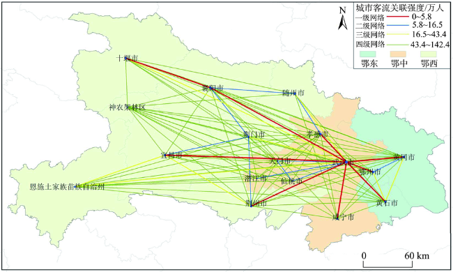
Based on the data of railway passenger flow, this paper uses the urban network model to analyze the characteristics of network connection strength and organizational structure in Hubei Province from the mobility and agglomeration of railway passenger flow between cities. Results show that: (1) The urban network structure within the scope of Hubei Province has initially formed, showing the overall trend of “strong in the east, weak in the west, low in the north, and high in the south”. At the same time, within the scope of Hubei Province, the single-center network pattern is obvious while the cross-regional links are weak; (2) The directivity of the central city and the regional proximity are obvious, and the whole province is greatly influenced by Wuhan. The eight surrounding cities closely related to them are the main parts of Wuhan “1+8” urban circle; (3) The traffic axis is the main direction of passenger flow connection, with Shiyan-Xiangyang-Jingmen-Wuhan, and Enshi-Yichang-Jingzhou-Wuhan as the main cities, the “>” type cities with passenger flow are closely linked. Moreover, the pivotal role of Xiangyang and Yichang in Western Hubei has become increasingly prominent. Finally, based on empirical research, this paper makes some discussion on the meaning, trend, and orientation of provincial spatial planning.

LIU Quanyi , ZHAN Qingming , LIU Wen , YANG Chen . Research on the Characteristics of Urban Network Assocoation and Spatial Organization Structure based on Railway Passenger Flow in Hubei Province[J]. Journal of Geo-information Science, 2020 , 22(5) : 1008 -1022 . DOI: 10.12082/dqxxkx.2020.190539
表1 跨区域间城市客流强度Tab. 1 The intensity of cross-regional urban passenger flow (万人) |
| 出发地 | 目的地 | |||
|---|---|---|---|---|
| 武汉 | 鄂中城市(除武汉) | 鄂东城市 | 鄂西城市 | |
| 武汉 | — | 144.22 | 171.75 | 116.03 |
| 鄂中城市(除武汉) | 152.94 | — | 6.03 | 9.05 |
| 鄂东城市 | 183.54 | 4.71 | — | 39.66 |
| 鄂西城市 | 128.29 | 7.27 | 24.00 | — |
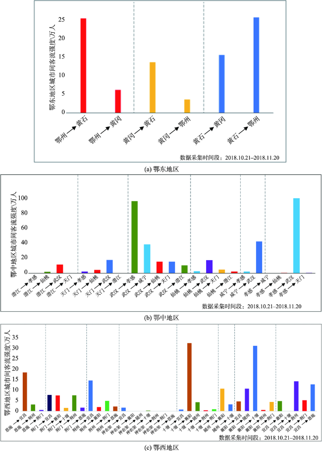
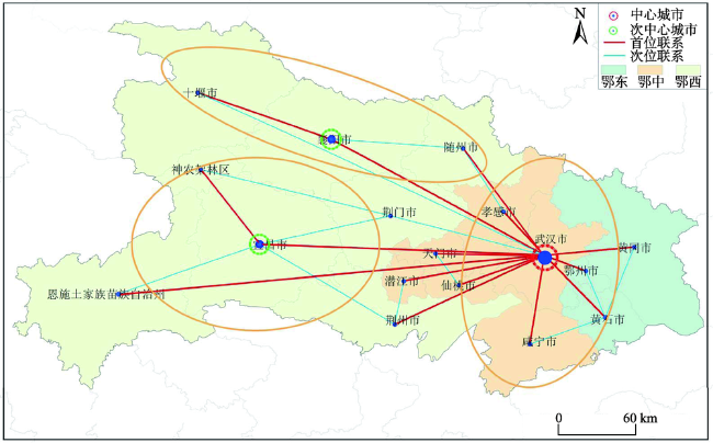
图5 湖北省城市间铁路客流首、次位联系结构注:上图中的椭圆是依据城市间首、次位联系形成的区域组团结构。 Fig. 5 Inter-city railway passenger flow and directions in Hubei province |
表2 跨区域最大客流方向以及强度Tab. 2 Maximum passenger flow direction and intensity across the region (万人) |
| 出发地 | 目的地 | |||
|---|---|---|---|---|
| 武汉 | 鄂中城市(除武汉) | 鄂东城市 | 鄂西城市 | |
| 武汉 | — | 武汉-黄冈(75.71) | 武汉-孝感(93.02) | 武汉-襄阳(43.20) |
| 鄂中城市(除武汉) | 黄冈-武汉(80.96) | — | 武汉-孝感(93.02) | 黄冈-恩施(4.96) |
| 鄂东城市 | 孝感-武汉(96.84) | 咸宁-黄石(2.75) | — | 孝感-随州(9.84) |
| 鄂西城市 | 襄阳-武汉(50.09) | 恩施-黄冈(2.83) | 随州-孝感(93.02) | — |
表3 湖北省各地级市铁路客流方向与总客流强度Tab. 3 Railway passenger flow direction and total passenger flow intensity of all prefecture-level cities in Hubei province (万人) |
| 首位客流城市 | 次位客流城市 | 关联首位度 | 迁入客流量 | 迁出客流量 | |
|---|---|---|---|---|---|
| 鄂州 | 武汉(37.05) | 黄石(22.53) | 1.64 | 71.55 | 72.16 |
| 恩施州 | 武汉(27.68) | 宜昌(16.43) | 1.68 | 54.39 | 40.05 |
| 黄冈 | 武汉(80.96) | 黄石(12.09) | 6.70 | 101.84 | 95.73 |
| 黄石 | 武汉(34.93) | 鄂州(22.77) | 1.53 | 79.91 | 78.67 |
| 荆门 | 武汉(29.56) | 宜昌(6.92) | 4.27 | 58.33 | 53.91 |
| 荆州 | 武汉(43.44) | 宜昌(13.21) | 3.31 | 67.96 | 62.50 |
| 潜江 | 武汉(11.38) | 荆州(3.23) | 3.52 | 21.19 | 20.31 |
| 神农架 | 宜昌(1.51) | 武汉(0.91) | 1.65 | 3.29 | 2.91 |
| 十堰 | 武汉(31.28) | 襄阳(28.88) | 1.08 | 71.03 | 64.57 |
| 随州 | 武汉(28.60) | 孝感(10.09) | 2.83 | 51.54 | 50.71 |
| 天门 | 武汉(17.26) | 仙桃(4.41) | 3.91 | 28.49 | 26.38 |
| 武汉 | 孝感(97.08) | 黄冈(75.71) | 1.23 | 372.76 | 429.33 |
| 仙桃 | 武汉(16.81) | 天门(4.65) | 3.61 | 30.53 | 29.22 |
| 咸宁 | 武汉(31.25) | 黄石(4.25) | 7.64 | 49.52 | 45.05 |
| 襄阳 | 武汉(50.09) | 十堰(27.69) | 1.81 | 100.11 | 91.54 |
| 孝感 | 武汉(96.84) | 随州(9.84) | 9.84 | 120.49 | 119.94 |
| 宜昌 | 武汉(36.72) | 荆州(12.71) | 2.89 | 73.19 | 70.55 |
注:括号内的数据表示每个城市首、次位联系强度的测量值。 |
| [1] |
程遥, 王理. 流动空间语境下的中心流理论再思考——以山东省域城市网络为例[J]. 经济地理, 2017,37(12):25-33.
[
|
| [2] |
万艳华, 罗丹, 余思雨. 湖北省城镇化发展政策实施评估研究[J]. 城市规划学刊, 2011,18(5):37-47.
[
|
| [3] |
中共中央,国务院. 《国家新型城镇化规划(2014–2020年)》. http://www.gov.cn/gongbao/content/2014/content_2644805.htm, 2014-03-16.
[ Central committee of the communist party of China, state council, National plan for new urbanization(2014-2020). http://www.gov.cn/gongbao/content/2014/content_2644805.htm, 2014-03-16. ]
|
| [4] |
中华人民共和国国家发展和改革委员会. 《中华人民共和国国民经济和社会发展第十三个五年规划纲要》. https://www.ndrc.gov.cn/, 2016 -05-05.
[ National development and reform commission of the People's Republic of China. Outline of the 13th five-year plan for national economic and social development of the People's Republic of China. https://www.ndrc.gov.cn/, 2016 -05-05. ]
|
| [5] |
清华大学中国新型城镇化研究院, 北京清华同衡规划设计院. 《中国都市圈发展报告2018》发布[J]. 城市规划通讯, 2019(6):12.
[ China institute of new urbanization, tsinghua university, Beijing tsinghuatongheng planning and design institute. China metropolitan area development report 2018 [J]. Urban planning newsletter, 2019(6):12. ]
|
| [6] |
宋家泰, 顾朝林. 城镇体系规划的理论与方法初探[J]. 地理学报, 1988,42(2):97-107.
[
|
| [7] |
姚士谋, 陈振光, 叶高斌, 等. 中国城市群基本概念的再认知[J]. 城市观察, 2015,35(1):73-82.
[
|
| [8] |
孙阳, 姚士谋, 张落成. 中国沿海三大城市群城市空间网络拓展分析——以综合交通信息网络为例[J]. 地理科学, 2018,38(6):827-837.
[
|
| [9] |
周一星, 胡智勇. 从航空运输看中国城市体系的空间网络结构[J]. 地理研究, 2002,21(3):276-286.
[
|
| [10] |
沈丽珍, 罗震东, 陈浩. 区域流空间的关系测度与整合——以湖北省为例[J]. 城市问题, 2011,30(12):30-35.
[
|
| [11] |
程遥, 赵民. 新时期我国建设“全球城市”的辨析与展望——基于空间组织模型的视角[J]. 城市规划, 2015,39(2):9-15.
[
|
| [12] |
魏冶, 修春亮, 刘志敏, 等. 春运人口流动透视的转型期中国城市网络结构[J]. 地理科学, 2016,36(11):1654-1660.
[
|
| [13] |
李涛, 程遥, 张伊娜, 等. 城市网络研究的理论、方法与实践[J]. 城市规划学刊, 2017,24(6):43-49.
[
|
| [14] |
甄峰, 王波, 陈映雪. 基于网络社会空间的中国城市网络特征——以新浪微博为例[J]. 地理学报, 2012,67(8):1031-1043.
[
|
| [15] |
|
| [16] |
|
| [17] |
|
| [18] |
|
| [19] |
|
| [20] |
|
| [21] |
程玉鸿, 程灵云. 基于城市竞合视角的城市竞争力来源分析——以大珠三角地区为例[J]. 城市问题, 2014(12):25-31.
[
|
| [22] |
王发曾, 郭志富, 刘晓丽, 等. 基于城市群整合发展的中原地区城市体系结构优化[J]. 地理研究, 2007,26(4):637-650.
[
|
| [23] |
史雅娟, 朱永彬, 冯德显, 等. 中原城市群多中心网络式空间发展模式研究[J]. 地理科学, 2012,32(12):1430-1438.
[
|
| [24] |
刘正兵, 刘静玉, 何孝沛, 等. 中原经济区城市空间联系及其网络格局分析——基于城际客运流[J]. 经济地理, 2014,34(7):58-66.
[
|
| [25] |
孙东琪, 张京祥, 胡毅, 等. 基于产业空间联系的“大城市阴影区”形成机制解析——长三角城市群与京津冀城市群的比较研究[J]. 地理科学, 2013,33(9):1043-1050.
[
|
| [26] |
刘望保, 石恩名. “百度迁徙”下中国城市间的人口流空间格局[J]. 华南师范大学学报(自然科学版), 2016,48(5):67-73.
[
|
| [27] |
赵渺希, 刘铮. 基于生产性服务业的中国城市网络研究[J]. 城市规划, 2012,36(9):23-28.
[
|
| [28] |
赵渺希, 唐子来. 基于网络关联的长三角区域腹地划分[J]. 经济地理, 2010,30(3):371-376.
[
|
| [29] |
曹子威, 罗震东, 耿磊. 基于信息流的城市—区域关系比较研究——以马鞍山和芜湖为例[J]. 经济地理, 2013,33(5):47-53.
[
|
| [30] |
王垚, 钮心毅, 宋小冬, 等. 人流联系和经济联系视角下区域城市关联比较——基于手机信令数据和企业关联数据的研究[J]. 人文地理, 2018,33(2):84-91.
[
|
| [31] |
潘碧麟, 王江浩, 葛咏, 等. 基于微博签到数据的武康城市群空间结构及其城际人口流动研究[J]. 地球信息科学学报, 2019,21(1):68-76.
[
|
| [32] |
孙阳, 张落成, 姚士谋. 长三角城市群“空间流”网络结构特征——基于公路运输、火车客运及百度指数的综合分析[J]. 长江流域资源与环境, 2017,26(9):1304-1310.
[
|
| [33] |
李涛, 周锐. 长三角地区网络腹地划分的关联测度方法比较[J]. 地理学报, 2016,71(2):236-250.
[
|
| [34] |
陈伟劲, 马学广, 蔡莉丽, 等. 珠三角城市联系的空间格局特征研究——基于城际客运交通流的分析[J]. 经济地理, 2013,33(4):48-55.
[
|
| [35] |
罗震东, 何鹤鸣, 耿磊. 基于客运交通流的长江三角洲功能多中心结构研究[J]. 城市规划学刊, 2011,18(2):16-23.
[
|
| [36] |
钮心毅, 王垚, 丁亮. 利用手机信令数据测度城镇体系的等级结构[J]. 规划师, 2017,33(1):50-56.
[
|
| [37] |
朱查松, 曹子威, 罗震东. 基于流空间的山东省域城市间关系研究[J]. 城乡规划, 2017,6(4):85-93.
[
|
| [38] |
孙平军, 丁四保, 修春亮, 等. 湖北“人口—经济—空间”城市化及其层级结构[J]. 长江流域资源与环境, 2011,20(10):1172-1179.
[
|
| [39] |
车冰清, 简晓彬, 陆玉麒. 江苏省商业网点的空间分布特征及其区域差异因素[J]. 地球信息科学学报, 2017,19(8):1060-1068.
[
|
| [40] |
敖荣军, 蒋亮, 张涛, 等. 湖北省县域迁入人口的空间格局及影响因素[J]. 长江流域资源与环境, 2016,25(11):1672-1678.
[
|
| [41] |
赵心怡, 蒲英霞. 区域人口迁移时空溢出效应与动力机制分析[J]. 地球信息科学学报, 2018,20(6):817-826.
[
|
| [42] |
于涛方. 京津冀全球城市区域边界研究[J]. 地理与地理信息科学, 2005,21(4):45-50.
[
|
| [43] |
湖北省规划设计院. 《湖北省城镇体系规划(2001—2020)》. http://www.hbucdi.com.cn/, 2001-02-10.
[ Planning and design institute of Hubei province. Hubei province urban system planning (2001-2020). http://www.hbucdi.com.cn/, 2001-02-10. ]
|
| [44] |
湖北省交通运输厅. 《湖北省综合交通运输“十三五”发展规划》. http://wuhan.gov.cn/, 2006-09-10.
[ Hubei province transportation hall. The comprehensive transportation inHubeiprovince "much starker choices-and graver consequences-in" development plan". http://wuhan.gov.cn/, 2006-09-10. ]
|
/
| 〈 |
|
〉 |