
Journal of Geo-information Science >
Progress of the DEM Application for Studying Lake Hydrologic Dynamics
Received date: 2019-09-23
Request revised date: 2020-02-27
Online published: 2020-09-25
Supported by
Strategic Priority Research Program of the Chinese Academy of Sciences(XDA23100102)
National natural science foundation of China(41801321)
Key project of national key research and development plan(2018YFD1100101)
National natural science foundation of China(41701464)
Copyright
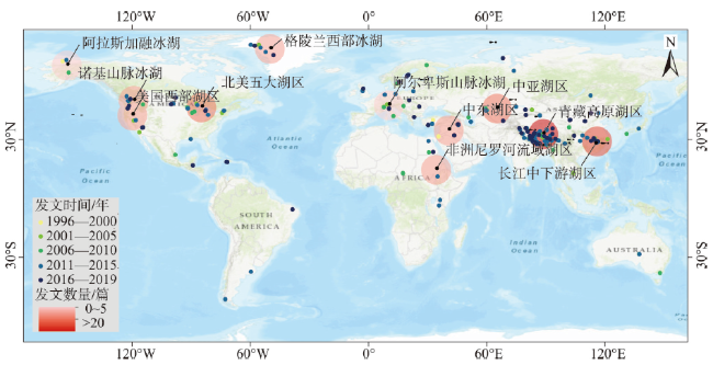
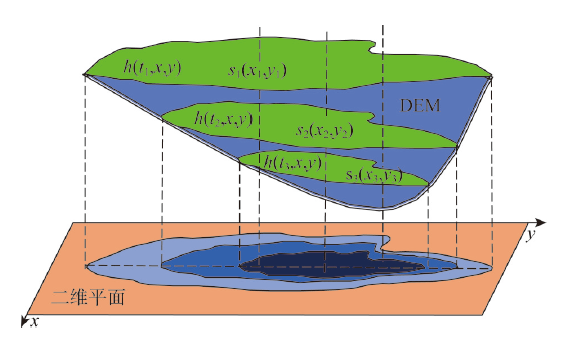
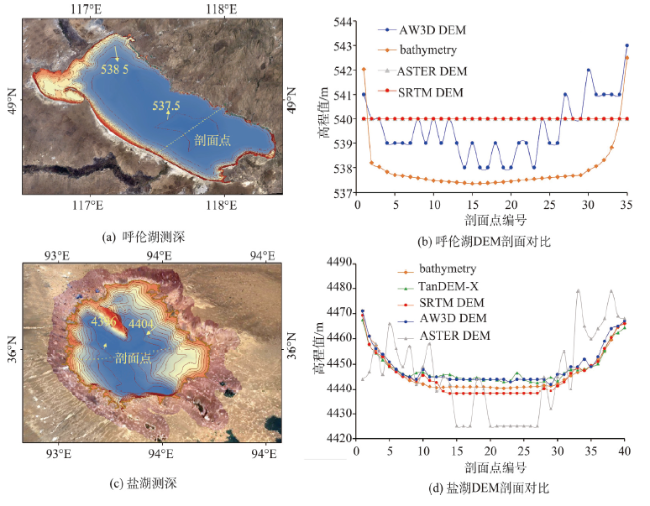
:The dynamics of lake hydrology is not only an important indicator for assessing and predicting climate change, but also poses important impacts on the sustainable development of regional society, the utilization of water resources, and the construction of ecological civilization. The changes of lakes are controlled by the topography of lakeside and underwater bathymetry. Hence, the topographic information is essential to quantify the lake variations. With the development of remote sensing technology, the methods for high-resolution data acquisition at large scale have been improved largely. Currently, DEM has been widely used in the studies of lake hydrology. This study collected the related literatures based on Web of Science platform, with a quantitative analysis in terms of published time, study area and adopted datasets. Then, the research literature can be categorized in four main fields including: Lake water extent change, lake water level change, lake water volume change and lake hydrological disaster. To take full advantages of DEM, three aspects of efforts should be further paid, specifically in (1) integrating DEM with multiple other sources including remote sensing images, satellite altimetry and hydrological observations, (2) developing state-of-artdata fusion strategy by integrating digital terrain analysis and hydrological analysis, and (3) improving the performances of DEM data in resolution and accuracy for lake hydrology study. Finally, this paper discusses the key problems of DEM in lake hydrology research, and puts forward possible solutions and research prospective based on the development trend of technology and hot issues.

LUO Zhu , LIU Kai , ZHANG Chunkang , DENG Xinyuan , MA Ronghua , SONG Chunqiao . Progress of the DEM Application for Studying Lake Hydrologic Dynamics[J]. Journal of Geo-information Science, 2020 , 22(7) : 1510 -1521 . DOI: 10.12082/dqxxkx.2020.190538
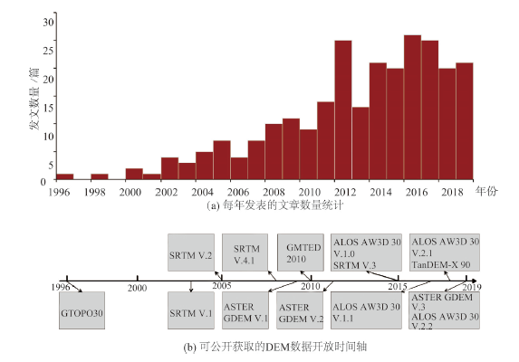
表1 全球常用的开放DEM数据集Tab. 1 Commonly-used global (or near global)-scale DEM datasets |
| 数据名称 | 覆盖 | 获取原理 | 测量时间 | 主要数据版本 | 数据处理 | 发布机构 | 下载地址 | 发布时间 | 分辨率/m |
|---|---|---|---|---|---|---|---|---|---|
| SRTM DEM | 56°S~60° N | SAR-C 波段 | 2000.02 | SRTM V.1 | 未编辑 | USGS | http://earthexplorer.usgs.gov | 2003 | 90 |
| SRTM V4.1 | 填补空洞,对水体进行了处理 | CGIAR | http://srtm.csi.cgiar.org/srtmdata/ | 2008 | 90 | ||||
| SRTM V.3 | 采用ASTER DEMs、GMTED2010、NED作为辅助数据源填补空洞、提高分辨率和精度,对水体进行了处理 | NASA、USGS | https://dwtkns.com/srtm30m/ | 2015 | 30 | ||||
| SRTM X-SAR DEM | 56°S~60° N | SAR-X 波段 | 2000.02 | SRTM X-SAR DEM | 未编辑 | DLR | https://download.geoservice.dlr.de/SRTM_XSAR/#download | 2010 | 30 |
| ASTER DEM | 83°S~83° N | 光学传感器 | 2000—2011 | ASTER GDEM V.1 | 230万张影像立体测图自动化处理 | METI、NASA | https://gdemdl.aster.jspacesystems.or.jp/ | 2009 | 90 |
| 2000—2013 | ASTER GDEM V.2 | 提高精度、分辨率及水体的准确性,减少人工误差 | METI、NASA | 2011 | 30 | ||||
| 2000—2013 | ASTER GDEM V.3 | 填补空洞,使用新的全球水体数据处理水体,减少水域异常 | METI、NASA | 2019 | 30 | ||||
| AW3D DEM | 60°S~60° N | 光学传感器 | 2006—2011 | ALOS AW3D 30 V.1.0 | 300万张影像立体测图自动化处理 | JAXAEORC | https://www.eorc.jaxa.jp/ALOS/en/aw3d30/ | 2016 | 30 |
| 2006—2011 | ALOS AW3D 30 V.2.2 | 填补空洞,对数据质量差的区域进行修补,对海岸线进行了更新 | JAXAEORC | 2019 | 30 | ||||
| TanDEM-X | 全球 | SAR-X 波段 | 2010—2015 | TanDEM-X 90 | 未编辑 | DLR | https://download.geoservice.dlr.de/TDM90 | 2018 | 90 |
注:NGDC(美国地球物理中心);DLR(德国中央情报局);JAXA(日本航空航天局);JAXA EORC(日本航空航天局地球观测研究中心);METI(日本经济产业省);NASA(美国国家航空航天局);NGIA(美国国家地理空间情报局)、DLR(德国中央情报局);ASI (意大利航天署);CGIAR(国际农业研究咨询小组)。 |
| [1] |
拉巴, 陈涛, 拉巴卓玛, 等. 基于MODIS影像的色林错湖面积变化及成因[J]. 气象与环境学报, 2011,27(2):69-72.
[ Laba,
|
| [2] |
魏善蓉, 金晓媚, 王凯霖, 等. 基于遥感的柴达木盆地湖泊面积变化与气候响应分析[J]. 地学前缘, 2017,24(5):427-433.
[
|
| [3] |
姜丽光, 姚治君, 刘兆飞, 等. 湖泊动态变化遥感研究综述[J]. 遥感技术与应用, 2013,28(5):807-14.
[
|
| [4] |
|
| [5] |
闾利, 张廷斌, 易桂花, 等. 2000年以来青藏高原湖泊面积变化与气候要素的响应关系[J]. 湖泊科学, 2019,31(2):573-589.
[
|
| [6] |
|
| [7] |
|
| [8] |
阿布都米吉提·阿布力克木 葛拥晓, 王亚俊, 等. 咸海的过去、现在与未来[J]. 干旱区研究, 2019,36(1):7-18.
[
|
| [9] |
汤国安. 我国数字高程模型与数字地形分析研究进展[J]. 地理学报, 2014,69(9):1305-1325.
[
|
| [10] |
|
| [11] |
|
| [12] |
|
| [13] |
吴桂平, 刘元波, 范兴旺. 近30年来鄱阳湖湖盆地形演变特征与原因探析[J]. 湖泊科学, 2015,27(6):1168-1176.
[
|
| [14] |
|
| [15] |
|
| [16] |
|
| [17] |
|
| [18] |
乔程, 骆剑承, 盛永伟, 等. 青藏高原湖泊古今变化的遥感分析—以达则错为例[J]. 湖泊科学, 2010,22(1):98-102.
[
|
| [19] |
|
| [20] |
|
| [21] |
|
| [22] |
|
| [23] |
|
| [24] |
张涛, 吴剑锋, 林锦, 等. 基于水量平衡的博斯腾湖水位变化分析[J]. 水文, 2015(3):80-85.
[
|
| [25] |
朱长明, 张新, 路明, 等. 湖盆数据未知的湖泊动态库容遥感监测方法[J]. 测绘学报, 2015,3:309-315.
[
|
| [26] |
李涛, 吴胜军, 蔡述明, 等. Simulation analysis of the storage capacity based on DEM before and after connecting to Yangtze River in Zhangdu lake[J]. Journal of Jilin University(Earth Science Edition), 2005,35(3):351-355.
|
| [27] |
|
| [28] |
|
| [29] |
|
| [30] |
|
| [31] |
|
| [32] |
|
| [33] |
|
| [34] |
李鹏, 李振洪, 施闯, 等. 中国地区30m分辨率SRTM质量评估[J]. 测绘通报, 2016(9):24-28.
[
|
| [35] |
|
| [36] |
王海波, 马明国. 基于遥感的湖泊水域动态变化监测研究进展[J]. 遥感技术与应用, 2009,24(5):674-684.
[
|
| [37] |
杨珂含, 姚方方, 董迪, 等. 青藏高原湖泊面积动态监测[J]. 地球信息科学学报, 2017,19(7):972-982.
[
|
| [38] |
傅晓俊, 袁琳琳, 魏翔. 基于遥感影像水体提取方法的比较与分析[J]. 测绘与空间地理信息, 2019,42(8):158-160.
[
|
| [39] |
骆剑承, 盛永伟, 沈占锋, 等. 分步迭代的多光谱遥感水体信息高精度自动提取[J]. 遥感学报, 2009,13(4):604-615.
[
|
| [40] |
张明华. 用改进的谱间关系模型提取极高山地区水体信息[J]. 地理与地理信息科学, 2008,24(2):14-16.
[
|
| [41] |
车向红, 冯敏, 姜浩, 等. 2000-2013年青藏高原湖泊面积MODIS遥感监测分析[J]. 地球信息科学学报, 2015,17(1):99-107.
[
|
| [42] |
|
| [43] |
|
| [44] |
|
| [45] |
齐述华, 顾中宇, 顾中宇, 等. 基于数字高程模型的鄱阳湖淹水范围制图研究[J]. 武汉大学学报·信息科学版, 2010,35(7):857-862.
[
|
| [46] |
|
| [47] |
李建成, 褚永海, 姜卫平, 等. 利用卫星测高资料监测长江中下游湖泊水位变化[J]. 武汉大学学报·信息科学版, 2007,32(2):144-147.
[
|
| [48] |
|
| [49] |
|
| [50] |
|
| [51] |
张鑫, 吴艳红. 1972-2012年青藏高原中南部内陆湖泊的水位变化[J]. 地理学报, 2014,69(7):993-1001.
[
|
| [52] |
|
| [53] |
|
| [54] |
|
| [55] |
张国庆. 青藏高原湖泊变化遥感监测及其对气候变化的响应研究进展[J]. 地理科学进展, 2018,37(2):214-223.
[
|
| [56] |
|
| [57] |
|
| [58] |
|
| [59] |
|
| [60] |
|
| [61] |
|
| [62] |
陈晓清, 崔鹏, 程尊兰, 等. 5.12汶川地震堰塞湖危险性应急评估[J]. 地学前缘, 2008,15(4):244-249.
[
|
| [63] |
|
| [64] |
张细兵, 卢金友, 范北林, 等. 唐家山堰塞湖溃坝洪水演进及下泄过程复演[J]. 人民长江, 2008,39(22):76-78.
[
|
| [65] |
|
| [66] |
|
| [67] |
|
| [68] |
薛超, 熊伟. 世界主要国家商用遥感卫星发展计划概述[J]. 中国测绘, 2017(2):42-47.
[
|
| [69] |
|
| [70] |
|
| [71] |
沈德福, 李世杰, 陈炜, 等. 黄河源区鄂陵湖现代湖盆形态研究[J]. 地理科学, 2011,31(10):1261-1265.
[
|
| [72] |
陈安娜, 马毅, 张靖宇. 水深被动光学遥感反演模型适用性研究[J]. 海洋环境科学, 2018,37(6):953-960.
[
|
| [73] |
|
| [74] |
|
| [75] |
梁志诚, 黄文骞, 杨杨, 等. 基于神经网络技术的多因子遥感水深反演模型[J]. 测绘工程, 2012,21(4):17-21.
[
|
| [76] |
|
| [77] |
|
/
| 〈 |
|
〉 |