
Journal of Geo-information Science >
InSAR Tropospheric Delay Error Correction Algorithm based on Multi-Scale Correlation Analysis
Received date: 2020-02-08
Request revised date: 2020-05-18
Online published: 2020-11-25
Supported by
National Natural Science Foundation of China(41531068)
National Natural Science Foundation of China(41671356)
Natural Science Foundation of Hunan Province, No.2020JJ4031(2020JJ4031)
Education Science Planning Research Results of Hunan Province(XJK19CGD051)
Copyright
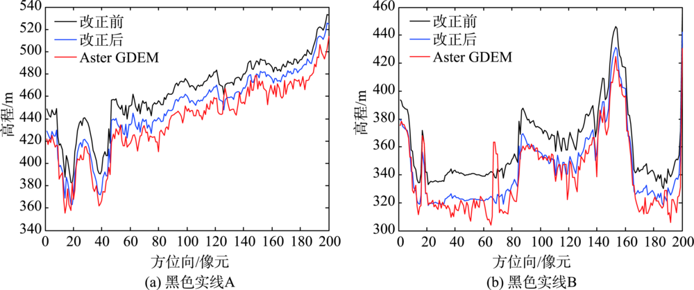
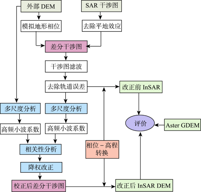
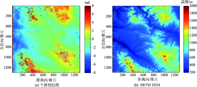
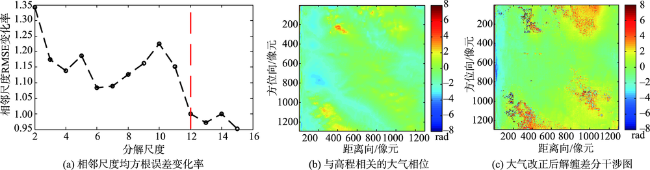
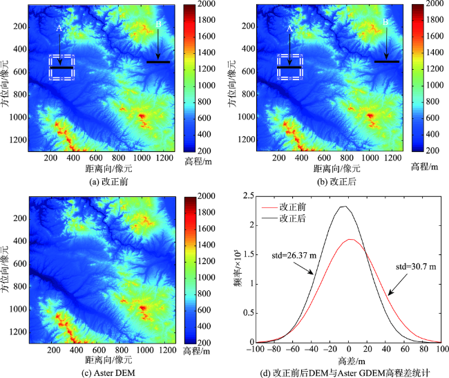
Tropospheric delay error in synthetic aperture radar interferometry can affect DEM accuracy. This study adopts wavelet multi-scale correlation analysis to reduce the influence of tropospheric delay error on DEM estimation. This method is based on the wavelet multi-resolution analysis theory and the frequency characteristics of different components in differential interference phases. Firstly, the wavelet decomposition reconstruction RMS error rate is used to determine the decomposition layers. The terrain residual phase and noise phase are reduced to extract the frequency band where the troposphere delayed error phase is located. Secondly, we quantify the correlation between tropospheric delay error phase and DEM in radar coordinates and further down-weight the correlated coefficients. Lastly, the differential interferogram is reconstructed which reduces the influence of elevation-related tropospheric delay in InSAR. In this study, the ENVISAT ASAR data in Yima, Henan province are processed using the method proposed in this study. The differential interferogram with tropospheric delay error corrected are obtained to estimate elevation. The estimated tropospheric delay phase correlated with elevation is consistent with the topographic changes. Results show that the standard deviation of DEM error compared to Aster GDEM decreases from 30.7 m to 26.37 m, which indicates an increased accuracy of InSAR DEM.
HE Yonghong , JIN Pengwei , SHU Min . InSAR Tropospheric Delay Error Correction Algorithm based on Multi-Scale Correlation Analysis[J]. Journal of Geo-information Science, 2020 , 22(9) : 1878 -1886 . DOI: 10.12082/dqxxkx.2020.200061
表1 义马实验区ENVISAT卫星ASAR数据列表Tab. 1 Data list of envisat satellite Asar in Yima experimental area |
| 影像 | 成像日期 | 轨道号 | Track | 垂直基线 |
|---|---|---|---|---|
| 主影像 | 2006-11-19 | 24678 | 75 | 166 |
| 从影像 | 2007-01-28 | 25680 | 75 |
| [1] |
|
| [2] |
郭唯娜, 柯长青, 范宇宾. 基于SAR干涉数据的东帕米尔高原冰川变化[J]. 地球信息科学学报, 2019,21(11):1790-1801.
[
|
| [3] |
杨书成, 黄国满, 程春泉. 基于DEM的SAR影像几何定位参数校正方法[J]. 地球信息科学学报, 2019,21(4):580-587.
[
|
| [4] |
|
| [5] |
|
| [6] |
丁刘建, 陶秋香, 李涛, 等. 高分三号SAR影像广域范围联合几何检校技术[J]. 测绘学报, 2020,49(5):598-610.
[
|
| [7] |
|
| [8] |
|
| [9] |
|
| [10] |
|
| [11] |
朱建军, 李志伟, 胡俊. InSAR变形监测方法与研究进展[J]. 测绘学报, 2017,46(10):1717-1733.
[
|
| [12] |
|
| [13] |
|
| [14] |
|
| [15] |
|
| [16] |
|
| [17] |
|
| [18] |
|
| [19] |
|
| [20] |
何永红, 朱建军, 靳鹏伟. 一种使用剪切波变换的干涉图滤波算法[J]. 武汉大学学报·信息科学版, 2018,43(7):1008-1014.
[
|
| [21] |
|
| [22] |
|
| [23] |
陶珂, 朱建军. 多指标融合的小波去噪最佳分解尺度选择方法[J]. 测绘学报, 2012,41(5):749-755.
[
|
/
| 〈 |
|
〉 |