
Journal of Geo-information Science >
Retrieval of Aerosol Optical Depth Using FY3D MERSI2 Data
Received date: 2019-05-05
Request revised date: 2020-01-06
Online published: 2020-11-25
Supported by
National Environmental Protection Standard Preparation and Revision Project(2017-27)
Causes of Heavy Air Pollution and Tackling Key Problems(DQGG0205)
Copyright
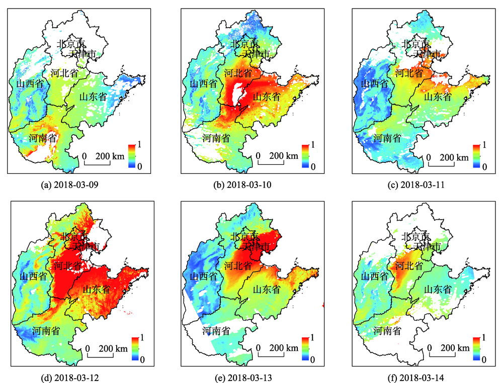
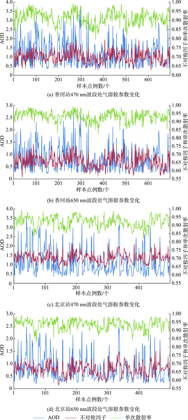
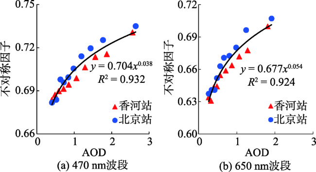
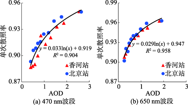
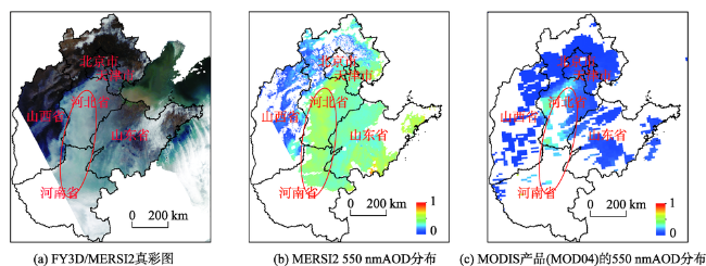
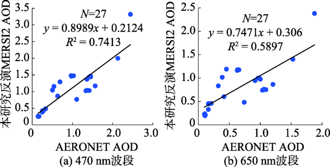
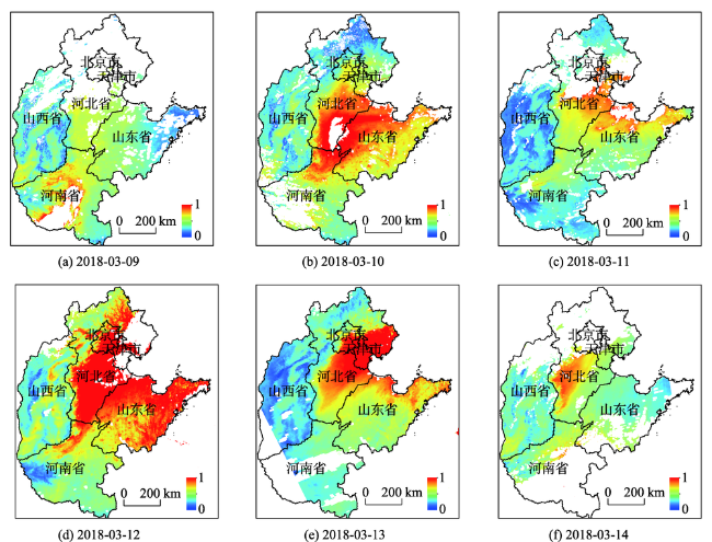
Until now, relatively few researches of aerosols retrieval have been conducted using domestic satellite remote sensing. To promote domestic satellite remote sensing applications, a set of rapid inversion technology of Aerosol Optical Depth (AOD) using remote sensing was developed in this study based on FY-3D/MERSI2 data, which combined the advantages of Dark Target (DT) and SARA algorithm. Firstly, the empirical relationship of surface reflectance in traditional Dark Target algorithm was introduced to get the red and blue band surface reflectance. Then, the relationships between aerosol optical thickness, asymmetry factor, and single scattering albedo in red and blue bands were established using long time-series ground observation data from AERONET. Finally, MOD04 and AERONET AOD products were used to validate and evaluate the inversion results. Results show that the AOD retrieved from MERSI2 in this study not only kept the spatial consistency with the MODIS aerosol product, but also presented a reasonable distribution of high AOD values, which improved the AOD inversion in cloud and bright target areas where values were missing in MOD04 aerosol product. Meanwhile, compared with ground-based observations, the proposed algorithm also demonstrated a higher accuracy with an average correlation coefficient greater than 0.85 at the 470nm band. These two methods showed a strong linear correlation at blue band. Finally, the spatial and temporal distribution of aerosols during a heavy pollution in Beijing, Tianjin, Hebei, and surrounding areas from March 9 to March 14 in 2018 was completely captured using MERSI2, which indicated that FY3D satellite was able to monitor aerosols and could provide a reference for haze monitoring and early warning in China. This study provides important reference significance for the development and application of domestic satellites in atmospheric remote sensing business.
CHEN Hui , LI Qing , WANG Zhongting , MA Pengfei , LI Ying , ZHAO Aimei . Retrieval of Aerosol Optical Depth Using FY3D MERSI2 Data[J]. Journal of Geo-information Science, 2020 , 22(9) : 1887 -1896 . DOI: 10.12082/dqxxkx.2020.190206
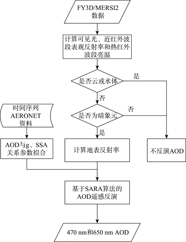
表1 MERSI2气溶胶反演主要波段光谱参数Tab. 1 MERSI2 channels used in AOD retrieval |
| 波段序号 | 中心波长/nm | 光谱带宽/nm | 空间分辨率/m | 主要用途 |
|---|---|---|---|---|
| 1 | 470 | 50 | 250 | 获取蓝波段大气辐射传输方程,云像元识别 |
| 3 | 650 | 50 | 250 | 获取红波段大气辐射传输方程 |
| 7 | 2130 | 50 | 1000 | 根据经验公式计算红、蓝波段地表反射率,水体和暗像元识别 |
| 25 | 12 000 | 1000 | 250 | 云像元识别 |
国家风云卫星遥感数据服务网为本研究提供了FY3D/MERSI2数据,AERONET和NASA提供了为本研究提供了CE318观测资料和MOD04数据下载服务,在此一并致谢。
| [1] |
苏城林, 苏林, 陈良富, 等. NPP VIIRS数据反演气溶胶光学厚度[J]. 遥感学报, 2015,19(6):977-989.
[
|
| [2] |
田信鹏, 孙林, 刘强, 等. 北京地区Landsat 8 OLI高空间分辨率气溶胶光学厚度反演[J]. 遥感学报, 2018,22(1):51-63.
[
|
| [3] |
|
| [4] |
|
| [5] |
|
| [6] |
|
| [7] |
陈辉, 厉青, 王中挺, 等. MERSI和MODIS卫星监测京津冀及周边地区PM2.5浓度[J]. 遥感学报, 2018,22(5):822-832.
[
|
| [8] |
张婕. 卫星气溶胶产品评估与融合改进及其在区域PM2.5浓度估算中的应用[D]. 兰州:兰州大学, 2016.
[
|
| [9] |
唐维尧, 鲍艳松, 张兴赢, 等. FY-3A/MERSI、MODIS C5.1和C6气溶胶光学厚度产品在中国区域与地面观测站点的对比分析[J]. 气象学报, 2018,76(3):449-460.
[
|
| [10] |
杨何群, 尹球, 周红妹, 等. 利用MATLAB实现FY-3/MERSI地表温度反演及专题制图[J]. 国土资源遥感, 2012,24(4):62-70.
[
|
| [11] |
|
| [12] |
|
| [13] |
朱爱军, 胡秀清, 林曼筠, 等. 风云三号D气象卫星全球数据获取方法及数据分发[J]. 海洋气象学报, 2018,38(3):1-10.
[
|
| [14] |
金诚. FY-3D卫星光谱成像仪陆上云检测算法研究[D]. 南京:南京信息工程大学, 2018.
[
|
| [15] |
张帅, 师春香, 梁晓, 等. 风云三号积雪覆盖产品评估[J]. 遥感技术与应用, 2018,33(1):35-46.
[
|
| [16] |
汪洋, 陈良富, 李莘莘, 等. 基于VIIRS数据的中国东部气溶胶光学厚度反演算法改进[J]. 地球物理学报, 2019,62(1):49-62.
[
|
| [17] |
刘方伟, 苏庆华, 孙林, 等. 基于Himwari-8卫星的沙尘监测[J]. 山东科技大学学报(自然科学版), 2018,37(3):11-19.
[
|
| [18] |
高大伟, 马浩, 郁珍艳, 等. 基于连续MODIS真彩图的霾监测预警新方法——以浙江省一次严重霾污染过程为例[J]. 中国环境科学, 2015,35(10):2939-2949.
[
|
/
| 〈 |
|
〉 |