
Journal of Geo-information Science >
The Spatio-temporal Characteristics of Tropical Cyclones Hazard in the Maritime Silk Road
Received date: 2019-07-22
Request revised date: 2019-11-17
Online published: 2021-02-25
Supported by
The Strategic Priority Research Program of Chinese Academy of Sciences(XDA20010302)
Copyright
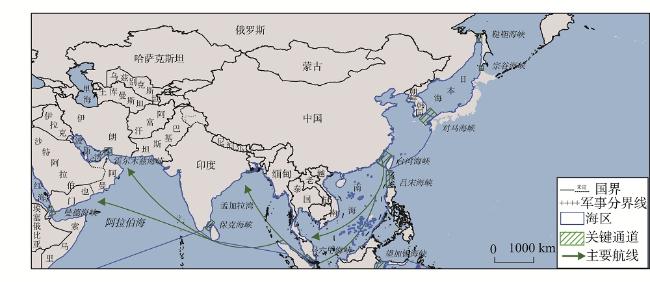
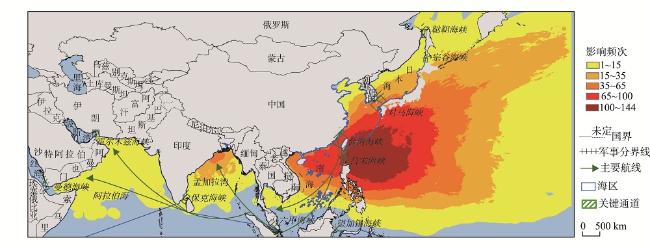
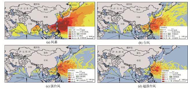
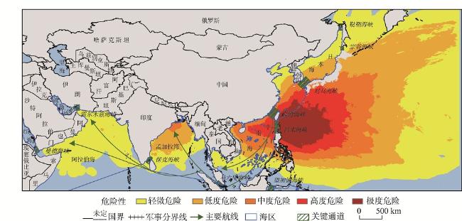
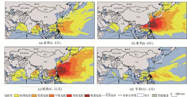
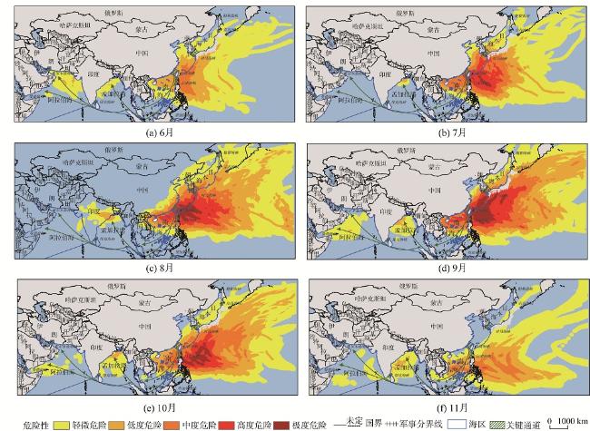
As a powerful meteorological disaster, tropical cyclones have a great impact on the maritime shipping of the Maritime Silk Road. Base on the best track data of tropical cyclones over the North Indian Ocean and the Northwest Pacific Ocean from 1990 to 2017, this paper analyzes the spatio-temporal characteristics of the tropicalcycloneshazard. First, the tropical cyclones are classified into 4 grades. Next, the Modified Rankine Vortex (MRV) model is used to simulate the wind field of each tropical cyclone. Then, the frequency of each grade of tropical cyclone that occurred in the research area can be obtained. Finally, a tropical cyclone hazard assessment model is used to assess the tropical cyclone hazard level in the main sea areas of the Maritime Silk Road.The main conclusions are as follows: (1) The sea areas of the Maritime Silk Road are seriously affected by tropical cycloneswith high occurrence frequency of tropical cyclones. The Northwest Pacific Ocean is more severely affected by tropical cyclones than the North Indian Ocean. (2)The sea areas between 15~30° North and 120~145° East are at the highest hazard level. (3) The seasonal change of tropical cyclone hazard is obvious. The tropical cyclone hazard levels of the sea areas of the North Indian Ocean and the Northwest Pacific Oceanare higher in autumn and summer than winter and spring. Moreover,in the summer and autumn, the sea areas in July, August, September and October have the relatively higher hazard levels. (4) Among the main sea areas, Eastern China Seais at the highest hazard level, followed by the South China Sea, the Sea of Japan, the Bay of Bengal, and the Arabian Sea, while the Red Sea and the Persian Gulf are not affected by tropical cyclones. Among the main channels, the Luzon Strait is at the highest hazard level, followed by the Taiwan Strait, the Tsushima Strait,the Soya Strait, the Tartar Strait, the Paco Strait, and the Strait of Hormuz, however the Strait of Malacca and the Strait of Mande are not affected by tropical cyclone.
XU Xinliang , SHEN Zhicheng , LI Jiahao , WANG Shikuan . The Spatio-temporal Characteristics of Tropical Cyclones Hazard in the Maritime Silk Road[J]. Journal of Geo-information Science, 2020 , 22(12) : 2383 -2392 . DOI: 10.12082/dqxxkx.2020.190369
表1 不同强度热带气旋等级划分Tab. 1 Tropical cyclone classification |
| 强度等级 | 等级类型 | 平均风速/(m/s) | 风力/级 |
|---|---|---|---|
| 1 | 风暴 | 17.2~32.6 | 8~11 |
| 2 | 台风 | 32.7~41.4 | 12~13 |
| 3 | 强台风 | 41.5~50.9 | 14~15 |
| 4 | 超强台风 | ≥ 51 | ≥ 16 |
表2 1990—2017年“海上丝绸之路”主要海区受热带气旋影响频次统计Tab. 2 Frequency of occurrence of tropical cyclone affecting the main sea areas of the Maritime Silk Road from 1990 to 2017 |
| 热带气旋类型 | 海区 | ||||||
|---|---|---|---|---|---|---|---|
| 日本海 | 中国东部海区 | 南海 | 孟加拉湾 | 阿拉伯海 | 波斯湾 | 红海 | |
| 风暴 | 105 | 105 | 171 | 92 | 31 | 0 | 0 |
| 台风 | 28 | 41 | 66 | 8 | 6 | 0 | 0 |
| 强台风 | 6 | 40 | 37 | 8 | 3 | 0 | 0 |
| 超强台风 | 1 | 56 | 21 | 7 | 3 | 0 | 0 |
| 合计 | 140 | 242 | 295 | 115 | 43 | 0 | 0 |
表3 1990—2017年“海上丝绸之路”主要海区热带气旋影响区域面积比例统计Tab. 3 Ratios of areas affected by tropical cyclones of the main sea areas of the Maritime Silk Road from 1990 to 2017 (%) |
| 热带气旋 类型 | 海区 | ||||
|---|---|---|---|---|---|
| 日本海 | 中国东部海区 | 南海 | 孟加拉湾 | 阿拉伯海 | |
| 风暴 | 100 | 98 | 74 | 69 | 66 |
| 台风 | 51 | 80 | 55 | 31 | 14 |
| 强台风 | 15 | 59 | 40 | 16 | 8 |
| 超强台风 | 100 | 38 | 19 | 7 | 2 |
| 总计 | 100 | 98 | 75 | 69 | 67 |
表4 1990—2017年“海上丝绸之路”关键通道热带气旋发生频次统计Tab. 4 Frequency of occurrence of tropical cyclones affecting the main channels of the Maritime Silk Road from 1990 to 2017 |
| 热带气旋类型 | 关键通道 | ||||||||
|---|---|---|---|---|---|---|---|---|---|
| 鞑靼海峡 | 宗谷海峡 | 对马海峡 | 台湾海峡 | 吕宋海峡 | 马六甲海峡 | 保克海峡 | 霍尔木兹海峡 | 曼德海峡 | |
| 风暴 | 3 | 16 | 60 | 80 | 119 | - | 8 | 1 | - |
| 台风 | - | 1 | 13 | 31 | 28 | - | 3 | - | - |
| 强台风 | - | 1 | 9 | 15 | 15 | - | - | - | - |
| 超强台风 | - | - | 5 | 5 | 12 | - | - | - | - |
| 合计 | 3 | 18 | 87 | 131 | 174 | - | 11 | 1 | - |
表5 “海上丝绸之路”主要海区不同级别热带气旋危险性区域面积占比统计Tab. 5 The proportion of tropical cyclone hazard areas in main sea areas of the Maritime Silk Road (%) |
| 热带气旋危险性 | 日本海 | 中国东部海区 | 南海 | 孟加拉湾 | 阿拉伯海 |
|---|---|---|---|---|---|
| 轻微危险 | 54 | 25 | 24 | 35 | 67 |
| 低度危险 | 43 | 15 | 13 | 30 | 0 |
| 中度危险 | 3 | 22 | 24 | 3 | 0 |
| 高度危险 | 0 | 23 | 14 | 0 | 0 |
| 极度危险 | 0 | 13 | 0 | 0 | 0 |
图5 1990—2017年“海上丝绸之路”主要海域不同季节热带气旋危险性分布注:该图基于自然资源部标准地图服务网站下载的审图号为GS(2016)1667号的标准地图制作,底图无修改。 Fig. 5 Distribution of tropical cyclones hazard in different seasons in the main sea areas of the Maritime Silk Road from 1990 to 2017 |
表6 1990—2017年“海上丝绸之路”关键通道不同季节热带气旋危险性状态Tab. 6 Tropical cyclones hazard levels of main channels of the Maritime Silk Road from 1990 to 2017 |
| 季节 | 鞑靼海峡 | 宗谷海峡 | 对马海峡 | 台湾海峡 | 吕宋海峡 | 马六甲海峡 | 保克海峡 | 霍尔木兹海峡 | 曼德海峡 |
|---|---|---|---|---|---|---|---|---|---|
| 春 | - | - | - | 轻微危险 | 中度危险 | - | 轻微危险 | - | - |
| 夏 | 轻微危险 | 轻微危险 | 中度危险 | 高度危险 | 极度危险 | - | - | 轻度危险 | - |
| 秋 | 轻微危险 | 轻微危险 | 中度危险 | 中度危险 | 高度危险 | - | 轻微危险 | - | - |
| 冬 | - | - | - | - | - | - | 轻微危险 | - | - |
| [1] |
杜德斌, 马亚华. “一带一路”:中华民族复兴的地缘大战略[J]. 地理研究, 2015,34(6):1005-1014.
[
|
| [2] |
王列辉, 朱艳. 基于“21世纪海上丝绸之路”的中国国际航运网络演化[J]. 地理学报, 2017,72(12):2265-2280.
[
|
| [3] |
方志祥, 余红楚, 黄守倩. 海洋运输网络研究进展与趋势探讨[J]. 地球信息科学学报, 2018,20(5):554-563.
[
|
| [4] |
黄彬, 刘还珠, 何金海, 等. 影响冬季北太平洋航线设计的天气要素的分析[J]. 应用气象学报, 2003,14(1):101-108.
[
|
| [5] |
杨腾飞, 解吉波, 李振宇, 等. 微博中蕴含台风灾害损失信息识别和分类方法[J]. 地球信息科学学报, 2018,20(7):906-917.
[
|
| [6] |
吴迪, 王诺, 于安琪, 等. “丝路”海运网络的脆弱性及风险控制研究[J]. 地理学报, 2018,73(6):1133-1148.
[
|
| [7] |
刘哲, 张鹏, 刘南江, 等. “一带一路”中国重点区域自然灾害特征分析[J]. 灾害学, 2018,33(4):65-71.
[
|
| [8] |
许世远, 王军, 石纯, 等. 沿海城市自然灾害风险研究[J]. 地理学报, 2006,61(2):127-138.
[
|
| [9] |
陈文方, 端义宏, 陆逸, 等. 热带气旋灾害风险评估现状综述[J]. 灾害学, 2017,32(4):146-152.
[
|
| [10] |
欧进萍, 段忠东, 常亮. 中国东南沿海重点城市台风危险性分析[J]. 自然灾害学报, 2002,11(4):9-17.
[
|
| [11] |
李倩, 俞海洋, 李婷, 等. 京津冀地区台风危险性评估—基于Gumbel分布的分析[J]. 地理科学进展, 2018,37(7):933-945.
[
|
| [12] |
殷洁, 戴尔阜, 吴绍洪. 中国台风灾害综合风险评估与区划[J]. 地理科学, 2013,33(11):1370-1376.
[
|
| [13] |
|
| [14] |
|
| [15] |
王宁娟. 基于CE风场数值模拟的台风危险性分析方法研究[D]. 哈尔滨:哈尔滨工业大学, 2013.
[
|
| [16] |
|
| [17] |
尹宜舟, 黄建斌, 朱志存, 等. 我国沿海主要省份热带气旋风雨因子危险性分析Ⅱ:年代际变化特征[J]. 热带气象学报, 2018,34(2):153-161.
[
|
| [18] |
|
| [19] |
|
| [20] |
殷洁, 戴尔阜, 吴绍洪, 等. 中国台风强度等级与可能灾害损失标准研究[J]. 地理研究, 2013,32(2):266-274.
[
|
| [21] |
中华人民共和国海事局. 国内航行海船法定检验技术规则[M]. 北京: 人民交通出版社, 2011.
[ China MSA. Legal technical rules for the inspection of seagoing vessels in China[M]. Beijing: China Communications Press, 2011. ]
|
| [22] |
中国国家标准化管理委员会. 热带气旋等级(GB/T 19201-2006)[S]. 北京: 中国质检出版社, 2014.
[ China national standardization management committee. Grade of tropical cyclones(GB/T 19201-2006)[S]. Beijing: China Quality Press, 2014. ]
|
| [23] |
|
| [24] |
|
| [25] |
|
| [26] |
|
/
| 〈 |
|
〉 |