
Journal of Geo-information Science >
Monitoring Ground Subsidence in High-intensity Mining Area by Integrating DInSAR and Offset-tracking Technology
Received date: 2019-12-02
Request revised date: 2020-04-13
Online published: 2021-02-25
Supported by
National Natural Science Foundation of China(41701515)
National Natural Science Foundation of China and the Shenhua Coal Industry Group Company Limited(U1261106)
National Natural Science Foundation of China and the Shenhua Coal Industry Group Company Limited(U1261206)
State Key Laboratory of Earthquake Dynamics(LED2018B04)
National Natural Science Foundation of Jiangsu Province(BK20170379)
Copyright
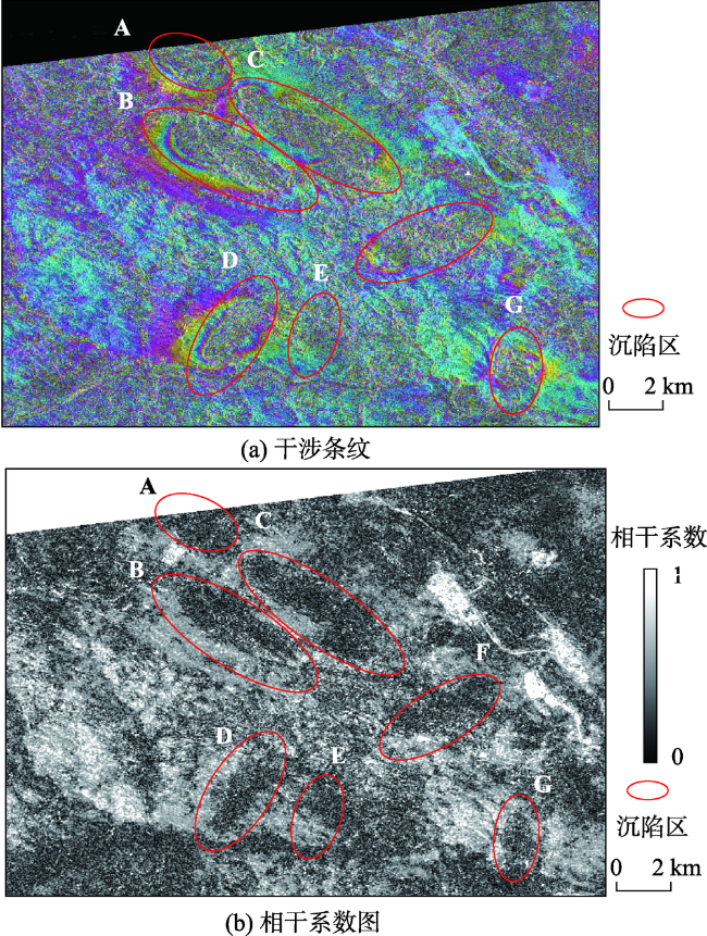
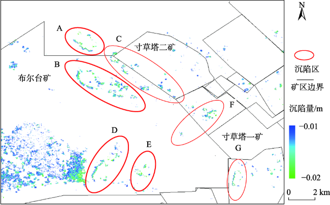
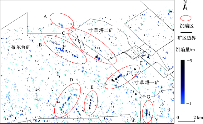
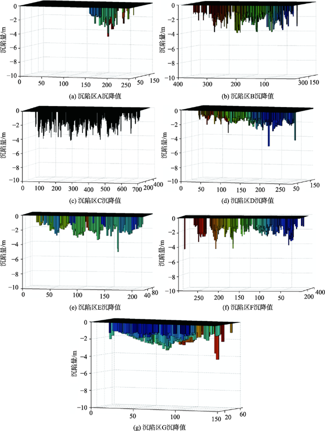
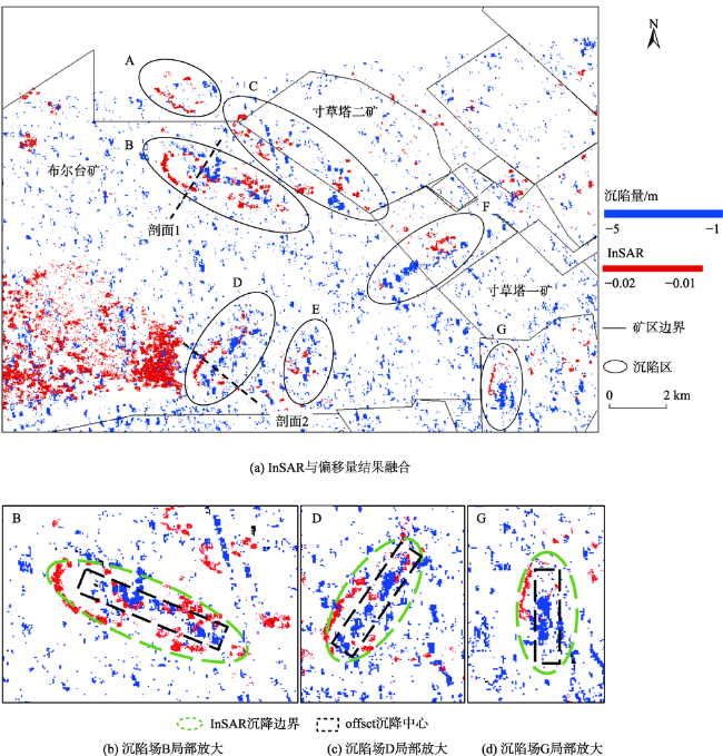
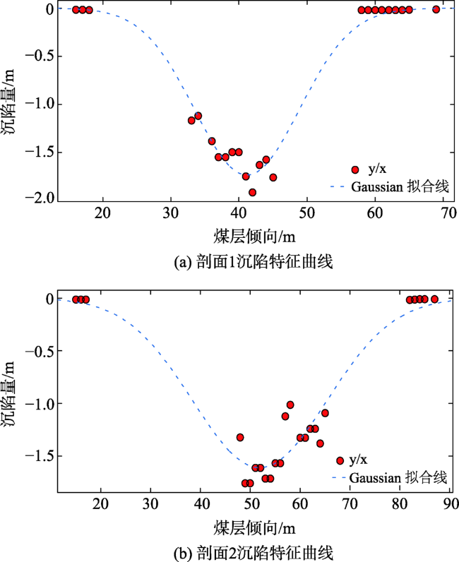
High-intensity underground mining leads to huge surface deformation, and excessive deformation phase gradients could lead to interference unwrapping errors. Currently, the characteristics of surface subsidence cannot be obtained well by conventional DInSAR and its derivative technologies. In this paper, we propose a new method, which combines DInSAR and Offset-tracking technology to extract large-scale deformation accurately, and further restore settlement field shape using the GAUSS function model. We take Bu'ertai Mine, and Cuncaota No.1 and No.2 Mine in Shendong Mining Area as research areas and use the high-resolution RADARSAT-2 data with 5 m fine beam model (MF5) on February 13, 2012 and November 27, 2012 to obtain the mine subsidence boundaries at sub-centimeter level using DInSAR technology and the mine subsidence center at meter level using Offset-tracking method. The boundary subsidence value is -0.01~ -0.02 m and the central subsidence value is -1.0~ -4.0 m. The whole subsidence field is then retrieved by integrating above two results. Finally, the GAUSS function model is used to fit the mining subsidence boundary and central, and to reconstruct the characteristic curve of mining subsidence. Our results demonstrate that the Offset-tracking method could compensate the deficiency of DInSAR in large deformation extraction, and the combination of these two techniques could effectively and accurately extract large-scale subsidence field in mining areas.
XU Xiaobo , MA Chao , SHAN Xinjian , LIAN Dajun , QU Chunyan , BAI Junwu . Monitoring Ground Subsidence in High-intensity Mining Area by Integrating DInSAR and Offset-tracking Technology[J]. Journal of Geo-information Science, 2020 , 22(12) : 2425 -2435 . DOI: 10.12082/dqxxkx.2020.190741
表1 实验区RADARSAT-2数据基本信息Tab.1 Imaging parameters and geometry of RADARSAT-2 data |
| 编号 | 获取时间 | 像元大小/m (距离×方位) | 时间基线 /d | 垂直基线 /m |
|---|---|---|---|---|
| 1 | 2012-02-13 | 2.7×2.9 | 289 | 27.98 |
| 2 | 2012-11-27 | 2.7×2.9 |
| [1] |
郭文兵, 王云广. 基于绿色开采的高强度开采定义及其指标体系研究[J]. 采矿与安全工程学报, 2017,34(4):616-623.
[
|
| [2] |
郭文兵, 白二虎, 杨达明. 煤矿厚煤层高强度开采技术特征及指标研究[J]. 煤炭学报, 2018,43(8):2117-2125.
[
|
| [3] |
马雯思, 马超, 刘玮. 陕西彬长矿区NDVI3g(1982-2013)变化趋势及气候响应[J]. 煤炭学报, 2019,44(4):1197-1206.
[
|
| [4] |
马超, 徐小波, 刘春国, 等. 高分辨率星载SAR矿区灾害监测的应用潜力[J]. 河南理工大学学报(自然科学版), 2011,30(6):684-689.
[
|
| [5] |
|
| [6] |
|
| [7] |
屈春燕, 左荣虎, 单新建, 等. 尼泊尔Mw 7.8地震InSAR同震形变场及断层滑动分布[J]. 地球物理学报, 2017,60(1):151-162.
[
|
| [8] |
朱建军, 邢学敏, 胡俊, 等. 利用InSAR技术监测矿区地表形变[J]. 中国有色金属学报, 2011,21(10):2564-2576.
[
|
| [9] |
邓喀中, 姚宁, 卢正, 等. D-InSAR监测开采沉陷的实验研究[J]. 金属矿山, 2009,39(12):25-27.
[
|
| [10] |
吴立新, 高均海, 葛大庆, 等. 基于D-InSAR的煤矿区开采沉陷遥感监测技术分析[J]. 地理与地理信息科学, 2004,20(3):22-25.
[
|
| [11] |
黄继磊. 面向矿区大梯度形变监测的SAR影像Pixel-tracking关键问题研究[D]. 徐州:中国矿业大学, 2017.
[
|
| [12] |
|
| [13] |
|
| [14] |
刘志敏, 李永生, 张景发, 等. 基于SBAS_InSAR的长治矿区地表形变监测[J]. 国土资源遥感, 2014,26(3):37-42.
[
|
| [15] |
李国华, 薛继群. 基于短基线集技术的矿区开采沉陷监测研究[J]. 测绘与空间地理信息, 2013,36(3):191-196.
[
|
| [16] |
尹洪杰, 朱建军, 李志伟, 等. 基于SBAS的矿区形变监测研究[J]. 测绘学报, 2011,40(1):52-58.
[
|
| [17] |
葛大庆, 王艳, 郭小方, 等. 利用短基线差分干涉纹图集监测地表形变场[J]. 大地测量与地球动力学, 2008,28(2):61-66.
[
|
| [18] |
|
| [19] |
刘国祥, 陈强, 罗小军. 永久散射体雷达干涉理论与应用[M]. 北京: 科学出版社, 2012.
[
|
| [20] |
范洪冬, 邓喀中, 薛继群, 等. 利用时序SAR影像集监测开采沉陷的试验研究[J]. 煤矿安全, 2011,42(2):15-18.
[
|
| [21] |
|
| [22] |
|
| [23] |
|
| [24] |
成晓倩, 马超, 康建荣, 等. 联合DInSAR和PIM技术的沉陷特征模拟和时序分析[J]. 中国矿业大学学报, 2018,47(5):1141-1148.
[
|
| [25] |
徐小波, 屈春燕, 单新建, 等. CR-InSAR与PS-InSAR联合解算方法及在西秦岭断裂中段缓慢变形研究中的应用[J]. 地球物理学报, 2016,59(8):2796-2805.
[
|
| [26] |
|
| [27] |
陈俊杰, 南华, 闫伟涛, 等. 浅埋深高强度开采地表动态移动变形特征[J]. 煤炭科学技术, 2016,44(3):158-162.
[
|
| [28] |
伊茂森. 神东矿区浅埋煤层关键层理论及其应用研究[D]. 徐州:中国矿业大学, 2008.
[
|
| [29] |
周秀隆, 吴嘉林, 辛德林. 世界第一矿——布尔台煤矿设计综述[J]. 煤炭工程, 2011(3):4-6.
[
|
| [30] |
马超, 孟秀军, 潘进波, 等. D_InSAR时序开采沉陷观测的干涉策略选优[J]. 河南理工大学学报(自然科学版), 2012,31(3):311-316.
[
|
| [31] |
何国清. 矿山开采沉陷学[M]. 徐州: 中国矿业大学出版社, 1999.
[
|
| [32] |
王军, 赵欢欢, 杨小敏, 等. 鄂尔多斯神东矿区开采地表沉陷预测模型研究[J]. 内蒙古农业大学学报(自然科学版), 2015,36(4):61-65.
[
|
| [33] |
|
/
| 〈 |
|
〉 |


