
Journal of Geo-information Science >
The Spatial Distribution Pattern of Rock in Rocky Desertification Area based on Unmanned Aerial Vehicle Imagery and Object-oriented Classification Method
Received date: 2019-12-02
Request revised date: 2020-03-02
Online published: 2021-02-25
Supported by
National Key R&D Program of China(2016YFC0502400)
National Key Research and Development Program(41501478)
Copyright
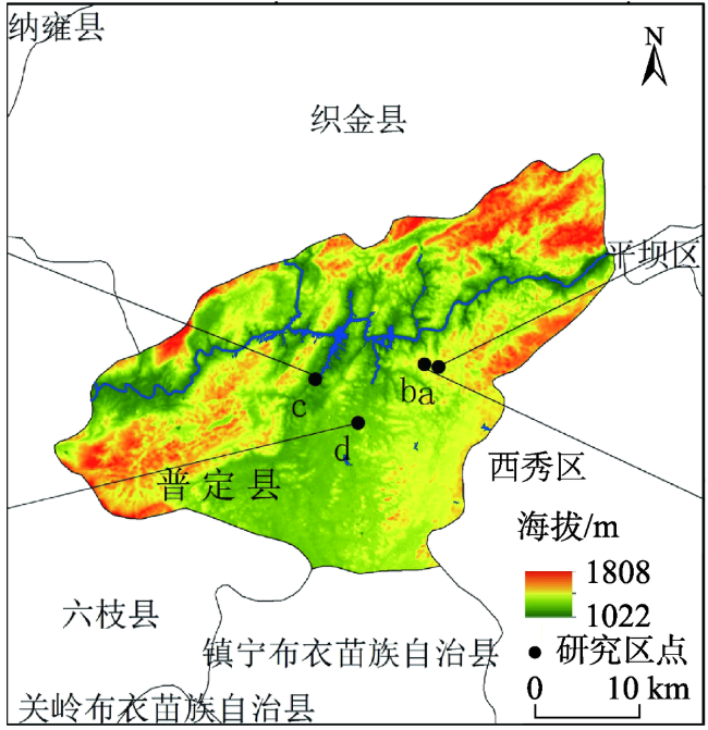
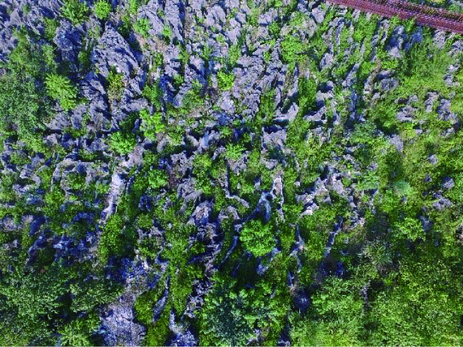
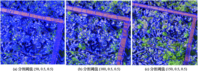
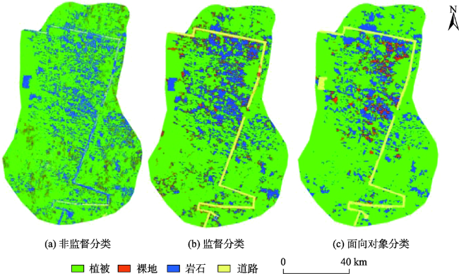
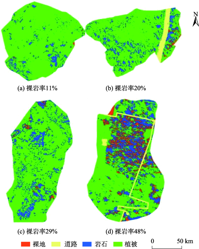
The change of landscape pattern has an important influence on the material and energy flows of ecological environment. Quantifying the landscape pattern of rocky desertification in a karst area is very important for understanding the development of rocky desertification. Rocky desertification is a dynamic land degradation process, which is a comprehensive reflection of vegetation, bedrock, soil cover, and other surface factors. Particularly, exposed bedrock acts as a key indicator of karst rocky desertification. In this study, spatial distribution of rock patches with varied bare-rock ratio (11%, 20%, 29%, and 48%) is characterized using an Unmanned Aerial Vehicle (UAV) image in a rocky desertification area in Guizhou Province. The classification methods for this small-scale UAV image include unsupervised classification, supervised classification, and object-oriented classification. The existing supervised and unsupervised classification methods based on pixels cannot meet the requirements of accurate extraction of rocky desertification information in karst rocky desertification area with complex geological environment. So an optimal classification method is selected to classify the UAV image of rocky desertification in our study. Our results show that the object-oriented classification method has higher accuracy than the others, which reduces the “salt-and-pepper phenomenon” caused by complicated topography. Based on object-oriented classification, the UAV image is interpreted first, and the distribution characteristics of rock patches with different bare-rock rates (i.e., 11%, 20%, 29% and 48%) are quantified by combining various indices in landscape ecology including landscape patch index, landscape shape index, and landscape fragmentation index. Generally, the average patch area of rock is negatively correlated with bare-rock rate. With the increase of bare-rock rate in different rocky desertification areas, the number of rock patches gradually increase with increasing rock shape index and rock fragmentation index, which indicates the increase of rocky desertification. The exposed bare rocks in this karst area show different distribution patterns and characteristics under different rocky desertification rates. The higher the rate of bare rock is, the higher the degree of rock fragmentation is, with a relatively scattering distribution of rock patches. Analyzing the rock distribution for a rocky desertification area can provide support for the evaluation and management of rocky desertification areas. Since the changes of small-scale, small-patch landscape pattern in rocky desertification areas can affect the ecological processes, our small-scale study also provides better understanding of future processes of rocky desertification and the development of rocky desertification at regional scale.
ZHANG Zhihui , LIU Wen , LI Xiaohan , ZHU Jingxuan , ZHANG Hongtao , YANG Dong , XU Chaohao , XU Xianli . The Spatial Distribution Pattern of Rock in Rocky Desertification Area based on Unmanned Aerial Vehicle Imagery and Object-oriented Classification Method[J]. Journal of Geo-information Science, 2020 , 22(12) : 2436 -2444 . DOI: 10.12082/dqxxkx.2020.190744
表1 3种不同分类方法计算精度评价结果对比Tab. 1 Summary of accuracy evaluation results of three different classification methods |
| ISODATA方法 | 最大似然法 | 面向对象法/% | |||||||||||||
|---|---|---|---|---|---|---|---|---|---|---|---|---|---|---|---|
| PA | UA | OA | K | PA | UA | OA | K | PA | UA | OA | K | ||||
| 植被 | 64.29 | 99.22 | 62.64 | 0.27 | 99.06 | 100 | 97.93 | 0.92 | 97.30 | 100 | 98.81 | 0.98 | |||
| 岩石 | 88.79 | 16.79 | 94.35 | 80.42 | 99.33 | 98.03 | |||||||||
| 裸地 | 6.51 | 0.61 | 93.04 | 59.51 | 99.71 | 99.16 | |||||||||
| 建筑 | 43.78 | 62.29 | 89.79 | 97.64 | 99.16 | 100 | |||||||||
注:PA表示制图精度;UA表示用户精度;OA表示总体精度;K表示Kappa系数。 |
表2 4个研究区图不同裸岩率统计数值Tab. 2 Four graph statistics of different bare rock rate in research areas |
| 研究区a | 研究区b | 研究区c | 研究区d | |
|---|---|---|---|---|
| 岩石面积/m2 | 1367.97 | 648.21 | 2616.41 | 4173.14 |
| 总面积/m2 | 12 394.48 | 3260.91 | 10 785.20 | 8724.89 |
| 裸岩率/% | 11 | 20 | 29 | 48 |
表3 景观类型指数斑块统计值Tab. 3 statistics results of landscape metrics on landscape elements |
| 类型 | 裸岩率11% | 裸岩率20% | 裸岩率29% | 裸岩率48% |
|---|---|---|---|---|
| NP/个 | 256 | 324 | 867 | 1401 |
| MPS/m2 | 2.08 | 2.84 | 3.02 | 1.26 |
| PSSD | 2.87 | 4.53 | 4.54 | 2.54 |
| AWMSI | 4.66 | 4.57 | 3.32 | 4.98 |
| AWMPFD | 1.98 | 1.94 | 2.00 | 1.83 |
| Cs | 4.10 | 3.83 | 3.88 | 6.95 |
| Cv | 1.37 | 1.60 | 1.47 | 2.45 |
| CONTIG | 0.17 | 0.29 | 0.38 | 0.28 |
| MSI | 3.40 | 3.30 | 2.46 | 3.57 |
| MPE | 30.14 | 39.54 | 25.03 | 13.30 |
| MPFD | 1.79 | 1.86 | 1.60 | 1.31 |
| TED | 5.66 | 4.99 | 9.55 | 10.54 |
| CONTAG | 69.54 | 60.01 | 51.86 | 27.55 |
| F | 0.000 001 | 0.000 61 | 0.000 81 | 0.000 90 |
| [1] |
王世杰, 李阳兵. 喀斯特石漠化研究存在的问题与发展趋势[J]. 地球科学进展, 2007,22(6):573-582.
[
|
| [2] |
|
| [3] |
顾磊, 江晓霞, 陈智华. 生态学空间异质性研究进展[J]. 西南民族大学学报(自然科学版), 2005(s1):6-10.
[
|
| [4] |
|
| [5] |
王梦娟. 基于多源遥感数据的岩溶石漠化信息提取研究[D]. 兰州:兰州理工大学, 2019.
[
|
| [6] |
刘凯, 龚辉, 曹晶晶, 等. 基于多类型无人机数据的红树林遥感分类对比[J]. 热带地理, 2019,39(4):492-501.
[
|
| [7] |
黄超, 吴琳娜, 宋具兰, 等. 遥感图像监督分类与面向对象分类法对比研究[J]. 农村经济与科技, 2016(23):66-68.
[
|
| [8] |
|
| [9] |
余晓敏, 湛飞并, 廖明生, 等. 利用改进SEaTH算法的面向对象分类特征选择方法[J]. 武汉大学学报·信息科学版, 2012,37(8):921-924.
[
|
| [10] |
|
| [11] |
孙小芳, 卢健, 孙小丹. 城市地区高分辨率遥感影像绿地提取研究[J]. 遥感技术与应用, 2006(2):159-162.
[
|
| [12] |
毛学刚, 姚瑶, 陈树新, 等. 基于易康软件的QuickBird遥感影像林分类型识别——以福建省将乐林场为例[J]. 南京林业大学学报(自然科学版), 2019,43(1):127-134.
[
|
| [13] |
闫丽. 奈曼旗沙质草地岩石—裸沙动态特征研究[D]. 呼和浩特:内蒙古师范大学, 2010.
[
|
| [14] |
|
| [15] |
|
| [16] |
傅伯杰, 陈利顶. 景观生态学原理及应用[M]. 北京: 科学出版社, 2001: 45-48.
[
|
| [17] |
方晰, 唐代生, 杨乐, 等. 湖南省林科院试验林场森林植被景观格局及破碎化分析[J]. 中南林业科技大学学报, 2008(4):107-112.
[
|
| [18] |
|
| [19] |
李哈滨, 伍业钢. 景观生态学的定量方法[C]. 北京: 中国科技出版社, 1992: 209-233.
[
|
| [20] |
李斌, 张金屯. 黄土高原草原景观斑块形状的指数和分形分析[J]. 草地学报, 2010,18(2):141-147.
[
|
| [21] |
贾宝全, 王国柱, 慈龙骏. 景观格局分布特征的区域差异分析——以鄂尔多斯高原伊金霍洛旗为例[J]. 干旱区研究, 2003,20(3):168-174.
[
|
| [22] |
牟晓明, 于应文, 王先之. 青藏高原火绒草斑块群落空间格局分析[J]. 生态学报, 2015,35(16):5306-5315.
[
|
/
| 〈 |
|
〉 |