
Journal of Geo-information Science >
Vegetation Mapping in Taibai Mountain Area Supported by LSTM with Time Series Sentinel-1A Data
Received date: 2020-06-30
Request revised date: 2020-09-15
Online published: 2021-02-25
Supported by
National Key Research and Development Program(2019YFC1804301)
Fundamental Research Funds for the Central Universities(B200202008)
Open Fund of State Key Laboratory of Remote Sensing Science(OFSLRSS201919)
Opening Foundation of Key Lab of Spatial Data Mining & Information Sharing, Ministry of Education (Fuzhou University)(2019LSDMIS04)
Copyright
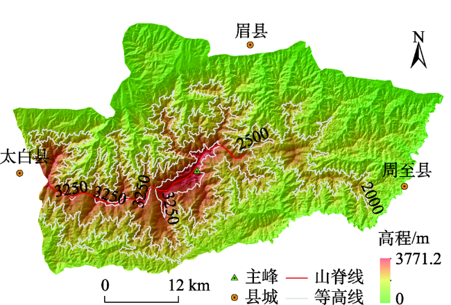
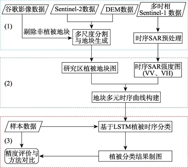
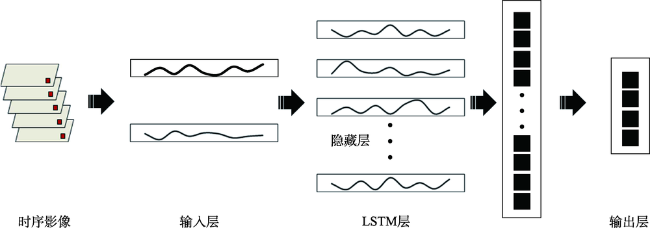
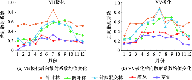
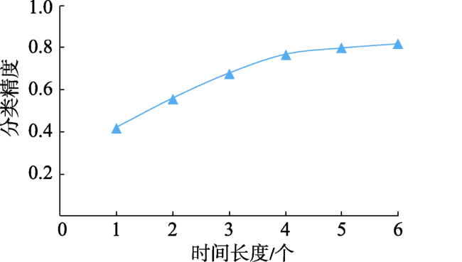
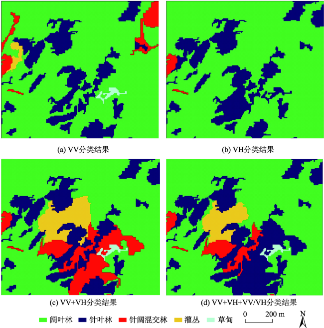
Vegetation classification is the basis and premise of forest resource investigation and dynamic monitoring. Remote sensing techniques have long been important means of forest monitoring with their ability to quickly and efficiently collect the spatial-temporal variability of vegetation. Vegetation classification is a key issue for forest monitoring and is critical to many remote sensing applications in the domain of precision forestry such as vegetation area estimation. Remote sensing applications in vegetation classification have traditionally focused on the use of optical data such as MODIS. However, due to cloud and haze interference, optical images are not always available at phenological stages that are essential to vegetation identification, making it difficult to construct complete time-series vegetation growth and limiting the vegetation classification accuracy. Unlike passive visible and infrared wavelengths which are sensitive to cloud and light, active SAR (Synthetic Aperture Radar) is particularly attractive for vegetation classification due to its all-weather, all-day imaging capabilities. In addition, SAR provides information on the stem and leaf structures of vegetation and is sensitive to soil roughness and moisture content, making it effective in forest applications. In this study, a deep-learning-based time-series analysis method employing multi-temporal SAR data is presented for forest vegetation classification in the Taibai Mountain (the main peak of Qinling Mountains). Firstly, Sentinel-2 optical images and digital elevation data in the study area were used for multi-scale segmentation to produce a precise farmland map. Then pre-processed SAR intensity images were overlaid with the farmland map to construct time-series vegetation growth for each parcel. Finally, a deep-learning-based classifier using the Long Short-Term Memory (LSTM) network was employed to learn time-series features of vegetation and to classify parcels to produce a final classification map. The experimental results show that: (1) Compared with traditional machine learning methods (such as Random Forest and Support Vector Machine), the classification accuracy of the deep-learning-based method proposed in this paper was improved by more than 10%; (2) Among different combinations of Sentinel-1A polarizations, VV+VH performed best, having a similar accuracy with the VV+VH+VV/VH; (3) Time-series classification using all images in the whole year achieved the best performance, with an overall accuracy of 82% using VV+VH. The study shows that the combination LSTM network and time-series Sentinel-1A data can effectively improve the accuracy of vegetation classification and provide new ideas for forest vegetation classification from the perspectives of data source and classification method.
YANG Dan , ZHOU Yanan , YANG Xianzeng , GAO Lijing , FENG Li . Vegetation Mapping in Taibai Mountain Area Supported by LSTM with Time Series Sentinel-1A Data[J]. Journal of Geo-information Science, 2020 , 22(12) : 2445 -2455 . DOI: 10.12082/dqxxkx.2020.200338
表1 Sentinel-1A SAR数据列表Tab. 1 List of Sentinel-1A images |
| 序号 | 影像获取时间 | 极化方式 | 空间分辨率 | 序号 | 影像获取时间 | 极化方式 | 空间分辨率 |
|---|---|---|---|---|---|---|---|
| D1 | 2018-01-11 | VV+VH | 5 m×20 m | D16 | 2018-07-10 | VV+VH | 5 m×20 m |
| D2 | 2018-01-23 | D17 | 2018-07-22 | ||||
| D3 | 2018-02-04 | D18 | 2018-08-03 | ||||
| D4 | 2018-02-16 | D19 | 2018-0815 | ||||
| D5 | 2018-02-28 | D20 | 2018-08-27 | ||||
| D6 | 2018-03-12 | D21 | 2018-09-08 | ||||
| D7 | 2018-03-24 | D22 | 2018-09-20 | ||||
| D8 | 2018-04-05 | D23 | 2018-10-02 | ||||
| D9 | 2018-04-17 | D24 | 2018-10-14 | ||||
| D10 | 2018-04-29 | D25 | 2018-10-26 | ||||
| D11 | 2018-05-11 | D26 | 2018-11-07 | ||||
| D12 | 2018-05-23 | D27 | 2018-11-19 | ||||
| D13 | 2018-06-04 | D28 | 2018-12-01 | ||||
| D14 | 2018-06-16 | D29 | 2018-12-13 | ||||
| D15 | 2018-06-28 | D30 | 2018-12-25 |
表2 Sentinel-2波段信息Tab. 2 Band information of Sentinel-2 |
| 波段 | 波段宽度/nm | 中心波长/nm | 空间分辨率/m |
|---|---|---|---|
| B2 | 65 | 490 | 10 |
| B3 | 35 | 560 | 10 |
| B4 | 30 | 665 | 10 |
| B8 | 115 | 842 | 10 |
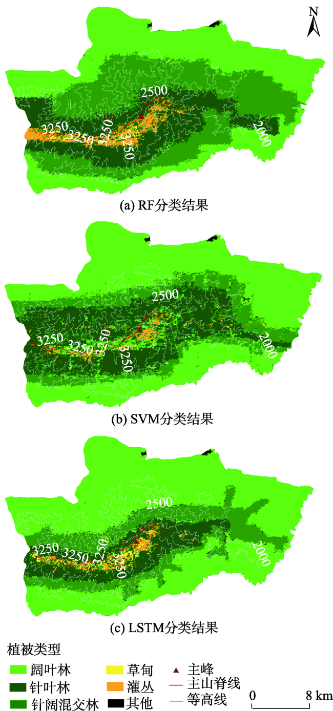
表3 RF、SVM与LSTM3种分类方法的精度评价Tab. 3 Classification performance using the SVM, RF, and LSTM-based three different classifiers (%) |
| 类别 | SVM | RF | LSTM | ||||||
|---|---|---|---|---|---|---|---|---|---|
| UA | PA | F1 | UA | PA | F1 | UA | PA | F1 | |
| 阔叶林 | 68.75 | 72.24 | 70.45 | 69.43 | 75.24 | 72.22 | 83.53 | 84.67 | 84.10 |
| 针叶林 | 66.32 | 67.43 | 66.87 | 71.18 | 74.14 | 72.63 | 84.31 | 82.59 | 83.44 |
| 针阔混交林 | 64.03 | 63.45 | 63.74 | 65.29 | 73.34 | 69.08 | 80.04 | 81.27 | 80.65 |
| 灌丛 | 65.14 | 62.78 | 63.94 | 68.25 | 68.74 | 68.49 | 81.14 | 78.96 | 80.04 |
| 草甸 | 64.91 | 62.36 | 63.61 | 67.74 | 69.37 | 68.55 | 79.46 | 79.35 | 79.40 |
| 总体精度 | 65.57 | 71.39 | 82.45 | ||||||
| Kappa系数 | 61.34 | 69.58 | 80.01 | ||||||
表4 不同时间序列长度信息列表Tab. 4 Information of different time series |
| 时间长度/个 | 影像日期 | 影像数量/景 |
|---|---|---|
| 1 | 01-11—02-28 | 5 |
| 2 | 01-11—04-29 | 10 |
| 3 | 01-11—06-28 | 15 |
| 4 | 01-11—08-27 | 20 |
| 5 | 01-11—10-26 | 25 |
| 6 | 01-11—12-25 | 30 |
表5 不同极化特征组合参与LSTM分类精度对比表Tab. 5 Comparison of overall accuracy values using different feature combinations based on LSTM classfier |
| VV | VH | VV+VH | VV+VH+VV/VH | |
|---|---|---|---|---|
| 总体精度 | 64.25 | 53.37 | 82.45 | 81.36 |
| Kappa系数 | 61.31 | 50.25 | 80.01 | 79.03 |
| [1] |
朱晓勤, 刘康, 李建国, 等. GIS支持下的秦岭山地植被分布与环境梯度关系研究[J]. 水土保持研究, 2009,16(2):169-175.
[
|
| [2] |
竺可桢. 中国的亚热带[J]. 科学通报, 1958(17):524-528.
[
|
| [3] |
张百平. 中国南北过渡带研究的十大科学问题[J]. 地理科学进展, 2019,38(3):305-311.
[
|
| [4] |
崔一娇, 朱琳, 赵力娟. 基于面向对象及光谱特征的植被信息提取与分析[J]. 生态学报, 2013,33(3):867-875.
[
|
| [5] |
贾明明, 任春颖, 刘殿伟, 等. 基于环境星与MODIS时序数据的面向对象森林植被分类[J]. 生态学报, 2014,34(24):7167-7174.
[
|
| [6] |
杨存建, 周其林, 任小兰, 等. 基于多时相MODIS数据的四川省森林植被类型信息提取[J]. 自然资源学报, 2014,29(3):507-515.
[
|
| [7] |
胡秀娟, 徐涵秋, 黄绍霖, 等. WorldView-2近红外光谱波段反演马尾松植被信息的比较研究[J]. 地球信息科学学报, 2016,18(4):537-543.
[
|
| [8] |
李丹, 柯樱海, 宫辉力, 等. 基于高分辨率遥感影像的城市典型乔木树种分类研究[J]. 地理与地理信息科学, 2016,32(1):84-89,127.
[
|
| [9] |
张俊瑶, 姚永慧, 索南东主, 等. 基于垂直带谱的太白山区山地植被遥感信息提取[J]. 地理信息科学学报, 2019,21(8):1284-1294.
[
|
| [10] |
别强, 何磊, 赵传燕. 基于影像融合和面向对象技术的植被信息提取研究[J]. 遥感技术与应用, 2014,29(1):164-171.
[
|
| [11] |
|
| [12] |
|
| [13] |
冯莉, 李柳华, 郭松, 等. HJ-1A NDVI与MODIS NDVI时间序列提取植被物候特征对比研究[J]. 遥感技术与应用, 2016,31(6):1158-1166.
[
|
| [14] |
郭文婷, 张晓丽. 基于Sentinel-2时序多特征的植被分类[J]. 浙江农林大学学报, 2019,36(5):849-856.
[
|
| [15] |
郝莹莹, 罗小波, 仲波, 等. 基于植被分区的中国植被类型分类方法[J]. 遥感技术与应用, 2017,32(2):315-323.
[
|
| [16] |
|
| [17] |
|
| [18] |
|
| [19] |
|
| [20] |
|
| [21] |
|
| [22] |
|
| [23] |
|
| [24] |
|
| [25] |
|
| [26] |
|
| [27] |
|
| [28] |
|
| [29] |
|
| [30] |
|
| [31] |
曹林林, 李海涛, 韩颜顺, 等. 卷积神经网络在高分遥感影像分类中的应用[J]. 测绘科学, 2016,41(9):170-175.
[
|
| [32] |
刘浩, 骆剑承, 黄波, 等. 基于特征压缩激活Unet网络的建筑物提取[J]. 地球信息科学学报, 2019,21(11):1779-1789.
[
|
| [33] |
吴田军, 骆剑承, 夏列钢, 等. 迁移学习支持下的遥感影像对象级分类样本自动选择方法[J]. 测绘学报, 2014,43(9):908-916.
[
|
| [34] |
|
| [35] |
|
| [36] |
|
| [37] |
|
| [38] |
|
/
| 〈 |
|
〉 |