
Journal of Geo-information Science >
Development and Prospect of GIS Platform Software Technology System
Received date: 2021-01-01
Revised date: 2021-01-18
Online published: 2021-03-25
Supported by
National Key Research and Development Program of China(2018YFB2100700)
National Key Research and Development Program of China(2017YFD0300403)
Copyright
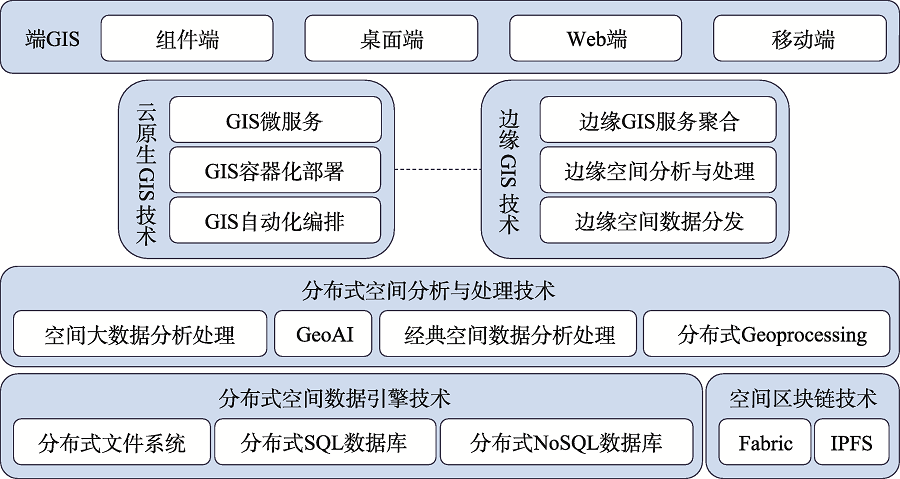
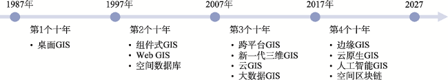
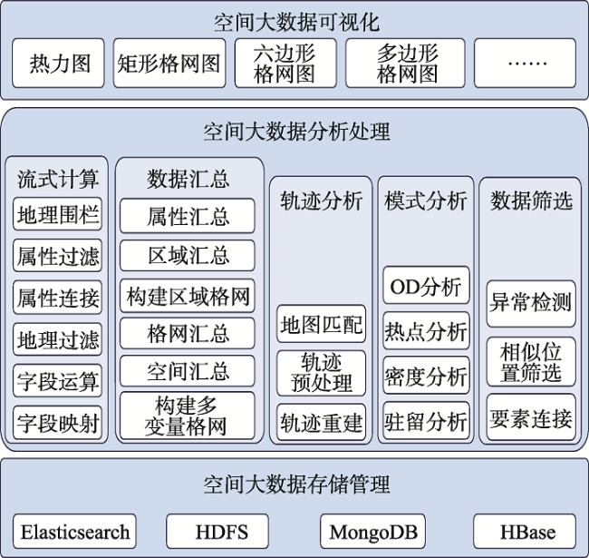
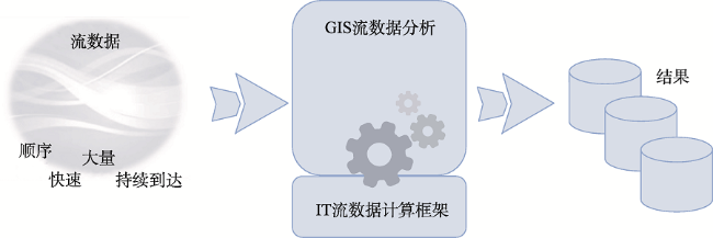
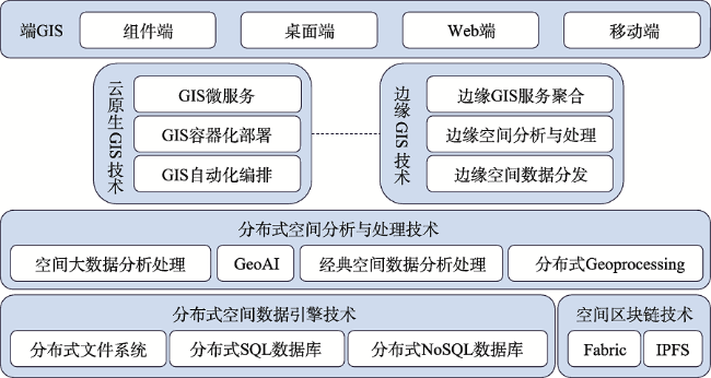
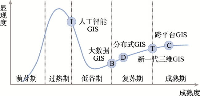
As an important part of the IT system, every advancement of GIS technology is closely related to the rise of the latest IT technology. With the development and application of cloud computing, big data, artificial intelligence and other technologies, nowadays GIS basic software has formed five major technology systems. The big data GIS technology increases the storage management, analysis, processing and visualization of spatial big data, enriching the connotation of spatial data. Artificial intelligence GIS technology enables GIS to enhance the analysis and prediction capabilities of GIS models by combining AI related algorithms. At the same time, the two empower each other. While enhancing GIS capabilities, AI also has spatial analysis and visualization capabilities and expands Its scope of application. The new 3D GIS technology realizes the integration of 2D and 3D GIS and the integration of multi-source heterogeneous data. It promotes 3D GIS from outdoor to indoor, from the macro to the micro. Distributed GIS technology breaks through the limitations of data types and resource capacity. The performance of GIS software is improved by orders of magnitude. It makes highly available and highly reliable GIS applications possible. Cross-platform GIS technology enables GIS software to run on different types of CPU structures and operating systems, meeting the increasingly diverse needs of multi-terminal applications. The five technologies complement each other, and they further expand the capabilities and application scenarios of GIS basic software. Taking SuperMap GIS as an example, this article introduces the specific content of the five GIS technology systems in detail and explains the difficulties and innovations of each technology. Finally, this article uses the hype cycle to divide the development stages of the five major technology systems and discusses the future development trend of GIS technology.
Key words: Big Data GIS; AI GIS; New 3D GIS; Distributed GIS; Cross-platform GIS
SONG Guanfu , CHEN Yong , LUO Qiang , WU Mengyao . Development and Prospect of GIS Platform Software Technology System[J]. Journal of Geo-information Science, 2021 , 23(1) : 2 -15 . DOI: 10.12082/dqxxkx.2021.210015
表1 单机分析与分布式分析效率对比Tab. 1 Efficiency comparison between stand-alone analysis and distributed analysis |
| 功能 | 数据量 | 单机 | 分布式 | 效率提升 |
|---|---|---|---|---|
| 叠加分析(矢量) | 2261万条土地利用 3502 km2的不规则面 | 42.5 min | 2.1 min | 20倍 |
| 区域汇总(矢量) | 4389万条土地利用 省行政区划面 | 14.5 h | 22 min | 40倍 |
| 地形适宜性分析(栅格) | 全球30 m地形数据 | 52 h | 1.1 h | 50倍 |
| 全球耕地面积统计(栅格) | 30 m全球耕地分类栅格数据 全球247个国家/地区面 | 1.5 d | 44 min | 50倍 |
| [1] |
徐冠华 . 创新驱动中国GIS软件发展的必由之路[J]. 地理信息世界, 2017,24(5):1-7.
[
|
| [2] |
宋关福, 李绍俊 . 三十年中国GIS基础软件市场回顾与发展展望[J]. 地理信息世界, 2018,25(1):8-11.
[
|
| [3] |
宋关福, 钟耳顺 . 组件式地理信息系统研究与开发[J]. 中国图象图形学报, 1998,3(4):313-317.
[
|
| [4] |
宋关福, 钟耳顺, 王尔琪 . WebGIS—基于Internet的地理信息系统[J]. 中国图象图形学报, 1998,3:83-86.
[
|
| [5] |
朱江, 宋关福, 钟耳顺 , 等. 基于Web Services和.NET技术的新一代Web GIS研究与开发[J]. 地理信息世界, 2004,2(2):17-20.
[
|
| [6] |
宋关福 . 从光环曲线看GIS基础软件技术发展趋势[EB/OL]. 超图通讯, 2012-31. https://www.supermap.com/magazine/magazine20120231.html.
[
|
| [7] |
周成虎 . 全空间地理信息系统展望[J]. 地理科学进展, 2015,34(2):129-131.
[
|
| [8] |
李清泉, 李德仁 . 大数据GIS[J]. 武汉大学学报·信息科学版, 2014,39(6):641-644,666.
[
|
| [9] |
宋关福 . 当前GIS软件四大关键技术方向[EB/OL]. https://mp.weixin.qq.com/s/tpzE4-FhnxxrrdF-w0lVEA, 2017-07-13.
[
|
| [10] |
李德仁 . 脑认知与空间认知—论空间大数据与人工智能的集成[J]. 武汉大学学报·信息科学版, 2018,43(12):1761-1767.
[
|
| [11] |
宋关福, 卢浩, 王晨亮 , 等. 人工智能GIS软件技术体系初探[J]. 地球信息科学学报, 2020,22(1):76-87.
[
|
| [12] |
孙韵秋 . 基于区块链技术的去中心化管理系统的研究与应用[D]. 南京:南京师范大学, 2019.
[
|
| [13] |
宋关福, 钟耳顺, 吴志峰 , 等. 新一代GIS基础软件的四大关键技术[J]. 测绘地理信息, 2019,44(1):5-12.
[
|
| [14] |
|
| [15] |
|
| [16] |
钟耳顺, 宋关福, 汤国安 , 等. 大数据地理信息系统:原理、技术与应用[M]. 北京: 清华大学出版社, 2020.
[
|
| [17] |
陆锋, 张恒才 . 大数据与广义GIS[J]. 武汉大学学报·信息科学版, 2014,39(6):645-654.
[
|
| [18] |
张晓祥 . 大数据时代的空间分析[J]. 武汉大学学报·信息科学版, 2014,39(6):655-659.
[
|
| [19] |
|
| [20] |
|
| [21] |
|
| [22] |
|
| [23] |
|
| [24] |
|
| [25] |
|
| [26] |
|
| [27] |
宋关福 . 十年打造SuperMap三大技术体系[J]. 地理信息世界, 2011,9(2):83-85.
[
|
| [28] |
宋关福, 钟耳顺, 周芹 , 等. 通用三维GIS场数据模型研究与实践[J]. 测绘地理信息, 2020,45(2):1-7.
[
|
| [29] |
全国地理信息标准化技术委员会. GB/T 30320-2013, 地理空间数据库访问接口[S]. 北京: 中国标准出版社, 2014.
[ Nation-wide Technical Standardization Committee of Geographic Information. GB/T 30320-2013, Geospatial database call-level interface[S]. Beijing: China Standard Press, 2014. ]
|
| [30] |
中国地理信息产业协会. T/CAGIS 1-2019,空间三维模型数据格式[S].北京:中国标准出版社, 2019.
[ China Association for Geospatial Information Society. T/CAGIS 1-2019, Data format for spatial 3D model[S]. Beijing: China Standard Press, 2019. ]
|
| [31] |
中国地理信息产业协会. T/CAGIS 2-2020,空间三维模型数据服务接口[S]. 北京:中国标准出版社, 2020.
[ China Association for Geospatial Information Society. T/CAGIS 2-2020, Service API for spatial 3D model data[S]. Beijing: China Standard Press, 2020. ]
|
| [32] |
张立立, 周芹, 冯振华 . S3M空间三维模型数据格式的特点和应用[J]. 北京测绘, 2020,34(1):23-26.
[
|
| [33] |
|
| [34] |
|
| [35] |
唐浩, 姜春宇, 田稼丰 . 分布式数据库技术及发展趋势研究[J]. 信息通信技术与政策, 2020(11):86-90.
[
|
| [36] |
巴比特.区块链是什么[EB/OL]. http://www.8btc.com/what-is-blockchain, 2020.
[ 8btc. What is blockchain[EB/OL]. http://www.8btc.com/what-is-blockchain, 2020.]
|
| [37] |
CNCF. CNCF cloud native definition v1.0[EB/OL]. https://github.com/cncf/toc/blob/master/DEFINITION.md, 2018-06-11.
|
| [38] |
郭嵩 . 边缘计算与CDN协同技术研究[C]. 2019全国边缘计算学术研讨会, 2019.
[
|
| [39] |
康双勇 . 边缘计算与云计算[J]. 保密科学技术, 2019,000(3):69-69.
[
|
| [40] |
蔡文文, 王少华, 钟耳顺 , 等. 跨平台开源桌面GIS软件的设计与实现[J]. 测绘通报, 2017(1):122-125.
[
|
/
| 〈 |
|
〉 |

