
Journal of Geo-information Science >
Analysis of Spatial Heterogeneity for Soil Attributes and Spectral Indices-based Diagnosis of Coastal Saline-Alkaline Farmland Stress Using UAV Remote Sensing
Received date: 2020-03-26
Request revised date: 2020-06-11
Online published: 2021-05-25
Supported by
Strategic Priority Research Program of the Chinese Academy of Sciences(XDA23050102)
Key Projects of the Chinese Academy of Sciences(KFZD-SW-113)
National Key Research and Development Program of China(2017YFC0503805)
Copyright
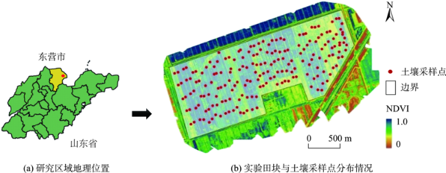
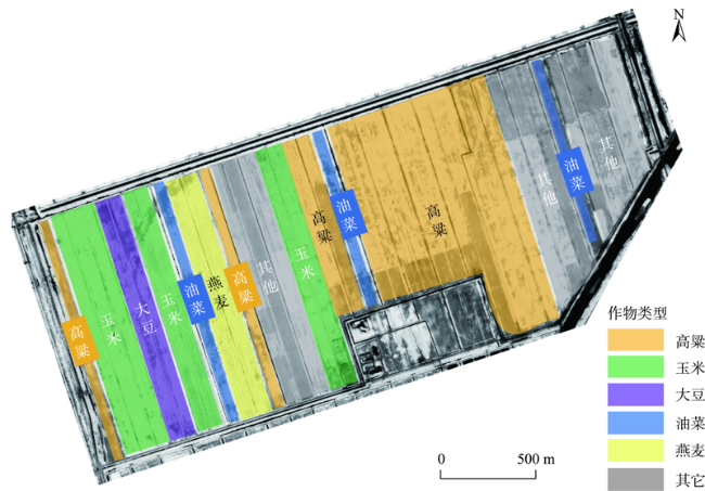
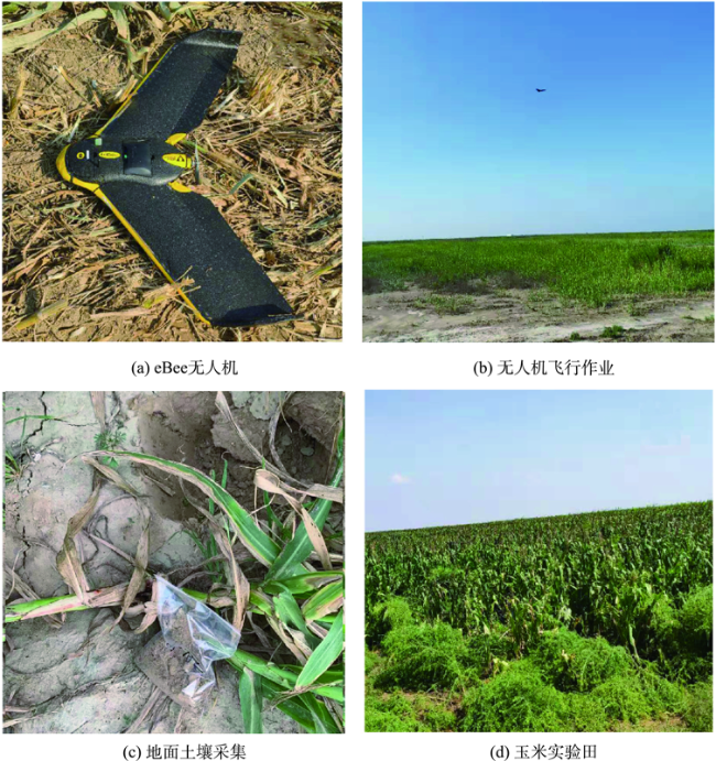
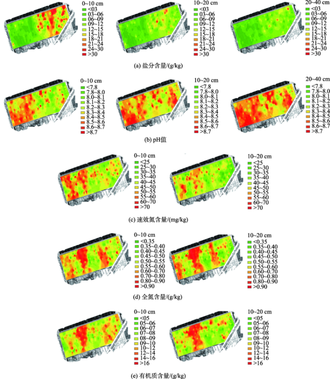
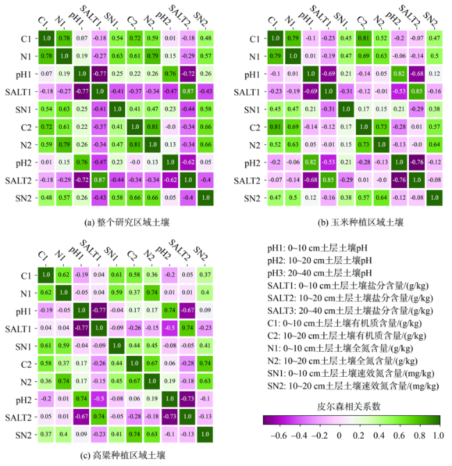
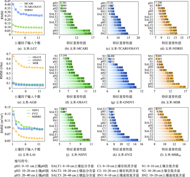
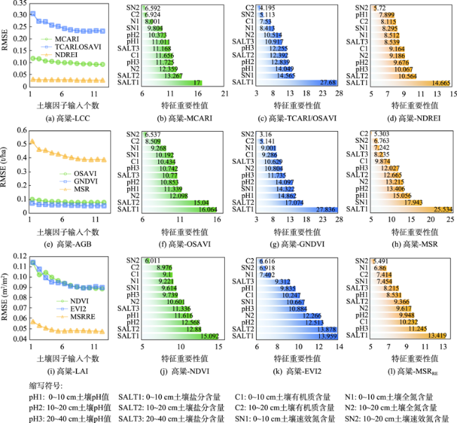
Analysis of the spatial heterogeneity of soil attributes and diagnosis of the soil stress for crops cultivated at large-scale saline-alkali farmland based on remote sensing spectral indices are important to improve the land utilization efficiency and contribute to improve economic and ecological benefits. In this study, we conducted an Unmanned Aerial Vehicle (UAV) remote sensing observation and field measurement over a typical coastal saline-alkali farmland (400 hm2) in the Yellow River Delta of Dongying City, Shandong province in China during the growing season of maize and sorghum in 2019. An eBee wing-fixed UAV platform (SenseFly, Cheseaux-Lausanne, Switzerland) equipped with a multiSPEC-4C multispectral camera (SenseFly, Cheseaux-Lausanne, Switzerland) was used to capture the spectral information of crops. Nine Vegetation Indices (VIs) were selected to characterize the growth status of crops. Among the nine VIs, MCARI, TCARI/OSAVI, and NDREI were sensitive to Leaf Chlorophyll Content (LCC); OSVAI, GNDVI, and MSR were sensitive to Above-Ground Biomass (AGB); and NDVI, EVI2, and MSRRE were sensitive to Leaf Area Index (LAI). Soil sampling (n = 195) at three layers (0~10 cm, 10~20 cm, and 20~40 cm) were implemented evenly across the study area. In total, five soil attributes were measured, including soil salinity (SALT, g/kg), pH, organic matter content (C, g/kg), total nitrogen content (N, g/kg), and available nitrogen content (SN, mg/kg). In our study, we first conducted an interpolation method using Inverse Distance Weighted (IDW) to map the spatial heterogeneity of soil attributes. Our interpolation results show that all the soil attributes showed obvious horizontal spatial heterogeneity, while pH and SALT showed remarkable vertical spatial heterogeneity. Second, we conducted the Pearson Correlation Analysis (PCA) between different soil attributes at each soil layer. The results of PCA showed that SALT and pH had a significantly negative correlation, and these two attributes were not related to SN, N, and C. While SN, N, and C had significantly positive relationships with each other. Finally, the influences of soil attributes on the growth status of maize and sorghum were assessed separately using the Recursive Feature Elimination (RFE) method along with the random forest model based on 3-fold cross validation and 100 times iteration. According to the importance values of soil attributes to VIs, the influence of soil attributes on crop growth from high to low was that SN>N, C>pH>SALT for maize, and SALT>pH>SN, N, C for sorghum. However, the dominant soil attributes that influenced crop growth were SN2 (i.e., SN at 10~20 cm soil layer) and SALT at 0~40 cm soil layer for maize and sorghum, respectively. This study proposes a 'soil-crop growth-VIs' framework for monitoring crop growth status based combining field sampling and UAV remote sensing observations, which is essential for agronomic management in saline-alkali land and contributes to the development of precision agriculture.

Key words: UAV remote sensing; multispectral; vegetation index; soil; crop; saline-alkaline land; precision agriculture; maize; sorghum
ZHU Wanxue , SUN Zhigang , LI Binbin , YANG Ting , LIU Zhen , PENG Jinbang , ZHU Kangying , LI Shiji , LOU Jinyong , HOU Ruixing , LI Jing , YU Wujiang , WANG Yongli , ZHANG Feng , LIU Xiangye , HU Hualang , OUYANG Zhu . Analysis of Spatial Heterogeneity for Soil Attributes and Spectral Indices-based Diagnosis of Coastal Saline-Alkaline Farmland Stress Using UAV Remote Sensing[J]. Journal of Geo-information Science, 2021 , 23(3) : 536 -549 . DOI: 10.12082/dqxxkx.2021.200144
表1 研究选用的光谱指数及计算方法Tab. 1 Vegetation indices used in this study |
| 作物参数 | 光谱指数及公式 | 公式编号 | 参考文献 |
|---|---|---|---|
| LCC | (1) | [24] | |
| (2) | [25] | ||
| (3) | [26] | ||
| AGB | (4) | [22] | |
| (5) | |||
| (6) | |||
| LAI | (7) | [23] | |
| (8) | |||
| (9) |
注:R为红波段反射率;G为绿波段反射率;E为红边波段反射率;NIR为近红外波段反射率;x为调整系数,通常取值为0.16。 |
| [1] |
马玉蕾, 王德, 刘俊民, 等. 黄河三角洲典型植被与地下水埋深和土壤盐分的关系[J]. 应用生态学报, 2013,24(9):2423-2430.
[
|
| [2] |
|
| [3] |
|
| [4] |
|
| [5] |
|
| [6] |
|
| [7] |
|
| [8] |
|
| [9] |
|
| [10] |
|
| [11] |
|
| [12] |
|
| [13] |
|
| [14] |
|
| [15] |
|
| [16] |
|
| [17] |
|
| [18] |
|
| [19] |
|
| [20] |
|
| [21] |
鲍士旦等. 土壤农化分析[M]. 北京: 中国农业出版社, 2000.
[
|
| [22] |
|
| [23] |
|
| [24] |
|
| [25] |
|
| [26] |
|
| [27] |
郭勃. 基于RS和GIS的黄河三角洲盐碱地分级与治理研究[D]. 济南:山东师范大学, 2015.
[
|
| [28] |
|
| [29] |
余笑眉, 吕晓男, 王美琴, 等. 南方丘陵耕地土壤有机质空间插值精度比较——以衢江区为例[J]. 浙江农业学报, 2010,22(5):639-643.
[
|
| [30] |
周四维. 土壤属性三维建模方法及不确定性分析[D]. 武汉:华中农业大学, 2018.
[
|
| [31] |
|
| [32] |
|
| [33] |
赵英时等. 遥感应用分析原理与方法[M]. 北京: 科学出版社, 2003.
[
|
| [34] |
|
| [35] |
|
/
| 〈 |
|
〉 |
