
Journal of Geo-information Science >
Application of Water Extraction Methods from Landsat Imagery for Different Environmental Background
Received date: 2020-06-16
Request revised date: 2020-10-01
Online published: 2021-06-25
Supported by
Capacity Building for Sci-Tech Innovation-Fundamental Scientific Research Funds(20530290059)
Copyright
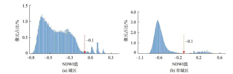
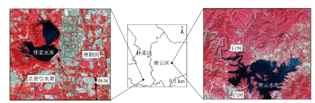
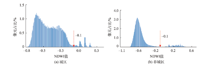
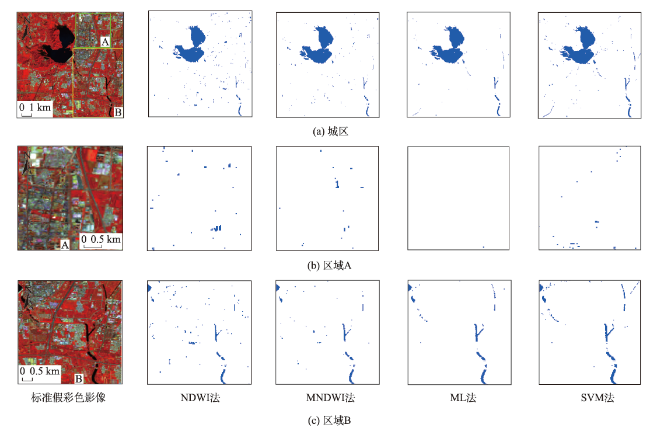
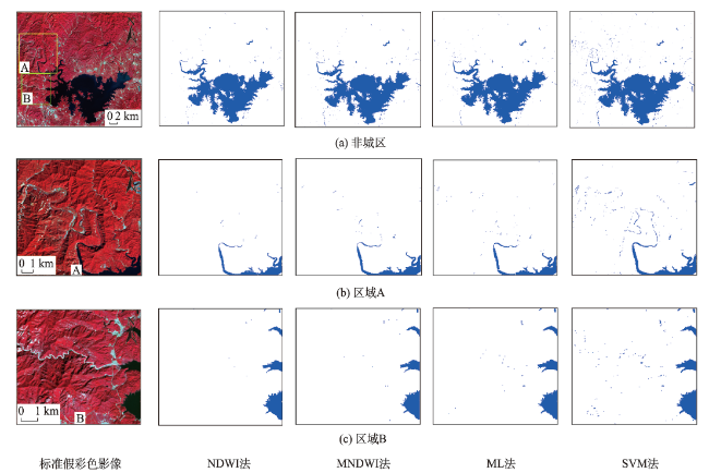
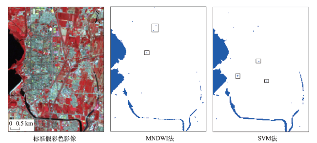
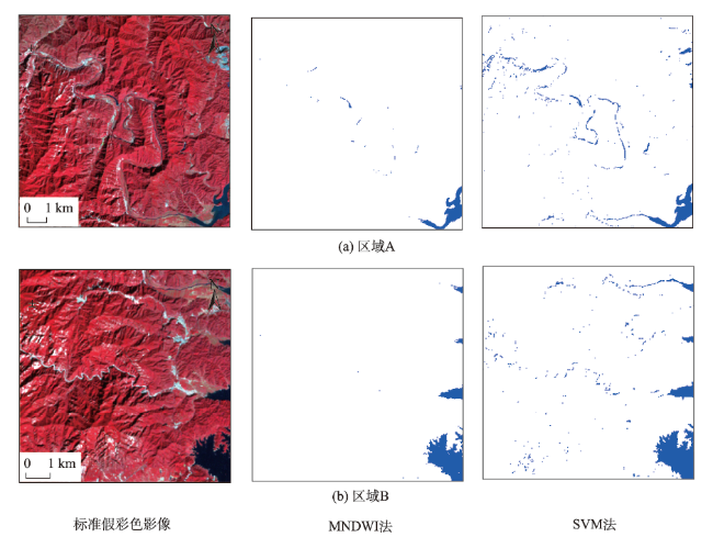
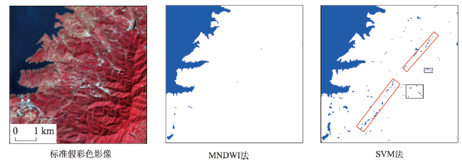
Rapid and accurate extraction of water information from satellite images has been a hot issue in remote sensing applications and has important application value in water resources management, water environment monitoring, and disaster emergency management. Although there are a variety of water extraction methods for Landsat series images, the same method can generate different extraction results in different environmental backgrounds due to the influence of environmental background factors such as geographic location, topography, and water body shape. In order to study the applicability of water extraction methods under different environmental conditions, this article focuses on two typical environments: urban areas around Huairou County, Beijing with severe human influence and strong contrast between light and dark images, and non-urban areas around Beijing Miyun Reservoir with obvious topography and small water bodies. Water index method and classification method are tested based on water extraction and accuracy verification using Landsat 5 (2009) and Landsat 8 (2019) satellite images which have slightly different band settings. The water index method includes Normalized Difference Water Index (NDWI) and Modified Normalized Difference Water Index (MNDWI), while the classification method includes Support Vector Machine (SVM) and Maximum Likelihood (ML). Our results show that SVM has the highest accuracy with overall accuracy > 97% in the urban areas. By selecting training samples reasonably and delicately, the extracted spatial pattern of water results is close to the real water distribution. It applies well to multiple-scale and complex water bodies. In the non-urban areas, SVM can completely identify the fine rivers which are usually difficult to be identified by other methods. It is also suitable for judging the shape and flow direction of small rivers between mountains, though the shadow of the mountain could be easily mixed together by mistake. Due to the difference in sensor band settings, SVM has a better performance in Landsat 8 data. MNDWI can effectively reduce the error extraction rate, resulting in an overall accuracy > 95%. It is convenient to determine the threshold value of MNDWI through visual interpretation, which is more suitable for the rapid extraction of water in the non-urban areas. The environmental background may show different effects on water body extraction. The water index method and classification method have different advantages in different environmental backgrounds. The most suitable method should vary according to the actual situation. In scenarios with higher requirements for efficiency, we should focus on the use of index method, and design a new index which can make full use of the band information. In application scenarios where higher extraction accuracy is required, classification methods can improve the accuracy of water extraction. Moreover, we cannot ignore the differences between interpretation methods in data sources from different sensors. This study provides a reference for the selection of water extraction methods under different environmental backgrounds.
QIAO Danyu , ZHENG Jinhui , LU Han , DENG Lei . Application of Water Extraction Methods from Landsat Imagery for Different Environmental Background[J]. Journal of Geo-information Science, 2021 , 23(4) : 710 -722 . DOI: 10.12082/dqxxkx.2021.200312
表1 Landsat 5、Landsat 8传感器主要参数(多光谱)Tab. 1 Main parameters of Landsat 5 and Landsat 8 (multispectral) |
| Landsat 5 TM | Lansat8 OLI | 地面分辨率/m | ||
|---|---|---|---|---|
| 波段 | 波长范围/μm | 波段 | 波长范围/μm | |
| B1-Blue | 0.45~0.52 | B1-Costal aerosol | 0.43~0.45 | 30 |
| B2-Green | 0.52~0.60 | B2-Blue | 0.45~0.51 | 30 |
| B3-Red | 0.63~0.69 | B3-Green | 0.53~0.59 | 30 |
| B4-NIR | 0.76~0.90 | B4-Red | 0.64~0.67 | 30 |
| B5-SWIR | 1.55~1.75 | B5-NIR | 0.85~0.88 | 30 |
| B6-LWIR | 10.40~12.5 | B6-SWIR1 | 1.57~1.65 | 120/30 |
| B7-SWIR | 2.08~2.35 | B7-SWIR2 | 2.11~2.29 | 30 |
表2 Landsat 8城区与非城区水体提取精度验证表Tab 2 Accuracy verification of water extraction between urban and non-urban areas in Landsat 8 |
| 方法 | OA/% | 错提率/% | 漏提率/% | Kappa系数 | |||||||
|---|---|---|---|---|---|---|---|---|---|---|---|
| 城区 | 非城区 | 城区 | 非城区 | 城区 | 非城区 | 城区 | 非城区 | ||||
| NDWI | 76.77 | 90.05 | 38.62 | 1.34 | 32.56 | 18.67 | 0.4724 | 0.8012 | |||
| MNDWI | 88.35 | 95.06 | 17.58 | 1.37 | 20.93 | 8.54 | 0.7237 | 0.9013 | |||
| ML | 94.09 | 94.82 | 1.40 | 0.87 | 18.02 | 9.49 | 0.8545 | 0.8966 | |||
| SVM | 97.49 | 96.82 | 6.11 | 4.88 | 1.74 | 1.27 | 0.9419 | 0.9363 | |||
表3 Landsat 5城区与非城区水体提取精度验证表Tab. 3 Accuracy verification of water extraction between urban and non-urban areas in Landsat 5 |
| 方法 | OA/% | 错提率/% | 漏提率/% | Kappa系数 | |||||||
|---|---|---|---|---|---|---|---|---|---|---|---|
| 城区 | 非城区 | 城区 | 非城区 | 城区 | 非城区 | 城区 | 非城区 | ||||
| NDWI | 75.81 | 90.04 | 38.92 | 4.80 | 40.70 | 15.19 | 0.4281 | 0.8012 | |||
| MNDWI | 89.61 | 95.06 | 10.42 | 0.17 | 25.00 | 9.49 | 0.7447 | 0.9014 | |||
| ML | 96.77 | 94.57 | 1.88 | 2.68 | 8.72 | 8.07 | 0.9229 | 0.8916 | |||
| SVM | 98.21 | 95.79 | 5.49 | 7.60 | 0.00 | 0.00 | 0.9586 | 0.9156 | |||
| [1] |
|
| [2] |
|
| [3] |
刘桂林, 张落成, 刘剑, 等. 基于Landsat TM影像的水体信息提取[J]. 中国科学院大学学报, 2013,30(5):644-650.
[
|
| [4] |
|
| [5] |
|
| [6] |
徐涵秋. 利用改进的归一化差异水体指数(MNDWI)提取水体信息的研究[J]. 遥感学报, 2005,9(5):589-595.
[
|
| [7] |
段秋亚, 孟令奎, 樊志伟, 等. GF-1卫星影像水体信息提取方法的适用性研究[J]. 国土资源遥感, 2015,27(4):79-84.
[
|
| [8] |
龚文峰, 王鹏, 王双宇, 等. 基于GF-2卫星遥感影像的界河水体信息提取方法[J]. 黑龙江大学工程学报, 2018,9(4):1-7.
[
|
| [9] |
曹萌萌, 毛克彪, 严毅博, 等. 基于MODIS数据的洞庭湖水体和水华时空变化研究[J]. 中国环境科学, 2019,39(6):2523-2531.
[
|
| [10] |
王航, 秦奋. 遥感影像水体提取研究综述[J]. 测绘科学, 2018,43(5):23-32.
[
|
| [11] |
|
| [12] |
|
| [13] |
段号然. 山东微山湖湖面面积时空变化及影响因素[D]. 太原:山西农业大学, 2019.
[
|
| [14] |
王瑾杰, 丁建丽, 张成, 等. 基于GF-1卫星影像的改进SWI水体提取方法[J]. 国土资源遥感, 2017,29(1):29-35.
[
|
| [15] |
郑逢斌, 李坡涛, 韩林果. 基于高分二号影像的城区水体提取方法研究[J]. 河南大学学报(自然科学版), 2020,50(2):213-220.
[
|
| [16] |
陈前, 郑利娟, 李小娟, 等. 基于深度学习的高分遥感影像水体提取模型研究[J]. 地理与地理信息科学, 2019,35(4):43-49.
[
|
| [17] |
|
| [18] |
洪亮, 黄雅君, 杨昆, 等. 复杂环境下高分二号遥感影像的城市地表水体提取[J]. 遥感学报, 2019,23(5):871-882.
[
|
| [19] |
聂欣然, 刘荣, 余健, 等. 基于不同地形的TM影像水体提取方法比较和分析[J]. 江西科学, 2017,35(3):360-366.
[
|
| [20] |
毕海芸, 王思远, 曾江源, 等. 基于TM影像的几种常用水体提取方法的比较和分析[J]. 遥感信息, 2012,27(5):77-82.
[
|
| [21] |
|
| [22] |
|
| [23] |
许静, 陈兴伟, 陈文惠. 基于波谱特征的水体信息提取方法研究[C]. 福建省第十二届水利水电青年学术交流会, 中国福建福州, 2008:20-27.
[
|
| [24] |
陈正超, 张兵, 张浩, 等. 北京一号小卫星绝对辐射定标[C]// 第八届光谱技术与应用研讨会暨交叉学科论坛, 2010: 8-13.
[
|
| [25] |
韩杰, 刘小玉, 李慧娜, 等. 基于6S和FLAASH的Landsat8卫星影像大气校正精度对比研究[J]. 许昌学院学报, 2019,38(5):49-53.
[
|
| [26] |
[
|
| [27] |
王增林, 朱大明. 基于遥感影像的最大似然分类算法的探讨[J]. 河南科学, 2010,28(11):1458-1461.
[
|
| [28] |
|
| [29] |
|
| [30] |
黄奇瑞. 基于粗糙集理论和SVM分类算法的遥感影像分类[D]. 昆明:昆明理工大学, 2012.
[
|
| [31] |
|
| [32] |
樊彦丽. 基于多特征的SVM高分辨率遥感影像分类研究[D]. 北京:中国地质大学(北京), 2018.
[
|
| [33] |
彭中, 阿如旱, 范田芳. 基于决策树分类算法的遥感影像土地利用分类[J]. 阴山学刊(自然科学版), 2018,32(2):99-103.
[
|
| [34] |
王大钊, 王思梦, 黄昌. Sentinel-2和Landsat8影像的四种常用水体指数地表水体提取对比[J]. 国土资源遥感, 2019,31(3):157-165.
[
|
| [35] |
许文宁, 王鹏新, 韩萍, 等. Kappa系数在干旱预测模型精度评价中的应用——以关中平原的干旱预测为例[J]. 自然灾害学报, 2011,20(6):81-86.
[
|
| [36] |
孙琳, 宋爱红, 高文秀. 基于最大似然法和SVM法的太湖流域HJ-1B影像分类[J]. 测绘地理信息, 2012,37(3):30-33.
[
|
| [37] |
王展青, 王传廷, 张富铭, 等. 基于有效候选集的支持向量机样本选择方法[J]. 计算机工程与应用, 2008,44(23):214-216.
[
|
| [38] |
潘洪涛, 王轩, 王晓飞. 训练样本对农作物遥感分类的精度影响研究[J]. 红外与激光工程, 2017,46(S1):149-156.
[
|
| [39] |
吴振彪, 沈德才, 黄练忠, 等. 训练样本数量对最大似然监督分类精度影响的研究[J]. 林业勘查设计, 2018(2):115-117.
[
|
/
| 〈 |
|
〉 |

