
Journal of Geo-information Science >
Delineating China's Urban Traffic Layout by Integrating Complex Graph Theory and Road Network Data
Received date: 2020-07-01
Request revised date: 2020-10-26
Online published: 2021-07-25
Supported by
National Key Research and Development Program of China(2019YFB2102903)
National Natural Science Foundation of China(41801306)
National Natural Science Foundation of China(41671408)
National Natural Science Foundation of China(41901332)
Open Fund of State Laboratory of Information Engineering in Surveying, Mapping and Remote Sensing, Wuhan University(18S01)
Natural Science Fund of Hubei Province(2017CFA041)
Copyright
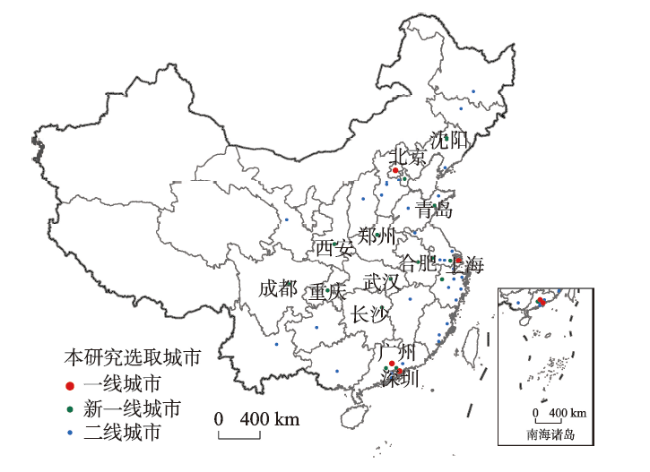
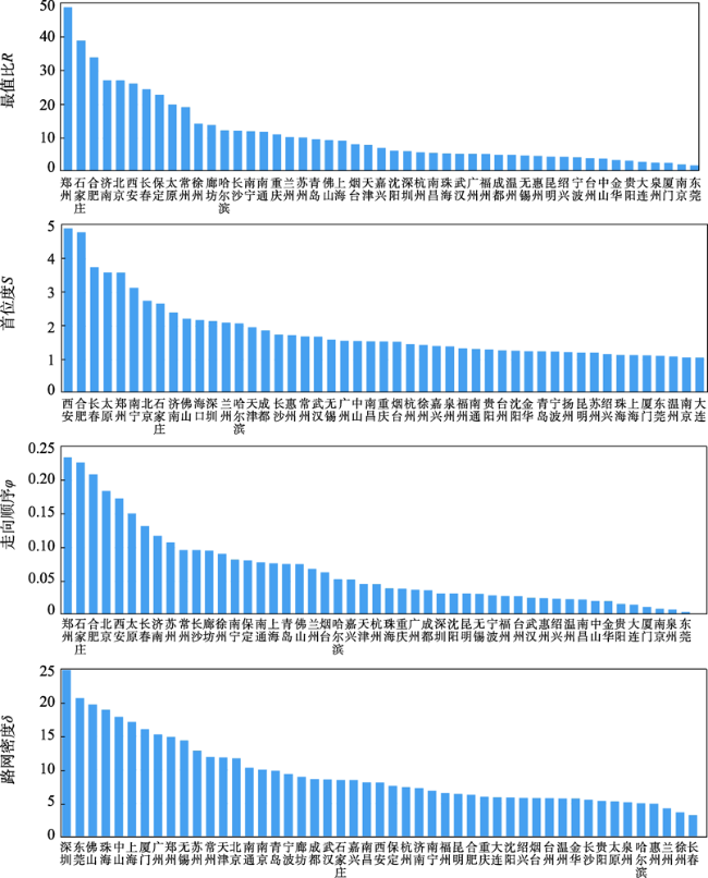
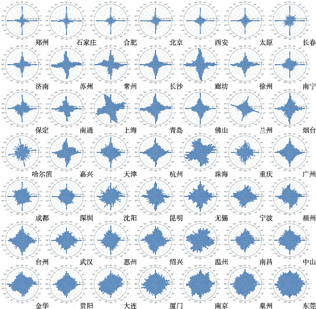
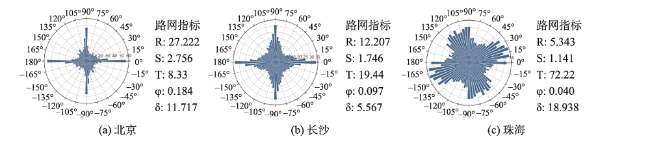
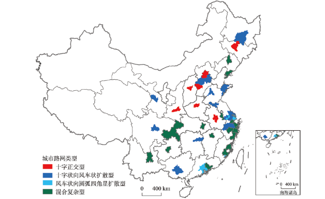
The rapid development of urbanization has promoted China's urban road network's continuous expansion and growth. The urban road network is a dynamic, open, and self-organized spatial complex network, which constitutes a city's structural framework. The study on urban road networks' structural characteristics can provide a significant application value for road network planning and urban construction. In the related studies of the structural characteristics of urban road networks, few scholars have paid attention to the whole urban road network structure from the perspective of road alignment in China. Besides, recent studies lack an overall evaluation on the road network of major cities in China. In this paper, 49 cities, including the first- and second-tier and first-tier new cities in China, are selected as study areas and the urban road network data in February 2020 are taken as experimental data. Firstly, we use the graph theory and rose diagrams to visualize the road network's directional characteristics in 49 cities. The complex structure of the urban road network is qualitatively analyzed. Then, we select five road network indicators including the maximum ratio R, the road primacy degree S, the ratio over threshold T, the orientation-order φ, and the road network density δ. Based on the five indicators, cluster analysis is carried out for the road networks of 49 cities in this paper. And the characteristics of the spatial distribution of urban road network in China are explored. The results show that the north-south and east-west roads are the main alignment of urban roads in China. Because of the influence of terrain, some cities plan routes along the direction, which is favorable to traffic and resident's living. Based on the clustering of road network indicators, four types of the urban road network are obtained, including cross orthogonal type, cross to windmill type, windmill to arc type, and mixed complex type. There are significant differences among four types of the urban road network in directional characteristics highlighted in complexity and order. In view of the spatial distribution of road network types, road networks of cross orthogonal type and cross to windmill type are mainly distributed in China's inland areas. In contrast, road networks of the windmill to arc type and mixed complex type are mainly distributed in coastal areas. This paper explores the current traffic layout in major cities in China by analyzing the characteristics of road network's distribution in the first- and second-tier and first-tier new cities in China. This study can provide a reference for road planning and optimization of road network layout in new urban districts.
KOU Shihao , YAO Yao , ZHENG Hong , ZHOU Jianfeng , ZHANG Jiaqi , REN Shuliang , WANG Ruifan , GUAN Qingfeng . Delineating China's Urban Traffic Layout by Integrating Complex Graph Theory and Road Network Data[J]. Journal of Geo-information Science, 2021 , 23(5) : 812 -824 . DOI: 10.12082/dqxxkx.2021.200340
表1 基于路网指标的一、二线及新一线城市的K-means聚类中心结果Tab. 1 Cluster center results of the K-means in in the first and second-tier and first-tier new cities based on road network indicators |
| 类别 | 最值比R | 首位度S | 过阈值比T | 走向顺序φ | 路网密度δ |
|---|---|---|---|---|---|
| 1 | 0.627 | 0.692 | 0.022 | 0.795 | 0.233 |
| 2 | 0.218 | 0.175 | 0.217 | 0.303 | 0.213 |
| 3 | 0.074 | 0.117 | 0.643 | 0.139 | 0.698 |
| 4 | 0.062 | 0.072 | 0.813 | 0.090 | 0.162 |
表2 本研究选取的一、二线及新一线城市的路网指标聚类结果Tab. 2 Clustering results of road network indicators in the first and second-tier and first-tier new cities selected in this study |
| 类别 | 城市 |
|---|---|
| Ⅰ | 郑州、北京、石家庄、西安、合肥、太原、长春 |
| Ⅱ | 苏州、常州、天津、南通、青岛、成都、保定、廊坊、杭州济南、绍兴、长沙、烟台、兰州、徐州、哈尔滨、南宁 |
| Ⅲ | 深圳、东莞、佛山、珠海、上海、中山、厦门、广州、无锡 |
| Ⅳ | 南京、宁波、武汉、嘉兴、南昌、福州、台州、金华、大连沈阳、温州、贵阳、泉州、惠州、昆明、重庆 |
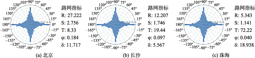
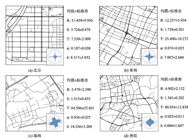
图6 典型城市的部分道路网、玫瑰图及指标均值和标准差Fig. 6 Part of road network, rose diagrams, index mean and standard deviation of typical cities |
| [1] |
李德仁, 李清泉, 杨必胜, 等. 3S技术与智能交通[J]. 武汉大学学报(信息科学版), 2008,3(4):331-336.
[
|
| [2] |
石飞, 王炜. 城市路网结构分析[J]. 城市规划, 2007,31(8):68-73.
[
|
| [3] |
|
| [4] |
郭继孚, 刘莹, 余柳. 对中国大城市交通拥堵问题的认识[J]. 城市交通, 2011,9(2):8-14.
[
|
| [5] |
|
| [6] |
吴凡, 石飞, 肖沛余, 等. 城市路网布局结构对公共交通出行的影响[J]. 南京工业大学学报(自然科学版), 2019,41(4):520-528.
[
|
| [7] |
|
| [8] |
王法辉, 刘瑜, 王姣娥. 交通网络与城市结构研究——理论框架与中美两国实证案例[J]. 地理科学进展, 2014,33(10):1289-1299.
[
|
| [9] |
顾朝, 林甄峰, 张京祥. 集聚与扩散——城市空间结构新论[M]. 南京: 东南大学出版社, 2000.
[
|
| [10] |
周春山, 叶昌东. 中国城市空间结构研究评述[J]. 地理科学进展, 2013,32(7):1030-1038.
[
|
| [11] |
钟业喜, 陆玉麒. 基于铁路网络的中国城市等级体系与分布格局[J]. 地理研究, 2011,30(5):785-794.
[
|
| [12] |
宋琼, 谢志祥, 李同昇, 等. 长江中游城市群城市网络空间结构研究[J]. 地域研究与开发, 2017,36(3):59-65.
[
|
| [13] |
胡国建, 陈传明, 金星星, 等. 中国城市体系网络化研究[J]. 地理学报, 2019,74(4):681-693.
[
|
| [14] |
梁宇, 郑新奇, 白书建. 利用空间句法模型研究京津冀路网的通达性[J]. 测绘通报, 2016(10):101-105.
[
|
| [15] |
李沛权, 曹小曙. 广佛都市圈公路网络通达性及其空间格局[J]. 经济地理, 2011,31(3):371-378.
[
|
| [16] |
沈惊宏, 陆玉麒, 兰小机. 基于分形理论的公路交通网络与区域经济发展关系的研究[J]. 地理科学, 2012,32(6):658-665.
[
|
| [17] |
曾映敏, 张红, 陆权, 等. 多空间尺度道路网结构分形特征分析[J]. 地理信息世界, 2018,25(5):35-40.
[
|
| [18] |
王庆国, 张昆仑. 复杂网络理论的武汉市路网结构特征[J]. 测绘科学, 2019,44(4):66-71.
[
|
| [19] |
|
| [20] |
|
| [21] |
|
| [22] |
|
| [23] |
|
| [24] |
刘波, 时雨, 刘雪朝, 等. 开放式街道地图在城市发展水平分析中的应用[J]. 测绘科学, 2019,44(7):141-146.
[
|
| [25] |
郝怀旭, 万太礼, 罗年学. 利用OpenStreetMap数据进行高空间分辨率遥感影像分类[J]. 测绘通报, 2019,10(7):69-72.
[
|
| [26] |
张宇, 王琦, 吴文周, 等. 点状地名信息的加权泰森多边形检索法[J]. 测绘学报, 2017,46(11):1919-1926.
[
|
| [27] |
田晶, 武晓环, 林镠鹏, 等. 城市道路网的度相关性及其与网络鲁棒性的关系研究[J]. 武汉大学学报·信息科学版, 2016,41(5):672-678.
[
|
| [28] |
赵玲, 邓敏, 王佳, 等. 基于复杂网络理论的城市路网结构特性分析[J]. 地理与地理信息科学, 2010,26(5):11-15.
[
|
| [29] |
黄杉, 武前波, 崔万珍. 国内外城市综合体的发展特征与类型模式[J]. 经济地理, 2013,33(4):1-8.
[
|
| [30] |
张巧英. 基于DMSP/OLS灯光数据的新一线城市空间扩展研究[J]. 测绘地理信息, 2015,40(1):72-75.
[
|
| [31] |
王艳东, 殷寒露, 吴胜, 等. OpenStreetMap路网数据的几何精度评价[J]. 测绘与空间地理信息, 2019,42(2):1-3.
[
|
| [32] |
张正豪, 冯伍法, 王涛, 等. 一种改进的基于暗原色先验信息的航空遥感图像去雾方法[J]. 测绘科学技术学报, 2018,35(2):182-186.
[
|
| [33] |
雷仲敏, 康俊杰. 城市首位度评价:理论框架与实证分析[J]. 城市发展研究, 2010,17(4):33-38.
[
|
| [34] |
刘锐, 胡伟平, 王红亮, 等. 基于核密度估计的广佛都市区路网演变分析[J]. 地理科学, 2011,31(1):81-86.
[
|
| [35] |
周亮, 陆锋, 张恒才. 基于动态中介中心性的城市道路网实时分层方法[J]. 地球信息科学学报, 2012,14(3):292-298.
[
|
| [36] |
|
| [37] |
|
| [38] |
周爱武, 于亚飞. K-Means聚类算法的研究[J]. 计算机技术与发展, 2011,21(2):62-65.
[
|
| [39] |
|
| [40] |
刘承良, 段德忠, 余瑞林, 等. 武汉城市圈城乡道路网结构演化及复杂性研究[J]. 地理科学, 2014,34(4):401-410.
[
|
| [41] |
肖汉光, 蔡从中. 特征向量的归一化比较性研究[J]. 计算机工程与应用, 2009,45(22):117-119.
[
|
| [42] |
王思忠. 浅谈城市路网规划布局设计[J]. 现代城市研究, 2003(S2):10-13.
[
|
| [43] |
|
| [44] |
|
/
| 〈 |
|
〉 |