
Journal of Geo-information Science >
Crop Planting Area Extraction based on Google Earth Engine and NDVI Time Series Difference Index
Received date: 2020-06-08
Request revised date: 2020-08-24
Online published: 2021-07-25
Supported by
National Natural Science Foundation of China(41701422)
Key Research and Development and Promotion Projects in Henan Province(192102310251)
Copyright
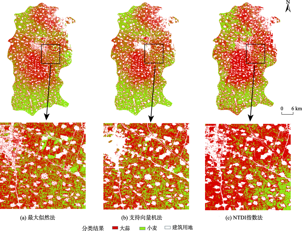
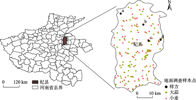
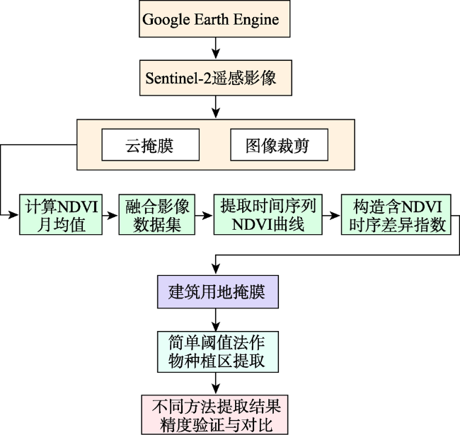
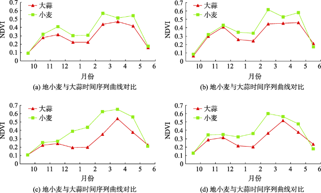
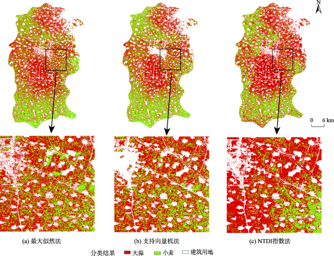
In order to improve the efficiency of remote sensing monitoring of crop planting and expand applications of remote sensing data, a method of crop planting area extraction based on NDVI time series difference index is proposed. With the development of remote sensing and cloud computing technologies, Google Earth Engine, as a global-scale geospatial analysis cloud platform, overcomes the disadvantages of traditional single-machine computing and brings new opportunities for rapid remote sensing classification. In this study, taking Qi County in Henan province as the study area, the NDVI time series difference index of different crops is constructed according to the characteristics of time series NDVI curve of each crop to extract crop planting information and distinguish different crop types using multi-temporal Sentinel-2 images in 2019-2020 based on the Google Earth Engine platform. The extraction accuracy is verified and compared with other existing methods. The results show that the NDVI time series difference index is based on crop phenology information and developed using GEE's high-performance computing capability, which forms a framework for rapid crop planting information extraction and has obvious advantages over traditional local computing. The winter wheat and garlic planting areas in Qi County have obvious spatial variation. The winter wheat planting areas are mainly concentrated in the northwest and southern rural residential areas of the study area. While the garlic in Qi County is mainly concentrated in the central and northeastern part of the study area due to the needs of transportation. Compared with other methods using support vector machine and maximum likelihood, the overall accuracy of crop planting area extraction using the NDVI time series difference index reaches 83.72%, and the Kappa coefficient is 0.67. The overall accuracy and the Kappa coefficient are 10.02% and 0.21 respectively higher than the maximum likelihood method, and are 4.18% and 0.09 respectively higher than the support vector machine method, which indicates that our method can extract crop planting information with high efficiency and high accuracy. We develop an efficient and accurate monitoring method for regional crop planting information extraction and expand the application of remote sensing data in the agricultural field, which has significant value for future agricultural applications.
JIANG Yilan , CHEN Baowang , HUANG Yufang , CUI Jiaqi , GUO Yulong . Crop Planting Area Extraction based on Google Earth Engine and NDVI Time Series Difference Index[J]. Journal of Geo-information Science, 2021 , 23(5) : 938 -947 . DOI: 10.12082/dqxxkx.2021.200291
表1 Sentinel-2数据参数Tab. 1 Sentinel-2 data parameters |
| 属性 | 中心波长/μm | 分辨率/m | |
|---|---|---|---|
| Band 1 | 气溶胶 | 0.443 | 60 |
| Band 2 | 蓝 | 0.490 | 10 |
| Band 3 | 绿 | 0.560 | 10 |
| Band 4 | 红 | 0.665 | 10 |
| Band 5 | 植被红边1 | 0.705 | 20 |
| Band 6 | 植被红边2 | 0.740 | 20 |
| Band 7 | 植被红边3 | 0.783 | 20 |
| Band 8 | 近红外 | 0.842 | 10 |
| Band 8A | 植被红边4 | 0.865 | 20 |
| Band 9 | 水蒸气 | 0.945 | 60 |
| Band 10 | 短波红外-卷云 | 1.375 | 60 |
| Band 11 | 短波红外1 | 1.610 | 20 |
| Band 12 | 短波红外2 | 2.190 | 20 |
| QA60 | 云掩膜 | - | - |
表2 主要作物生育期Tab. 2 Main crop growth period |
| 作物类型 | ||
|---|---|---|
| 小麦 | 大蒜 | |
| 1月 | 越冬 | 幼苗期 |
| 2月 | 越冬 | 幼苗期 |
| 3月 | 返青 | 幼苗期 |
| 4月 | 拔节孕穗 | 花芽和鳞茎分化期 |
| 5月 | 抽穗灌浆 | 鳞茎肥大期 |
| 6月 | 成熟 | 休眠期 |
| 7月 | - | 休眠期 |
| 8月 | - | 休眠期 |
| 9月 | - | |
| 10月 | 播种出苗 | 播种发芽 |
| 11月 | - | 幼苗期 |
| 12月 | 分蘖 | 幼苗期 |
表3 杞县作物种植区提取验证精度对比Tab. 3 Comparison of verification accuracy of crop planting structure in Qi County |
| 分类方法 | 大蒜 | 小麦 | 总体精度/% | Kappa 系数 | ||
|---|---|---|---|---|---|---|
| 用户精度/% | 制图精度/% | 用户精度/% | 制图精度/% | |||
| NTDI指数法 | 88.94 | 82.59 | 77.44 | 85.33 | 83.72 | 0.67 |
| 最大似然法 | 77.78 | 77.40 | 67.94 | 68.43 | 73.71 | 0.46 |
| 支持向量机法 | 91.74 | 61.14 | 75.19 | 95.28 | 79.54 | 0.58 |
| [1] |
白燕英, 高聚林, 张宝林. 基于Landsat8影像时间序列NDVI的作物种植结构提取[J]. 干旱区地理, 2019,42(4):893-901.
[
|
| [2] |
|
| [3] |
贾坤, 李强子, 田亦陈, 等. 微波后向散射数据改进农作物光谱分类精度研究[J]. 光谱学与光谱分析, 2011,31(2):483-487.
[
|
| [4] |
胡琼, 吴文斌, 宋茜, 等. 农作物种植结构遥感提取研究进展[J]. 中国农业科学, 2015,48(10):1900-1914.
[
|
| [5] |
马丽, 徐新刚, 刘良云, 等. 基于多时相NDVI及特征波段的作物分类研究[J]. 遥感技术与应用, 2008,23(5):520-524.
[
|
| [6] |
康峻, 侯学会, 牛铮, 等. 基于拟合物候参数的植被遥感决策树分类[J]. 农业工程学报, 2014,30(9):148-156.
[
|
| [7] |
张焕雪, 曹新, 李强子, 等. 基于多时相环境星NDVI时间序列的农作物分类研究[J]. 遥感技术与应用, 2015,30(2):304-311.
[
|
| [8] |
李晓东, 姜琦刚. 基于多时相遥感数据的农田分类提取[J]. 农业工程学报, 2015,31(7):145-150.
[
|
| [9] |
陈君颖, 田庆久. 高分辨率遥感植被分类研究[J]. 遥感学报, 2007,11(2):221-227.
[
|
| [10] |
Bolton,
|
| [11] |
|
| [12] |
郝鹏宇, 牛铮, 王力, 等. 基于历史时序植被指数库的多源数据作物面积自动提取方法[J]. 农业工程学报, 2012,28(23):123-131,297.
[
|
| [13] |
潘耀忠, 李乐, 张锦水, 等. 基于典型物候特征的MODIS-EVI时间序列数据农作物种植面积提取方法——小区域冬小麦实验研究[J]. 遥感学报, 2011,15(3):578-594.
[
|
| [14] |
陈安旭, 李月臣. 基于Sentinel-2影像的西南山区不同生长期水稻识别[J]. 农业工程学报, 2020,36(7):192-199.
[
|
| [15] |
刘佳, 王利民, 姚保民, 等. 基于多时相OLI数据的宁夏大尺度水稻面积遥感估算[J]. 农业工程学报, 2017,33(15):200-209.
[
|
| [16] |
黄健熙, 贾世灵, 武洪峰, 等. 基于GF-1 WFV影像的作物面积提取方法研究[J]. 农业机械学报, 2015,46(S1):253-259.
[
|
| [17] |
刘佳, 王利民, 杨福刚, 等. 基于HJ时间序列数据的农作物种植面积估算[J]. 农业工程学报, 2015,31(3):199-206.
[
|
| [18] |
周静平, 李存军, 史磊刚, 等. 基于决策树和面向对象的作物分布信息遥感提取[J]. 农业机械学报, 2016,47(9):318-326,333.
[
|
| [19] |
康峻, 侯学会, 牛铮, 等. 基于拟合物候参数的植被遥感决策树分类[J]. 农业工程学报, 2014,30(9):148-156.
[
|
| [20] |
李鑫川, 徐新刚, 王纪华, 等. 基于时间序列环境卫星影像的作物分类识别[J]. 农业工程学报, 2013,29(2):169-176,298.
[
|
| [21] |
张荣群, 王盛安, 高万林, 等. 基于时序植被指数的县域作物遥感分类方法研究[J]. 农业机械学报, 2015,46(S1):246-252.
[
|
| [22] |
杜保佳, 张晶, 王宗明, 等. 应用Sentinel-2A NDVI时间序列和面向对象决策树方法的农作物分类[J]. 地球信息科学学报, 2019,21(5):740-751.
[
|
| [23] |
杨闫君, 占玉林, 田庆久, 等. 基于GF-1/WFVNDVI时间序列数据的作物分类[J]. 农业工程学报, 2015,31(24):155-161.
[
|
| [24] |
张焕雪, 曹新, 李强子, 等. 基于多时相环境星NDVI时间序列的农作物分类研究[J]. 遥感技术与应用, 2015,30(2):304-311.
[
|
| [25] |
刘焕军, 闫岩, 张新乐, 等. 面向农业区划的作物种植结构遥感提取[J]. 中国农业资源与区划, 2017,38(8):43-54.
[
|
| [26] |
王林江, 吴炳方, 张淼, 等. 关键生育期冬小麦和油菜遥感分类方法[J]. 地球信息科学学报, 2019,21(7):1121-1131.
[
|
| [27] |
徐涵秋. 一种快速提取不透水面的新型遥感指数[J]. 武汉大学学报·信息科学版, 2008,33(11):1150-1153,1211.
[
|
| [28] |
赵英时. 遥感应用分析原理与方法[M]. 北京: 科学出版社, 2003.
[
|
| [29] |
王利军, 郭燕, 贺佳, 等. 基于决策树和SVM的Sentinel-2A影像作物提取方法[J]. 农业机械学报, 2018,49(9):146-153.
[
|
| [30] |
Congalton,
|
/
| 〈 |
|
〉 |