
Journal of Geo-information Science >
Application Research of Sentinel-1 SAR in Flood Range Extraction and Polarization Analysis
Received date: 2020-11-28
Request revised date: 2021-03-12
Online published: 2021-08-25
Supported by
National Key Research and Development Program of China(2018YFC0407900)
Copyright
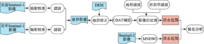
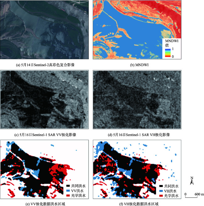
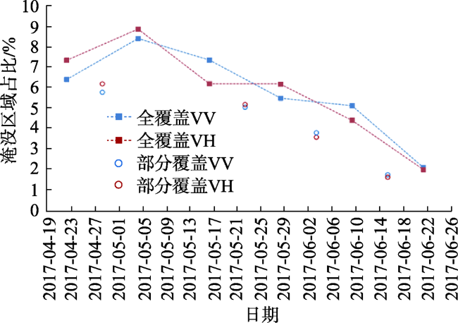
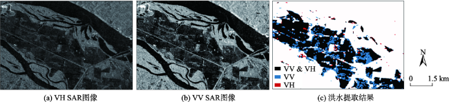
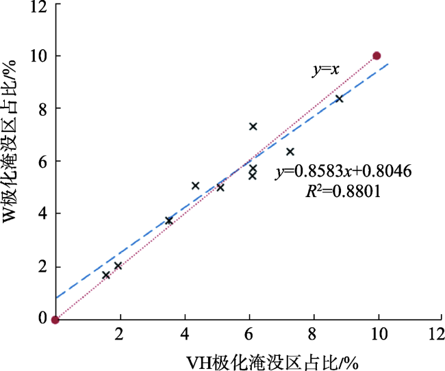
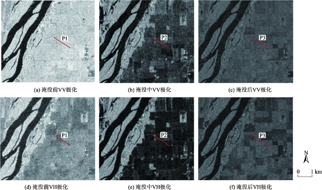
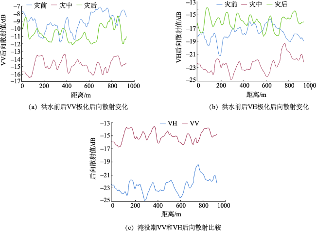
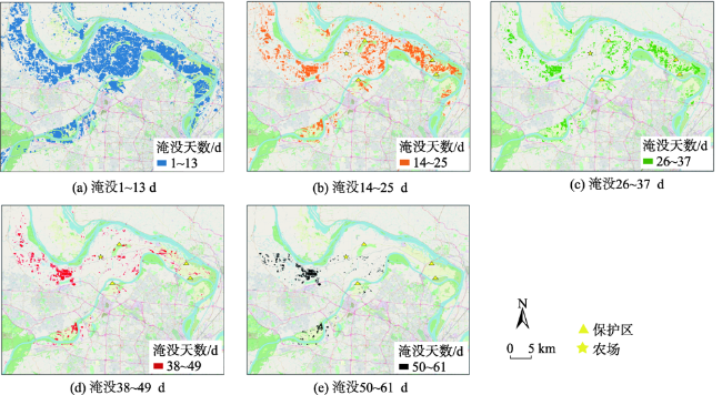
In flood disaster monitoring, fast and accurate detection of inundated area and flooded disaster region is of great value for flood control and post-disaster reconstruction work. This paper takes the 2017 Saint Louis flood in the United States as an example. Based on Sentinel-1 SAR data, the method of combining change detection and threshold was used to achieve large-scale flood inundation extraction. Firstly, the SAR data were pre-processed with sigma radiation calibration and Refined Lee filtering, which were effective in improving the contrast of land and water bodies, as well as attenuating the coherent speckle noise. Secondly, the difference image between the reference image and flooded image was defined by change detection methodology and the image histogram was divided by the quantile threshold method to extract the submerge area. Finally, image post-processing was performed on the thresholded results to reduce misclassification. Areas not close to the water surface and whose slope was higher than 3 degrees were defined as non-flood region for exclusion using the digital elevation model. Then, the small particle noise and holes were removed by morphological filtering to achieve large-scale flood inundation extraction. The boundary information was retained while keeping the original size of the flood category unchanged. Heavy rainfall was the main cause of the 2017 extensive flooding in Saint Louis. The low-lying northern river bend area was the most severely affected, inundated for up to two months while the main city suffered less damage due to its high terrain and timely flood protection. Until now, there have been few studies on the effectiveness of different synthetic aperture radar data polarization modes in relation to flood detection. The Sentinel-1 VV/VH polarization data were compared with the flood inundation extraction range obtained from the Sentinel-2 optical image during the same period. Then, the flood detection applicability of the polarization mode was evaluated based on the comparison results. The scattering response characteristics in the multi-polarization patterns were analyzed by plotting the back-scattering cross-sectional lines for different periods of each polarization. The results show that both Sentinel-1 VV and VH polarization data can identify flood with a high accuracy of over 82%. Compared with VH polarization mode, VV polarization mode has fewer false positives. In the same region, the scattering degree of Sentinel-1 VV polarization signal was 28% smaller than that of VH, showing more sensitive information from the flood. Therefore, Sentinel-1 VV polarization mode is more suitable for monitoring the inundation range of flood disaster.
CHEN Sainan , JIANG Mi . Application Research of Sentinel-1 SAR in Flood Range Extraction and Polarization Analysis[J]. Journal of Geo-information Science, 2021 , 23(6) : 1063 -1070 . DOI: 10.12082/dqxxkx.2021.200717
表1 本研究所采用的Sentinel-1 SAR数据相关信息[12]Tab. 1 Information about the Sentinel-1 SAR data used in this study |
| Sentinel-1 影像 | 获取时间 | 轨道 | 覆盖占比/% |
|---|---|---|---|
| 1 | 2017-04-22 | 92 | 100 |
| 2 | 2017-05-04 | 92 | 100 |
| 3 | 2017-05-16 | 92 | 100 |
| 4 | 2017-05-28 | 92 | 100 |
| 5 | 2017-06-09 | 92 | 100 |
| 6 | 2017-06-21 | 92 | 100 |
| 7 | 2017-04-28 | 165 | 46 |
| 8 | 2017-05-22 | 165 | 46 |
| 9 | 2017-06-03 | 165 | 46 |
| 10 | 2017-06-15 | 165 | 46 |
表2 VV极化洪水监测精度Tab. 2 Flood monitoring accuracy of VV polarization |
| SAR VV/Sentinel-2 | 洪水/km2 | 非洪水/km2 | 用户精度/% |
|---|---|---|---|
| 洪水/km2 | 4.37 | 0.6492 | 86.88 |
| 非洪水/km2 | 1.37 | 6.95 | 83.53 |
| 生产者精度/% | 76.13 | 91.33 |
表3 VH极化洪水监测精度Tab. 3 Flood monitoring accuracy of VH polarization |
| SAR VH/Sentinel-2 | 洪水/km2 | 非洪水/km2 | 用户精度/% |
|---|---|---|---|
| 洪水/km2 | 4.21 | 1.18 | 78.11 |
| 非洪水/km2 | 1.53 | 6.43 | 80.78 |
| 生产者精度/% | 73.34 | 84.49 |
| [1] |
葛鹏, 岳贤平. 洪涝灾害评估研究综述[J]. 南通大学学报(自然科学版), 2012,11(4):68-74.
[
|
| [2] |
|
| [3] |
彭顺风, 李凤生, 黄云. 基于RADARSAT-1影像的洪涝评估方法[J]. 水文, 2008,28(2):34-37.
[
|
| [4] |
|
| [5] |
郑伟, 刘闯, 曹云刚, 等. 基于Asar与TM图像的洪水淹没范围提取[J]. 测绘科学, 2007,32(5):180-181.
[
|
| [6] |
|
| [7] |
|
| [8] |
汤玲英, 刘雯, 杨东, 等. 基于面向对象方法的Sentinel-1A SAR在洪水监测中的应用[J]. 地球信息科学学报, 2018,20(3):377-384.
[
|
| [9] |
吴文会, 王丽欣, 马卓. 基于Sentinel-1B SAR数据的洪水提取和监测[J]. 测绘与空间地理信息, 2019,42(4):110-111.
[
|
| [10] |
|
| [11] |
|
| [12] |
Sentinel卫星数据(2017)[EB/OL]. https://scihub.copernicus.eu/dhus/#/home.
[ Sentinel satellite data (2017)[EB/OL]. https://scihub.copernicus.eu/dhus/#/home. ]
|
| [13] |
|
| [14] |
陈天慧, 田耀. 美国防洪治理的策略演变及启示——以密西西比河洪水治理为例[J]. 中国水利, 2017,13:51-53.
[
|
| [15] |
叶虎平, 李铜基. 水体光谱特性监督分类方法研究[J]. 海洋技术学报, 2009,28(3):101-105.
[
|
| [16] |
|
| [17] |
|
| [18] |
徐涵秋. 利用改进的归一化差异水体指数(MNDWI)提取水体信息的研究[J]. 遥感学报, 2005,9(5):589-595.
[
|
| [19] |
|
/
| 〈 |
|
〉 |