
Journal of Geo-information Science >
Application of Geo-information Science and Technology in Poverty Alleviation in China
Received date: 2020-10-22
Request revised date: 2020-12-08
Online published: 2021-10-25
Supported by
The National Science Fund for Distinguished Young Scholars(41725006)
Copyright
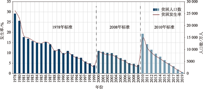
Through various exploration and practice of poverty alleviation, China has embarked on a path of poverty alleviation with Chinese characteristics, which has greatly reduced the number of rural poor people and significantly improved the living standard in poverty-stricken areas. For a long time, the monitoring of socioeconomic and environmental conditions in poverty-stricken areas is based on all kinds of statistical data, reports, paper files, etc., based on administrative units, lacking effective and accurate spatial location information. With the rapid development of geo-information science such as Remote Sensing (RS) and Geographic Information System (GIS), the real-time and efficient capture and calculation ability of spatial information greatly improves the efficiency and decision support level of poverty alleviation. This paper expounds the contributions of geo-information science on China's poverty alleviation from the following aspects:① monitoring and evaluation of natural resources and environment in poverty-stricken areas based on multi-source geospatial data; ② monitoring, early warning, and management of natural disasters in poverty-stricken areas; ③ analysis of poverty causing factors and poverty prediction; ④ decision support system for targeted poverty alleviation based on the mechanism of targeted poverty alleviation. China aims to eradicate absolute poverty in 2020, so the application of geo-information science in poverty alleviation will mainly focus on the establishment of monitoring and assistance mechanism to prevent poverty returning and alleviate the relative poverty. Moreover, under the background of rural revitalization, using geo-information science and technology to promote rural infrastructure information construction will be the focus of the next step.

HU Shan , GE Yong , LIU Mengxiao . Application of Geo-information Science and Technology in Poverty Alleviation in China[J]. Journal of Geo-information Science, 2021 , 23(8) : 1339 -1350 . DOI: 10.12082/dqxxkx.2021.200631
| [1] |
中华人民共和国国务院新闻办公室. 中国农村扶贫开发新进展[R]. 北京, 2011.
[The State Council Information of the People's Republic of China. New progress in development-oriented poverty reduction program for rural China[R]. Beijing, 2011. ]
|
| [2] |
中华人民共和国国务院新闻办公室. 中国的减贫行动与人权进步[R]. 北京, 2016.
[The State Council Information of the People's Republic of China. China's progress in poverty reduction and human rights[R]. Beijing, 2016. ]
|
| [3] |
李德仁. 展望大数据时代的地球空间信息学[J]. 测绘学报, 2016, 45(4):379-84.
[
|
| [4] |
郭华东. 大数据大科学大发现:大数据与科学发现国际研讨会综述[J]. 合作与交流, 2014, 29(4):500-506.
[
|
| [5] |
李健松. 地理信息系统原理[M]. 武汉: 武汉大学出版社, 2006.
[
|
| [6] |
郭华东. 科学大数据:国家大数据战略的基石[J]. 中国科学院院刊, 2018, 33(8):768-73.
[
|
| [7] |
何国金, 王桂周, 龙腾飞, 等. 对地观测大数据开放共享:挑战与思考[J]. 中国科学院院刊, 2018, 33(8):783-790.
[
|
| [8] |
东方星. 我国高分卫星与应用简析[J]. 卫星应用, 2015(3):44-48.
[
|
| [9] |
刘韬. 北京2号卫星星座[J]. 卫星应用, 2015(3):44-48.
[
|
| [10] |
童庆禧, 卫征. 北京一号小卫星及其数据应用[J]. 航天器工程, 2007, 16(2):1-5.
[
|
| [11] |
张召才. 吉林一号卫星组星[J]. 卫星应用, 2015(11):89.
[
|
| [12] |
李先怡, 范海生, 潘申林, 等. 珠海一号高光谱卫星数据及应用概况[J]. 卫星应用, 2019(8):12-18.
[
|
| [13] |
|
| [14] |
|
| [15] |
|
| [16] |
李德仁, 李明. 无人机遥感系统的研究进展与应用前景[J]. 武汉大学学报·信息科学版, 2014, 39(5):505-513,540.
[
|
| [17] |
|
| [18] |
裴韬, 刘亚溪, 郭思慧, 等. 地理大数据挖掘的本质[J]. 地理学报, 2019, 74(3):586-598.
[
|
| [19] |
白增博. 新中国70年扶贫开发基本历程、经验启示与取向选择[J]. 改革, 2019(12):76-86.
[
|
| [20] |
凤凰国际智库. 宣战2020—中国扶贫报告[R]. 凤凰国际智库研究报告, 2016.
[The Phoenix International Think Tank. Declaration of 2020: Report on China's poverty alleviation[R]. The Phoenix International Think Tank Report, 2016. ]
|
| [21] |
中共中央国务院. 中国农村扶贫开发纲要(2011-2010)[R]. 北京, 2011.
[The State Council, the People's Republic of China. The outline for development-oriented poverty reduction for China's rural areas (2001-2010)[R]. Beijing, 2011. ]
|
| [22] |
中共中央国务院. 中国农村扶贫开发纲要(2011-2020)[R]. 北京, 2001.
[The State Council, the People's Republic of China. The outline for development-oriented poverty reduction for China's rural areas (2011-2020)[R]. Beijing, 2011. ]
|
| [23] |
刘彦随, 周扬, 刘继来. 中国农村贫困化地域分异特征及其精准扶贫策略[J]. 中国科学院院刊, 2016, 31(3):269-278.
[
|
| [24] |
中共中央国务院. 国务院关于打赢脱贫攻坚战的决定[R]. 北京, 2015.
[The State Council, the People's Republic of China. The State Council on fighting to win the tough battle against poverty[R]. Beijing, 2015. ]
|
| [25] |
中共中央国务院. 国务院关于印发 “十三五”脱贫攻坚规划的通知[R]. 2016, 北京.
[The State Council, the People's Republic of China. The 13th five-year plan for fighting the battle against poverty [R]. 2016, Beijing.]
|
| [26] |
国家统计局住户调查办公室. 中国农村贫困监测报告[M]. 北京: 中国统计出版社, 2018.
[Department of Household Surveys, National Bureau of Statistics of China. Poverty monitoring report of rural China[M]. Beijing: China Statistics Press, 2018. ]
|
| [27] |
国家统计局. 扶贫开发持续强力推进脱贫攻坚取得历史性重大成就—国成立70周年经济社会发展成就系列报告之十五[R]. 2019, 北京.
[National Bureau of Statistics. Poverty alleviation and development continued to be promoted, the remarkable achievements of poverty alleviation have been achieved: The 15th of series reports on the achievements of economic and social development on the 70 th anniversary of the founding of People's Republic of China [R]. 2019, Beijing. ]
|
| [28] |
赵英时, 等. 遥感应用分析原理与方法(第2版)[M]. 北京: 科学出版社, 2013.
[
|
| [29] |
国务院. 全国主体功能区规划[R]. 北京, 2010.
[The State Council of People's Republic of China. National Main Functional Area Planning[R]. Beijing, 2010. ]
|
| [30] |
国务院. 新增纳入国家重点生态功能区的县(市、区、旗)名单[R]. 北京, 2016.
[The State Council of People's Republic of China. List of counties (cities, districts, banners) added to the national key ecological function areas[R]. Beijing, 2016. ]
|
| [31] |
祁新华, 叶士琳, 程煜, 等. 生态脆弱区贫困与生态环境的博弈分析[J]. 生态学报, 2013, 33(19):6411-6417.
[
|
| [32] |
|
| [33] |
|
| [34] |
|
| [35] |
刘纪远, 匡文慧, 张增祥, 等. 20世纪80年代末以来中国土地利用变化的基本特征与空间格局[J]. 地理学报, 2014, 69(1):3-14.
[
|
| [36] |
刘纪远, 宁佳, 匡文慧, 等. 2010—2015年中国土地利用变化的时空格局与新特征[J]. 地理学报, 2018, 73(5):789-802.
[
|
| [37] |
|
| [38] |
|
| [39] |
|
| [40] |
张家其, 吴宜进, 葛咏, 等. 基于灰色关联模型的贫困地区生态安全综合评价——以恩施贫困地区为例[J]. 地理研究, 2014, 33(8):1457-1466.
[
|
| [41] |
张永利, 吴宜进, 王小林, 等. 内蒙古贫困地区生态安全评价及空间格局分析[J]. 地球信息科学学报, 2016, 18(3):325-333.
[
|
| [42] |
|
| [43] |
曹诗颂, 赵文吉, 段福洲. 秦巴特困连片区生态资产与经济贫困的耦合关系[J]. 地理研究, 2015, 34(7):1295-1309.
[
|
| [44] |
李静怡, 王艳慧. 吕梁地区生态环境质量与经济贫困的空间耦合特征[J]. 应用生态学报, 2014, 25(6):1715-1724.
[
|
| [45] |
李旭东. 贵州乌蒙山区资源相对承载力的时空动态变化[J]. 地理研究, 2013, 32(2):233-244.
[
|
| [46] |
欧阳志云, 郑华, 岳平. 建立我国生态补偿机制的思路与措施[J]. 生态学报, 2013, 33(3):686-692.
[
|
| [47] |
刘春腊, 刘卫东, 陆大道. 生态补偿的地理学特征及内涵研究[J]. 地理研究, 2014, 33(5):803-816.
[
|
| [48] |
赵雪雁, 张丽, 江进德, 等. 生态补偿对农户生计的影响——以甘南黄河水源补给区为例[J]. 地理研究, 2013, 32(3):531-542.
[
|
| [49] |
|
| [50] |
|
| [51] |
许丽丽, 李宝林, 袁烨城, 等. 基于生态系统服务价值评估的我国集中连片重点贫困区生态补偿研究[J]. 地球信息科学学报, 2016, 18(3):286-297.
[
|
| [52] |
祁元, 王宏伟, 宋晓谕, 等. 中国高分辨率卫星遥感在精准扶贫中的应用——以甘肃省陇南市为例[J]. 卫星应用, 2019(9): 32-35,38-40.
[
|
| [53] |
左常升. 中国扶贫开发政策演变: 2001-2015年[M]. 北京: 社会科学文献出版社, 2016.
[
|
| [54] |
范一大, 吴玮, 王薇, 等. 中国灾害遥感研究进展[J]. 遥感学报, 2016, 20(5):1170-1184.
[
|
| [55] |
陈曦炜, 裴志远, 王飞. 基于GIS的贫困地区降雨诱发型地质灾害风险评估——以湖北省恩施州为例[J]. 地球信息科学学报, 2016, 18(3):343-352.
[
|
| [56] |
殷洁, 裴志远, 陈曦炜, 等. 基于GIS的武陵山区洪水灾害风险评估[J]. 农业工程学报, 2013, 29(24):110-117.
[
|
| [57] |
刘一明, 胡卓玮, 赵文吉, 等. 基于BP神经网络的区域贫困空间特征研究——以武陵山连片特困区为例[J]. 地球信息科学学报, 2015, 17(1):69-77.
[
|
| [58] |
刘彦随, 李进涛. 中国县域农村贫困化分异机制的地理探测与优化决策[J]. 地理学报, 2017, 72(1):161-173.
[
|
| [59] |
|
| [60] |
|
| [61] |
|
| [62] |
|
| [63] |
|
| [64] |
|
| [65] |
|
| [66] |
|
| [67] |
|
| [68] |
|
| [69] |
王介勇, 陈玉福, 严茂超. 我国精准扶贫政策及其创新路径研究[J]. 中国科学院院刊, 2016, 31(3):289-295.
[
|
| [70] |
胡恬. 湖南省花垣县十八洞村精准扶贫管理系统设计与实现[J]. 国土资源导刊, 2018, 15(4):53-58.
[
|
| [71] |
内蒙古自治区人民政府扶贫工作办公室. 关于推广使用全区精准扶贫大数据平台的通知[ED/OL]. 2019.
[Office of Poverty Alleviation and Development, Inner Mongolia Autonomous Region. Notice on promoting the use of big data platform for targeted poverty alleviation [ED/OL]. 2019. ]
|
| [72] |
尹继鑫, 王伟, 景仙林, 等. 西宁市精准扶贫信息管理系统设计与实现[J]. 城市勘测, 2018(6):24-27.
[
|
/
| 〈 |
|
〉 |
