
Journal of Geo-information Science >
Individual Tree Height Extraction from Airborne LiDAR Data by Combining with DSM
Received date: 2021-01-20
Request revised date: 2021-03-19
Online published: 2021-12-25
Supported by
Guangxi Natural Science Fund for Innovation Research Team(2019GXNSFGA245001)
National Natural Science Foundation of China(42071405)
Copyright
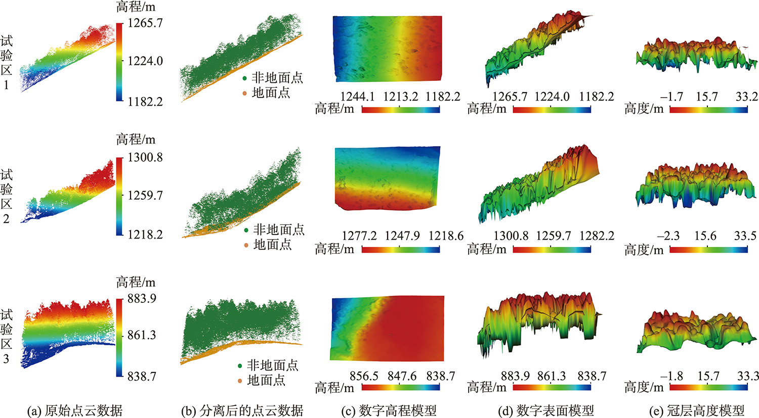
The retrieval of tree height is very important for growth status evaluation and biomass estimation. The Canopy Height Models (CHMs) are commonly used to extract the heights of individual trees. However, airborne LiDAR-derived CHMs are prone to distortion in areas with complex terrain, which significantly limits the extraction accuracy of individual tree height. Therefore, this study aimed to propose a new method, which simultaneously utilized the CHM and Digital Surface Model (DSM) to extract the heights of individual trees. Firstly, the CHM was generated from the preprocessed point clouds using Inverse Distance Weighted (IDW) interpolation algorithm. Secondly, the local maximum algorithm and Mark-Controlled Watershed Segmentation (MCWS) algorithm were adopted to segment the CHM, and thereafter obtain the individual tree crown contour polygon. Thirdly, the local maximum algorithm with a fixed window was applied to the DSM to detect the tree vertices and extract its elevation. Lastly, the tree height was obtained by subtracting the ground elevation obtained by Delaunay triangulation interpolation algorithm. Taking the coniferous forest near Fujiang Village, Xing'an County, Guangxi Province as the test area, this study analyzed the accuracy of tree heights obtained by CHM and our proposed method. For trees located at different test sites with the average terrain slopes of 32°, 25°, and 15°, the coefficients of determination (R2) values of the estimated tree heights based on CHMs are 0.84, 0.85, and 0.87, respectively, while the Root Mean Square Error (RMSE) values are 1.48, 1.41, and 1.58m, respectively. In contrast, the R 2 values of the tree height extracted from our method and the measured tree height are 0.92, 0.91, and 0.93, respectively, while the RMSE values are 0.93, 1.12, and 1.16 m, respectively. Compared with the CHM-based tree height extraction method, the R 2 of our method increased by 0.08, 0.06, and 0.06, respectively, while the RMSE values decreased by 0.55, 0.29, and 0.42m, respectively. The results indicated that, compared with the traditional method, our proposed method can significantly improve the estimation accuracy of individual tree height in areas with large terrain slopes.

ZHANG Haiqing , LI Xiangxin , WANG Cheng , XI Xiaohuan , WANG Pu , CHEN Zhengyu . Individual Tree Height Extraction from Airborne LiDAR Data by Combining with DSM[J]. Journal of Geo-information Science, 2021 , 23(10) : 1873 -1881 . DOI: 10.12082/dqxxkx.2021.210030
表1 基于标记控制分水岭分割的单木分割精度Tab. 1 Accuracy of single tree segmentation based on Mark-Controlled Watered Segmentation |
| 样地 | 总数 | 正确分割树木 | 过分割树木 | 漏分割树木 | AR/% | CE/% | OE/% |
|---|---|---|---|---|---|---|---|
| 试验区1 | 75 | 68 | 4 | 3 | 90.67 | 5.33 | 4.00 |
| 试验区2 | 78 | 67 | 3 | 8 | 85.90 | 3.85 | 10.25 |
| 试验区3 | 33 | 27 | 1 | 5 | 81.82 | 3.03 | 15.15 |
| 全部样区 | 186 | 162 | 8 | 16 | 87.10 | 4.30 | 8.60 |
表2 基于CHM、结合DSM与CHM 2种方法树高提取精度Tab. 2 Accuracy of tree height extraction with basing on CHM and combining CHM and DSM |
| 样地 | 树高获取 | 单木数量/棵 | 平均树高/m | 最小精度/% | 平均精度/% | 中值精度/% |
|---|---|---|---|---|---|---|
| 试验区1 | 实测值 | 68 | 26.53 | |||
| 基于CHM | 27.40 | 82.68 | 94.71 | 95.22 | ||
| 结合CHM与DSM | 26.19 | 89.88 | 96.94 | 97.56 | ||
| 试验区2 | 实测值 | 67 | 23.52 | |||
| 基于CHM | 24.07 | 84.91 | 94.91 | 95.44 | ||
| 结合CHM与DSM | 23.57 | 87.38 | 96.38 | 97.22 | ||
| 试验区3 | 实测值 | 27 | 26.92 | |||
| 基于CHM | 28.06 | 84.54 | 94.30 | 95.15 | ||
| 结合CHM与DSM | 26.08 | 88.10 | 95.99 | 96.44 |
表3 提取树高和实测树高的线性拟合结果Tab. 3 Linear fitting results of extracted tree height and measured tree height |
| 样地 | 方法 | 线性关系 | R2 | RMSE/m | NRMSE/% |
|---|---|---|---|---|---|
| 试验区1 | 基于CHM | Y=0.942x-0.723 | 0.84 | 1.48 | 5.58 |
| 结合CHM与DSM | Y=0.984x-0.741 | 0.92 | 0.93 | 3.51 | |
| 试验区2 | 基于CHM | Y=0.857x+2.874 | 0.85 | 1.41 | 5.98 |
| 结合CHM与DSM | Y=0.887x+2.620 | 0.91 | 1.02 | 4.33 | |
| 试验区3 | 基于CHM | Y=0.980x-0.587 | 0.87 | 1.58 | 5.88 |
| 结合CHM与DSM | Y=0.972x+1.561 | 0.93 | 1.16 | 4.31 |
| [1] |
夏永杰, 庞勇, 刘鲁霞, 等. 高精度DEM支持下的多时期航片杉木人工林树高生长监测[J]. 林业科学, 2019, 55(4):108-121.
[
|
| [2] |
焦义涛, 邢艳秋, 霍达, 等. 基于机载LiDAR点云估测林分的平均树高[J]. 西北林学院学报, 2015, 30(3):170-174.
[
|
| [3] |
|
| [4] |
庞勇, 赵峰, 李增元, 等. 机载激光雷达平均树高提取研究[J]. 遥感学报, 2008, 12(1):152-158.
[
|
| [5] |
鲁林, 周小成, 余治忠, 等. 随机森林算法在机载LiDAR数据林分平均树高估算中的应用研究[J]. 地球信息科学学报, 2016, 18(8):1133-1140.
[
|
| [6] |
王轶夫, 岳天祥, 赵明伟, 等. 机载LIDAR数据的树高识别算法与应用分析[J]. 地球信息科学学报, 2014, 16(6):958-964.
[
|
| [7] |
王欣, 陈传法. LiDAR森林冠层高度模型凹坑去除方法[J]. 测绘科学, 2016, 41(12):157-161.
[
|
| [8] |
|
| [9] |
|
| [10] |
|
| [11] |
杨雨薇, 李幸刚, 张亚萍. 基于图像的重建点云离群点检测算法[J]. 数据采集与处理, 2018, 33(5):928-935.
[
|
| [12] |
朱笑笑, 王成, 习晓环, 等. 多级移动曲面拟合的自适应阈值点云滤波方法[J]. 测绘学报, 2018, 47(2):153-160.
[
|
| [13] |
张锦明, 郭丽萍, 张小丹. 反距离加权插值算法中插值参数对DEM插值误差的影响[J]. 测绘科学技术学报, 2012, 29(1):51-56.
[
|
| [14] |
|
| [15] |
|
| [16] |
|
| [17] |
郭昱杉, 刘庆生, 刘高焕, 等. 基于标记控制分水岭分割方法的高分辨率遥感影像单木树冠提取[J]. 地球信息科学学报, 2016, 18(9):1259-1266.
[
|
| [18] |
|
| [19] |
李祥, 吴金卓, 林文树, 等. 一种高郁闭度林分树高的估测方法[J]. 测绘科学, 2019, 44(7):128-134.
[
|
| [20] |
|
| [21] |
陈日强, 李长春, 杨贵军, 等. 无人机机载激光雷达提取果树单木树冠信息[J]. 农业工程学报, 2020, 36(22):50-59.
[
|
| [22] |
陶惠林, 徐良骥, 冯海宽, 等. 基于无人机数码影像的冬小麦株高和生物量估算[J]. 农业工程学报, 2019, 35(19):107-116.
[
|
/
| 〈 |
|
〉 |