
Journal of Geo-information Science >
Integrating Height Features for Multi-scale Urban Building Type Classification from High-Resolution Remote Sensing Images
Received date: 2021-07-01
Request revised date: 2021-08-26
Online published: 2022-01-25
Supported by
National Natural Science Foundation of China, No(42001283)
Copyright
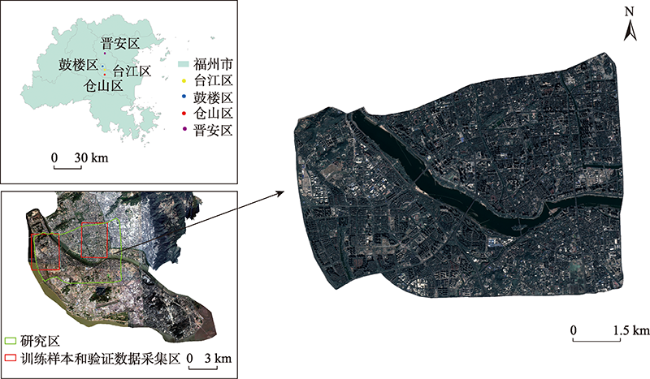
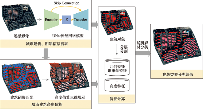
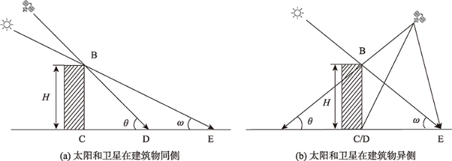
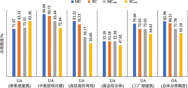
Urban building type information is crucial to many urban applications such as the identification of urban functional areas and estimation of urban environmental variables. This paper presents a new method to extract urban building types using multi-scale features and integrating height features derived from high resolution remote sensing images. We first conduct an image semantic segmentation to extract building and shadow objects from remote sensing images, and then estimate the height of buildings based upon the directional relationship of a building object and its shadow information. Following multi-scale image analysis concept, we extract a series of multi-scale features regarding the height, geometry, and spatial structure of building objects. Last, we use a machine learning method based upon random forest to classify building types. We also analyze the impact of different spatial units of building types on classification results. Experiments were conducted in Fuzhou, Fujian province, China, using a Chinese GF-2 satellite images acquired on February 18, 2020. Our results show that: (1) The overall accuracy of building type classification combined with multi-scale features reached 82.98%, and the kappa coefficient was 0.77, which was better than other conventional methods, namely a Multi-scale Classification Without Height Features (MCNH), a Single-scale Classification Incorporating Height Features (SC), and a Single-scale Classification Without Height Features (SCNH) in this paper; (2) The classification accuracy of middle-low residential buildings and high-rise commercial and residential buildings was improved by adding height features. Compared with classification results without using height features, the overall accuracy was improved by 11.28%; (3) The fusion of image features at multiple scales can reduce the misclassification of adjacent buildings into dense buildings. Compared with a single-scale classification method, the proposed method improved overall accuracy by 2.77%. We conclude that the use of high-resolution remote sensing images provides an effective strategy to estimate building heights based upon shadow information and improves the classification accuracy of urban building types, particularly when detailed digital surface model data are absent. In addition, the fusion of multi-scale image features can improve the characterization of complex building types in urban areas and the subsequent classification accuracy accordingly. Nevertheless, we also observed that the results of classified building types were affected by the initial extraction of building information from high resolution remote sensing images, implying that a further improvement of building type classification can be done by improving the extraction methods, e.g., using a more advanced semantic segmentation model.

CHU Guozhong , LI Mengmeng , WANG Xiaoqin . Integrating Height Features for Multi-scale Urban Building Type Classification from High-Resolution Remote Sensing Images[J]. Journal of Geo-information Science, 2021 , 23(11) : 2073 -2085 . DOI: 10.12082/dqxxkx.2021.210365
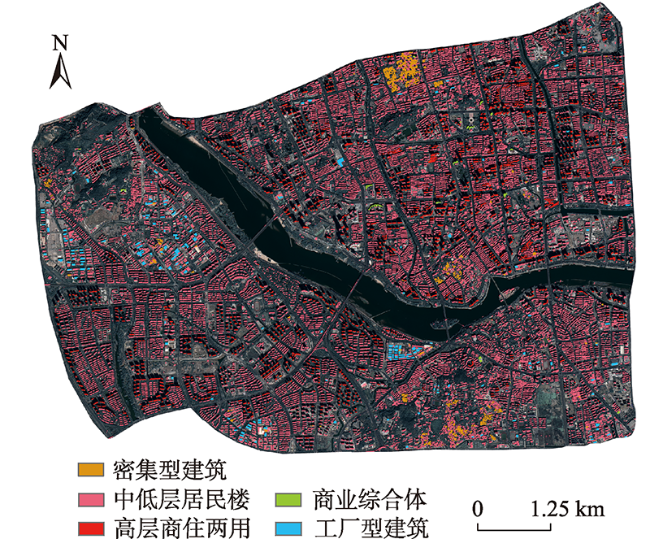
Tab. 1 Demonstration of building types |
| 建筑类型 | 影像示例 | 描述 |
|---|---|---|
| 密集型建筑(B1) | 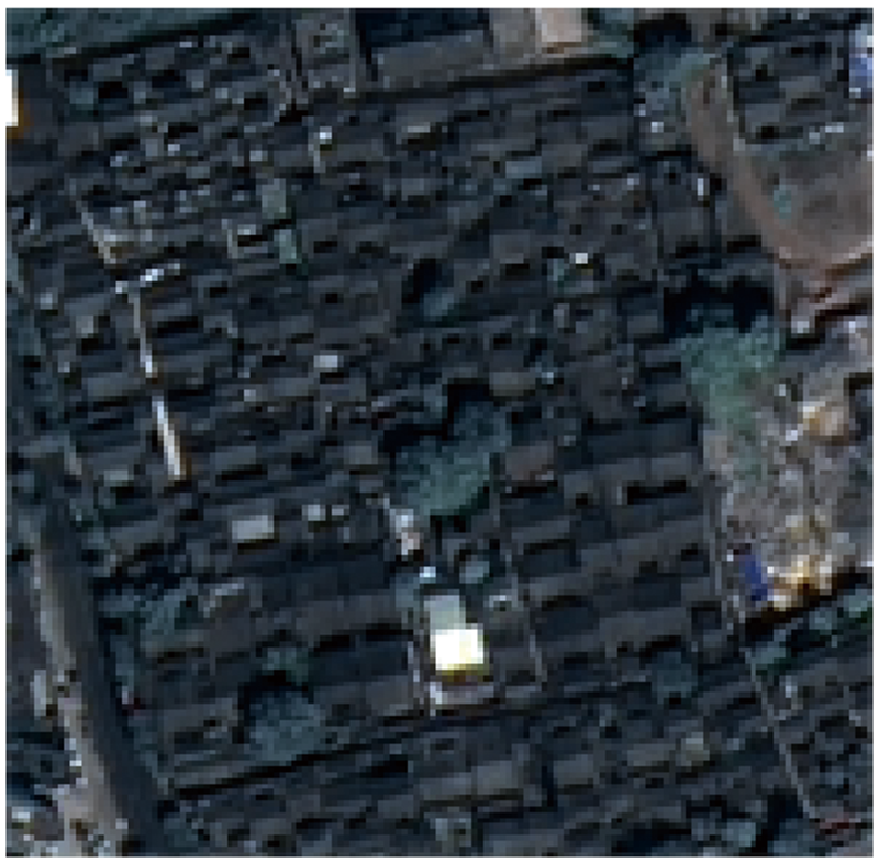 | 主要指一群邻接紧密的建筑群,在影像上难以描绘单个建筑对象,如老城区建筑、棚户区等,通常该类型建筑周边开放空间和植被覆盖密度较低 |
| 中低层居民楼(B2) | 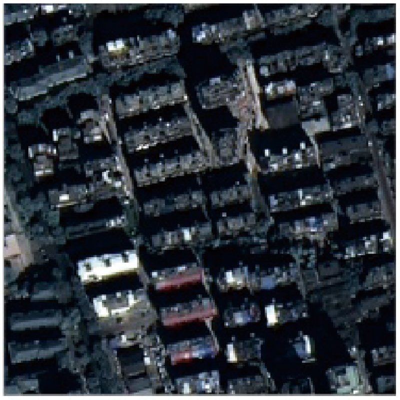 | 主要指中低层居民楼,在影像上通常具有相似的形状和大小,空间排列较规则,较密集型建筑具有较高的植被覆盖密度和开放空间 |
| 高层商住两用(B3) | 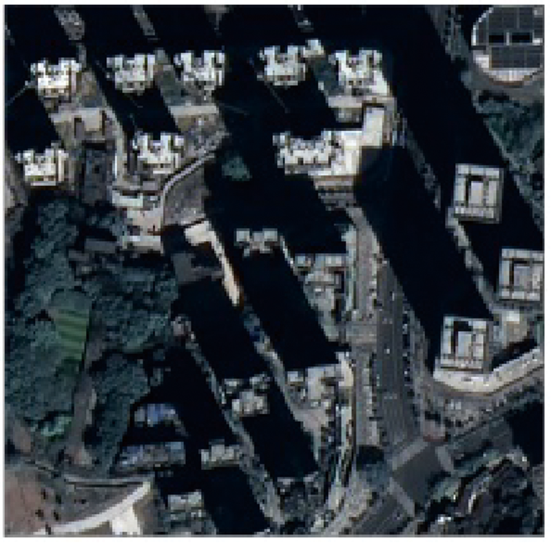 | 主要指高层居民楼和高层商业楼,在影像上和中低层居民楼有相似的视觉效果,但楼层较高,往往邻接着完整规则的阴影 |
| 商业综合体(B4) | 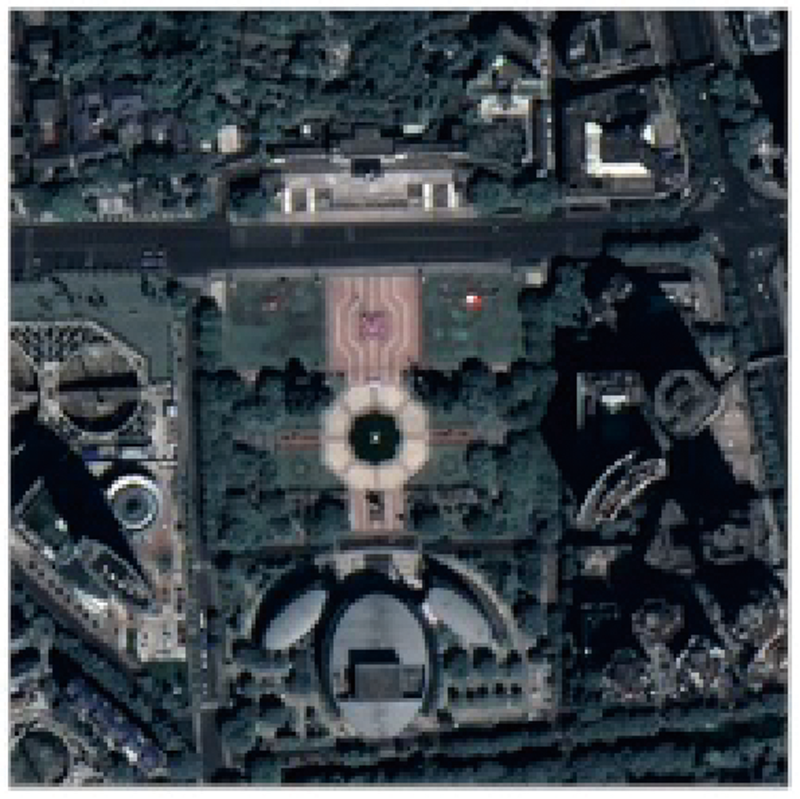 | 主要指用于商业服务或办公的复合型建筑,该类型建筑往往形状不规则、高低错落,和居民楼相比面积较大,周围存在更多的开放空间 |
| 工厂型建筑(B5) | 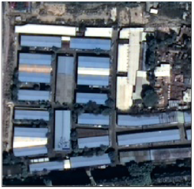 | 主要指用于工业或仓库存储的工厂,较居民楼有更大的面积;与商业型建筑相比,建筑形状更规则,光谱响应更均匀 |
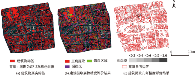
表2 建筑提取精度评价指标Tab. 2 Accuracy evaluation measures of building extraction |
| 评价指标 | 计算公式 | 编号 | 描述 |
|---|---|---|---|
| 总体精度(OA) | (8) | TP(True Positive)是分类正确的类; FP(False Positive)是被错分为正类的负类; TN(True Negative)是分类准确的负类; FN(False Negative)是被错分为负类的正类; 为指定类别分类对象的数量; 为重叠参考对象的数量; 表示某类别分类对象和参考对象的重叠面积; 、 、 计算 如下: (16) (17) (18) | |
| 交并比(IoU) | (9) | ||
| 召回率(Recall) | (10) | ||
| 准确率(Precision) | (11) | ||
| F1分数(F1 Score) | (12) | ||
| 全局过分误差(GOC) | (13) | ||
| 全局欠分误差(GUC) | (14) | ||
| 全局总体误差(GTC) | (15) |
| [1] |
|
| [2] |
|
| [3] |
|
| [4] |
|
| [5] |
|
| [6] |
|
| [7] |
宫鹏, 黎夏, 徐冰. 高分辨率影像解译理论与应用方法中的一些研究问题[J]. 遥感学报, 2006, 10(1):1-5.
[
|
| [8] |
李德仁, 眭海刚, 单杰. 论地理国情监测的技术支撑[J]. 武汉大学学报·信息科学版, 2012, 37(5):505-512.
[
|
| [9] |
|
| [10] |
周培诚, 程塨, 姚西文, 等. 高分辨率遥感影像解译中的机器学习范式[J]. 遥感学报, 2021, 25(1):182-197.
[
|
| [11] |
惠健, 秦其明, 许伟, 等. 基于多任务学习的高分辨率遥感影像建筑实例分割[J]. 北京大学学报(自然科学版), 2019, 55(6):1067-1077.
[
|
| [12] |
朱盼盼, 李帅朋, 张立强, 等. 基于多任务学习的高分辨率遥感影像建筑提取[J]. 地球信息科学学报, 2021, 23(3):514-523.
[
|
| [13] |
张浩然, 赵江洪, 张晓光. 利用U-net网络的高分遥感影像建筑提取方法[J]. 遥感信息, 2020, 35(3):143-150.
[
|
| [14] |
|
| [15] |
|
| [16] |
|
| [17] |
|
| [18] |
赵传, 郭海涛, 卢俊, 等. 结合区域增长与RANSAC的机载LiDAR点云屋顶面分割[J]. 测绘学报, 2021, 50(5):621-633.
[
|
| [19] |
郭峰, 毛政元, 邹为彬, 等 .融合 LiDAR 数据与高分影像特征信息的建筑物提取方法[J]. 地球信息科学学报, 2020, 22(8):1654-1665.
[
|
| [20] |
|
| [21] |
|
| [22] |
|
| [23] |
|
| [24] |
|
| [25] |
|
| [26] |
|
| [27] |
|
| [28] |
|
| [29] |
付乾坤, 吴波, 汪小钦, 等. 基于形态学建筑物指数的城市建筑物提取及其高度估算[J]. 遥感技术与应用, 2015, 30(1):148-154.
[
|
| [30] |
石义方, 汪小钦, 孙振海, 等. 基于阴影的资源三号卫星数据城市建筑物高度估算[J]. 地球信息科学学报, 2015, 17(2):236-243.
[
|
| [31] |
|
| [32] |
|
| [33] |
|
| [34] |
|
| [35] |
|
| [36] |
|
/
| 〈 |
|
〉 |