
Journal of Geo-information Science >
Green View Index Estimation Method based on Three-dimensional Simulation of Urban Tree Landscape
Received date: 2021-02-03
Request revised date: 2021-05-05
Online published: 2022-02-25
Supported by
National Natural Science Foundation of China(41971344)
Copyright
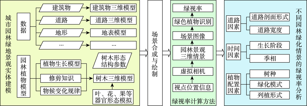
Urban ecological landscape has sensory functions, which describe the visual effect of green plants for human beings. Green view index is considered as a relatively good indicator for measuring the visibility of urban green space, which can reflect different levels of urban vegetation space directly. Green view index is usually calculated using static images or street view data. However, green view index is a variable quantity since the variant of view point location results with very different visual effects and the phenological change of plants. What is more, plants, as organism with life characteristics, are the most important elements in the urban green space landscape, which can change their morphology with time factors constantly and affect the amount of visible green space. In the paper, a green view index calculation method was proposed based on the three-dimensional simulation landscape of garden trees driven by spatial information data of geographic entities and tree architecture and growth model. This method comprises three steps. Firstly, using virtual geographical environment, virtual plants, and other technologies, a three-dimensional urban vegetation landscape was generated according to hard landscape data (e.g. roads, building) and tree models. Secondly, based on visual mechanisms of seeing, virtual cameras were constructed to set observation points and generate the landscape visual images. Thirdly, the visibility analysis was conducted to identify vegetation information visible from each observation point at the pixel level, which can compute the value of green view index. A three-dimensional tree landscape simulation and green view index estimation prototype was developed. Taking urban road greenery scenes (e.g. Jinshan avenue in Fuzhou) as an example, the green view index was estimated and analyzed. The results are closed to those derived from street view images. Therefore, it can effectively reflect the visual feeling of vehicle passengers. It is useful for quantitatively evaluating the visual effects of urban forest states of past, present, or future at different growth stages. It is also suitable to simulate and calculate green view index dynamically by setting view points everywhere and in arbitrary directions. The method can be used as a potential tool to assess the simulation results of urban green space design schemes before they were carried out. It is also helpful for the rational planning of urban green space. It can provide references for the science and rationality of the future landscape of different engineering design schemes, thereby promoting the sustainable development of the city.

JIANG Feng , TANG Liyu , LIN Ding , CHEN Xiaoling , FENG Xianchao , CHEN Chongcheng . Green View Index Estimation Method based on Three-dimensional Simulation of Urban Tree Landscape[J]. Journal of Geo-information Science, 2021 , 23(12) : 2151 -2162 . DOI: 10.12082/dqxxkx.2021.210063
表1 不同年龄的香樟形态参数Tab. 1 Morphological parameters of Cinnamomum camphora at different ages |
| 年龄/年 | 胸径/cm | 树高/m | 冠幅/m | 冠高/m |
|---|---|---|---|---|
| 10 | 9.43 | 4.29 | 3.11 | 1.73 |
| 15 | 15.1 | 6.98 | 4.85 | 3.72 |
| 20 | 20.71 | 9.47 | 6.57 | 6.44 |
| [1] |
|
| [2] |
|
| [3] |
张云路, 关海莉, 李雄. 从园林城市到生态园林城市的城市绿地系统规划响应[J]. 中国园林, 2017, 33(2):71-77.
[
|
| [4] |
周坚华. 城市绿量测算模式及信息系统[J]. 地理学报, 2001, 56(1):14-23.
[
|
| [5] |
周坚华, 孙天纵. 三维绿色生物量的遥感模式研究与绿化环境效益估算[J]. 环境遥感, 1995, 10(3):162-174.
[
|
| [6] |
张佳晖, 孟庆岩, 孙云晓, 等. 城市行道树绿视量指数研究[J]. 地球信息科学学报, 2017, 19(6):838-845.
[
|
| [7] |
孟庆岩, 汪雪淼, 孙云晓, 等. 基于街景数据的绿视率模型构建及其影响因子研究[J]. 生态科学, 2020, 39(1):146-155.
[
|
| [8] |
青木陽二. 視野の広がりと緑量感の関連[J]. 造園雑誌, 1987, 51(1):1-10.
[
|
| [9] |
李渊, 黄竞雄. 基于绿视衰减曲线的历史街区步行环境绿视感知评价——以厦门市中山路同文片区为例[J]. 风景园林, 2020, 27(11):110-115.
[
|
| [10] |
王洋洋, 黄锦楼. 基于绿视率的城市生态舒适度评价模型构建[J]. 生态学报, 2021(6):1-10.
[
|
| [11] |
张炜, 周昱杏, 杨梦琪. 全景绿视率自动识别和计算研究[J]. 风景园林, 2019, 26(10):89-94.
[
|
| [12] |
|
| [13] |
|
| [14] |
陈亚萍, 郑伯红, 曾祥平. 基于街景和遥感影像的城市绿地多维度量化研究——以郴州市为例[J]. 经济地理, 2019, 39(12):80-87.
[
|
| [15] |
|
| [16] |
|
| [17] |
|
| [18] |
林珲, 胡明远, 陈旻, 等. 从地理信息系统到虚拟地理环境的认知转变[J]. 地球信息科学学报, 2020, 22(4):662-672.
[
|
| [19] |
|
| [20] |
|
| [21] |
潘远智, 车代弟. 风景园林植物学[M]. 北京: 中国林业出版社, 2018.
[
|
| [22] |
冯志坚. 园林植物学:南方版[M]. 重庆: 重庆大学出版社, 2013.
[
|
| [23] |
|
| [24] |
林定, 陈崇成, 唐丽玉, 等. 基于颜色编码的虚拟树木交互式修剪技术及其实现[J]. 计算机辅助设计与图形学学报, 2011, 23(11):1799-1807.
[
|
| [25] |
|
| [26] |
中国科学院中国植物志编辑委员会. 中国植物志[M]. 北京: 科学出版社, 1993.
[ Editorial Committee of Flora of China, Chinese Academy of Sciences. Flora of China[M]. Beijing: Science Publishing, 1993. ]
|
| [27] |
张杰伟. 合肥市三种常绿园林树木生长模型的研究[D]. 合肥:安徽农业大学, 2010.
[
|
| [28] |
王旭东, 杨秋生, 张庆费. 常见园林树种树冠尺度定量化研究[J]. 中国园林, 2016, 32(10):73-77.
[
|
| [29] |
|
| [30] |
肖希, 韦怡凯, 李敏. 日本城市绿视率计量方法与评价应用[J]. 国际城市规划, 2018, 33(2):98-103.
[
|
| [31] |
王秀娟. 城市园林绿地规划[M]. 北京: 化学工业出版社, 2009.
[
|
| [32] |
苏雪痕. 植物景观规划设计[M]. 北京: 中国林业出版社, 2012.
[
|
| [33] |
李军成. 基于绿视率的重庆新建城市道路绿化设计模式研究[D]. 重庆:西南大学, 2012.
[
|
| [34] |
李明霞. 基于绿视率的城市街道步行空间绿量视觉评估[D]. 北京:中国林业科学研究院, 2018.
[
|
| [35] |
|
/
| 〈 |
|
〉 |