
Journal of Geo-information Science >
Research on the Deficiency and Extension of OGC SLD/SE Standard in Thematic Cartography
Received date: 2021-03-08
Request revised date: 2021-06-22
Online published: 2022-04-25
Copyright
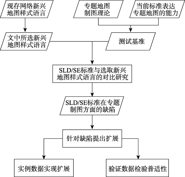
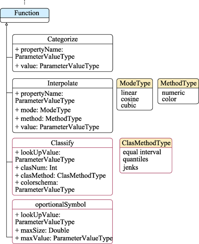
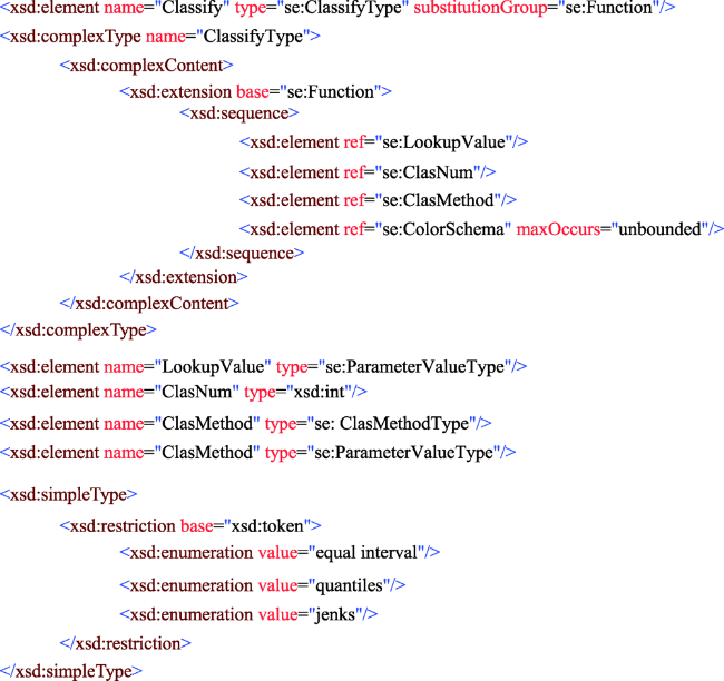
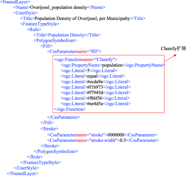
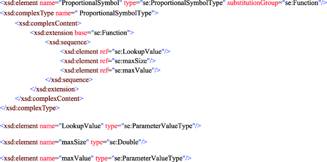
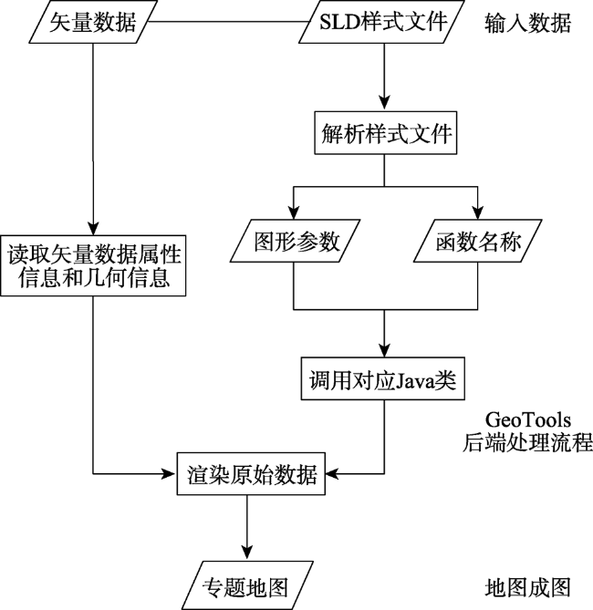
Nowadays, web cartography or web mapping has become an important direction for the development of web GIS. The production of thematic maps on the web is extremely important. The SLD/SE standard proposed by the OGC is currently the standard and specification of web mapping. However, SLD/SE standard is often at a fundamental level, which leads to poor quality of maps. With web cartography development, besides the SLD/SE standard, some new web styling languages are emerging. Compared with the SLD/SE standard, the emerging map styling languages have advantages in making thematic maps. This research selects Mapbox GL and CartoCSS from the existing emerging map styling languages for comparison with the SLD/SE standard, and then summarizes the defects of the SLD/SE standard in expressing thematic maps. The study found that the SLD/SE standard lacks the function of setting a classification method. Meanwhile, it also lacks the function of accurately expressing the unclassified proportional symbol map. Because of the shortcomings, this study proposed the extensions of Classify and ProportionalSymbol. Example data of Overijssel province in Netherlands were used to prove that the new extensions were feasible, while the verification data of Beijing were used to prove that the extensions were applicable to all vector data used to create thematic maps. The SLD/SE standard is still in the stage of continuous development. In future standardisation, the two extensions proposed in this research can greatly simplify the work of cartographers and improve the ability of current standard to express unclassified proportional symbol maps.

Key words: OGC; SLD/SE standard; thematic maps; extensions; emerging styling languages
TIAN Xin , ZHAO Wenji . Research on the Deficiency and Extension of OGC SLD/SE Standard in Thematic Cartography[J]. Journal of Geo-information Science, 2022 , 24(2) : 352 -364 . DOI: 10.12082/dqxxkx.2022.210114
表1 网络现存新兴地图样式语言及其使用平台Tab. 1 Online mapping platforms and their styling languages |
| 新兴样式语言(编码格式) | 使用的网络制图平台 |
|---|---|
| MapCSS (类CSS格式) | OpenStreetMap |
| CartoCSS (类CSS格式) | OpenStreetMap、Carto |
| Mapbox GL (基于JSON格式) | Mapbox,Kepler.gl,Deck.gl,Luma.gl,react-map-gl |
表2 SLD/SE标准、CartoCSS和Mapbox GL的区别Tab. 2 Online mapping platforms and their styling languages |
| 地图样式语言 | 编码格式 | 优势 | 劣势 |
|---|---|---|---|
| SLD/SE标准 | XML格式 | 可扩展性、可互操作性 | 编码冗长,样式定义单一 |
| CartoCSS | 类CSS格式 | 编码简短,易读性强 | 缺乏可互操作性 |
| Mapbox GL | 基于JSON格式 | 编码简洁,易读性强 数据驱动编码利于处理矢量图层的属性信息 | 缺乏可互操作性 |
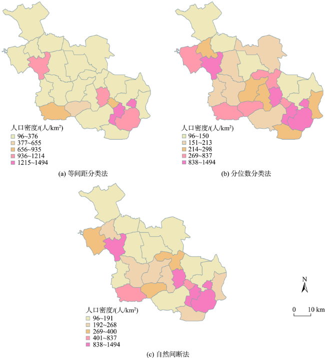
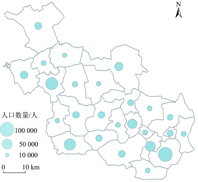
表3 当前SLD/SE标准描绘专题地图的能力Tab. 3 The ability of the current standard to express thematic maps |
| 专题地图类型 | 是否能被SLD/SE标准描绘 | |
|---|---|---|
| 分区着色图 | 是 | |
| 分级统计图 | 分类的 | 是 |
| 未分类的 | 是 | |
| 比例符号图 | 分类的 | 是 |
| 未分类的 | 是 | |
| 图表统计图 | 否 | |
| 价值-区域图 | 否 | |
| 叠置符号图 | 是 | |
| 并置符号图 | 否 | |
| 点密度图 | 否 | |
| 标准等值线图 | 是 | |
| 等值区填充图 | 否 | |
| 流向图 | 否 | |
表4 3种地图样式语言中用于描绘基准的机制Tab. 4 The mechanisms used to express three benchmarks in the three styling languages |
| 基准 | SLD/SE | CartoCSS | Mapbox GL | |||
|---|---|---|---|---|---|---|
| 分区统计图 | 分类的 | <Rule>元素和 <Filter>元素 | Filters | Case语句 | ||
| Categories函数 | Ramp()函数 | Step函数 | ||||
| 未分类的 | Interpolation函数 | - | Interpolation函数 | |||
| 为每一属性值设置对应颜色 | ||||||
| 比例符号图 | 分类的 | <Rule>元素和<Filter>元素 | Filters | Case语句 | ||
| Categories函数 | Ramp()函数 | Step函数 | ||||
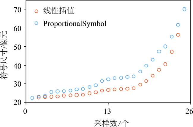
| 未分类的 | Interpolation函数 | - | Sqrt()函数 | |||
| 为每一属性值设置对应符号大小 | ||||||
| 图表统计图 | 不包含可表达该类型专题地图的机制 | |||||
| 等值线填充图 | 不包含可表达该类型专题地图的机制 | |||||
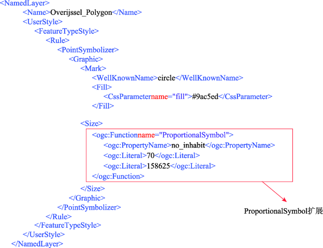
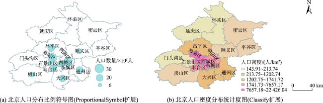
图10 ProportionalSymbol扩展函数描绘的荷兰上艾瑟尔省人口分布比例符号图Fig. 10 Proportional symbol map expressed by ProportionalSybmol extension, it shows the population of Overijssel province in Netherlands |
| [1] |
OGC. The Home of Location Technology Innovation and Collaboration[EB/OL]. 2021. from https://www.ogc.org/.
|
| [2] |
王金传. 基于OGC标准的分布式地理信息服务链构建方法研究[D]. 济南:山东师范大学, 2019.
[
|
| [3] |
|
| [4] |
|
| [5] |
|
| [6] |
|
| [7] |
|
| [8] |
|
| [9] |
|
| [10] |
|
| [11] |
|
| [12] |
|
| [13] |
亢孟军, 徐召硕, 朱军, 等. 一种数据驱动的专题地图自动编制方法[J/OL]. 测绘科学, 2021:1-9.
[
|
| [14] |
|
| [15] |
詹梅香. 专题地图符号表示方法的探讨[J]. 现代测绘, 2010, 33(1):57-58,61.
[
|
| [16] |
Mapbox. COVID-19[EB/OL]. 2020. from https://www.mapbox.cn/coronavirusmap/#3.35/28.47/109.74.
|
| [17] |
|
| [18] |
|
| [19] |
Mapbox. Mapbox style specification[EB/OL]. https://docs.mapbox.com/mapbox-gl-js/style-spec/.
|
| [20] |
Carto. Styling[EB/OL]. https://carto.com/developers/styling/cartocss/.
|
| [21] |
OpenStreetMap. MapCSS/0.2[EB/OL]. 2017. https://wiki.openstreetmap.org/wiki/MapCSS/0.2.
|
| [22] |
|
| [23] |
|
| [24] |
|
| [25] |
|
| [26] |
|
| [27] |
|
| [28] |
Mapbox. Thematic map types[EB/OL]. https://labs.mapbox.com/education/thematic-map-types/.
|
| [29] |
|
| [30] |
|
| [31] |
|
| [32] |
|
| [33] |
|
| [34] |
|
| [35] |
|
| [36] |
OSGF. GeoServer is an open source server for sharing geospatial data[EB/OL]. 2021. http://geoserver.org/.
|
| [37] |
Mapbox. Design beautiful maps with Mapbox Studio[EB/OL]. 2021. https://www.mapbox.com/mapbox-studio.
|
| [38] |
Carto. Unlock the power of spatial analysis[EB/OL]. 2021. https://carto.com/.
|
/
| 〈 |
|
〉 |