
Journal of Geo-information Science >
Automatic Extraction of River Source Region Boundary based on Multi-Characteristic Indexes and Hierarchical Cluster Analysis
Received date: 2021-06-14
Request revised date: 2021-08-12
Online published: 2022-05-25
Supported by
National Natural Science Foundation of China(42071393)
National Key Research and Development Program of China(2016YFC0500206)
National Key Research and Development Program of China(2017YFC0506506)
Copyright
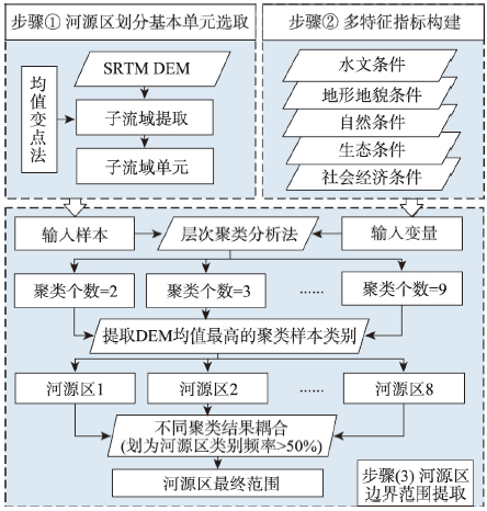
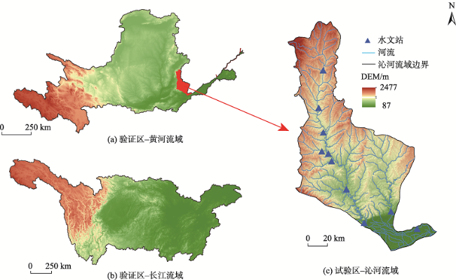
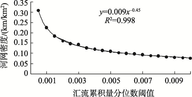
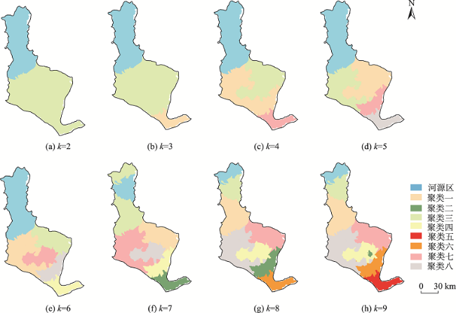
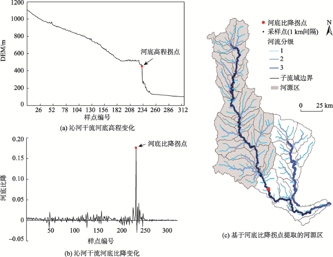
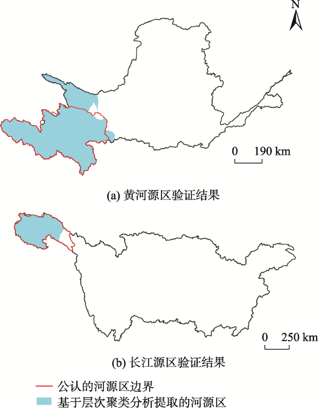
The boundary of river source region is a kind of important and fundamental national geographical information. Apart from the available river source region boundary information for major rivers such as the Yangtze river and the Yellow River, many middle and small-sized river basins in China still lack explicit and detailed river source region boundary information at present. Thus, it is necessary to scientifically and reasonably delineate the river source region boundary to support the implementation of water-related ecological protection and compensation policy. In this paper, based on established principles for identifying river source region, we proposed a method for river source region boundary demarcation based on multi-characteristic indexes and hierarchical clustering analysis. The Qinhe River Basin was taken as a case study area. Firstly, we utilized mean change point analysis to determine the optimal quantile threshold (0.15%) of flow accumulation to extract sub-catchments units of Qinhe River Basin. Then, the boundary of its river source region was determined by hierarchical clustering analysis based on the multi-characteristic indexes of sub-catchments. The method was also applied to the Yangtze River and Yellow River basins for verification analysis. The results are as follows: (1) The area of the source area of Qinhe River basin based on multi-characteristic indexes and hierarchical cluster analysis was between that obtained by the slope inflection point and hydrological station method; (2) In the Yangtze river basin and the Yellow River basin, the IoU (Intersection over Union) results of this method reached 85.40% and 79.99%, respectively, which indicates that this method is applicable to the extraction of source regions. To summarize, the automatic extraction method for river source region boundary information we proposed could simply and efficiently identify large, middle, and small river source regions’ boundary, which provides scientific support for the identification of ecological security barriers and the implementation of water resources protection policies in China's river source regions.
DENG Yawen , HOU Peng , JIANG Weiguo , PENG Kaifeng , LI Zhuo , DENG Yue . Automatic Extraction of River Source Region Boundary based on Multi-Characteristic Indexes and Hierarchical Cluster Analysis[J]. Journal of Geo-information Science, 2022 , 24(3) : 469 -482 . DOI: 10.12082/dqxxkx.2022.210334
表1 河源区划分原则Tab. 1 Principles for identifying river source region |
| 河源区划分原则 | 具体说明 |
|---|---|
| 保证河源区包含河流源头[24,25] | 河流源区的界定首先要弄清楚其源头,源头的判定一般考虑河流支流中流量最大、集水面积最大、河流最长者确定为主流,其源头确定为正源,河源区应该包含河流的源头 |
| 地形地貌单元的完整性[17] | 这一原则突出了河源区范围的界定要便于生态环境的研究,且地形地貌对水文水系分布特征影响较大 |
| 生态环境主成分的趋同性[17] | 河源区内部的气候、植被等生态环境要素差异不能过大,在进行河源区划分时必须全面考虑构成其生态环境的各种要素的相似性,保证所划分出的河源区域是一种具有自身特点的综合体 |
| 共轭性原则[26,27] | 这一原则要求划分出的区域是连续的地域单元,不能有空间上存在于某区域之外,但又属于该区的分区单元 |
| 保持分水岭边界的完整性[17] | 考虑到河源区与水系分布密切相关,因而首先考虑保持分水岭边界的完整性,故研究中以流域内子流域单元为基本河源区基本划分单元 |
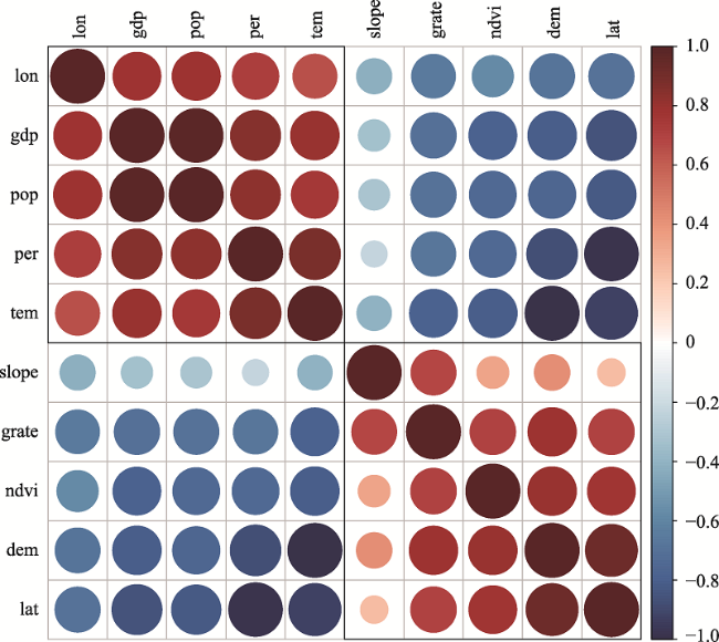
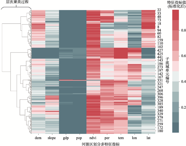
表2 河源区划分多特征指标体系Tab. 2 Multi-characteristic Indexes for river source region boundary extraction |
| 分类 | 指标名称 | 指标含义或说明 |
|---|---|---|
| 水文条件 | 汇流累积量 | 区域内每点的汇流累积栅格数量 |
| 河网密度/(km/km²) | 单位面积内的河网长度 | |
| 地形地貌条件 | 高程/m | 某点到基准面的距离 |
| 坡度/° | 坡面的垂直高度和水平方向距离的比值 | |
| 自然条件 | 年降水量/mm | 一年中降水量的总和 |
| 年平均气温/℃ | 一年气温的平均值 | |
| 生态条件 | 植被覆盖面积比重/% | 林地、草地和灌木面积占土地总面积比重 |
| NDVI(归一化差值植被指数) | 近红外通道与可见光通道反射率之差与之和的商 | |
| 社会经济条件 | 人口密度/(人/km²) | 人口总量/土地总面积 |
| GDP总产值/万元/km² | GDP总产量/土地总面积 |
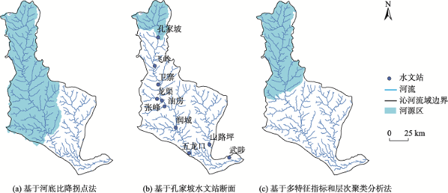
图10 3种方法得到的河源区范围对比Fig. 10 Comparison of the river source region boundary obtained by the three methods |
表3 不同河源区识别方法对比分析Tab. 3 Comparison and analysis of different river source region boundary identification methods |
| 方法 | 主要原理 | 优点 | 局限性 | 适用场景 |
|---|---|---|---|---|
| 基于河底比降拐点 | 河底高程剧烈变化处为断点 | 地形地貌特征表征程度强 | 在某些流域不具有 适用性 | 河底比降变化明显的山丘区流域 |
| 基于水文站点 | 水文站点对应的集水区域 | 简单直观 | 主观性强,不确定性 较大 | 较为公认的流域河源区,用于河源区河流、流量径流分析 |
| 本文方法 | 基于多特征指标与层次聚类分析 | 较为客观、简捷高效、自动化识别 | 未进行更多流域的验证、存在一定不确定性 | 山丘区、平原区域中未确定河源区范围的流域 |
| [1] |
郭新亚, 杜世勋, 宁婷, 等. 沁河源区水源涵养功能辐射效益研究[J]. 水土保持研究, 2018, 25(6):365-369,376.
[
|
| [2] |
王浩, 王琳. 我国江河源头区水生态保护战略[J]. 中国水利, 2017(17):15-18.
[
|
| [3] |
|
| [4] |
|
| [5] |
|
| [6] |
|
| [7] |
|
| [8] |
|
| [9] |
陈琼, 张镱锂, 刘峰贵, 等. 黄河流域河源区土地利用变化及其影响研究综述[J]. 资源科学, 2020, 42(3):446-459.
[
|
| [10] |
文萌, 张新华, 黄火建, 等. 江河源头区范围划定方法研究[J]. 水力发电, 2019, 45(12):1-6.
[
|
| [11] |
王浩. 江河源头区水生态保护战略:上蓄、限牧、调农、补偿[J]. 中国水利, 2017(17):10.
[
|
| [12] |
|
| [13] |
|
| [14] |
李贝贝, 李志威, 胡旭跃, 等. 长江源区河网纵剖面分析[J]. 山地学报, 2018, 36(3):470-481.
[
|
| [15] |
陈利群, 刘昌明, 郝芳华, 等. 黄河源区气候对径流的影响分析[J]. 地学前缘, 2006, 13(5):321-329.
[
|
| [16] |
|
| [17] |
丁永建, 杨建平, 刘时银, 等. 长江黄河源区生态环境范围的探讨[J]. 地理学报, 2003, 58(4):519-526.
[
|
| [18] |
孔凡哲, 李莉莉. 利用DEM提取河网时集水面积阈值的确定[J]. 水电能源科学, 2005, 23(4):65-67,93.
[
|
| [19] |
杨锦玲. 基于分形的数字水系集水面积阈值确定研究[J]. 测绘科学, 2011, 36(4):33-34.
[
|
| [20] |
杨邦, 任立良. 集水面积阈值确定方法的比较研究[J]. 水电能源科学, 2009, 27(5):11-14,171.
[
|
| [21] |
赖晗, 芮小平, 梁汉东, 等. 基于均值变点分析的三峡库区河网提取研究[J]. 测绘科学, 2012, 37(5):173-175.
[
|
| [22] |
常直杨, 王建, 白世彪, 等. 均值变点分析法在最佳集水面积阈值确定中的应用[J]. 南京师大学报(自然科学版), 2014, 37(1):147-150.
[
|
| [23] |
徐新良, 庄大方, 贾绍凤, 等. GIS环境下基于DEM的中国流域自动提取方法[J]. 长江流域资源与环境, 2004, 13(4):343-348.
[
|
| [24] |
冯永忠, 杨改河, 杨世琦, 等. 江河源区地域界定研究[J]. 西北农林科技大学学报(自然科学版), 2004, 32(1):11-14.
[
|
| [25] |
陈进, 许珍. 以三江源为例探讨江河源头确定原则[J]. 长江科学院院报, 2016, 33(3):23-28.
[
|
| [26] |
冯永忠, 朱芬萌, 王得祥, 等. 江河源区生态地理区划[J]. 西北农林科技大学学报(自然科学版), 2004, 32(2):1-4.
[
|
| [27] |
陈晓红, 王玉娟, 万鲁河, 等. 基于层次聚类分析东北地区生态农业区划研究[J]. 经济地理, 2012, 32(1):137-140.
[
|
| [28] |
杨志恒. 基于Ward法的区域空间聚类分析[J]. 中国人口·资源与环境, 2010, 20(S1):382-386.
[
|
| [29] |
刘超楠, 王山东. 基于Ward法的马鞍山市规划单元聚类分析[J]. 测绘与空间地理信息, 2015, 38(3):114-116.
[
|
/
| 〈 |
|
〉 |