
Journal of Geo-information Science >
A Synergistic Simplification Method of Contours of Natural Continuous Polygons
Received date: 2021-09-26
Revised date: 2021-10-25
Online published: 2022-06-25
Supported by
National Natural Science Foundation of China(41801313)
National Natural Science Foundation of China(41901397)
The Fund Project of ZhongYuan Scholar of Henan Province(202101510001)
Copyright
The simplification of contours of natural continuous polygons is an important step of automatic cartographic generalization of natural polygons in topographic map and natural patches in general survey of geographical conditions. Most of the existing simplification algorithms of polygonal contours are based on the line simplification algorithms, which cannot effectively simplify bending features, maintain the area balance, and meet the requirements of graphic visual clarity. Moreover, there are topological problems in the simplification result, such as inconsistent shared contour, self-intersection of contour and intersection between contours. Therefore, combined with the expression characteristics and simplification requirements of natural continuous polygons, a synergistic simplification method is proposed for the contours of natural continuous polygons. First, the natural continuous polygons are transformed into topological data structure, and the constrained Delaunay triangulation is constructed based on the arc segment to be simplified and its adjacent arc segments to identify the simplified region. Second, the arc segment bilateral hierarchical multiple tree model is used to gradually remove or partially remove narrow bends and simplify small bends. Third, the narrow regions are adaptively exaggerated to avoid unclear details on the map. The simplification experiment of Vegetation and Soil polygons in 1:50000 scale topographic map of a region in Henan, China was carried out. Compared with the reference methods, our proposed method can effectively maintain the topological consistency and area balance among natural continuous polygons before and after the simplification and fully simplify the invisible details under the target map scale, and the position accuracy of our simplification results meet the requirement. Therefore, the proposed method has better superiority in terms of topological consistency, visual clarity, and area balance.

ZHANG Fubing , SUN Qun , ZHU Xinming , MA Jingzhen . A Synergistic Simplification Method of Contours of Natural Continuous Polygons[J]. Journal of Geo-information Science, 2022 , 24(4) : 631 -642 . DOI: 10.12082/dqxxkx.2022.210582
图10 不同算法化简结果注:子图左下角的2个蓝色虚线圈为相应图上区域1和区域2的放大显示,其中红色线为化简结果,黑色线为原始边线。 Fig. 10 The simplification results of different algorithms |
表1 实验区域拓扑一致性保持结果Tab. 1 The results of topological consistency maintaining |
| 方法 | 1:10万 | 1:25万 | |||
|---|---|---|---|---|---|
| 存在边线自交 | 存在边线之间相交或相接 | 存在边线自交 | 存在边线之间相交或相接 | ||
| DP算法 | 是 | 否 | 是 | 是 | |
| 全局线化简算法 | 否 | 否 | 否 | 否 | |
| 包络带化简算法 | 否 | 否 | 否 | 是 | |
| 本文方法 | 否 | 否 | 否 | 否 | |
表2 位置误差计算结果与化简效果对比Tab. 2 Location errors of simplification results and comparison of simplification effect |
| 方法 | 位置误差/m | 条带状弯曲 | 细小弯曲 | 狭窄“瓶颈” | |
|---|---|---|---|---|---|
| 1:10万 | 1:25万 | ||||
| DP算法 | 69.7 | 258.9 | 未退化 | 已化简 | 未夸大 |
| 全局线化简算法 | 14.5 | 42.0 | 部分退化 | 部分化简 | 未夸大 |
| 包络带化简算法 | 26.1 | 106.6 | 部分退化 | 已化简 | 未夸大 |
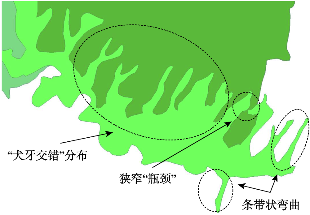
| 本文方法 | 26.4 | 216.6 | 退化 | 已化简 | 夸大 |
图11 面积变化率对比(1:10万)Fig. 11 Comparison of area change of simplification results at scale 1:100 000 |
图12 面积变化率对比(1:25万)Fig. 12 Comparison of area change of simplification results at scale 1:250 000 |
表3 平均面积变化率统计Tab. 3 Statistics of average area change rate |
| 方法 | 平均面积变化率/% | |
|---|---|---|
| 1:10万 | 1:25万 | |
| D-P算法 | -0.19 | -1.37 |
| 全局线化简算法 | -0.07 | -0.24 |
| 包络带化简算法 | 0.01 | 0.99 |
| 本文算法 | 0.02 | -0.96 |
| [1] |
武芳, 巩现勇, 杜佳威. 地图制图综合回顾与前望[J]. 测绘学报, 2017,46(10):1645-1664.
[
|
| [2] |
程绵绵, 孙群, 徐立, 等. 面轮廓线相似性和复杂性度量及在化简中的应用[J]. 测绘学报, 2019,48(4):489-501.
[
|
| [3] |
王光霞, 游雄, 於建峰. 地图设计与编绘[M]. 北京: 测绘出版社, 2011.
[
|
| [4] |
杜佳威, 武芳, 李靖涵, 等. 采用多元弯曲组划分的线要素化简方法[J]. 计算机辅助设计与图形学学报, 2017,29(12):2189-2196.
[
|
| [5] |
|
| [6] |
|
| [7] |
朱鲲鹏, 武芳, 王辉连, 等. Li-Openshaw算法的改进与评价[J]. 测绘学报, 2007,36(4):450-456.
[
|
| [8] |
金澄, 安晓亚, 崔海福, 等. 矢量瓦片地图线化简算法研究[J]. 地球信息科学学报, 2019,21(10):1502-1509.
[
|
| [9] |
李成名, 郭沛沛, 殷勇, 等. 一种顾及空间关系约束的线化简算法[J]. 测绘学报, 2017,46(4):498-506.
[
|
| [10] |
艾廷华, 郭仁忠, 刘耀林. 曲线弯曲深度层次结构的二叉树表达[J]. 测绘学报, 2001,30(4):343-348.
[
|
| [11] |
李靖涵, 武芳, 杜佳威, 等. Delaunay三角网支持下的海图等深线化简[J]. 武汉大学学报·信息科学版, 2019,44(5):778-783.
[
|
| [12] |
杜维, 艾廷华, 徐峥. 一种组合优化的多边形化简方法[J]. 武汉大学学报·信息科学版, 2004,29(6):548-550.
[
|
| [13] |
翟仁健, 武芳, 朱丽, 等. 曲线形态的结构化表达[J]. 测绘学报, 2009,38(2):175-182.
[
|
| [14] |
操震洲, 李满春, 程亮. 曲线弯曲的多叉树表达[J]. 测绘学报, 2013,42(4):602-607.
[
|
| [15] |
|
| [16] |
钱海忠, 何海威, 王骁, 等. 采用三元弯曲组划分的线要素化简方法[J]. 武汉大学学报·信息科学版, 2017,42(8):1096-1103.
[
|
| [17] |
|
| [18] |
|
| [19] |
|
| [20] |
|
| [21] |
|
| [22] |
|
| [23] |
胡凤敏, 卢小平, 李成名, 等. 一种顾及图斑拓扑关系的化简方法[J]. 测绘通报, 2017(6):49-52.
[
|
| [24] |
|
| [25] |
|
| [26] |
张立华, 唐露露, 贾帅东, 等. 多条海岸线协同化简的层次化三角网分区法[J]. 测绘学报, 2019,48(4):520-531.
[
|
| [27] |
杜佳威, 武芳, 李靖涵, 等. 一种河口湾海岸线渐进化简方法[J]. 测绘学报, 2018,47(4):547-556.
[
|
| [28] |
华一新, 赵军喜, 张毅. 地理信息系统原理[M]. 北京: 科学出版社, 2012.
[
|
| [29] |
武芳, 朱鲲鹏. 线要素化简算法几何精度评估[J]. 武汉大学学报∙信息科学版, 2008,33(6):600-603.
[
|
/
| 〈 |
|
〉 |