
Journal of Geo-information Science >
Geomorphological Automatic Recognition of Loess Plateau based on Complex Network of Small Watershed from DEM
Received date: 2021-08-03
Revised date: 2021-09-07
Online published: 2022-06-25
Supported by
National Natural Science Foundation of China(41771423)
Copyright
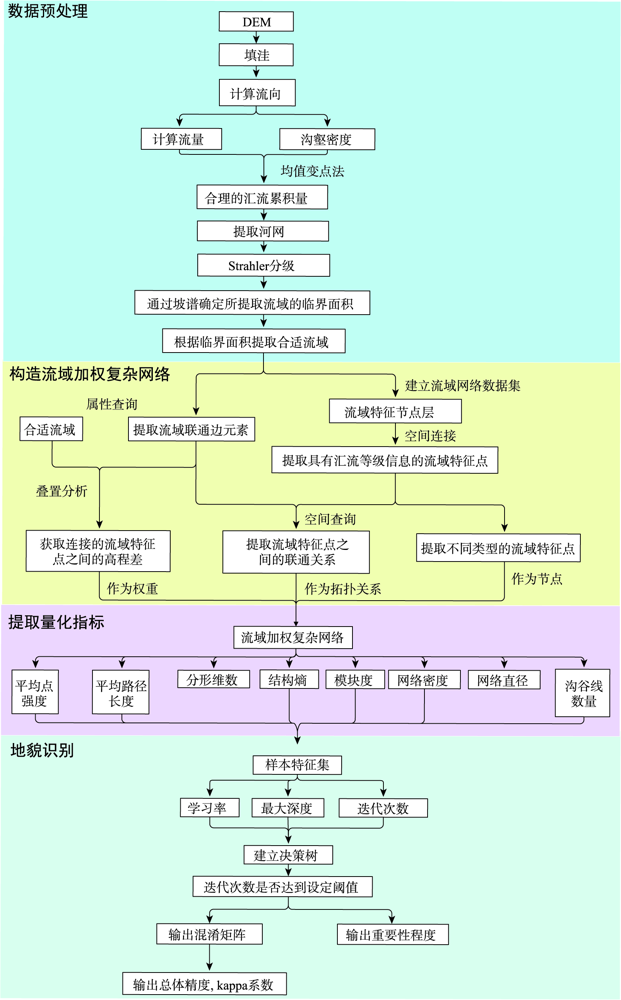
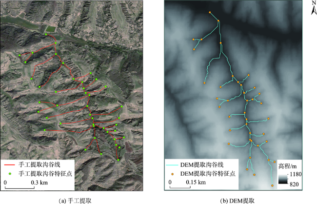
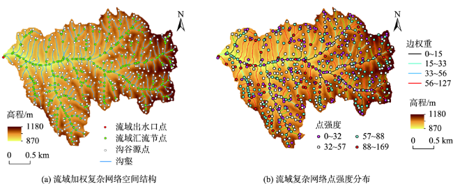
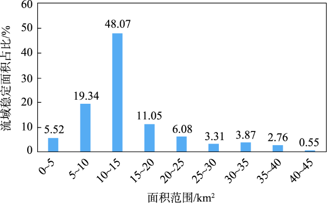
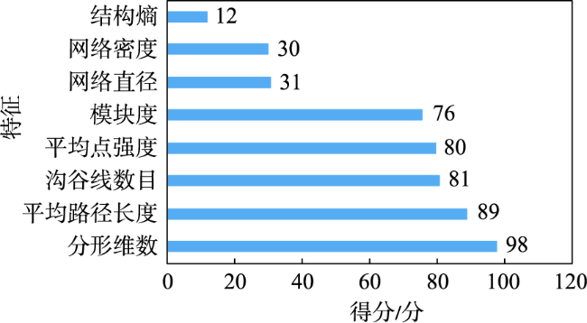
Landform recognition is of great significance to human construction, geological structure research, environmental governance and other related fields. Traditional recognition methodology is mainly based on pixel unit or object-oriented recgnition, which existed limitations. Landform recognition based on the watershed unit has become a new hotspot in this field because of its surface morphology integrity and clear geographical significance. However, the traditional methods of landform recognition based on terrain factors are often simple or repeatable in the geological description, which cannot be used to describe the spatial structure and quantify the topological relationship characteristics of the watershed unit. The slope spectrum method was used to solve the problem that it was difficult to determine the stable area of watershed unit, and 181 small watersheds were extracted through hydrological analysis. Based on the theory of complex network and geomorphology, the concept of watershed weighted complex network and 8 quantitative indexes were put forward to simulate and quantify the spatial structure of the watershed. Finally, XGBoost machine learning algorithm is adopted for landform recognition. XGBoost machine learning algorithm based on decision tree is used for landform recognition. The experiment shows a well performance on the landform recognition of the main landform types on the Loess Plateau, with the Kappa coefficient of 86.00% and the overall accuracy of 88.33%. Compared with the landforms having obvious morphological features, the complex network method considers the characteristics of spatial structure and topological features, resulting in higher recognition accuracy and kappa coefficient of 90%~100%. Compared with previous studies, the recognition results show high accuracy, which verifies that the method based on watershed weighted complex network is an effective method with high accuracy for landform recognition based on watershed.

Key words: landform recognition; watershed; digital terrain analysis; Loess Plateau; terrain feature; DEM
LIN Siwei , CHEN Nan , LIU Qiqi , HE Zhuowen . Geomorphological Automatic Recognition of Loess Plateau based on Complex Network of Small Watershed from DEM[J]. Journal of Geo-information Science, 2022 , 24(4) : 657 -672 . DOI: 10.12082/dqxxkx.2022.210449
表1 流域加权复杂网络定量指标和相应的计算方法Tab. 1 Quantitative indexes of watershed weighted complex network and their corresponding computing method |
| 指标分类 | 指标名称 | 公式 | 说明 | 公式编号 |
|---|---|---|---|---|
| 点及其 派生指标 | 点强度 | 是节点i的近邻集合; 为节点i和节点j的连边权重,即为节点i和节点j之间的高程差; 为网络邻接矩阵元素; 为节点i的点强度 | (4) | |
| 网络密度 | m为网络中实际拥有的连接数;n为网络节点总数 | (5) | ||
| 线及其 派生指标 | 平均路径长度 | | 为网络中包含的节点总数; 为节点i和j之间的距离;即2个节点最短路径的边数 | (6) |
| 沟谷线数目 | 通过对流域的沟谷进行统计得到 | |||
| 网络直径 | | 为2个节点i和j之间的距离 | (7) | |
| 网络及其 派生指标 | 结构熵 | 表示 个节点的重要度; 为网络节点的总数; 表示第 节点的度 | (8) | |
| 计盒维数 | 对于任意一个沟谷网络,采用边长为r的正方形盒子覆盖时,会出现其中一些盒子是包含图形的,而另一些盒子却是空的,若逐渐增大盒子的尺寸,则包含图形的盒子数目就会越来越少。对不同的盒子边长(r=1,2,3,4,…,M),求取覆盖沟谷网络所需的非空盒子数N(r)。在适当的范围内,对r选取一系列不同的值,以lnr为横坐标,lnN(r)为纵坐标,利用最小二乘法对其进行线性回归,对其斜率取负即为沟谷网络的计盒维数 | (9) | ||
| 模块度 | | 为网络的总边数; 是节点i的权重和; r表示节点i和j之间的边的权值; 为令a=b时δ=1,否则δ=0的函数; 是节点i的社区。当模块度值为0时,表示网络中没有集聚结构 | (10) |
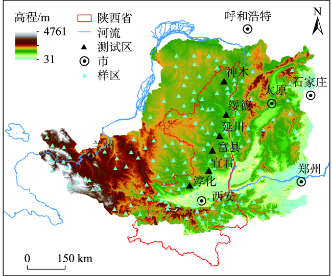
表2 黄土高原实验样区基础信息Tab. 2 Basic information of the study areas on Loess Plateau |
| 样区 | 地貌类型 | 平均坡度/° | 稳定面积/km2 |
|---|---|---|---|
| 神木 | 风沙-黄土过渡区 | 9 | 13.11 |
| 绥德 | 黄土峁状丘陵沟壑区 | 29 | 8.60 |
| 延川 | 黄土墚峁状丘陵沟壑区 | 31 | 10.13 |
| 富县 | 黄土墚峁状丘陵沟壑区 | 30 | 10.25 |
| 宜君 | 黄土残塬区 | 19 | 13.65 |
| 淳化 | 黄土塬区 | 12 | 34.28 |
表3 基于流域加权复杂网络的XGBoost混淆矩阵Tab. 3 Confusion matrix of XGBoost based on watershed weighted complex network |
| XGBoost识别结果 | |||||||||
|---|---|---|---|---|---|---|---|---|---|
| 黄土塬 | 黄土梁 | 黄土峁 | 石质山地 | 风积沙丘 | 河谷平原 | 精度/% | 召回率/% | F1值 | |
| 黄土塬 | 9 | 0 | 0 | 1 | 0 | 0 | 90 | 90 | 90 |
| 黄土梁 | 0 | 9 | 1 | 0 | 0 | 0 | 100 | 90 | 95 |
| 黄土峁 | 0 | 0 | 10 | 0 | 0 | 0 | 91 | 100 | 95.5 |
| 石质山地 | 0 | 0 | 0 | 9 | 0 | 1 | 82 | 90 | 86 |
| 风积沙丘 | 0 | 0 | 0 | 0 | 9 | 1 | 81 | 90 | 85.5 |
| 河谷平原 | 1 | 0 | 0 | 1 | 1 | 7 | 78 | 70 | 74 |
| 总体精度/% | 88.33 | ||||||||
| Kappa系数/% | 86.00 | ||||||||
表4 基于传统地形因子的XGBoost混淆矩阵Tab. 4 Confusion matrix of XGBoost based on traditional terrain indices |
| XGBoost识别结果 | |||||||||
|---|---|---|---|---|---|---|---|---|---|
| 黄土塬 | 黄土梁 | 黄土峁 | 石质山地 | 风积沙丘 | 河谷平原 | 精度/% | 召回率/% | F1值/% | |
| 黄土塬 | 8 | 0 | 0 | 0 | 1 | 1 | 73 | 80 | 76.5 |
| 黄土梁 | 0 | 8 | 1 | 1 | 0 | 0 | 80 | 80 | 80.0 |
| 黄土峁 | 1 | 2 | 7 | 0 | 0 | 0 | 88 | 70 | 79.0 |
| 石质山地 | 0 | 0 | 0 | 8 | 1 | 1 | 80 | 80 | 80.0 |
| 风沙丘陵 | 1 | 0 | 0 | 1 | 7 | 1 | 70 | 70 | 70.0 |
| 河谷平原 | 1 | 0 | 0 | 0 | 1 | 8 | 73 | 80 | 76.5 |
| 总体精度/% | 76.70 | ||||||||
| Kappa系数/% | 72.04 | ||||||||
| [1] |
王锡魁, 王德. 现代地貌学[M]. 长春: 吉林大学出版社, 2009.
[
|
| [2] |
|
| [3] |
|
| [4] |
|
| [5] |
曹伟超, 陶和平, 孔博, 等. 青藏高原地貌形态总体特征的GIS识别分析[J]. 水土保持通报, 2011,31(4):163-167,247.
[
|
| [6] |
|
| [7] |
刘双琳, 李发源, 蒋如乔, 等. 黄土地貌类型的坡谱自动识别分析[J]. 地球信息科学学报, 2015,17(10):1234-1242.
[
|
| [8] |
陈楹, 李安波, 姚蒙蒙, 等. 基于空间结构模式匹配的褶皱地貌类型自动识别[J]. 地球信息科学学报, 2016,18(11):1500-1512.
[
|
| [9] |
|
| [10] |
|
| [11] |
张福浩, 朱月月, 赵习枝, 等. 地理因子支持下的滑坡隐患点空间分布特征及识别研究[J]. 武汉大学学报·信息科学版), 2020,45(8):1233-1244.
[
|
| [12] |
曹伟超, 陶和平, 孔博, 等. 利用最佳地形特征空间进行地貌形态自动识别——以西南地区为例[J]. 武汉大学学报·信息科学版, 2011,36(11):1376-1380.
[
|
| [13] |
|
| [14] |
王乐, 周毅, 李阳. 面向子流域单元的典型黄土地貌分类研究[J]. 干旱区研究, 2019,36(6):1592-1598.
[
|
| [15] |
|
| [16] |
王彦文, 秦承志. 地貌形态类型的自动分类方法综述[J]. 地理与地理信息科学, 2017,33(4):16-21.
[
|
| [17] |
|
| [18] |
|
| [19] |
|
| [20] |
曹泽涛, 方子东, 姚瑾, 等. 基于随机森林的黄土地貌分类研究[J]. 地球信息科学学报, 2020,22(3):452-463.
[
|
| [21] |
| [22] |
|
| [23] |
|
| [24] |
|
| [25] |
|
| [26] |
|
| [27] |
|
| [28] |
|
| [29] |
|
| [30] |
武鹏飞, 宫辉力, 周德民. 基于复杂网络的官厅水库流域土地利用/覆被变化[J]. 地理学报, 2012,67(1):113-121.
[
|
| [31] |
田剑, 汤国安, 赵明伟. 基于复杂网络模型的黄土模拟流域坡面形态演化[J]. 农业工程学报, 2015,31(13):164-170.
[
|
| [32] |
裴燕如, 孙炎浩, 于强, 等. 黄河流域典型矿区生态空间网络优化——以鄂榆地区为例[J]. 煤炭学报, 2021,46(5):1541-1554.
[
|
| [33] |
吴念鲁, 徐丽丽, 苗海宾. 我国银行同业之间流动性风险传染研究——基于复杂网络理论分析视角[J]. 国际金融研究, 2017(7):34-43.
[
|
| [34] |
贺卓文, 陈楠. 复杂网络理论在黄土高原沟谷地貌特征研究中的应用[J]. 地球信息科学学报, 2021,23(7):1196-1207.
[
|
| [35] |
田剑, 汤国安, 赵明伟. 流域地形景观系统的复杂网络描述[J]. 地理与地理信息科学, 2014,30(4):22-26.
[
|
| [36] |
|
| [37] |
|
| [38] |
熊礼阳, 汤国安. 黄土高原沟谷地貌发育演化研究进展与展望[J]. 地球信息科学学报, 2020,22(4):816-826.
[
|
| [39] |
周毅. 基于DEM的黄土高原正负地形及空间分异研究[D]. 南京:南京师范大学, 2011.
[
|
| [40] |
|
| [41] |
|
| [42] |
|
| [43] |
赖晗, 芮小平, 梁汉东, 等. 基于均值变点分析的三峡库区河网提取研究[J]. 测绘科学, 2012,37(5):173-175.
[
|
| [44] |
|
| [45] |
张静静, 朱文博, 赵芳, 等. 山地平原过渡带地形起伏特征及其对景观格局的影响——以太行山淇河流域为例[J]. 中国科学:地球科学, 2018,48(4):476-486.
[
|
| [46] |
汪凯, 陈楠. 顾及空间特征的地形特征点提取方法[J]. 测绘科学, 2021,46(2):192-202.
[
|
| [47] |
李炫, 杨本勇, 范建容, 等. 基于流域单元的岷江上游泥石流危险性评价[J]. 水土保持研究, 2015,22(6):335-339.
[
|
| [48] |
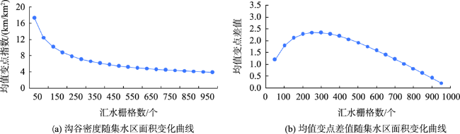
常直杨, 王建, 白世彪, 等. 均值变点分析法在最佳集水面积阈值确定中的应用[J]. 南京师大学报(自然科学版), 2014,37(1):147-150.
[
|
| [49] |
苟娇娇, 罗明良, 王飞. 影响黄土高原集水面积阈值的地形因子主成分分析[J]. 武汉大学学报·信息科学版, 2017,42(5):704-710.
[
|
| [50] |
王春, 汤国安, 李发源, 等. 基于DEM提取坡谱信息的不确定性[J]. 地球信息科学, 2008,10(4):539-544.
[
|
| [51] |
汤国安, 赵牡丹, 李天文, 等. DEM提取黄土高原地面坡度的不确定性[J]. 地理学报, 2003,58(6):824-830.
[
|
| [52] |
王春, 汤国安, 李发源, 等. 坡谱提取与应用的基本地域条件[J]. 地理科学, 2007,(4):587-592.
[
|
| [53] |
|
| [54] |
|
| [55] |
|
| [56] |
赵孜博, 杨勤科, 王春梅. 坡度统计分析的最小面积阈值研究[J]. 测绘科学, 2020,45(2):172-177,192.
[
|
| [57] |
|
| [58] |
|
| [59] |
王春, 汤国安, 李发源, 等. 基于DEM提取坡谱信息的不确定性[J]. 地球信息科学, 2008,10(4):539-544.
[
|
| [60] |
|
| [61] |
|
| [62] |
汪小帆, 李翔, 陈关荣. 复杂网络理论及其应用[M]. 北京: 清华大学出版社, 2006.
[
|
| [63] |
|
| [64] |
|
| [65] |
张岩, 李英冰, 郑翔, 等. 基于出租车数据的轨迹网络与流动模式研究[J]. 地理空间信息, 2021,19(7):1-6.
[
|
| [66] |
|
| [67] |
|
| [68] |
|
/
| 〈 |
|
〉 |