
Journal of Geo-information Science >
Water Information Extraction of Selenga River Basin in Mongolia based on Deep Neural Network
Received date: 2021-01-20
Request revised date: 2021-03-20
Online published: 2022-07-25
Supported by
National Natural Science Foundation of China(41971385)
Strategic Priority Research Program (Class A) of the Chinese Academy of Sciences(XDA2003020302)
Construction Project of the China Knowledge Center for Engineering Sciences and Technology(CKCEST-2021-2-18)
Copyright
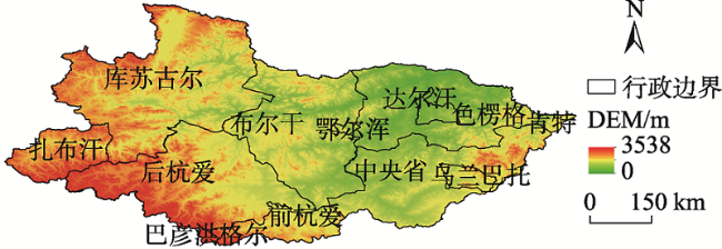
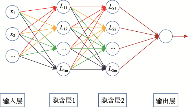
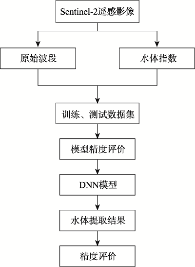
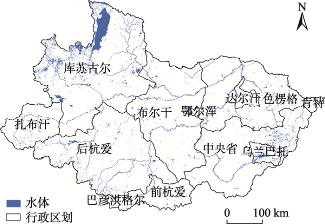
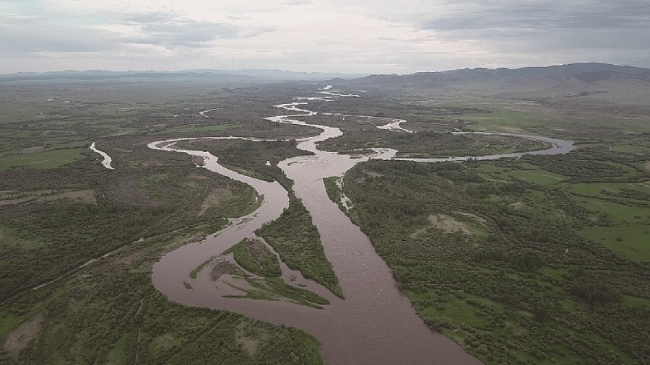
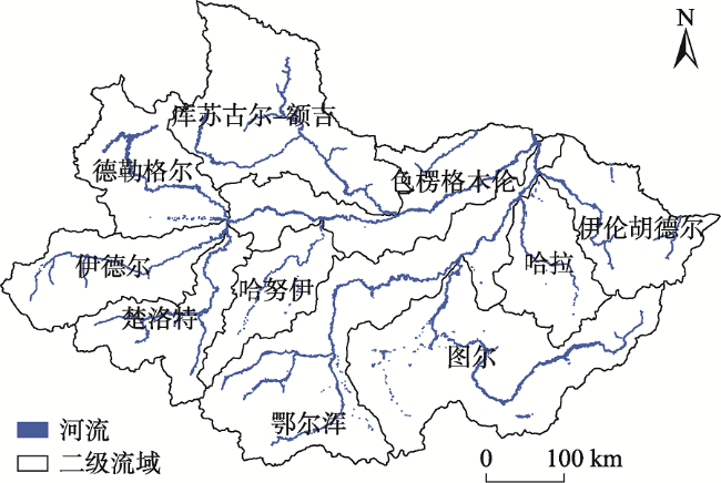
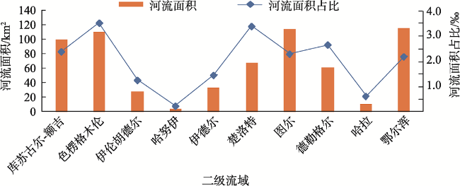
Arid and semi-arid climate zones of the Mongolian Plateau support multiple river systems that significantly impact the distribution of resources and ecological environments of the region. The Selenga River is the most important water resource on the Mongolian Plateau and the only river that enters the largest freshwater lake in the world——Lake Baikal in Russia. Thus, an accurate understanding of the hydrologic characteristics of the Selenga River Basin is critical in monitoring the ecology, environment, and water resources in Northeast Asia. Obtaining the plane morphology of curved rivers in the upper reaches of the plateau region is helpful to analyze the mathematical and physical mechanism of the evolution of curved rivers, which is of great significance to the study of river geomorphology. In this study, the Selenga River Basin in the Mongolia was taken as the study area. Based on the Google Earth Engine (GEE) cloud platform, Sentinel-2 multi-spectral satellite remote sensing images, Normalized Difference Water Index (NDWI), Modified Normalized Difference Water Index (MNDWI), and automated Water Extraction Index (AWEI) were used to construct a deep neural network model for the extraction of fine water body data in the Selenga River Basin. Three different types of water bodies, including lakes, main streams, and tributaries, were selected to compare the extraction results of deep neural network with the extraction results of support vector machines and Global Surface Water data. Global 30 m SRTM data were then used to generate a river system vector distribution map, identify river extraction target areas, and draw a 10 m spatial resolution river distribution map for the 2019 Selenga River Basin using output from the deep neural network model. Results indicate that, firstly, this method can accurately produce a water regime map for a large basin. The extraction results can reflect the spatial distribution of rivers in the Selenga River Basin in Mongolia, as well as reduce the drying-up and empty phenomenon of rivers. Secondly, the batch size of eight in the deep neural network model optimize data processing speed and accuracy while the four hidden layers in the neural network structure produce an accuracy evaluation index of 0.9666, which guarantees feature mining capabilities of models. Thirdly, after the verification of sample points, the overall accuracy reaches 97.65%, meeting actual application requirements. Thus, this research provides a method and data support for water body extraction for the Mongolian Plateau, which will play an important role in revealing long-term changes in river hydrological conditions, and impact related research on resources and environmental benefits.

YAO Jinyi , WANG Juanle , YAN Xinrong , WEI Haishuo , Altansukh Ochir , Davaadorj Davaasuren . Water Information Extraction of Selenga River Basin in Mongolia based on Deep Neural Network[J]. Journal of Geo-information Science, 2022 , 24(5) : 1009 -1017 . DOI: 10.12082/dqxxkx.2022.210031
表1 水体指数计算公式Tab. 1 Water index calculation |
| 水体指数 | 计算方法 | 编号 |
|---|---|---|
| NDWI | NDWI =( )/( ) | (1) |
| MNDWI | MNDWI =( )/( ) | (2) |
| AWEI | AWEInsh =4×( ) (0.25× +2.75× ) | (3) |
| AWEI | AWEIsh= +2.5× 1.5×( )-0.25× | (4) |
注: 为传感器绿波段; 为近红外波段; 为中红外波段; 为短波红外1; 为短波红外2。 |
表2 批量大小对DNN模型影响分析Tab. 2 Analysis of the influence of batch size on DNN model |
| 批量大小 | 训练集损失值 | 训练集准确率 | 测试集损失值 | 测试集准确率 |
|---|---|---|---|---|
| 4 | 0.1502 | 0.9508 | 0.1198 | 0.9632 |
| 8 | 0.1713 | 0.9489 | 0.1205 | 0.9666 |
| 16 | 0.1981 | 0.9407 | 0.1318 | 0.9615 |
| 32 | 0.2130 | 0.9381 | 0.1296 | 0.9582 |
| 64 | 0.2719 | 0.9047 | 0.2225 | 0.9415 |
表3 隐含层数对DNN模型影响分析Tab. 3 Analysis of the influence of hidden layers on DNN model |
| 层数 | 训练集损失值 | 训练集准确率 | 训练集损失值 | 测试集准确率 | |
|---|---|---|---|---|---|
| 1 | 0.2418 | 0.9198 | 0.2188 | 0.9197 | |
| 2 | 0.1958 | 0.9381 | 0.1382 | 0.9565 | |
| 3 | 0.2088 | 0.9438 | 0.1371 | 0.9615 | |
| 4 | 0.1713 | 0.9489 | 0.1205 | 0.9666 | |
| 5 | 0.2168 | 0.9426 | 0.1341 | 0.9632 | |
表4 水体信息提取结果细节对比Tab. 4 Detailed comparison of water body information extraction results |
| 水体类型 | 遥感影像 | DNN结果 | SVM结果 | JRC数据集 |
|---|---|---|---|---|
| 湖泊 | 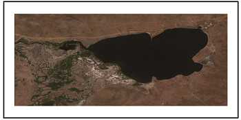 | 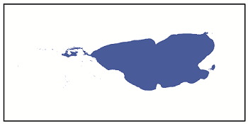 | 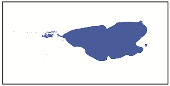 | 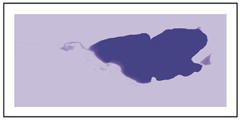 |
| 干流 | 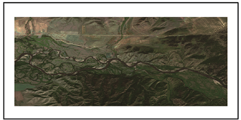 | 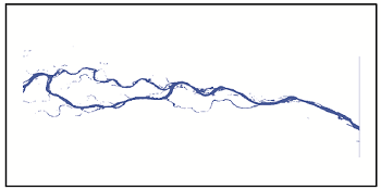 | 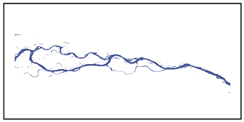 | 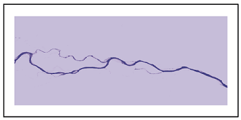 |
| 支流 | 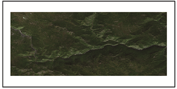 | 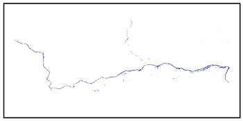 | 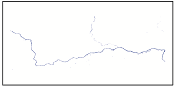 | 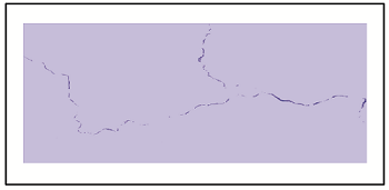 |
| [1] |
朱长明, 骆剑承, 沈占锋, 等. DEM辅助下的河道细小线性水体自适应迭代提取[J]. 测绘学报, 2013, 42(2):277-283.
[
|
| [2] |
孙娜, 高志强, 王晓晶, 等. 基于高分遥感影像的黄土高原地区水体高精度提取[J]. 国土资源遥感, 2017, 29(4):173-178.
[
|
| [3] |
肖茜, 杨昆, 洪亮. 基于多源数据的云贵高原湖泊水体提取方法对比研究[J]. 云南师范大学学报(自然科学版), 2018, 38(2):73-78.
[
|
| [4] |
张帅旗, 周秉荣, 史飞飞, 等. 基于高分一号卫星遥感数据的青藏高原高寒湿地信息提取方法研究——以玛多县为例[J]. 高原气象, 2020, 39(6):1309-1317.
[
|
| [5] |
|
| [6] |
周岩, 董金玮. 陆表水体遥感监测研究进展[J]. 地球信息科学学报, 2019, 21(11):1768-1778.
[
|
| [7] |
陈前, 郑利娟, 李小娟, 等. 基于深度学习的高分遥感影像水体提取模型研究[J]. 地理与地理信息科学, 2019, 35(4):43-49.
[
|
| [8] |
何海清, 杜敬, 陈婷, 等. 结合水体指数与卷积神经网络的遥感水体提取[J]. 遥感信息, 2017, 32(5):82-86.
[
|
| [9] |
|
| [10] |
|
| [11] |
|
| [12] |
郝斌飞, 韩旭军, 马明国, 等. Google Earth Engine在地球科学与环境科学中的应用研究进展[J]. 遥感技术与应用, 2018, 33(4):600-611.
[
|
| [13] |
|
| [14] |
贾文翰, 白建荣, 杨利荣. 河流湖泊湿地边界定位中遥感影像时相选择方法[J]. 测绘与空间地理信息, 2018, 41(1):46-48,54.
[
|
| [15] |
|
| [16] |
|
| [17] |
|
| [18] |
徐涵秋. 利用改进的归一化差异水体指数(MNDWI)提取水体信息的研究[J]. 遥感学报, 2005, 9(5):589-595.
[
|
| [19] |
|
| [20] |
冈萨雷斯, 伍兹. 数字图像处理(第三版)[M]. 北京: 电子工业出版社, 2017.
[
|
| [21] |
|
| [22] |
|
| [23] |
|
| [24] |
田富有, 吴炳方, 曾红伟, 等. 基于多层神经网络与Sentinel-2数据的大豆种植区识别方法[J]. 地球信息科学学报, 2019, 21(6):918-927.
[
|
/
| 〈 |
|
〉 |