
Journal of Geo-information Science >
Landmark Extraction Method and Personalized Wayfinding Application for We-Map
Received date: 2021-07-14
Request revised date: 2021-09-09
Online published: 2022-07-25
Supported by
2021 Central-Guided Local Science and Technology Development Fund of Gansu Province
National Natural Science Foundation of China(41930101)
Gansu Province Department of Education: “Innovation Star” Project of Excellent Postgraduates(2021CXZX-590)
Copyright
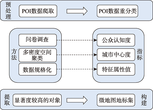
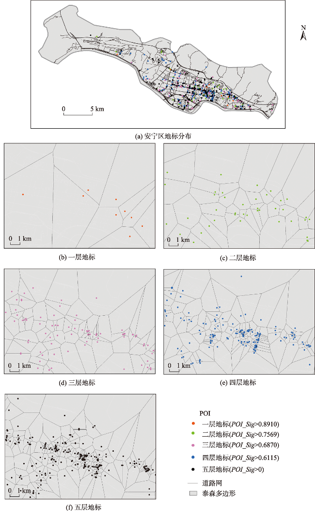
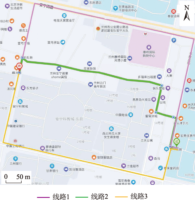
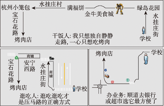
Landmarks play an important role in spatial information transmission, especially for wayfinding navigation. Numerous studies have shown that the inclusion of landmarks in route tasks can effectively reduce steering errors. How to incorporate landmarks into navigation systems and break the barrier of using distance information as the indicator to guide users in wayfinding is currently a difficult problem to solve. And we-map provides a platform for users to produce and disseminate map content. Because we-map does not distinguish between mapmakers and map users, it lowers the threshold for mapping and enables users to have self-make maps. In the process of route mapping, we-map platform can provide a collection of landmarks for users to choose from and use them to complete their wayfinding, enabling the solution to the challenge of incorporating landmarks into navigation systems. In order to extract we-map landmarks accorded with people's spatial cognition, the method of extracting landmarks by user-generated content is proposed. First, there are three indicators (public awareness, city centrality, and individual characteristic value) that are calculated separately, and each of them is obtained by the entropy value method. Then, landmarks are extracted in a hierarchical manner in term of the difference in the significance of landmarks to establish a set of landmarks for serving the users of the we-map. Last, the user-generated landmarks are collected during the process of publishing, sharing, and disseminating the we-map to enrich the landmark library, aiming at realizing secondary dissemination about the extraction of landmarks from user-generated contents. The experiment selects POI data of An Ning District in Lanzhou City to calculate landmark salience, selects landmarks at different levels according to different scales, designs tasks for participants to describe routes and complete connections between landmarks, collects usage landmarks, forms user-generated content to disseminate landmark data, and draws personalized routes that meet different user needs. This study simulates the process of route-finding cartography using landmarks by we-map users to pave the ground for personalized navigation on the we-map platform. The experimental results show that the content generated by using users' shared service data effectively solves the problem of acquiring and timely updating landmark candidate sets, expresses the user's cognitive expressiveness to the greatest extent, and reduces the burden of wayfinding for pedestrians walking out. This study is applied to daily wayfinding, where we-map users participate in constructing and sharing service data, forming spontaneous dissemination of user-generated content, timely update, and dissemination of landmark data, providing reference for rapid we-map drawing, and improving wayfinding efficiency.
HE Yang , YAN Haowen , WANG Zhuo , WANG Xiaolong . Landmark Extraction Method and Personalized Wayfinding Application for We-Map[J]. Journal of Geo-information Science, 2022 , 24(5) : 827 -836 . DOI: 10.12082/dqxxkx.2022.210376
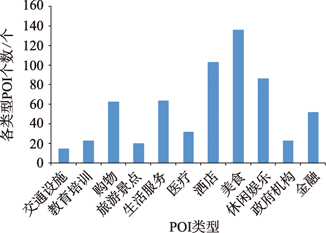
表1 各类POI公众认知度Tab. 1 Public awareness of each type of POI |
| 类型 | 均值 | 标准差 | 公众认知度 |
|---|---|---|---|
| 交通设施 | 4.6979 | 0.5779 | 1.0000 |
| 教育培训 | 4.3959 | 0.7877 | 0.8657 |
| 购物 | 4.0117 | 0.9316 | 0.6949 |
| 旅游景点 | 3.6745 | 1.0651 | 0.5450 |
| 生活服务 | 3.5191 | 0.8684 | 0.4759 |
| 医疗 | 3.4340 | 1.1200 | 0.4381 |
| 酒店 | 3.4194 | 1.0899 | 0.4316 |
| 美食 | 3.2522 | 1.0048 | 0.3572 |
| 休闲娱乐 | 3.0411 | 1.2150 | 0.2634 |
| 政府机构 | 2.9150 | 1.1392 | 0.2073 |
| 金融 | 2.7947 | 1.2344 | 0.1538 |
| 房地产 | 2.4487 | 1.2842 | 0.0000 |
表2 熵值法计算权重结果汇总Tab. 2 Summary of the results of calculating weights by the entropy value method |
| 项 | 信息熵值 | 信息效用值 | 权重系数/% |
|---|---|---|---|
| SSN_特征属性值 | 0.9923 | 0.0077 | 26.91 |
| SSN_城市中心度 | 0.9930 | 0.0070 | 24.44 |
| SSN_公众认知度 | 0.9861 | 0.0139 | 48.65 |
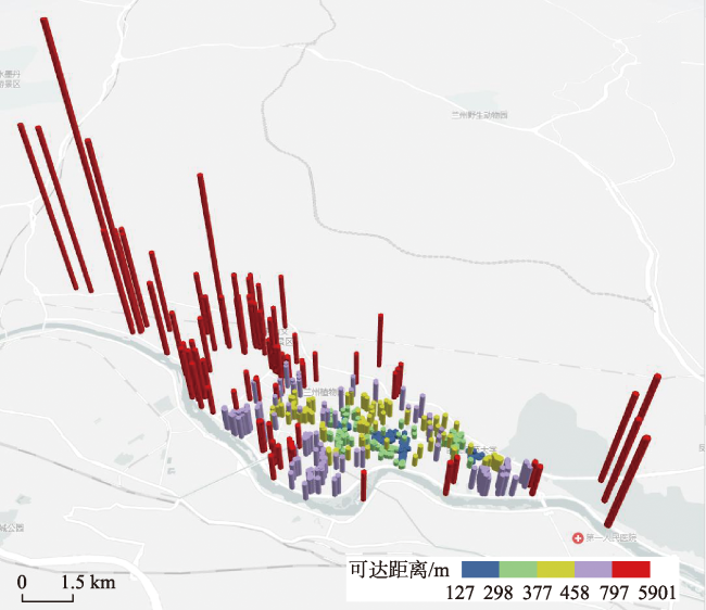
表3 兰州市安宁区部分POI显著度计算结果Tab. 3 Calculation results of the significance of some POIs in Anning District, Lanzhou City |
| 序号 | 名称 | 类别 | 特征等级 | 特征属性值 | 可达距离/m | 聚类等级 | 公众认知度 | 城市中心度 | 地标显著度 |
|---|---|---|---|---|---|---|---|---|---|
| 1 | 西北师范大学-第二附属中学 | 教育培训 | 5 | 1.0 | 308.0 | 4 | 0.8657 | 1.0 | 0.9342 |
| 2 | 星星充电站 | 交通设施 | 5 | 0.8 | 783.7 | 3 | 1.0000 | 0.8 | 0.9150 |
| 3 | 兰州交通大学 | 教育培训 | 5 | 0.9 | 411.4 | 4 | 0.8657 | 0.9 | 0.8917 |
| 4 | 怡美佳超市 | 购物 | 5 | 1.0 | 149.9 | 5 | 0.6949 | 1.0 | 0.8505 |
| 5 | 古法馆 | 旅游景点 | 5 | 1.0 | 842.3 | 3 | 0.5450 | 1.0 | 0.7771 |
| 6 | 漫客洗衣 | 生活服务 | 5 | 1.0 | 218.6 | 5 | 0.4759 | 1.0 | 0.7432 |
| 7 | 康怡齿科中心 | 医疗 | 5 | 1.0 | 583.1 | 3 | 0.4381 | 1.0 | 0.7247 |
| 8 | 兰州远方家庭公寓 | 酒店 | 5 | 1.0 | 308.0 | 4 | 0.4316 | 1.0 | 0.7215 |
| 9 | 灸草堂艾灸推拿调理馆 | 休闲娱乐 | 5 | 1.0 | 143.7 | 5 | 0.2634 | 1.0 | 0.6391 |
| 10 | 桃海小吃一条街 | 美食 | 5 | 1.0 | 155.4 | 5 | 0.3572 | 1.0 | 0.6850 |
| 11 | 一口香牛肉面 | 美食 | 5 | 1.0 | 391.3 | 4 | 0.3572 | 1.0 | 0.6850 |
| 12 | 中国农业银行 | 金融 | 5 | 0.8 | 695.0 | 3 | 0.1538 | 0.8 | 0.5004 |
表4 路线任务描述时最常用的地标Tab. 4 Most common landmarks used in route task description |
| 人数/人 | 地标 | 类型 | 是否在决策点处 | 层级 |
|---|---|---|---|---|
| 10 | 银行 | 金融 | 否 | 5 |
| 14 | 康桥国际 | 购物 | 是 | 3 |
| 12 | 旅馆 | 酒店 | 否 | 4 |
| 2 | 小米之家 | 生活服务 | 否 | 5 |
| 10 | 消防队 | 政府机构 | 是 | 1 |
| 5 | 肯德基 | 美食 | 否 | 5 |
| 13 | 斑马线 | 交通设施 | 是 | 0 |
| 8 | 小笼包 | 美食 | 否 | 4 |
| 12 | 红绿灯 | 交通设施 | 是 | 0 |
| 10 | 大黄蜂 | 标志性地物 | 否 | 0 |
| 7 | 快递驿站 | 生活服务 | 否 | 4 |
| 12 | 黑牛 | 标志性地物 | 是 | 0 |
| 14 | 兰州交通大学 | 教育培训 | 是 | 1 |
| [1] |
|
| [2] |
|
| [3] |
柳春生, 任福, 杜清运, 等. 基于社交网络数据的地标显著度模型构建与应用[J]. 地理信息世界, 2019, 26(1):127-131,138.
[
|
| [4] |
陈玥璐, 武刚, 陈飞翔. 基于地标的行人导航路径引导方法[J]. 地理与地理信息科学, 2015, 31(1):17-22.
[
|
| [5] |
|
| [6] |
|
| [7] |
|
| [8] |
|
| [9] |
|
| [10] |
|
| [11] |
|
| [12] |
|
| [13] |
智梅霞, 贾奋励, 田江鹏, 等. 显著度模型的地标提取方法综述[J]. 测绘科学, 2017, 42(4):48-54,67.
[
|
| [14] |
|
| [15] |
|
| [16] |
|
| [17] |
|
| [18] |
|
| [19] |
王明. 基于位置签到数据的城市地标提取与商圏挖掘研究[D]. 武汉:武汉大学, 2015.
[
|
| [20] |
李佳田, 吴华静, 高鹏, 等. 一种复合Voronoi几何特征的地标提取新方法[J]. 武汉大学学报·信息科学版, 2020, 45(9):1448-1454.
[
|
| [21] |
|
| [22] |
闫浩文, 张黎明, 杜萍, 等. 自媒体时代的地图:微地图[J]. 测绘科学技术学报, 2016, 33(5):520-523.
[
|
| [23] |
迟璐, 宋伟东, 朱霞. 城市POI的空间数据分析与可视化表达[J]. 测绘与空间地理信息, 2020, 43(2):109-113,117.
[
|
| [24] |
康雨豪, 王玥瑶, 夏竹君, 等. 利用POI数据的武汉城市功能区划分与识别[J]. 测绘地理信息, 2018, 43(1):81-85.
[
|
| [25] |
|
| [26] |
|
| [27] |
杨小兵. 聚类分析中若干关键技术的研究[D]. 杭州:浙江大学, 2005.
[
|
| [28] |
赵卫锋, 李清泉, 李必军. 利用城市POI数据提取分层地标[J]. 遥感学报, 2011, 15(5):973-988.
[
|
| [29] |
|
| [30] |
陈香, 李晓明, 詹然, 等. 从城市兴趣点中提取多层次地标方法探究[J]. 测绘与空间地理信息, 2015, 38(10):129-132,136.
[
|
/
| 〈 |
|
〉 |
