
Journal of Geo-information Science >
Generation Methods of the Web Electronic Map for Data Model of Multi-granularity Spatio-temporal Object
Received date: 2021-10-03
Revised date: 2022-03-07
Online published: 2022-09-25
Supported by
National Key Research and Development Program of China(2021YFB3900900)
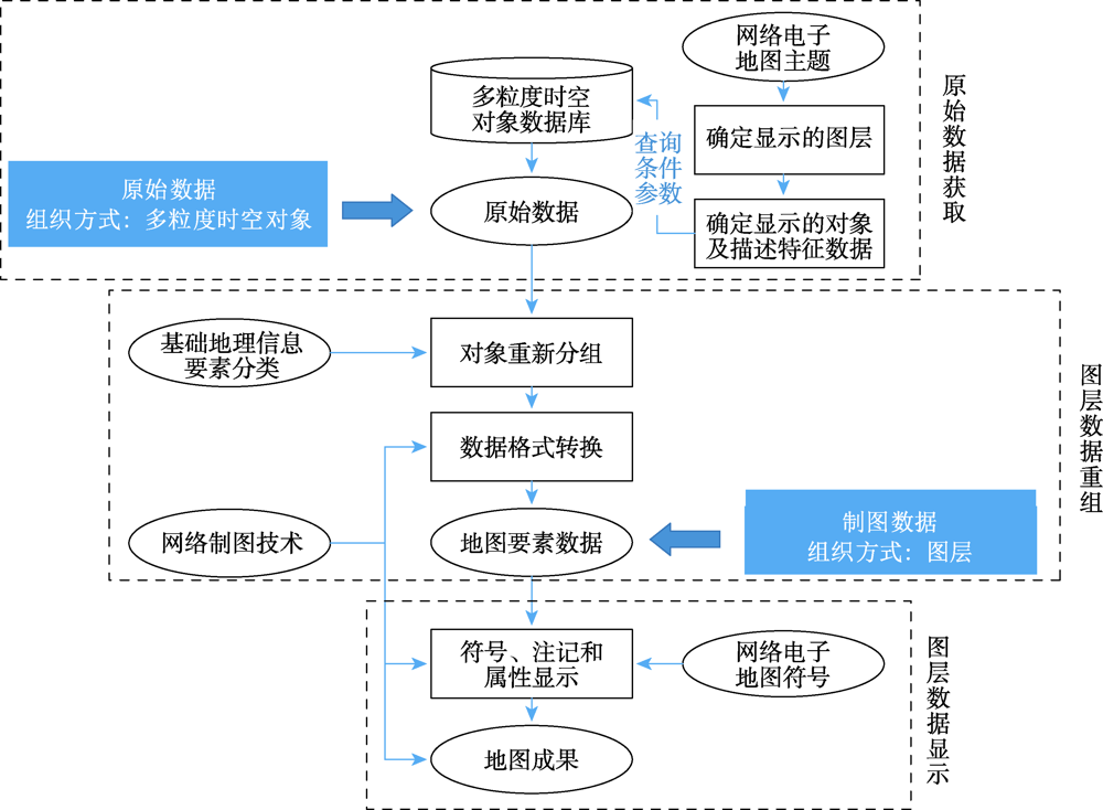
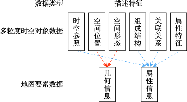
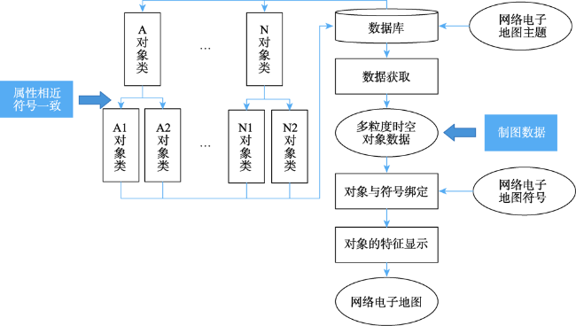
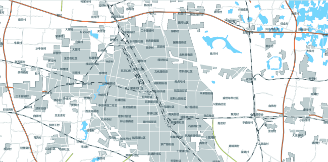
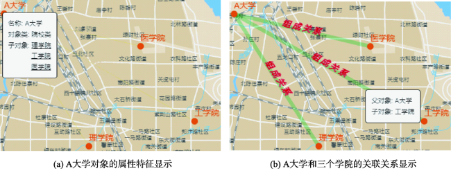
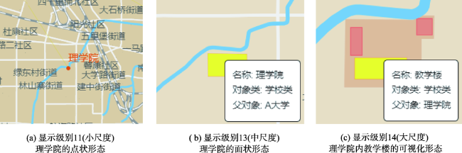
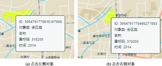
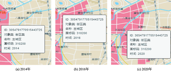
Traditional web electronic map is a composition of several layers containing geometry elements, which rely on an object-oriented model. However, this model is too abstract to map a more complex world. So the maps based on this model have limitations in expressing the characteristics of dynamic changes and correlation of geographical entities. Domain experts have proposed the data model of Multi-Granularity Spatio-Temporal Object (MGSTO) in recent years, aiming to solve problems of mapping the real world to the “thing space” which is full of “objects”. This inspires new visualizations on the spatio-temporal phenomenon, at the same time, changes the way of map making. Visualizations or maps based on this data model have access to data that are more reliable. The problem is that there is no such map making technique or tool that can deal with it. Therefore, we propose two map marking methods that can make full use of this data model. Firstly, we think it is necessary to bridge existing web cartography platforms and the MGSTO database, so we propose the layer-reconstruction method. In this way, all the online mapping platforms have the ability to understand the data model of MGSTO and make maps depending on it. This method looks like a "middleware" of online mapping tools. Secondly, we propose a method that binds MGSTO onto HTML DOMs, for example, Scalable Vector Graphic(SVG) objects. The MGSTO data is visualized directly into graphic elements (or symbols) and its changes and transforms can be easily reflected onto symbols. The advantage of this method is that updating maps is synchronized with database updates. Maps made by this method can be linked to the real world due to the data model of MGSTO, which has the ability to manage multi-scale features. More complex information such as relation and composition can be easily extracted from the data model of MGSTO, which can be further mapped as thematic maps. Multi-granularity features can be shown by this method. Each of these two map making methods has distinct characteristics. The first method provide mature and stable style of geographic data visualization, and it can be published online easily because it use online infrastructure provided by online mapping platforms. The second method provide map makers more freedom in map design. Users can perfect the data model of MGSTO targeting certain map making objectives. However, more algorithms such as generalization need to be developed for the data model of MGSTO. In addition, this research carries out two experiments using the same dataset to verify our methods, which demonstrates the feasibility our proposed methods.
GUO Wei , GU Yuhang , JIANG Nan . Generation Methods of the Web Electronic Map for Data Model of Multi-granularity Spatio-temporal Object[J]. Journal of Geo-information Science, 2022 , 24(7) : 1264 -1274 . DOI: 10.12082/dqxxkx.2022.210603
表1 实验1的地图显示风格Tab. 1 Customised style of maps in experiment-1 |
| 图层 | 渲染类型 | 渲染属性 | 渲染参数 | 示例 |
|---|---|---|---|---|
| 面状:居民地、水库和河流 | fill | paint | 颜色、边线颜色等 |   |
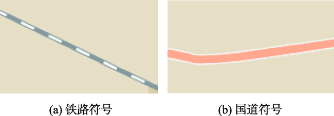
| 线状:铁路、城市道路、乡道、 县道、省道和国道 | line | layout、paint | 颜色、宽度、线条末端线帽样式等 |    |
| 点状居民地 | circle、symbol | layout、paint | 颜色、圆点半径等 |  |
| 注记 | symbol | layout、paint | 内容、颜色、字体等 |  |
表2 多粒度时空对象子类划分Tab. 2 Division of object subclasses |
| 对象大类 | 对象子类 | |
|---|---|---|
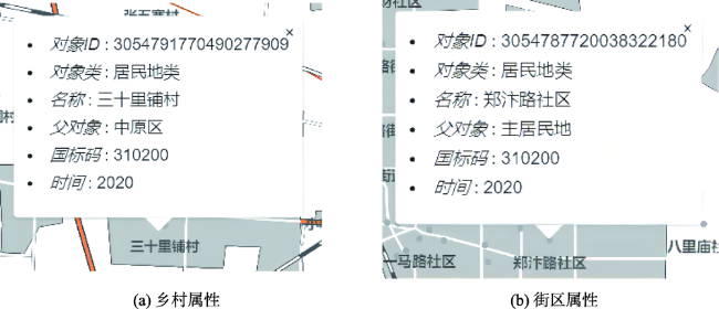
| 居民地类 | 街区类、村庄类、地方政府类、院校类 | |
| 交通类 | 公路类 | 城市道路类、乡道类、县道类、省道类、国道类 |
| 铁路类 | 标准轨距铁路类 | |
| 水系类 | 水库类、河流类、湖泊类 | |
| [1] |
|
| [2] |
|
| [3] |
高俊. 地图学四面体——数字化时代地图学的诠释[J]. 测绘学报, 2004, 33(1):6-11.
[
|
| [4] |
|
| [5] |
|
| [6] |
舒红, 陈军, 杜道生, 等. 面向对象的时空数据模型[J]. 武汉测绘科技大学学报, 1997, 22(3):229-233.
[
|
| [7] |
|
| [8] |
|
| [9] |
|
| [10] |
王家耀, 武芳, 闫浩文. 大变化时代的地图学[J/OL]. 测绘学报, 2022-02-18.
[
|
| [11] |
华一新, 周成虎. 面向全空间信息系统的多粒度时空对象数据模型描述框架[J]. 地球信息科学学报, 2017, 19(9):1142-1149.
[
|
| [12] |
陈万鹏. 基于矢量地图数据的多粒度时空对象生成技术[D]. 郑州: 战略支援部队信息工程大学, 2018.
[
|
| [13] |
张政. 时空对象关联关系生成、管理与可视化关键技术研究[D]. 郑州: 战略支援部队信息工程大学, 2020.
[
|
| [14] |
曹一冰, 张江水, 华一新, 等. 全空间时空对象可视化工具的设计与实现[J]. 测绘科学技术学报, 2021, 38(2):173-180.
[
|
| [15] |
华一新, 张江水, 曹一冰. 基于时空域的全空间数字世界时空对象组织与管理研究[J]. 地球信息科学学报, 2021, 23(1):76-83.
[
|
| [16] |
国家质量监督检验检疫总局; 中国国家标准化管理委员会. 基础地理信息要素分类与代码: GB/T 13923—2006[S]. 北京: 中国标准出版社, 2006.
[ Standardization Administration of the People's Republic of China. Specifications for feature classification and codes of fundamental geographic information: GB/T 13923—2006[S]. Beijing: Standards Press of China, 2006. ]
|
| [17] |
|
| [18] |
李锐, 石佳豪, 董广胜, 等. 多粒度时空对象组成结构表达研究[J]. 地球信息科学学报, 2021, 23(1):113-123.
[
|
| [19] |
国家基础地理信息中心. 全国地理信息资源目录服务系统. https://www.webmap.cn/main.do?method=index.
[ National Geomatics Center of China. National Catalogue Service For Geographic Information. https://www.webmap.cn/main.do?method=index.
|
| [20] |
郭玥晗. 校史地图信息的时空对象建模与可视化表达技术研究[D]. 郑州: 战略支援部队信息工程大学, 2020.
[
|
/
| 〈 |
|
〉 |
