Spatio-temporal Moran Scatter Plot and its Application in Identifying Drought Spatio-temporal Aggregation Areas in China

  • WANG Zheng , 1, 2, 3 ,
  • CHENG Changxiu , 1, 2, 3, * ,
  • LI Chang 4
Expand
  • 1. State Key Laboratory of Earth Surface Processes and Resource Ecology, Beijing Normal University, Beijing 100875, China
  • 2. Key Laboratory of Environmental Change and Natural Disaster, Beijing Normal University, Beijing 100875, China
  • 3. Faculty of Geographical Science, Beijing Normal University, Beijing 100875, China
  • 4. Department of Geography, University of Wisconsin-Madison, Madison 53706-1404, United States
* CHENG Changxiu, E-mail:

Received date: 2021-10-15

  Revised date: 2021-12-27

  Online published: 2022-09-25

Supported by

National Key Research and Development Program in China(2019YFA0606901)

Abstract

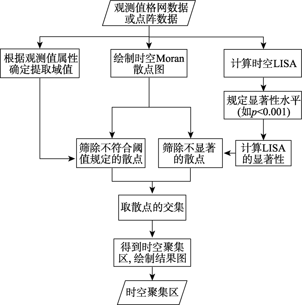
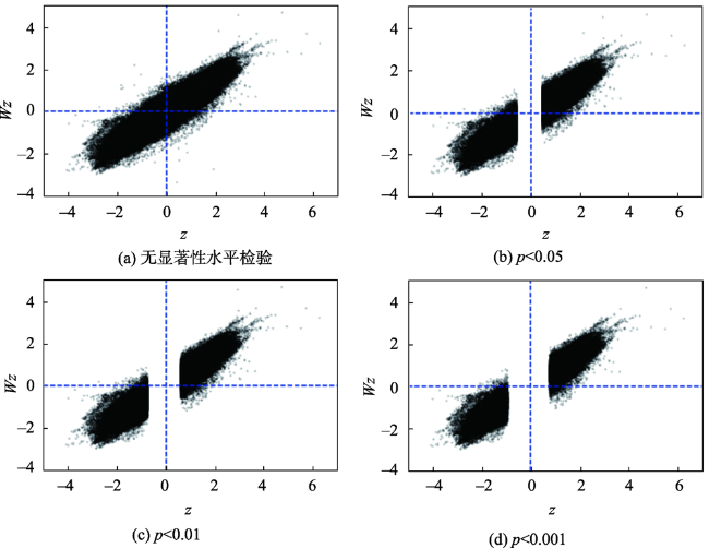
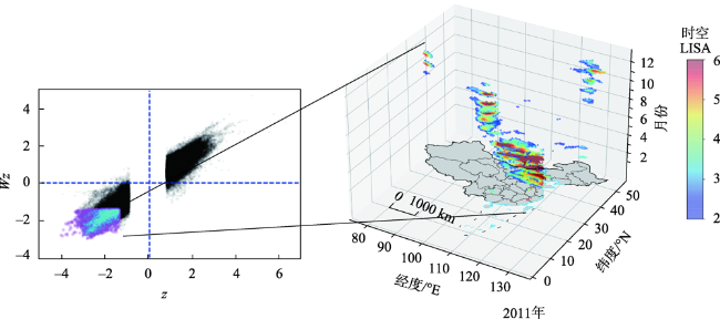
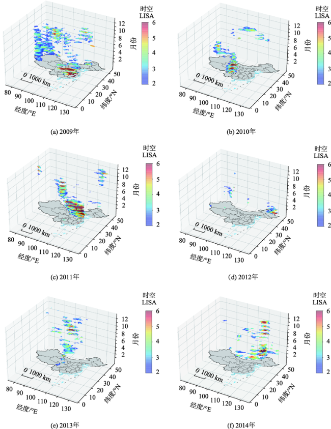
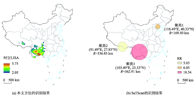
Drought, as one of the most difficult natural disasters to identify, causes the most serious economic losses in the entire natural disaster system. Drought in spatio-temporal aggregation areas deserves more attention than its changes and patterns because it usually causes greater damages. SaTScan provides a method for identifying spatio-temporal aggregation areas of disaster. However, there are also some defects, such as difficulty in parameter setting and inefficiency in boundary identification. For instance, the maximum scanning window in SaTScan needs to take many attempts to get a fine result. Moran scatter plot provides a method for the identification of spatio aggregation areas, which could solve problems that SaTScan faces above, but it could only identify aggregation areas in space. In this study, we proposed a method named Spatio-temporal Moran Scatter Plot based on Moran scatter plot and Local Indicators of Association (LISA), which could select scatters according to the threshold of concerned phenomenon and the LISA confidence level required by the researcher. This method plotted scatters in spatio-temporal coordinate system to get the spatio-temporal aggregation areas. This study took droughts in China from 2009—2014 as an example to identify the spatio-temporal aggregation areas, the results showed that:(1) Spatio-temporal drought aggregation areas identified by the proposed method were almost consistent with the truth, which demonstrated the effectiveness of the method. Besides, compared with the spatio-temporal scanning method, the method proposed in this study was not only easier in parameters setting but also clearer and more accurate in boundary identification; (2) The large-scale, strong drought spatio-temporal aggregation areas occurred in 2009 and 2011. In 2009, the main aggregation areas concentrated in Shanxi, Shaanxi, Beijing-Tianjin-Hebei, eastern Tibet, northeastern Inner Mongolia, Liaoning, Jilin, and Yunnan-Guizhou-Sichuan area; in 2011, the main aggregation areas concentrated in Huanghuai area, the middle and lower reaches of the Yangtze River, and Yunnan-Guizhou-Sichuan area. The local-scale, strong drought spatio-temporal aggregation areas occurred in 2010 and 2014. In 2010, the main aggregation areas concentrated in Yunnan-Guizhou-Sichuan area; in 2014, the main aggregation areas concentrated in Eastern Inner Mongolia, Liaoning, and other areas in Northeast China. The slight drought spatio-temporal aggregation areas occurred in 2012 and 2013. In 2013, some mild drought clusters occurred in western Inner Mongolia, southern Gansu, Ningxia, southern Shaanxi, and northern Henan. In general, the spatio-temporal drought aggregation areas concentrated mainly in Yunnan-Guizhou-Sichuan, Northeast China, Huanghuai Region, and the middle and lower reaches of the Yangtze River.

Cite this article

WANG Zheng , CHENG Changxiu , LI Chang . Spatio-temporal Moran Scatter Plot and its Application in Identifying Drought Spatio-temporal Aggregation Areas in China[J]. Journal of Geo-information Science, 2022 , 24(7) : 1301 -1311 . DOI: 10.12082/dqxxkx.2022.210633

1 引言

中国是世界上受旱灾影响最严重的国家之一,据统计,气象灾害损失占中国全部自然灾害损失的61%,其中旱灾占比又高达其中的55%[1]。基于气象观测或再分析等数据开展地理现象(干旱)时空格局与演变研究是地理领域的热点之一[2-3]。过去几十年,干旱时空格局及演变研究取得了显著成果。高燕俐等利用不同时间尺度的标准化降水指数(Standardized Precipitation Index, SPI)和标准化降水蒸散指数(Standardized Precipitation Evaporation Index, SPEI)对广西壮族自治区干旱空间格局进行识别,并利用折线图对时间趋势进行分析[4],Gao等[5]利用SPEI对黄土高原干旱时空趋势进行识别,采用空间快照叠加时间趋势的方式表示其时空演变,Kai等[6]利用3个月尺度的SPI和SPEI对1961—2012年的干旱事件进行时空识别,并对其干旱轨迹进行研究。
上述研究多采用时空快照识别干旱时空格局,即先建立若干时间段内干旱格局的空间快照、再人工解译空间格局与时间过程;然而,面对长时间序列的数据,该方法通常需要做时段的划分,如何划分时段时是需要回答的问题,此外某时段综合的结果难以还原该时段内精细的时间过程、也难以科学刻画精细的空间边界。如何精细、准确地给出时空聚集区边界并辅以相应的不确定性描述,是时空统计学的重要科学问题之一,即时空聚集区识别问题。目前,时空统计学中较为成熟的方法是时空扫描统计法,即利用不同大小的圆柱体在时空数据中进行扫描,找出显著聚集的若干圆柱作为时空聚集区。该方法已被Kulldorff M等[7]在SaTScan软件中实现,并广泛应用于时空聚集区的识别中[8]。文献[9]—[11]分别对杭州市流感病例、抚州市肺结核、温州市的新型冠状病毒肺炎的时空聚集性进行识别。文献[12]利用时空扫描模型和局部空间自相关模型对中国区域的极端降水时空聚集区进行识别,该模型原理与SaTScan类似。
尽管时空扫描方法已得到广泛应用,但是该方法仍然存在2个问题:① 该方法扫描出的时空聚集区通常为圆柱体,但在时空聚集区不规则的情况下SaTScan难以给出精确的边界;② 最大扫描窗口等参数的设定往往需要多次尝试,才能取得较好的效果。当然,不少学者也尝试对该方法进行改进;如张婷等[13]利用SaTScan结合Moran散点图识别了2013年7月极端高温的时空聚集区;万幼等[14]提出一种不规则形状的时空异常聚类模式挖掘方法stAntScan,可以较为准确地获取聚类区形状。虽然这些方法可以获得相对精准的时空聚集区边界,但依然存在原理、参数复杂等问题。
Moran散点图作为常用的空间聚集区识别方法,具有计算简单、范围精确的优点;但它只能进行空间聚集区的识别[15-17],无法直接应用于时空聚集区。论文通过对Moran散点图进行时空扩展,得到时空Moran散点图,而后辅以时空扩展后的局部空间关联指标(Local Indicators Spatial Association, LISA)进行显著性检验,创新地提出一种时空聚集区识别方法,并以2009—2014年中国干旱时空聚集区的识别为例,对该方法进行了验证。

2 数据来源与研究方法

2.1 数据来源及处理

2.1.1 NSPEI数据及其处理

考虑到气象数据的非平稳性[18-20],论文选用温庆志等[21]计算的3个月尺度的非平稳标准化降水蒸散指数(Non-stationary Standardized Precipitation Evaporation Index, NSPEI)进行干旱的时空聚集性识别。温志庆等[21]已证实NSPEI对中国区域的干旱指示作用优于SPEI;同时,已有研究表明:代表季节尺度的3个月的干旱指数在中国各区域的适用性较好[22]
由于温庆志等[23]仅给出了全国2474个站点的NSPEI,为了将点数据预测到中国全空间域上,论文采用协同克里金法进行插值。NSPEI存在显著的空间异质性,普通克里金法难以准确预测;因此论文引入引发异质性的协变量,采用协同克里金法提高预测精度[24-25]。考虑到NSPEI与土壤湿度的相关性[21],协变量选用土壤湿度,该数据来源于欧洲中期天气预报中心发布的ERA5数据。通过协同克里金插值,得到了2009—2014年全国的NSPEI,插值结果的标准均方根误差在0.9~1.1之间,而标准均方根误差越接近1说明插值结果与真实值越接近[25-26]。然后,对插值结果格网化,得到2009—2014年0.5°×0.5°逐月尺度的全国NSPEI栅格数据集,为后续干旱时空聚集区的提取奠定数据基础。

2.1.2 验证数据

论文收集整理研究时段内网络新闻记载的相关干旱情况共20条(表1),用于验证论文提出方法识别结果的准确性。
表1 验证数据集

Tab. 1 Validation dataset

编号 新闻来源 报导时间 发生地点 发生时间 干旱强度描述
T_1 中国新闻网 2009年12月17日 山东省全境,河南、河北、山西、陕西等省大部,甘肃省东部和南部及苏北、皖北等冬小麦主产区 2008年11月
—2009年1月
秋冬连旱
T_2 中国新闻网 2009年12月17日 西藏东部 2009年4—6月
中旬
罕见的初夏旱,但极端性不那么明显
T_3 中国天气网 2009年5月30日 黑龙江和内蒙古东北部 2009年5月 黑龙江大部分地区降雨为1951年以来最少,气温为1951年以来最高,粮食产区受旱面积大
T_4 中国新闻网 2009年12月17日 辽宁、吉林、内蒙古东部 2009年6月下旬
—11月上旬
严重夏秋连旱,部分地区玉米、牧草因旱干枯,人们生活和农业生产受到严重影响
T_5 中国新闻网 2009年12月17日 湖南、江西、贵州、云南、广西、广东 2009年8月
—11月上旬
平均降水量为1951年以来历史同期第三少值,发生极端干旱事件
T_6 中国新闻网 2009年12月17日 云南、贵州、四川等地 2009年11月
中旬以来
西南大部地区降水稀少
T_7 中国新闻网 2009年12月17日 全国 2009年 干旱发生的频次高、范围广
T_8 中国天气网 2010年11月24日 云南、贵州、四川南部、广西北部 2009年11月—2010年3月中旬 农业生产受灾严重、江河湖库水位明显下降、人畜饮水困难
T_9 新华网 2011年5月24日 长江中下游地区 2011年1月1日
—5月23日
长江中下游出现较严重的旱情,农业、渔业遭受损失
T_10 中国新闻网 2011年2月24日 山东省全境,河南、河北、山西、陕西等省大部,甘肃省东部和南部及苏北、皖北等冬小麦主产区 截至2011年
2月23日
河北、山西、江苏、安徽、山东、河南、陕西、甘肃8省冬小麦受旱面积8700多万亩,为历史同期最重
T_11 中国天气网 云南、贵州、四川等省份 2011年6—9月 多地最高气温以及连续高温日数都破记录,居民的生活和生产受到严重影响
T_12 中国科技网 2012年12月28日 云南 2012年初—
2012年2月5日
云南已经持续三年连旱
T_13 新华网 2014年1月13日 西南、西北 2013年冬、春季 冬春旱
T_14 新华网 2014年1月13日 华北、黄淮 2013年秋季 秋旱
T_15 新华网 2014年1月13日 全国 2013年 全国旱情总体偏轻
T_16 内蒙古新闻 2014年7月28日 内蒙古 2014年4月初—
7月末
相关部门认为今年的旱情是近三年来最严重的一年
T_17 北京晨报 2014年8月14日 辽宁 2014年7月—
8月12日
遭受63年来最严重的气象干旱
T_18 中国新闻网 2014年12月25日 北方 2014年 灾害总体偏轻但局部较重,辽宁、河南、内蒙古受灾较重
T_19 新华网 2012年4月14日 黑龙江 2011年8月—
2012年春季
2011年8月以来全省平均降水量为1957年以来同期少水第二位,2012年春季土壤干旱程度为近10年最严重
T_20 中国气象局新闻发布会 2013年11月1日 江南、河南、陕西等 2013年9月底
开始,11月1日
仍持续
中到重度气象干旱
此外,论文还搜集了相关权威文献的干旱记录,以验证论文提出方法识别结果的准确性。

2.2 时空Moran散点图、时空LISA及其显著性 检验

2.2.1 方法流程

论文方法流程如图1所示。首先,输入观测值格网数据或点阵数据,根据该数据绘制时空Moran散点图,同时计算时空LISA及其显著性,并根据观测值属性确定提取的阈值。然后,根据计算所得的显著性和阈值规定筛选散点。最后,将散点绘制到对应的时空坐标系上,得到时空聚集区。该时空坐标系包括经度x轴、纬度y轴、时间z轴以及散点时空LISA的属性值4个维度。
图1 研究方法流程

Fig. 1 Flowchart of study method

2.2.2 时空Moran散点图

Moran散点图首先建立一个二维坐标系,该坐标系的x轴代表观测值与样本均值的离差,y轴代表周围n×n邻域观测值与样本均值离差的加权平均,空间上的任意观测点都对应坐标系的一个位置。其中,落入第一、四象限的点构成的空间通常被认为是空间聚集区,因为第一象限的点其自身及其邻域的属性值都较高(高-高区),而第四象限的点其自身及其邻域的属性值都较低(低-低区)。
论文对Moran散点图进行时空扩展,即在计算邻域权重时将原空间上的n×n邻域改为时空中的n×n×n邻域,即既考虑属性值的空间自相关程度、又考虑其在时间上的自相关程度,从而可用于时空聚集区的识别。
以论文的干旱时空聚集区识别为例,若仅对某一幅NSPEI进行空间聚集区识别,可以直接在栅格数据上建立3×3空间邻域,计算邻域观测值与均值离差的加权平均;若对多幅时间序列的NSPEI进行时空识别,则需将已有的3×3空间邻域向时间方向扩展3个单位,形成3×3×3的时空邻域,如图2所示。论文案例中时间邻域的单位为月。
图2 Moran散点图的时空扩展过程

Fig. 2 Spatio-temporal extend process of Moran scatter plot

经时空扩展后,Moran散点图的横坐标为时空单元观测值与均值的离差,计算方法如式(1)所示;纵坐标为时空邻域观测值与均值离差的加权平均,如式(2)所示。与空间权重矩阵相比,时空权重矩阵的不同之处仅在于:将“象式”、“车式”、“后式”3种邻接分别升级为具有公共边、具有公共面、具有公共边或公共面的邻接情况。本文的案例选用“后式”邻接;并且,考虑到未来干旱不会影响当前的干旱,论文将未来到现在、现在到过去的邻接单元权重均置为0。
z i = x i - x _ δ
W z = j w i j x j - x _ δ
式中: x i为对应单元i的观测值; x ji的邻域单元j的观测值; x _为样本的均值; δ为样本的标准差; w i j为时空权重矩阵。
尽管时空Moran散点图可以表达观测值的聚集情况,但是不能直观反映时空中各区域的聚集性,也不能给出结果的显著性程度。因此,需要进一步计算时空LISA,将其作为衡量干旱聚集程度的指示指标,并沿袭二维空间中Moran散点图显著性检验的思想,将时空LISA的显著性检验结果,作为显著性的过滤条件。

2.2.3 时空LISA及其显著性检验

LISA是一种衡量局部区域单元与其周围单元空间相关性的关联指标,即LISA可以衡量聚集性。当LISA大于0时,该单元对应的散点处于高-高或低-低区,当LISA小于0时,处于高-低或低-高区。
同样,本文对LISA进行时空扩展,将LISA和显著性计算中的n×n空间邻域变为n×n×n的时空邻域。对于任意时空单元i,其时空LISA值 I i的计算方法见式(3)。
I i = x i - x _ δ 2 j w i j ( x j - x _ )
之后,采用Z检验,计算时空LISA值的显著性,标准化z值如式(4)所示。
z i = I i - E ( I i ) V a r ( I i )
式中: E ( I i )为样本的期望; V a r ( I i )为样本的方差。
最后,利用计算所得的z值可以对时空Moran散点的结果进行显著性标定。

3 中国干旱时空聚集区识别流程及 结果分析

3.1 干旱时空聚集区的识别流程

3.1.1 NSPEI的时空Moran散点图及其显著性检验

基于2009—2014年全国NSPEI数据,根据式(1)和式(2)可以绘制时空Moran散点图,如图3所示;其中,每个点代表一个时空单元,横坐标z代表NSPEI与均值的离差,纵坐标Wz代表时空邻域NSPEI与均值离差的加权平均,其横纵坐标之积即为该单元的时空LISA。根据已有研究对干旱强度的分类[21]可知:NSPEI越小、干旱越严重;位于第三象限(低-低区)的点的NSPEI及其时空邻域的NSPEI均低于平均水平,表明该点及其时空邻域相对干旱,可能是干旱的时空聚集区。
图3 不同显著性下时空Moran散点图

Fig. 3 Spatio-temporal Moran scatter plot in different significance

随着置信水平的不断提高,4个象限中不显著的点逐步被剔除,如图3(a)—图3(d)所示。当然,p<0.001显著性水平下识别到的点有更高的可靠性,后面将基于p<0.001的显著性检验结果进行分析。

3.1.2 属性阈值的确定及时空聚集区的提取

后续仅关注中度(-1≥NSPEI>-1.5)、重度 (-1.5≥NSPEI>1.99)、极端干旱(-2≥NSPEI)3种情况,即NSPEI小于等于-1的情况。根据式(1)可计算出上述三种情况对应的横、纵坐标值都小于-1.41的点;这些点在时空坐标系中对应的区域即为时空聚集区。从图3(d)中筛选出横纵坐标均小于-1.41的点,并用彩色渲染,如图4左图所示。其中,青色点为2011年干旱聚集区对应的散点。将青色点对应到时空坐标系后,如图4右图所示,指数越大,代表干旱的聚集性越强。而当干旱类型确定后,LISA也可以表征干旱的严重程度。
图4 经过阈值筛选的时空Moran散点图及其对应的干旱聚集区(2011年,p<0.001)

注:该图基于自然资源部标准地图服务网站下载的审图号为GS(2019)1719号的标准地图制作,底图无修改。

Fig. 4 The filtered spatial-temporal Moran scatter plot and its corresponding drought aggregation areas(2011, p<0.001)

3.2 2009—2014年中国干旱时空聚集区识别结果

图4中不同年度的散点定位到2009—2014年的时空空间,如图5所示。图5精确地给出了时空Moran散点图识别出的时空聚集区边界,可以总结出14个较为典型的干旱时空聚集区(表2)。
图5 2009—2014年干旱时空聚集区分布(p<0.001)

注:该图基于自然资源部标准地图服务网站下载的审图号为GS(2019)1719号的标准地图制作,底图无修改。

Fig. 5 Distribution of drought spatio-temporal aggregation areas(p<0.001)

表2 14个典型的干旱时空聚集区

Tab. 2 Fourteen typical drought spatio-temporal aggregation areas

编号 发生时间 持续时间/月 发生地点 严重程度
R_1 2009年1—2月 2 山西、陕西、京津冀一带
R_2 2009年4—6月 2 西藏东部 一般
R_3 2009年5月 1 内蒙古东北部
R_4 2009年6—11月 6 内蒙古东部、辽宁、吉林
R_5 2009年11—2010年4月 6 云、贵、川地区
R_6 2011年1—5月 5 长江中下游地区
R_7 2011年1—4月 4 以山东、河南为中心的黄淮地区
R_8 2011年7—10月 4 云、贵、川地区
R_9 2011年8—2012年2月 6 黑龙江
R_10 2013年3—4月 2 内蒙古西部、甘肃南部、宁夏 一般
R_11 2013年9—2013年11月 3 陕西南部和河南北部 一般
R_12 2014年2—2014年5月 4 内蒙古和东北地区
R_13 2014年8—9月 2 辽宁和内蒙古东部
R_14 2014年10—2014年11月 2 辽宁南部
图5表2可知,2009年和2011年呈现大范围、较强的干旱时空聚集区,其中2009年主要集中在山西、陕西、京津冀、西藏东部、内蒙古东北部、辽宁、吉林和云贵川等地区,2011年主要集中在黄淮地区、长江中下游和云贵川等地区。2010年和2014年出现局部、较强的干旱时空聚集;其中2010年主要集中在云贵川地区,2014年主要集中在内蒙东部、辽宁等东北地区。2012年和2013年干旱时空聚集情况较轻,其中2013年在内蒙西部、甘肃南部、宁夏、陕西南部、河南北部等地区出现一些轻度干旱聚集。综合来看,2009—2014年干旱时空聚集区主要出现在云贵川、东北、黄淮地区和长江中下游等地区。

3.3 结果验证

通过人工对比识别结果和新闻验证数据,可以得到2009—2014年相关干旱报道与聚集区时空符合程度,如表3所示。表3的第1列为验证数据集的编号,第2列为对应结果数据集的编号,第3、4列分别验证数据与结果数据在空间、时间上的符合程度。结果表明,大部分报道的事件都能在识别结果中找到,符合度较高。
表3 2009—2014年相关干旱报道与聚集区时空符合程度

Tab. 3 Spatio-temporal correlation between drought reports in 2009—2014 and aggregation areas

验证数据编号 对应的结果编号 空间符合程度 时间符合程度
T_1 R_1 完全一致 完全一致
T_2 R_2 完全一致 完全一致
T_3 R_3 一半符合 完全一致
T_4 R_4 完全一致 完全一致
T_5 R_5 完全一致 完全一致
T_6 R_5 少许偏差 完全一致
T_7 R_1、R_2、R_3、R_4、R_5 完全一致 完全一致
T_8 R_5 少许偏差 完全一致
T_9 R_6 完全一致 完全一致
T_10 R_7 完全一致 完全一致
T_11 R_8 完全一致 少许偏差
T_12 不符合 不符合
T_13 R_10 完全一致 完全一致
T_14 R_11 完全一致 少许偏差
T_15 R_10、R_11 完全一致 完全一致
T_16 不符合 不符合
T_17 R_13 完全一致 完全一致
T_18 R_12、R_13、R_14 完全一致 完全一致
T_19 R_9 完全一致 完全一致
T_20 R_11 少许偏差 完全一致

注:-表示在结果数据集中没有找到对应的验证数据。

此外,本文识别到的大部分典型聚集区域在其他一些文献中也能得到印证。例如,文献[27]发现2010年1—4月为贵州省旱情最为严重的4个月;文献[28-31]发现:2011年西南地区3—4月存在中旱、6月份旱情得到缓解、7—10月存在中到重旱、后缓解,2014年东北地区3—4月以及7—9月有严重的干旱;文献[6]对2011年1—10月的干旱中心进行轨迹展示。这些描述与论文识别的干旱聚集区基本吻合。

3.4 论文提出的方法与SaTScan的对比及分析

为了更清楚地对比时空Moran散点图与SaTScan的区别,以2009年12月为例,分别使用2种方法对干旱聚集区进行识别,结果如图6所示。根据图6可知,SaTScan识别的结果为圆形;而论文所述方法识别的结果边界较为细致,且可以细致地展示聚集区内干旱的严重程度。此外,从识别的准确性来看,SaTScan识别出云贵川、西藏南部和河北东部3个聚集区,且云贵川的相对危险度(Relative Risk, RR)较高,聚集程度较高;而论文方法识别的时空聚集区主要分布在云贵川以及西藏中南部地区,其中云南中东部较为严重,未识别出河北东部的聚集区。查阅相关文献和新闻,并未发现有12月份河北东部出现旱情的报告。这可能是后者未考虑时间关联性导致的。综合来看,SaTScan识别的结果较为粗糙,不能细致展示干旱聚集区的位置及严重程度。
图6 时空Moran 散点图法与SaTScan法的干旱时空聚集区比较(以2009年12月为例)

注:该图基于自然资源部标准地图服务网站下载的审图号为GS(2019)1719号的标准地图制作,底图无修改。

Fig. 6 Comparison of drought spatio-temporal aggregation areas between method of SaTScan and spatio-temporal Moran scatter plot (Take December 2009 as an example)

4 结论与展望

本文对Moran散点图和LISA进行时空扩展,提出了一种时空Moran散点图的方法,根据研究者对关注现象阈值及置信程度的要求,筛选出符合条件的点,并将其绘制在对应的时空坐标系上,从而得到时空聚集区。以2009—2014年中国的干旱为例,对论文提出方法进行验证,得到结论如下:
(1)通过验证,时空Moran散点图识别出的干旱时空聚集区基本与实际相符。并且,与时空扫描法相比,本文提出的方法可以清晰展示干旱聚集区的时空边界,具有识别结果精确、参数设置容易的优点。
(2)2009年和2011年呈现大范围、较强的干旱时空聚集区,其中,2009年主要集中在山西、陕西、京津冀、西藏东部、内蒙古东北部、辽宁、吉林和云贵川等地区,2011年主要集中在黄淮地区、长江中下游和云贵川等地区。2010年和2014年局部地区出现较强的干旱时空聚集区,其中,2010年主要集中在云贵川地区,2014年主要集中在内蒙古东部、辽宁等东北地区。而2012年和2013年干旱时空聚集情况较轻,其中,在2013年,内蒙古西部、甘肃南部、宁夏、陕西南部、河南北部等地区出现一些轻度干旱聚集。综合来看,2009—2014年干旱时空聚集区主要出现在云贵川、东北、黄淮地区和长江中下游等地区。
本文利用时空Moran散点图方法识别历史干旱时空聚集区,取得良好效果,为未来干旱时空聚集区的识别奠定了基础。下一步研究拟利用该方法,识别不同碳排放情景下中国干旱聚集的时空格局与强度,研究成果将为未来不同区域干旱适应策略的制定提供支撑。
[1]
王浩. 综合应对中国干旱的几点思考[J]. 中国水利, 2010(8):2-4,6.

[ Wang H. Some thoughts to comprehensive response to drought in China[J]. China Water Resources, 2010(8):2-4,6. ] DOI: 10.3969/j.issn.1000-1123.2010.08.004

DOI

[2]
程昌秀, 史培军, 宋长青, 等. 地理大数据为地理复杂性研究提供新机遇[J]. 地理学报, 2018, 73(8):1397-1406.

DOI

[ Cheng C X, Shi P J, Song C Q, et al. Geographic big-data: A new opportunity for geography complexity study[J]. Acta Geographica Sinica, 2018, 73(8):1397-1406. ] DOI: 10.11821/dlxb201808001

DOI

[3]
程昌秀, 沈石, 李强坤. 黄河流域人地系统研究的大数据支撑与方法探索[J]. 中国科学基金, 2021, 35(4):529-536.

[ Cheng C X, Shen S, Li Q K. Big data support and method exploration about natural and human systems research in the Yellow River Basin[J]. Bulletin of National Natural Science Foundation of China, 2021, 35(4):529-536. ] DOI: 10.16262/j.cnki.1000-8217.2021.04.005

DOI

[4]
高燕俐, 刘小刚, 冷险险, 等. 基于主成分分析的广西省干旱时空格局[J]. 生态学报, 2020, 40(16):5591-5601.

[ Gao Y L, Liu X G, Leng X X, et al. Spatio-temporal drought patterns in Guangxi Province based on principal component analysis[J]. Acta Ecologica Sinica, 2020, 40(16):5591-5601. ] DOI: 10.5846/stxb201903190518

DOI

[5]
Gao X R, Zhao Q, Zhao X N, et al. Temporal and spatial evolution of the standardized precipitation evapotranspiration index (SPEI) in the Loess Plateau under climate change from 2001 to 2050[J]. Science of the Total Environment, 2017, 595:191-200. DOI: 10.1016/j.scitotenv.2017.03.226

DOI

[6]
Xu K, Yang D W, Yang H B, et al. Spatio-temporal variation of drought in China during 1961-2012: A climatic perspective[J]. Journal of Hydrology, 2015, 526:253-264. DOI: 10.1016/j.jhydrol.2014.09.047

DOI

[7]
Kulldorff M, Rand K, Cherman G, et al. SaTScan v. 2.1: Software for the spatial and space-time scan statistics[R]. Bethesda, MD: National Cancer Institute, 1998.

[8]
Glaz J, Naus J, Wallenstein S. Scan Statisics[M]. Berlin: Springer, 2001.755-788. DOI: 10.1007/978-0-8176-4749-0

DOI

[9]
刘牧文, 杨旭辉, 王婧, 等. 2019—2020年浙江省杭州市流感病例时空聚集性分析[J]. 疾病监测, 2021, 36(4):376-380.

[ Yang X H, Yang X H, Wang J, et al. Spatiotemporal analysis on influenza in Hangzhou, Zhejiang, 2019-2020[J]. Disease Surveillance, 2021, 36(4):376-380. ] DOI: 10.3784/jbjc.202012130415

DOI

[10]
上官致洋, 严秀英, 曹飞. 2011—2016年抚州市肺结核时空聚集特征分析[J]. 社区医学杂志, 2020, 18(23):1565-1568.

[ Shangguan Z Y, Yan X Y, Cao F. Analysis on temporal-spatial clustering characteristics of tuberculosis in Fuzhou City from 2011 to 2016[J]. Journal of Community Medicine, 2020, 18(23):1565-1568. ] DOI: 10.19790/j.cnki.JCM.2020.23.01

DOI

[11]
刘利利, 贾艳, 齐畅, 等. 基于时空统计方法分析温州市2020年1-3月新型冠状病毒肺炎的聚集性分布[J]. 山东大学学报(医学版), 2020, 58(10):82-88.

[ Liu L L, Jia Y, Qi C, et al. Clustering distribution of COVID-19 in Wenzhou from January to March 2020 based on spatiotemporal analysis[J]. Journal of Shandong University (Health Sciences), 2020, 58(10):82-88. ] DOI: 10.6040/j.issn.1671-7554.0.2020.0735

DOI

[12]
Wan C J, Cheng C X, Ye S J, et al. Recognizing the aggregation characteristics of extreme precipitation events using spatio-temporal scanning and the local spatial autocorrelation model[J]. Atmosphere, 2021, 12(2):218. DOI: 10.3390/atmos12020218

DOI

[13]
张婷, 程昌秀, 杨山力, 等. 时空聚集性识别方法在极端高温事件聚集分析中的应用研究[J]. 地理与地理信息科学, 2019, 35(3):51-57.

[ Cheng C X, Yang S L, et al. Application of Spatio-temporal aggregation detection method in extreme high temperature aggregation analysis[J]. Geography and Geo-information Science, 2019, 35(3):51-57. ] DOI: 10.3969/j.issn.1672-0504.2019.03.008

DOI

[14]
万幼, 周脚根, 翁敏. 点集数据不规则形状时空异常聚类模式挖掘研究[J]. 武汉大学学报·信息科学版, 2017, 42(7):924-930.

[ Zhou J G, Weng M. Research on irregularly shaped spatio-temporal abnormal cluster pattern mining for spatial point data sets[J]. Geomatics and Information Science of Wuhan University, 2017, 42(7):924-930. ] DOI: 10.13203/j.whugis20150069

DOI

[15]
牟敬锋, 赵星, 樊静洁, 等. 2014—2016年深圳市空气污染时空分布特征[J]. 卫生研究, 2018, 47(2):270-276.

[ Zhao X, Fan J J, et al. Temporal and spatial distribution of air pollution in Shenzhen City during 2014-2016[J]. Journal of Hygiene Research, 2018, 47(2):270-276. ]DOI: 10.19813/j.cnki.weishengyanjiu.2018.02.019

DOI

[16]
郭文杰, 秦昆, 毛宗福, 等. "一带一路"成员国居民健康状况的时空统计分析[J]. 地球信息科学学报, 2020, 22(5):229-237.

[ Guo W J, Qin K, Mao Z F, et al. Spatio-temporal statistical analysis of health status of the residents of the Belt and Road member countries[J], Journal of Geo-information Science, 2020, 22(5):229-237. ] DOI: 10.2082/dqxxkx.2020.190635

DOI

[17]
周明卫, 康平, 汪可可, 等. 2016—2018年中国城市臭氧浓度时空聚集变化规律[J]. 中国环境科学, 2020, 40(5):1963-1974.

[ Zhou M W, Kang P, Wang K K, et al. The spatio-temporal aggregation pattern of ozone concentration in China from 2016 to 2018[J]. China Environment Science, 2020, 40(5):1963-1974. ]DOI: 10.19674/j.cnki.issn1000-6923.2020.0222

DOI

[18]
黄婕, 高路, 陈兴伟, 等. 降水极值的非平稳性特征及其重现期研究——以福建省为例[J]. 北京师范大学学报(自然科学版), 2016, 52(5):603-609.

[ Huang J, Gao L, Chen X W, et al. Non-stationary characteristics of precipitation extreme and its impact on disaster risk in Fujian[J]. Journal of Beijing Normal University (Natural Science), 2016, 52(5):603-609. ] DOI: 10.16360/j.cnki.jbnuns.2016.05.012

DOI

[19]
Chen P C, Wang Y H, You G J Y, et al. Comparison of methods for non-stationary hydrologic frequency analysis: Case study using annual maximum daily precipitation in Taiwan[J]. Journal of Hydrology, 2017, 545:197-211. DOI: 10.1016/j.jhydrol.2016.12.001

DOI

[20]
Li H S, Wang D, Singh V P, et al. Non-stationary frequency analysis of annual extreme rainfall volume and intensity using Archimedean copulas: A case study in Eastern China[J]. Journal of Hydrology, 2019, 571:114-131. DOI: 10.1016/j.jhydrol.2019.01.054

DOI

[21]
温庆志, 孙鹏, 张强, 等. 非平稳标准化降水蒸散指数构建及中国未来干旱时空格局[J]. 地理学报, 2020, 75(7):1465-1482.

DOI

[ Sun P, Zhang Q, et al. A multi-scalar drought index for global warming: The non-stationary standardized precipitation evaporation index (NSPEI) and spatio-temporal patterns of future drought in China[J]. Acta Geographica Sinica, 2020, 75(7):1465-1482. ] DOI: 10.11821/dlxb202007010

DOI

[22]
李忆平, 李耀辉. 气象干旱指数在中国的适应性研究进展[J]. 干旱气象, 2017, 35(5):709-723.

[ Li Y P, Li Y H. Advances in adaptability of meteorological drought indices in China[J]. Journal of Arid Meteorology, 2017, 35(5):709-723. ] DOI: 10.11755/j.issn.1006-7639(2017)-05-0709

DOI

[23]
李海涛, 邵泽东. 空间插值分析算法综述[J]. 计算机系统应用, 2019, 28(7):1-8.

[ Li H T. Shao Z D. Review of spatial interpolation analysis algorithm[J]. Computer Systems & Applications, 2019, 28(7):1-8. ] DOI: 10.15888/j.cnki.csa.006988

DOI

[24]
Journel A G, Huijbregts C J. Mining geostatistics[M]. London: Academic Press, 1978.

[25]
Goovaerts P. Geostatistical approaches for incorporating elevation into the spatial interpolation of rainfall[J]. Journal of Hydrology, 2000, 228(1/2):113-129. DOI: 10.1016/S0022-1694(00)00144-X

DOI

[26]
Taye M, Simane B, Zaitchik B, et al. Analysis of the spatial patterns of rainfall across the agro-climatic zones of jema watershed in the northwestern Highlands of Ethiopia[J]. Geosciences, 2018, 9(1):22. DOI: 10.3390/geosciences9010022

DOI

[27]
白开旭, 刘朝顺, 施润和, 等. 2010年中国西南旱情的时空特征分析——基于MODIS数据归一化干旱指数[J]. 地球信息科学学报, 2012, 14(1):32-40,48.

DOI

[ Bai K X, Liu C S, Shi R H, et al. Analysis of spatio-temporal characteristics of drought in southwest China in 2010 by using MODIS-based normalized difference drought index[J]. Journal of Geo-information Science, 2012, 14(1):32-40,48. ] DOI: 10.3724/SP.J.1047.2012.00032

DOI

[28]
段海霞, 王素萍, 冯建英. 2011年全国干旱状况及其影响与成因[J]. 干旱气象, 2012, 30(1):136-147.

[ Duan H X, Wang S P, Feng J Y. Drought and its impact and causes in China in 2011[J]. Journal of Arid Meteorology, 2012, 30(1):136-147. ]DOI: 10.11755/j.jssn.1006-7639(2012)-01-0136

DOI

[29]
段海霞, 王素萍, 冯建英. 2012年全国干旱状况及其影响与成因[J]. 干旱气象, 2013, 31(1):220-229.

[ Duan H X, Wang S P, Feng J Y. Drought and its impact and causes in China in 2012[J]. Journal of Arid Meteorology, 2013, 31(1):220-229. ]DOI: 10.11755/j.issn.1006-7639(2013)-01-0220

DOI

[30]
段海霞, 王素萍, 冯建英. 2013年全国干旱状况及其影响与成因[J]. 干旱气象, 2014, 32(2):310-316.

[ Duan H X, Wang S P, Feng J Y. Drought and its impact and causes in China in 2013[J]. Journal of Arid Meteorology, 2014, 32(2):310-316. ]DOI: 10.11755/j.issn.1006-7639(2014)-02-0310

DOI

[31]
段海霞, 王素萍, 冯建英. 2014年全国干旱状况及其影响与成因[J]. 干旱气象, 2015, 33(2):349-360.

[ Duan H X, Wang S P, Feng J Y. Drought and its impact and causes in China in 2014[J]. Journal of Arid Meteorology, 2015, 33(2):349-360. ]DOI: 10.11755/j.issn.1006-7639(2015)-02-0349

DOI

Outlines

/