
Journal of Geo-information Science >
A Measure of Block Scale Urban Green Index in Urban Area based on Grid Method
Received date: 2021-11-19
Revised date: 2022-02-08
Online published: 2022-10-25
Supported by
The Strategic Priority Research Program of Chinese Academy of Science(XDA23100504)
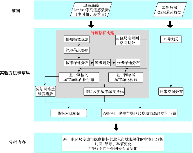
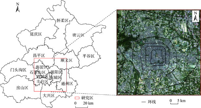
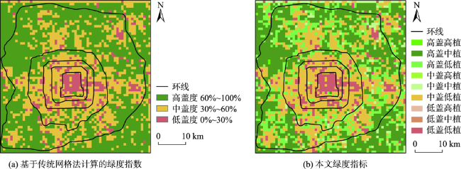
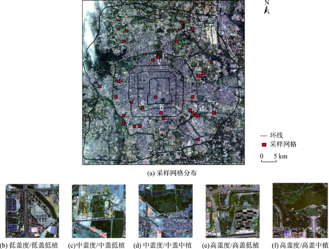
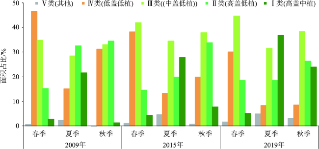
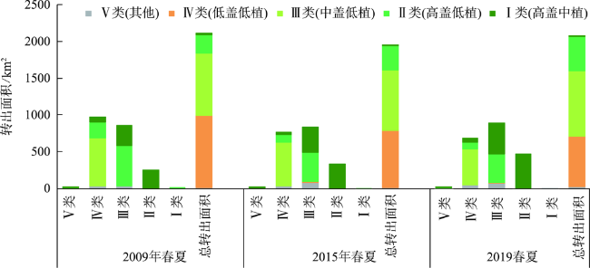
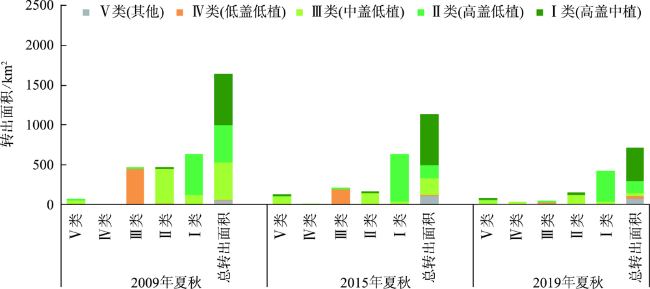
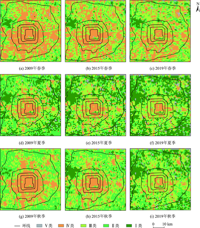
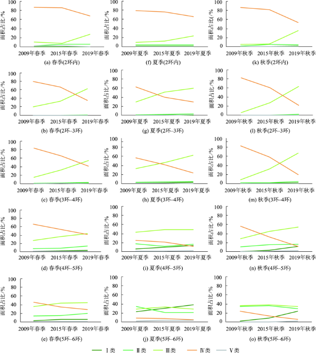
To quantify urban green space using remote sensing data, this paper proposed a grid-based urban green space measurement method at city block scale. The grid unit of 900 m×900 m was set to represent the block scale formed by the main road of the city. The vegetation coverage and vegetation composition were used together to generate the green index in each unit. Unlike the green index calculated by the traditional grid method based on the proportion of vegetation area, the green index in this paper enhanced urban greenness information particularly in areas with moderate to high vegetation coverage. We applied this method in Beijing city and diagnosed the spatiotemporal differences of local urban green space over years. We used Landsat TM/OLI datasets of 2009, 2015, and 2019 in spring, summer, and autumn, respectively. Results showed that both the quantity and quality of urban green space in Beijing have increased significantly from 2009 to 2019, especially in autumn. The changes of urban green space showed different patterns inside and outside of the Fourth Ring Road. Vegetation coverage showed an increase within the Fourth Ring Road, while outside the Fourth Ring Road, there was a significant increase in both vegetation coverage and quality.

LIAO Zhouwei , GUAN Yanning , GUO Shan , CAI Danlu , YU Min , YAO Wutao , ZHANG Chunyan , DENG Rui . A Measure of Block Scale Urban Green Index in Urban Area based on Grid Method[J]. Journal of Geo-information Science, 2022 , 24(8) : 1475 -1487 . DOI: 10.12082/dqxxkx.2022.210743
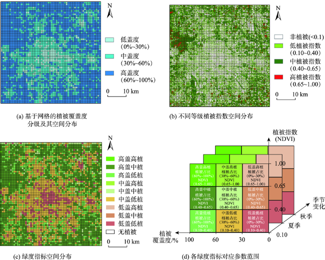
图2 研究区绿度指标构成示意图(2019年8月17日)Fig. 2 Schematic diagram of green index composition in study area (August 17, 2019) |
表1 不同类型绿度指标对应地表绿化概况Tab. 1 Different types of green index correspond to the status of surface greening |
| 绿度指标 | 对应地表绿化特征 |
|---|---|
| 低盖低植 | 单位面积内植被较少,且基本单元内绿化构成主体为冠层繁茂程度和多样性水平较低,总体情况相对较差的植被 |
| 低盖中植 | 单位面积内植被较少,基本单元内绿化构成主体植被情况处于中等水平 |
| 低盖高植 | 单位面积内植被较少,但基本单元内绿化构成主体为冠层繁茂程度、多样性水平较高,总体情况良好的植被 |
| 中盖低植 | 单位面积内植被数量中等,但基本单元内绿化构成主体为冠层繁茂程度和多样性水平较低,总体情况相对较差的植被 |
| 中盖中植 | 单位面积内植被数量中等,基本单元内绿化构成主体植被情况处于中等水平 |
| 中盖高植 | 单位面积内植被数量中等,但基本单元内绿化构成主体为冠层繁茂程度、多样性水平较高,总体情况良好的植被 |
| 高盖低植 | 单位面积内植被较多,但基本单元内绿化构成主体为冠层繁茂程度和多样性水平较低,总体情况相对较差的植被 |
| 高盖中植 | 单位面积内植被较多,但基本单元内绿化构成主体植被情况处于中等水平 |
| 高盖高植 | 单位面积内植被较多,且基本单元内绿化构成主体为冠层繁茂程度、多样性水平较高,总体情况良好的植被 |
表2 数据时相Tab. 2 Acquisition date |
| 年份 | 春季 | 夏季 | 秋季 |
|---|---|---|---|
| 2009 | 20090517/TM | 20090720/TM | 20090922/TM |
| 2015 | 20150518/OLI | 20150822/OLI | 20150923/OLI |
| 2019 | 20190513/OLI | 20190817/OLI | 20190918/OLI |
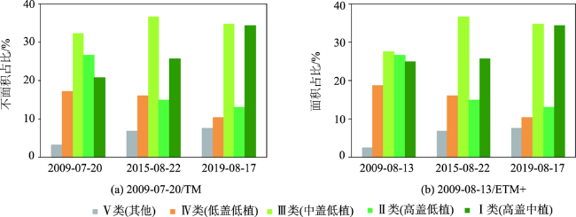
图5 基于高分二号影像的本文绿度指标和传统绿度指数实地对比验证Fig. 5 Comparison and verification of two green indexs based on GF-2 Image |
表3 基于网格单元的绿度指标差异对比Tab. 3 Comparison of green index differences |
| 指标 | 本文绿度指标 | |||
|---|---|---|---|---|
| 低盖低植/中盖低值/高盖低植 | 低盖中植/中盖中值/高盖中植 | 低盖高植/中盖高值/高盖高植 | ||
| 传统网格法计 算的绿度指数 | 低覆盖度 | 10 | 0 | 0 |
| 中覆盖度 | 7 | 3 | 0 | |
| 高覆盖度 | 5 | 5 | 0 | |
| [1] |
邱国玉, 张晓楠. 21世纪中国的城市化特点及其生态环境挑战[J]. 地球科学进展, 2019, 34(6):640-649.
[
|
| [2] |
|
| [3] |
|
| [4] |
熊鹰, 章芳. 基于多源数据的长沙市人居热环境效应及其影响因素分析[J]. 地理学报, 2020, 75(11):2443-2458.
[
|
| [5] |
邵帅, 李欣, 曹建华. 中国的城市化推进与雾霾治理[J]. 经济研究, 2019, 54(2):148-165.
[
|
| [6] |
王占山, 李云婷, 陈添, 等. 2013年北京市PM2.5的时空分布[J]. 地理学报, 2015, 70(1):110-120.
[
|
| [7] |
|
| [8] |
苏泳娴, 黄光庆, 陈修治, 等. 城市绿地的生态环境效应研究进展[J]. 生态学报, 2011, 31(23):7287-7300.
[
|
| [9] |
胡云锋, 赵冠华, 张云芝. 北京城市绿化的时空动态分析[J]. 地球信息科学学报, 2018, 20(3):332-339.
[
|
| [10] |
|
| [11] |
崔佳奇, 刘宏涛, 陈媛媛. 中国城市建成区绿化覆盖率变化特征及影响因素分析[J]. 生态环境学报, 2021, 30(2):331.
[
|
| [12] |
刘晔. 我国城镇化率对建成区绿化覆盖率的影响研究[D]. 苏州: 苏州科技大学, 2017.
[
|
| [13] |
易扬, 胡昕利, 史明昌, 等. 基于MODIS NDVI的长江中游区域植被动态及与气候因子的关系[J]. 生态学报, 2021, 41(19):7796-7807.
[
|
| [14] |
谢舒笛, 莫兴国, 胡实, 等. 三北防护林工程区植被绿度对温度和降水的响应[J]. 地理研究, 2020, 39(1):152-165.
[
|
| [15] |
|
| [16] |
马默衡, 薛飞, 党安荣, 等. 基于动态遥感数据的北京主城区环带间植被覆盖变化[J]. 环境工程技术学报, 2019, 9(4):404-143.
[
|
| [17] |
刘玉琴. 基于建筑物尺度的城市绿度空间遥感建模研究[D]. 福州: 福州师范大学, 2014.
[
|
| [18] |
吴俊, 孟庆岩, 占玉林, 等. 一种基于移动窗口的城市绿度遥感度量方法[J]. 地球信息科学学报, 2016, 18(4):544-552.
[
|
| [19] |
|
| [20] |
|
| [21] |
|
| [22] |
|
| [23] |
|
| [24] |
李志强, 周伟奇. 街区尺度城市内部动态度的量化——以深圳市为例[J]. 生态学报, 2021, 41(6):2180-2189.
[
|
| [25] |
赵格. 城市网格形态研究[D]. 天津: 天津大学, 2008.
|
| [26] |
于立忠, 于水强, 史建伟, 等. 不同类型人工阔叶红松林高等植物物种多样性[J]. 生态学杂志, 2005, 24(11):1253-1257.
[
|
| [27] |
|
| [28] |
|
| [29] |
|
| [30] |
|
| [31] |
|
| [32] |
姚武韬, 关燕宁, 郭杉, 等. 三亚热带雨林环境植被和地表能量空间分布特征[J]. 地球信息科学学报, 2017, 19(7):950-961.
[
|
| [33] |
王昭. 城市小尺度街区研究[D]. 合肥: 合肥工业大学, 2013.
[
|
| [34] |
|
| [35] |
|
| [36] |
|
| [37] |
|
| [38] |
肖彦, 绿色尺度下的城市街区规划初探[D]. 武汉: 华中科技大学, 2011.
[
|
| [39] |
严亚瓴. 20世纪80年代至今北京城市绿色空间演变及机制研究[D]. 北京: 北京林业大学, 2017.
[
|
/
| 〈 |
|
〉 |