
Journal of Geo-information Science >
Comprehensive Vitality Evaluation of Urban Blocks based on Multi-source Geographic Big Data
Received date: 2021-04-25
Revised date: 2021-06-14
Online published: 2022-10-25
Supported by
National Natural Science Foundation of China(41101374)
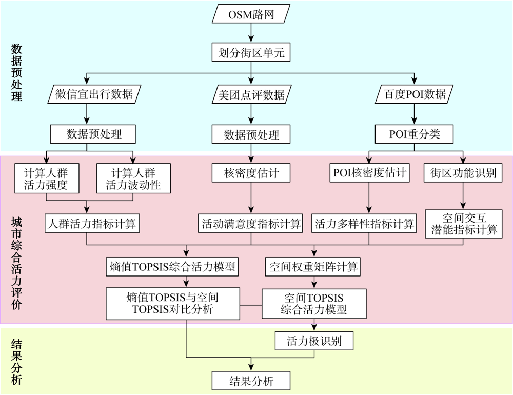
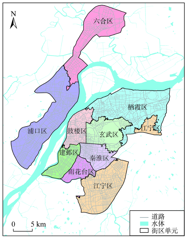
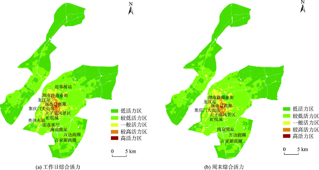
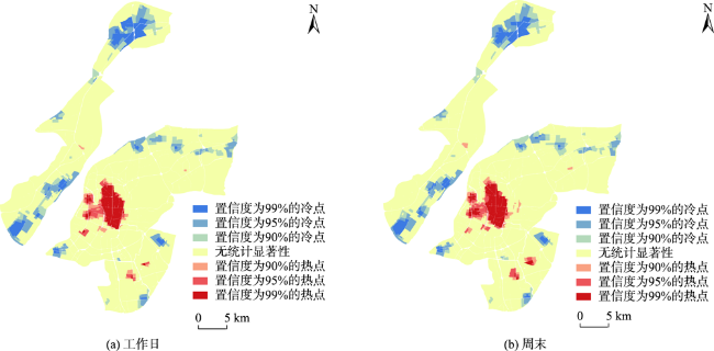
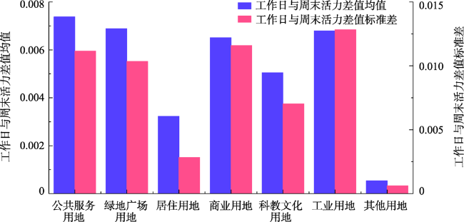
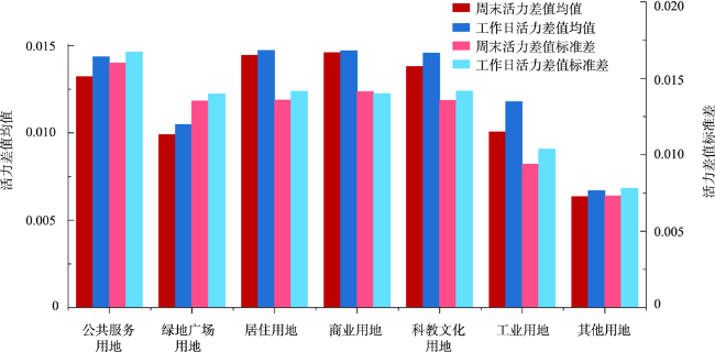
How to conduct quantitative analysis of urban vitality in a scientific and efficient manner has become a key research issue nowadays. Based on the multi-source geographic big data such as OpenStreetMap, Baidu Map POI, WeChat Travel, Meituan, Gaode building outlines, etc., and from the dual perspectives of people and space, this study selects indicators from four aspects, including crowd vitality, diversity of vitality, activity satisfaction, and spatial interaction potential, to construct a comprehensive vitality evaluation model of Spatial TOPSIS. Using the model, this study evaluates the comprehensive vitality of the downtown area of Nanjing, analyzes the spatial distribution characteristics of the vitality of the neighborhood, and explores the similarities and differences of vitality poles between weekdays and weekends. The evaluation results are compared with that of Entropy TOPSIS, in an effort to explore the impact of spatial interaction on the vitality of blocks. This study aims to help urban planners to understand the current status of urban vitality systematically, and provide a feasible plan for urban planning research. The research shows that, firstly, the spatial distribution characteristics of the comprehensive vitality of the downtown blocks in Nanjing urban center are similar between weekdays and weekends. However, the comprehensive vitality of the blocks on weekdays is higher than that on weekends. From the perspective of block functions, the high-value areas of comprehensive vitality are mainly concentrated in commercial centers, tourist attractions, and transportation hubs, which are closely related to the distribution of transportation stations (e.g. subway stations). Secondly, based on the vitality analysis of weekdays and weekends, it is found that Hunanlu - Xinjiekou - Confucius temple scenic area is the largest and most stable vitality pole. Among the small vitality poles, only Longjiang Metro Station has begun to take shape. Other small vitality poles, including Jiqingmen Street, Olympic Sports Center, Baijiahu Commercial District, and Wanda Commercial District, are unstable. Their vitality is still growing. Thus, they may become bigger vitality poles in the future. Thirdly, both the high vitality blocks in the center of the study area and the low vitality blocks receive less spatial effects. The areas with the greatest vitality change are generally distributed in a ring shape around the periphery of the central city. Combining the block functions, it is found that the comprehensive vitality of block units of other land and industrial land is less affected by the spatial interaction. In comparison, residential, commercial, scientific, educational, and cultural land are greatly affected by spatial interaction.
TANG Lu , XU Hanwei , DING Yanwen . Comprehensive Vitality Evaluation of Urban Blocks based on Multi-source Geographic Big Data[J]. Journal of Geo-information Science, 2022 , 24(8) : 1575 -1588 . DOI: 10.12082/dqxxkx.2022.210226
表1 城市街区综合活力量化指标Tab. 1 Quantitative index of comprehensive vitality of urban blocks |
| 一级指标 | 二级指标 |
|---|---|
| 人群活力 | 人群活力强度 |
| 人群活力波动性 | |
| 活力多样性 | 土地利用多样性 |
| 活动满意度 | 活动满意度 |
| 空间交互潜能 | 点度中心度 |
表2 不同功能区类型间的引力系数Tab. 2 Gravitational coefficient between different functional area types |
| 居住 | 商业 | 工作 | 公服 | 科教 | 绿地 | 其他 | |
|---|---|---|---|---|---|---|---|
| 居住 | 0.5 | 1 | 1 | 0.8 | 0.8 | 0.8 | 0.1 |
| 商业 | 1 | 0.6 | 1 | 0.8 | 0.8 | 0.8 | 0.1 |
| 工作 | 1 | 1 | 0.5 | 0.8 | 0.5 | 0.6 | 0.1 |
| 公服 | 0.8 | 0.8 | 0.8 | 0.6 | 0.6 | 0.6 | 0.1 |
| 科教 | 0.8 | 0.8 | 0.5 | 0.6 | 0.5 | 0.6 | 0.1 |
| 绿地 | 0.8 | 0.8 | 0.6 | 0.6 | 0.6 | 0.6 | 0.1 |
| 其他 | 0.1 | 0.1 | 0.1 | 0.1 | 0.1 | 0.1 | 0.1 |
表3 融合多源地理大数据的城市街区综合活力评价研究数据Tab. 3 Research data of comprehensive vitality evaluation of urban blocks based on multi-source geographic big data |
| 数据类型 | 数据名称 | 数据来源 | 年份 |
|---|---|---|---|
| 基础地理数据 | 行政边界矢量数据 | 基础地理国情监测数据 | 2017 |
| 水系数据 | 基础地理国情监测数据 | 2017 | |
| 路网数据 | OpenStreetMap官网 | 2019 | |
| 网络开源数据 | POI数据 | 百度地图爬虫 | 2019 |
| 微信宜出行数据 | 腾讯大数据平台爬虫 | 2019 | |
| 商铺口碑评分数据 | 美团网爬虫 | 2020 | |
| 建筑物轮廓数据 | 高德地图爬虫 | 2019 |
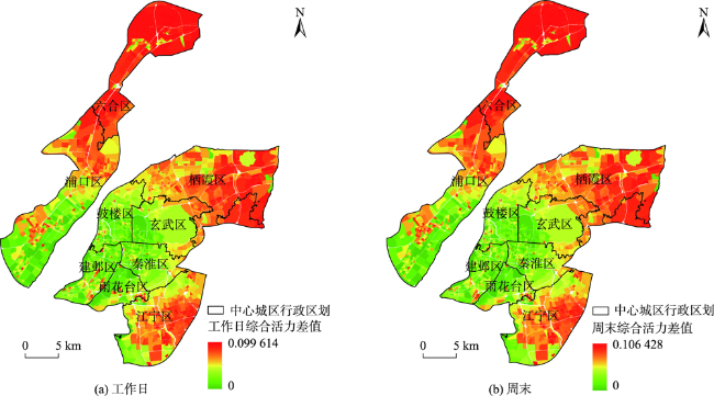
图3 南京市中心城区街区综合活力空间分布Fig. 3 The spatial distribution of comprehensive vitality in the downtown area of Nanjing |
表4 综合活力分级范围Tab. 4 Comprehensive vitality classification range |
| 综合活力分级 | 工作日综合活力 | 周末综合活力 |
|---|---|---|
| 低活力区 | 0.00 ~ 0.04 | 0.00 ~ 0.04 |
| 较低活力区 | 0.04 ~ 0.08 | 0.04 ~ 0.08 |
| 一般活力区 | 0.08 ~ 0.12 | 0.08 ~ 0.12 |
| 较高活力区 | 0.12 ~ 0.28 | 0.12 ~ 0.29 |
| 高活力区 | 0.28 ~ 0.63 | 0.29 ~ 0.57 |
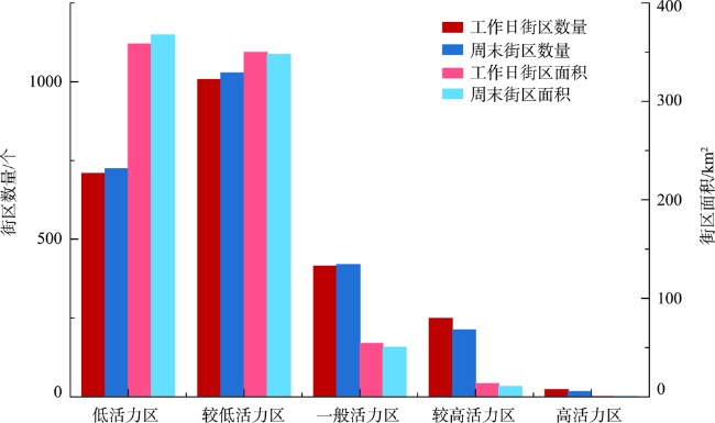
表5 工作日、周末各类活力街区数量与面积Tab. 5 Number and area of various vibrant blocks on weekdays and weekends |
| 综合活力 分级 | 工作日 | 周末 | |||
|---|---|---|---|---|---|
| 街区数量 /个 | 街区面积 /km2 | 街区数量 /个 | 街区面积 /km2 | ||
| 低活力区 | 709 | 358.32 | 724 | 367.47 | |
| 较低活力区 | 1006 | 349.75 | 1028 | 347.80 | |
| 一般活力区 | 415 | 54.15 | 420 | 50.15 | |
| 较高活力区 | 249 | 13.40 | 213 | 10.38 | |
| 高活力区 | 23 | 0.56 | 17 | 0.37 | |
| [1] |
王玉琢. 基于手机信令数据的上海中心城区城市空间活力特征评价及内在机制研究[D]. 南京: 东南大学, 2017.
[
|
| [2] |
范冬婉. 时空大数据支持下的城市活力测量方法及增长策略研究[D]. 武汉: 武汉大学, 2019.
[
|
| [3] |
翁世杰. 武汉市城市活力分析——以三环内主城区为例[D]. 武汉: 武汉大学, 2019.
[
|
| [4] |
|
| [5] |
|
| [6] |
|
| [7] |
|
| [8] |
蒋涤非. 城市形态活力论[M]. 南京: 东南大学出版社, 2007.
[
|
| [9] |
龚颖. 城市公共空间活力研究[D]. 武汉: 中国地质大学, 2009.
[
|
| [10] |
李万林. 城市公共空间的活力与特征浅述[J]. 重庆建筑, 2011, 10(12):10-12.
[
|
| [11] |
汤华杰. 加快城市活力空间建设的思考[J]. 中国国情国力, 2017(5):48-49.
[
|
| [12] |
|
| [13] |
|
| [14] |
杨喜平, 方志祥. 移动定位大数据视角下的人群移动模式及城市空间结构研究进展[J]. 地理科学进展, 2018, 37(7):880-889.
[
|
| [15] |
|
| [16] |
|
| [17] |
|
| [18] |
陈佳, 胡波, 左小清, 等. 利用手机定位数据的用户特征挖掘[J]. 武汉大学学报·信息科学版, 2014, 39(6):734-738,744.
[
|
| [19] |
钟炜菁, 王德, 谢栋灿, 等. 上海市人口分布与空间活动的动态特征研究——基于手机信令数据的探索[J]. 地理研究, 2017, 36(5):972-984.
[
|
| [20] |
罗桑扎西, 甄峰. 基于手机数据的城市公共空间活力评价方法研究——以南京市公园为例[J]. 地理研究, 2019, 38(7):1594-1608.
[
|
| [21] |
王波, 甄峰, 张浩. 基于签到数据的城市活动时空间动态变化及区划研究[J]. 地理科学, 2015, 35(2):151-160.
[
|
| [22] |
张莹. 城市街区活力测度及影响机制研究——以武汉市主城区为例[D]. 武汉: 武汉大学, 2019.
[
|
| [23] |
|
| [24] |
|
| [25] |
|
| [26] |
|
| [27] |
|
| [28] |
宁晓平. 土地利用结构与城市活力的影响分析[D]. 深圳: 深圳大学, 2016.
[
|
| [29] |
赵卫锋, 李清泉, 李必军. 利用城市POI数据提取分层地标[J]. 遥感学报, 2011, 15(5):973-988.
[
|
| [30] |
谢超. 城市网络格局下的新城活力表征研究——以广州珠江新城为例[D]. 哈尔滨: 哈尔滨工业大学, 2020.
[
|
| [31] |
倪艳亭, 崔雁冰. 基于改进TOPSIS法的济南都市圈城市创新能力空间分异研究[J]. 地域研究与开发, 2019, 38(6):63-67.
[
|
| [32] |
|
| [33] |
OpenStreetMap基金会. OpenStreetMap[EB/OL]. https://www.openstreetmap.org/,2021.
[OSMF. OpenStreetMap[EB/OL]. https://www.openstreetmap.org/,2021.
|
| [34] |
中华人民共和国住房和城乡建设部. 中华人民共和国城镇建设工程标准:城市道路工程设计规范CJJ 37-2012[S]. 北京: 中国建筑工业出版社, 2012.
[Ministry of Housing and Urban-Rural Development of the People's Republic of China. Code for design of urban road engineering. CJJ 37-2012[S]. Beijing: China Architecture & Building Press, 2012. ]
|
| [35] |
|
| [36] |
|
| [37] |
中华人民共和国住房和城乡建设部. 中华人民共和国国家标准:城市用地分类与规划建设用地标准GB 50137-2011[S]. 北京: 中国计划出版社, 2012.
[Ministry of Housing and Urban-Rural Development of the People's Republic of China. National Standard (Mandatory) of the People's Republic of China: Code for classification of urban land use and planning standards of development land. GB 50137-2011[S]. Beijing: China Planning Press, 2012. ]
|
/
| 〈 |
|
〉 |

